
Baker and his section through, and map of, the Allah Bund
W. E. Baker (1808-81) of the Royal Engineers [1] worked in Sindh 1843-44 during which time he wrote a dozen reports for Sir Charles Napier who had recently annexed Sindh to British India following a series of successful battles (from the point of view of the British), for which he had been rewarded by being appointed its governor. Requesting the government to provide him with the most competent canal engineer available, Lord Ellenborough appointed Baker "Superintendent of Canals and Forests in Sind". In October 1843 Baker arrived at Sukkur in upper Sindh traveling from the Punjab. A year later, in October 1844, he departed to continue canal works in northern India.
Baker's 1884 report on the Allah Bund is entitled: "Report on the Bunds across the Goonee and Pooram Rivers obstructing the flow of the Indus water through the Koree or Lukput branch of the river towards Kutch, accompanied by a map of the country from Mora to the Allah Bund" but no copy of this original report appears to have survived. Baker's text and map are not listed in the State Archives of India [Prasad, 1975], or in the collections of the British Library, or in the Geological Survey of India in Calcutta, although there is a chance that a copy exists in Dehra Dun. Phillimore [2] indicates that a number of maps were destroyed in Calcutta c. 1915 due to their poor condition before transfer of the remainder from the Survey of India HQ to the State Archives in Delhi.
Two years after its completion a three page summary of Baker's report [3] was published without the map or section [Baker, 1846]. Henry Yule [1], a close friend of Baker's, was familiar with the original work and in 1882 describes Baker's completion of it as follows "It was a work of great interest and importance, but at that season was a very trying one. For a considerable distance from the Allah Bund and Sindri Lake there was no fresh water. Leaving his camp he surveyed and leveled in one day the whole length that remained to be done, which was 19 miles. He mentioned afterwards having been struck by the remark of one of the survey-men, a Muhammedan which he overheard in his tent "If God had not sent us such clouds today" said the man" we should have had an awful time!". Having had one or two slight attacks of fever in the course of this excursion, Baker was a trifle knocked up on his return to Karachi, but soon regained his strength. He had surveyed the line of march daily. [pp35-6, Yule and Maclagan,1882].
Yule and Maclagan [1882] indicate that the work on the Pooran was undertaken between 25 June to 30 July 1844 which included travel to the field area (probably from Hyderabad outward and back via Thatta). It consisted of a 37 mile leveling survey of both the bank and the river bed, which, except for stagnant pools, was at the time dry between the reservoir north of the Mora Bund and Lake Sindri in the south. He records the level of the Mora Bund on 8 July and at Lake Sindri on 11 July 1844 suggesting that the leveling (as opposed to the ten mile wide swath-mapping) was undertaken southwards in 4 days, a mean traverse rate of 9 miles a day. Yule indicates, however, that the southernmost 19 miles (just over half the distance) were completed on the last day. This roughly corresponds to the Pooran river section between Lallan Puttan Dam and Lake Sindri. The leveling from the north thus proceeded at 6 miles/day and the last day's survey was three times faster. Yule remarks that Baker found the shores of Lake Sindri "thickly encrusted with dry salt, in which were found numbers of little fish, completely preserved. On the shores of the lake he found the remains of some snakes, and several birds, the skull of a panther, and bones of other animals."
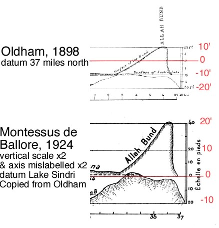
The upper section is Oldham's 1898 copy [3] of Wynne's copy (Wynne describes Baker's section but does not reproduce it- see note [4] below). The slope of the bank of the river in Oldham's copy when projected north/south is 6 m in 47 km . This corresponds to a slope of 1 in 7800 respectively, comparable to the slope of the Rann measured by Siveright (6" per mile), and the slope of the Indus (5.7"/mile) by Tremenheer[1867] which corresponds to a mean slope of 1 in 11000. In contrast, the copy of the section by Montessus de Ballore, which was published posthumously on page 147 of his 1924 book [6] introduces a factor of two error in the vertical axis. The vertical scale of Ballore's section is increased precisely by a factor of two, but in changing the datum the draftsman has mislabeled the vertical scale to correspond to a range of 60 feet instead of 30 feet. My annotations are in red in the sections above and extract below.
 .
.
1. Yule, H, and R. Maclagan, Memoir of General Sir William Erskine Baker, KCB, Royal Engineers (Bengal) compiled by two old friends, brother officers and pupils, by HY and RM, Printed for Private Circulation, London 1882 67pp. [Colonel Henry Yule and Major General R. Maclagan]. Henry Yule bequeathed his personal copy of this booklet to the British Museum in a bound volume with other biographies that he had published. It contains a striking portrait photograph of Baker aged about 50. Yule describes the ruins surrounding Fort Sindri: "but when the fresh supplies [of water from the Puram] were cut off from above, the salt soon prevailed again. Then the influx of sea water, in turn, had diminished and exposed more of the buildings", and the elevation of the Allah Bund thus, "This great bank, is raised above that of the land, for it is 50 miles in length, 15 broad and up to 10 feet high, was cast up by the violent earthquake of 16 June 1819". Yet the remark 'up to 10 feet high" presents a problem if Yule, himself an RE, had the map in front of him when he made this remark. He may have here been influenced by the later discussion of Wynne[1872] who points out that if the upift was 20 feet it would have favored a diversion of the river westwards or eastwards around the Bund.
2. R. H. Phillimore wrote to the Surveyor General of the Survey of India in Dehra Dun on 8 July 1949 [S1:15 of SGO file 1046 Collection IX. He notes that Fred Fraser Hunter worked at the Map Issue and Record office in Calcutta in about 1913-5 and "found the collection of old maps in a state of complete chaos, stacked together regardless of geographical areas, or periods, or value. He spent at least six months in their arrangement and "weeding' for he found a great many that appeared to him to be of no interest whatever and many that were in such a shocking condition that he had to destroy them". The contents of this letter is quoted by J.A.F. Dalal in his Introduction to Prasad[1975]. Since Baker's report included text one can hope that it was not one of the items destroyed at this time, but two maps of Baker's 1843-44 works were included in the items now in the archives - see entry on Prasad [5] below.
3. Baker, W. E., (1844), Remarks on the Allah Bund and on the drainage of the eastern part of the Sind basin, Trans. Bombay Geogr. Soc., 7, 186-188. The pdf accessible here includes the map from Oldham[1898] that was omitted by the editor in 1846.
4. Wynne, A. B., (1873). Memoir on the Geology of Kutch, Mem. Geol. Surv. India, 9, 1-294, 1872 Extract pages 41-43. Wynne states "From the amount of detail in Capt. Baker's section it seems to have been very well constructed" and it is very probable that he was looking at the version later published in reduced form by R. D. Oldham, because only with the section in front of him could he describe the crest of the bund "gaining a height of about 19 feet above its lowest point" this lowest point meaning the level of the bank starting 4 miles north of the S. edge of the Bund. Wynne presumably left his section in the Geological Survey of India offices in Bombay where Oldham found it during a clear up in Bombay while he was officiating Director of the GSI in 1897/8. Wynne argues that the 19 foot elevation of the crest of the bund would have dammed the region locally to such a degree that the river would have passed around it. But he concedes that the raised bed was only 7 feet higher than the salt water pools north of the Bund whose base elsewhere were possibly 12-20 feet lower than the bank. He recognized that the lowest point of the bed of the Puram through the Bund is crucial because it this lip that would have dammed the river before it broke through in 1926. See discussion .html on geometry of Sindri and the Allah Bund.
5. Prasad, S. N., 1975. Catalogue of the historical maps of the survey of India (1700-1900). pp. 543. Govt. of India. The only two maps specifically attributed to Baker in this catalog are F.121/39 Sketch of part of Upper Scinde Scale 1"=4 miles. Reduced from Captain Baker's map. Copied in 1849, and F117/22 Sketch of a route map from Tatta to Raoma Bazar, and the Allah Bund. Scale 1"-10 miles, By Capt. W. E. Baker. The latter may be the route taken by Baker at the end or start of his June/July 1844 Survey.
6. F. Comte de Montessus de Ballore, 1924. La Geologie Sismologique, Lib A. Colin, Paris. pp 488. extract pages 137-148