Haiti Earthquake 9 Mar 2010 Update
Tide Gauge Data from 6 March on line
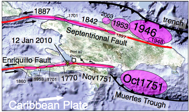
click on map for pdf. Historical earthquakes from Bill McCann. Size of ellipsii proportional to approximate magnitude, locations approximate.
Lessons from the Haiti Earthquake- Nature 18 Feb
Democracy Now - Amy Goodman Interview
Surficial fractures (updated 21 Feb 2010)
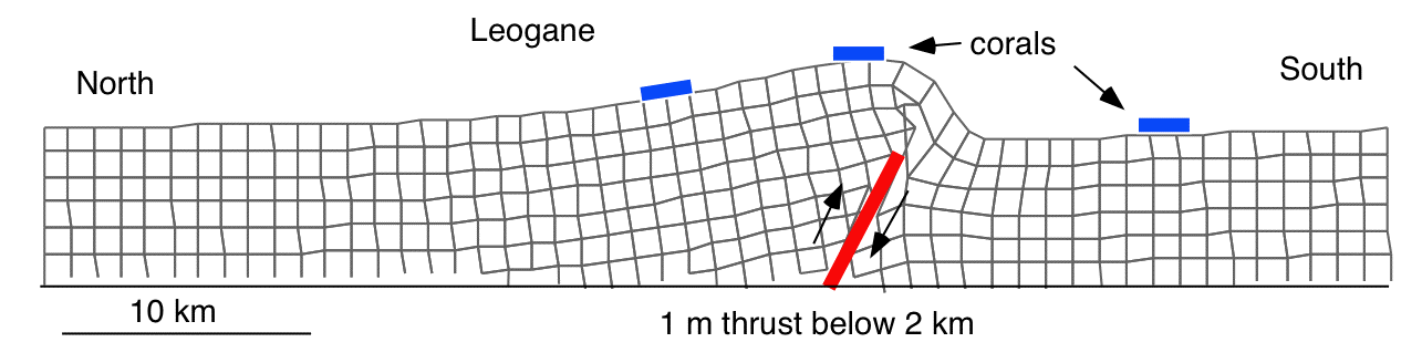
Helicopter traverse 25 January (Plate boundary
Liquefaction Port au Prince Harbour (23 January)
Damage report (22 & 23 January)
Clickable Uplift/Subsidence/Intensity Map
Post seismic PowerPoint File for classroom use (! 21Mb)
Mainshock 12 Jan 2010 at 04:53:10 PM local time at 8 km
Prelim. Epicenter 18.457 deg N, 72.533 deg W, Mw =7.0 USGS centroid solution 18.826 -72.162 HCMT solution 18.62 N, 72.59 E.
Numerous large jpegs can be downloaded for educational use through links at the bottom of this pag .
Fatalities
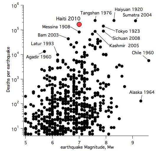
The urban agglomeration of Port-au-Prince has expanded rapidly in the past decade and before the earthquake exeeded 2 million. The death toll was estimated at 230,000 (12 Feb) but it is likely that the true count will never be known precisely.
With a Richter magnitude of M=7 the Haiti earthquake is classed as a major earthquake, however, no previous M=7 earthquake has resulted in this many fatalities (the Messina earthquake of 1908 killed 82k). At 230k, the deathtoll is close to being the most lethal earthquake since 1900, and the second most lethal earthquake ever. The large death-toll was caused by the almost complete absence of earthquake resistance in most of the structures in Port-au-Prince and the surrounding towns and villages.
I estimate the cost of reconstructing Port au Prince and its surroundings as approximately $20 biliion. The estimate is based on rebuilding of 250,000 dwellings and civic buildings (schools etc) at an average cost of $80k including associated infrastructure - temporary housing, water supply, sewer, power distribution, roads and port facilities. Economists at the Inter-American Development Bank on 17 Feb 2010 suggested the figure may be as low as $8-$14 billion.
A recent article (2009) discussing the seismic future of cities may be downloaded here. It forecasts a rising deathtoll from earthquakes, especially in the developing nations, where earthquake resistance building codes are either absent or not enforced. A two page building code existed in Haiti before the earthquake, which was used by engineers but not by most of the contractors in the country. After the Earth Quakes by Susan Hough and Roger Bilham (2001) discusses the increasing problem of urban earthquakes. In a Feb 2010 Nature article I argue that the UN should implement a global task force to prevent the construction of non-earthquake resistant structures in any city with a history of damaging earthquakes. Unsafe buildings are weapons of mass destruction.
Link to Photos of damage in Port au Prince
Link to helicopter views Leica
Link to views of Port Damage, Cite Soleil and Villagers west.