Bilham, R., V. K. Gaur and P. Molnar, Himalayan Seismic Hazard, Science, 293, 1442-4, 2001. Science Magazine Dowload.
PERSPECTIVE: EARTHQUAKES
Himalayan Seismic Hazard
Roger Bilham, Vinod K. Gaur, Peter Molnar
R. Bilham and P. Molnar are in the Department of Geological Sciences and the Cooperative Institute for Research in environmental Sciences, University of Colorado, Boulder, CO 80309, USA. E-mail: bilham@colorado.edu. V. K. Gaur is in the Indian Institute for Astrophysics, Bangalore 560 034, India.
Five major earthquakes have visited India in the past decade (see the table), culminating in the devastating Bhuj earthquake of 26 January 2001. That earthquake in particular called attention to the hazards posed by buildings not designed to withstand major but obviously probable earthquakes. It also focused the eyes of the public away from a part of India where even worse damage and loss of life should be expected-the Himalayan arc (see the figure). Several lines of evidence show that one or more great earthquakes may be overdue in a large fraction of the Himalaya, threatening millions of people in that region.
A wealth of geophysical evidence demonstrates that south of the
Himalaya, the top surface of India's basement rock flexes and
slides beneath the Himalaya-not steadily but in lurches during
great earthquakes (see the inset in the first figure) (1,
2). This pattern resembles that found where lithospheric
plates beneath oceanic regions converge rapidly: that is at deep-sea
trenches, where the ocean floor flexes down seaward of the trench,
the entire oceanic lithosphere plunges deep into the Earth's mantle,
and great earthquakes occur most commonly. Extreme examples are
the great earthquakes in Chile in 1960 and in Alaska in 1964.
Only during such earthquakes does the entire plate boundary rupture.
Second, Global Positioning System (GPS) measurements show that
India and southern Tibet converge at 20 ± 3 mm/year (3).
A 50 km-wide region centered on the southern edge of the Tibetan
Plateau strains to absorb about 80% of this convergence. This
region also shows localized vertical movement (4), and small
earthquakes are most common here (5). The surrounding Himalaya
accommodates the remaining 20%. Two meters of potential slip in
earthquakes thus accumulate each century. In contrast, control
points in southern India and southernmost Nepal approach each
other no faster than a few mm/year (6). As the Bhuj earthquake
shows, this deformation, although slow, is far from negligible.
Third, in the Himalaya the potential slip accumulates almost entirely
as elastic rather than inelastic strain, which would permanently
deform the rock. Analyses of deformed river terraces in the foothills
of the Himalaya demonstrate an advance of 21 ± 3 mm/year
in southern Nepal (7) during the past ca. 10,000 years. The minor
difference between this rate, measured at the southern edge of
the Himalaya and applicable to durations spanning many great earthquakes,
and the 20 ± 3 mm/year measured with GPS implies that at
most a small fraction (<10%) of the strain could be inelastic.
Earthquakes must therefore release most, if not all, of India's
2 m/century convergence with southern Tibet.
Little is known about Himalayan earthquakes in the 18th century
and before. Great earthquakes in the Himalayan region occurred
in 1803, 1833, 1897, 1905, 1934 and 1950 (see the figure). The
1803 earthquake caused damage between Delhi and Lucknow. Recent
reëvaluations of the 1833 Nepal (8) and 1905 Kangra earthquakes
(9, 10) indicate that rupture lengths were less than 120 km, smaller
than previously believed (1, 11). An analysis of geodetic deformation
during the 1897 earthquake (12) confirms that it occurred 100
km south of the Himalaya and therefore did not relieve strain
in that belt. Thorough studies of the destruction, and thus the
intensity of shaking for the 1934 Bihar-Nepal earthquake were
carried out in Nepal (13) and India (14). Together with geodetic
constraints (15), they imply that a 200 to 300 km long segment
of eastern Nepal ruptured (16). Similarly, locations of aftershocks
of the 1950 Assam earthquake imply a rupture zone ~200 km long,
with complexities at its eastern end (2, 17).
Although the major earthquakes that have occurred along the Himalaya
since 1800 differed in dimensions. there is no doubt that they
destroyed vast regions along the front of the Himalaya. More important
today, however, less than half of the Himalaya (see the figure)
has ruptured in that period.
Surface ruptures have not been found for any of these events.
There are thus no geological constraints of recent ruptures, and
geologists are concerned that paleoseismic investigations across
Himalayan surface faults may yield misleadingly long recurrence
intervals. Moreover, repeat surveys of trigonometrical points
installed before the 1905, 1934, and 1950 earthquakes have yet
to be made with modern techniques. The amplitudes of long-period
seismic waves have provided quantitative measures of the seismic
moments (a measure of earthquake size) of the 1934 and 1950 earthquakes
(17). Knowledge of the lengths of the ruptures and sensible estimates
of the width from various sources yield ~4 m of slip in 1934 and
~8 m of slip in 1950 (18). Uncertainties in these estimates permit
slip as small as 2 m in 1934 and as high as 16 m for 1950, but
such amounts would be unusual for earthquakes of their magnitude.
These less direct measurements thus imply an average slip of ~4
m during great earthquakes.
Despite the diverse quality of data in the past two centuries,
we can be sure that we are not missing any great event since 1800.
This permits us to estimate the minimum slip potential that has
accumulated along the Himalaya since the last grreat earthquake
(see the figure). We divide the central Himalaya into 10 regions,
with lengths roughly corresponding to those of great Himalayan
ruptures (~220 km). With a convergence rate of 20mm/year along
the arc, six of these regions currently have a slip potential
of at least 4 m-equivalent to the slip inferred for the 1934 earthquake.
This implies that each of these regions now stores the strain
necessary for such an earthquake. Moreover, the historic record
(19-21) records no great earthquake throughout most of the Himalaya
since 1700, suggesting that the slip potential may exceed 6 m
in some places.
Given that geological investigations of the 1905 and 1934 ruptures
did not reveal surface ruptures but that river terraces have been
warped and the foothills have grown during prehistoric great earthquakes,
we cannot rule out the possibility that parts of the Himalaya
have not ruptured in major earthquakes for 500 to 700 years and
will be associated with slip exceeding 10 m. The mid-Himalayan
20th century earthquakes would then have been atypically small.
The weakest link in the arguments above is the uncertainty in
the amount of slip during great earthquakes. Yet, because the
longer the time since the previous earthquake, the larger the
potential slip will be to drive the next one, if the fraction
of the Himalaya due for a major earthquakes is smaller than the
55% we assign it, the more severe those less frequent great earthquakes
will be. Even if only one segment has stored potential slip comparable
to that of the 1950 Assam earthquake, the largest intracontinental
earthquake in recorded history (18), a replication of that earthquake
along the more populous segments of the Himalaya would be devastating.
The population of India has doubled since the last great Himalayan
earthquake in 1950. The urban population in the Ganges Plain has
increased by a factor of ten since the 1905 earthquake, when collapsing
buildings killed 19,500 people (9). Today, about 50 million people
are at risk from great Himalayan earthquakes, many of them in
towns and villages in the Ganges plain. The capital cities of
Bangladesh, Bhutan, India, Nepal, and Pakistan and several other
cities with more than a million inhabitants are vulnerable to
damage from some of these future earthquakes.
The enforcement of building codes in India and Pakistan mitigates
the hazards to this large population, but a comparison between
fatalities in the 1819 Katchch and 2001 Bhuj earthquakes is not
encouraging. The population of Kachch has increased by a factor
of ten. Two thousand fatalites occurred in 1819 (22), compared
to the 18,000 confirmed and possibly 30,000 unconfirmed fatalities
this year. The implemented seismic code apparently did not lessen
the percentage of the population killed. Like the Himalayan earthquakes,
the Bhuj event occurred in an identified zone of heightened seismic
hazard. Projecting these figures to just one of the possibly several
overdue Himalayan earthquakes (for example a repeat of the Kangra
1905 event) yields 200,000 predictable fatalities. Similar conclusions
have been reached by Arya (23). Such an estimate may be too low
by an order of magnitude should a great earthquake occur near
one of the megacities in the Ganges Plain.
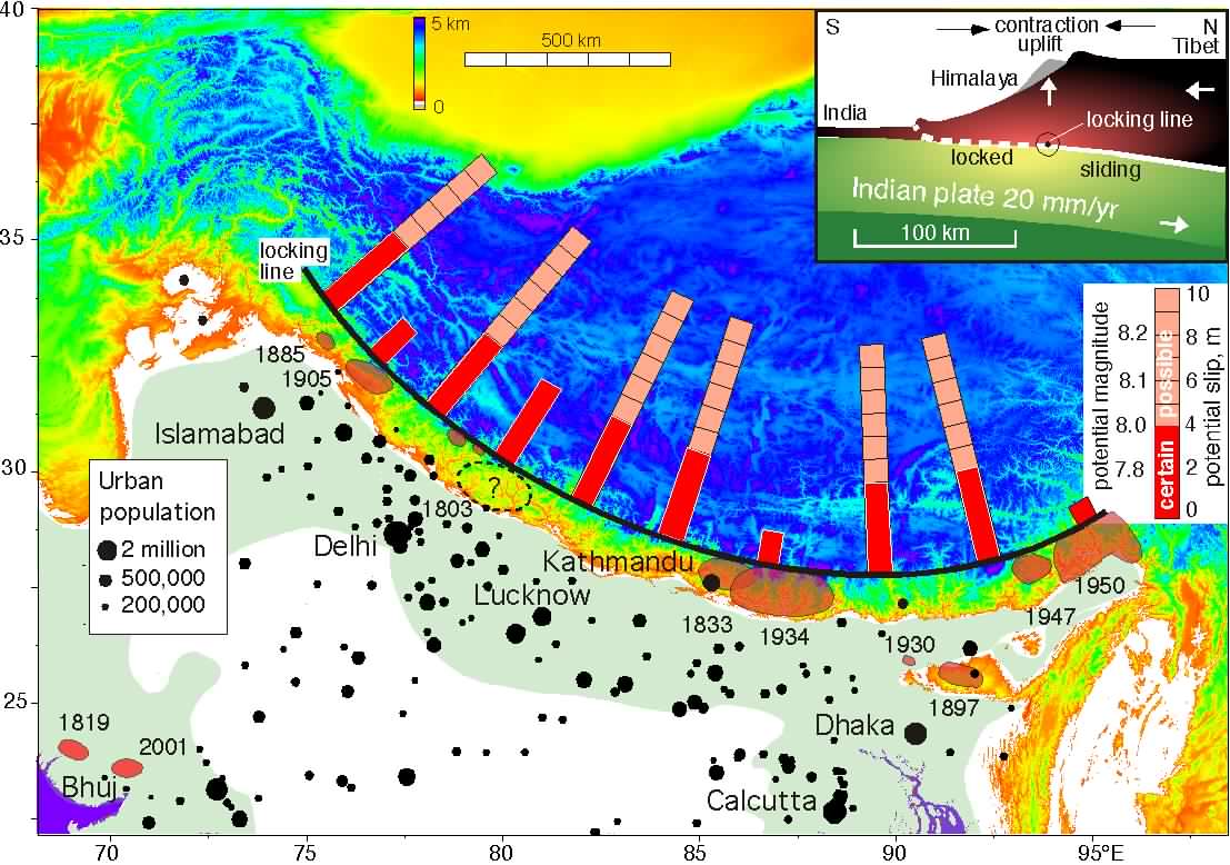
Danger zone. This view of the Indo-Asian collision zone
shows the estimated slip potential along the Himalaya and urban
populations south of the Himalaya (U.N. sources). Shaded areas
with dates next to them surround epicenters and zones of rupture
of major earthquakes in the Himalaya and the Kachchh region, where
the 2001 Bhuj earthquake occurred. Red segments along the bars
show the slip potential on a scale of 1 to 10 meters, that is,
the potential slip that has accumulated since the last recorded
great earthquake, or since 1800. The pink portions show possible
additional slip permitted by ignorance of the preceding historic
record. Great earthquakes may have occurred in the Kashmir region
in the mid 16th century (21) and in Nepal in the 13th century
(8). The bars are not intended to indicate the locus of specific
future great earthquakes, but are simply spaced at equal 220-km
intervals, the approximate rupture length of the 1934 and 1950
earthquakes. Black circles show population centers in the region;
in the Ganges Plain, the region extending ~300 km south and southeast
of the Himalaya, the urban population alone exceeds 40 million.
(inset) This simplified cross section through the Himalaya indicates
the transition between the locked, shallow portions of the fault
that rupture in great earthquakes, and the deeper zone where India
slides beneath Southern Tibet without earthquakes. Between them,
vertical movement, horizontal contraction, and microearthquake
seismicity are currently concentrated (3-5).
References
1. L. Seeber, J. Armbruster, in Earthquake Prediction:
An International Review, Maurice Ewing Series 4, D. W. Simpson,
P. G. Richards, Eds. (Amer. Geophys. Un., Washington, DC, 1981),
pp. 259-277.
2. P. Molnar, J. Himalayan Geology 1, 131
(1990).
3. K. Larson, R. Bürgmann, R. Bilham, J. Freymueller, J.
Geophys. Res. 104, 1177, (1999).
4. M. Jackson, R. Bilham, J. Geophys. Res. 99,
13897 (1994).
5. M. Pandey et al., Geophys. Res. Lett., 22,
751 (1995).
6. J. Paul et al., Geophys. Res. Lett. 28,
647 (2001).
7. J. Lavé, J.-Ph. Avouac, J. Geophys. Res. 105,
5735 (2000 )
8. R. Bilham, Current Science 69, 155 (1995).
9. N. Ambraseys, R. Bilham, Current Science 79,
101 (2000).
10. R. Bilham, Geophys. J. Int. 144, 1 (2001).
11. C. S. Middlemiss, The Kangra Earthquake of 4th April, 1905,
Mem. Geol. Surv. India, Vol. 37 (Geol. Surv. India, Calcutta,
1910; reprinted 1981).
12. R. Bilham, P. England, Nature 410, 806, (2001).
13. Rana, Maj. Gen. Brahma Sumsher J. B., Nepalko Maha Bhukampa
(The Great Earthquake of Nepal), published by the author in
Kathmandu, Second ed. 1935.
14. J. A. Dunn, J. B. Auden, A. M. N. Ghosh, D. N. Wadia,
The Bihar Earthquake of 1934, Geol. Surv. India Mem.
73, 1939.
15. R. Bilham, F. Blume, R. Bendick, V. K. Gaur, Current Science
74, 213 (1998).
16. M. R. Pandey, P. Molnar, J. Geol. Soc. Nepal 5,
22 (1988).
17. W.-P. Chen, P. Molnar, J. Geophys. Res. 82,
2945 (1977).
18. P. Molnar, Deng Q., J. Geophys. Res. 89,
6203 (1984).
19. A. Bapat, R. C. Kulkarni, S. K. Guha, Catalog of Earthquakes
in India and Neighborhood from historical period up to 1979
(Ind. Soc. Earthq. Tech, Roorkee, 1983), 211 pp.
20. K. N. Khattri, Tectonophysics 138, 79 (1987).
21. R. N. Iyengar, S. D. Sharma, Earthquake History of India
in Medieval Times (Central Building Research Institute, Roorkee,
1998), 124 pp.
22. R. Bilham, in Coastal Tectonics, I. S. Stewart, C.
Vita-Finzi, Eds. (Geol. Soc. London, London, 1999), pp. 295-318.
23. A. S. Arya, Current Science 62, 251 (1992).
Table 1 Fatalities from earthquakes in India, and estimates
of rupture parameters of Himalayan earthquakes
Rupture zones entered in italics are constrained by seismic
or geodetic data. The range of uncertainty in rupture parameters
is indicated by a minimum and maximum slip estimate.
magnitude fatalities length width slip (m) ref.
date latitude longitude Ms km km min. max.
1720 Jul 15 29 77.5 Delhi ? ? 27
1819 Jun 16 23.6 68.6 Kachchh 7.7±0.2 2000 120 15 9
12 28
1737 Sep 30 not an earthquake Calcutta - <3000 29
1803 Sept 1 30 78 Kumaon 8? ? 120 60 2 6 27
1833 Aug 26 28 88.5 Kathmandu 7.7±0.2 500 120 70 2 3
9
1869 Jan 10 25 93 Cachar 7.5 2 15
1885 May 30 34.1 74.6 Sopor, Kashmir 7 3000 30 20 1 2 26
1897 Jun 12 26 91 Shillong 8.1±0.1 1542 110 35 10 20
14
1905 Apr 04 32.3 76.3 Kangra 7.8±0.2 19500 120 60 2
5 11
1918 Jul 08 24.5 91 Srimigal,Bengal 7.6 ? 26
1930 Jul 02 25.8 90.2 Dhubri, Assam 7.1 0 26
1934Jan 15 26.6 86.8 Bihar/Nepal 8.2±0.1 10500 220 80
3 5 22
1943 Oct 23 26.8 93 Assam 7.2 ? 26
1947 Jul 29 28.63 93.73 Assam 7.7 ? 100 50 2 4 22
1950 Aug15 28.5 96.7 ArunchalPradesh 8.5 1542 200 90 6 20
32
1956 Jul21 23.3 70 Anjar 7 113 36
1967 Dec10 17.37 73.75 Koyna 6.5 177 36
1970 Mar 23 21.7 73 Broach 5.4 30 36
1975 Jan 19 32.38 78.49 Kinnaur 6.2 60 36
1988 Aug 06 25.13 95.15 Manipur 6.6 35 36
1988 Aug 21 26.72 86.63 Udaypur 6.4 6500 36
1991 Oct 20 30.75 78.86 Uttarkashi 6.6 769 36
1993 Sep 30 18.07 76.62 Latur 6.3 7610 36
1997 May 22 23.08 80.06 Jabalpur 6 39 36
1999 Mar 29 30.41 79.42 Chamoli 6.8 103 36
2001 Jan 26 23.4 70.3 Bhuj 7.6 >20000 36