1934 Mw 8.1 Bihar/Nepal earthquake 15 January 1934
No contemporary surface rupture was reported for this great Himalayan earthquake although one has recently been reported in trench investigations in Nepal. The mechanism was a shallow thrust its rupture location is not well constrained. Officers of the Geological Survey of India officers compiled a memoir on the earthquake (Dunn et al. 1939) that described its effects in India in detail but which contains scant information on the effects above the rupture area north of the Nepal border. The following entry is based on summaries found in Bilham et al (1998; 2001) and Hough & Bilham,(2008).
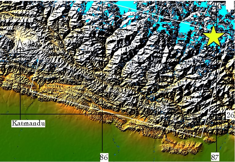
The instrumentally relocated 1934 epicenter lies approximately 10 km south of Mt. Everest at 27.55 N, 87.09 E (Chen and Molnar 1977). These authors calculate a seismic moment of 1.1x10E28 dyne cm and a slip of 5.4m assuming a 130-50 sq km area rupture corresponding to Mw = 8.0. Ambraseys and Douglas (2004) calculate Mw 8.11 for the event corresponding to dimensions of 150x80 sq km and a slip of 5m. (latitude mislabeled 26 instead of 27 degN on this plot.
First-order spirit leveling lines in northern Bihar were remeasured shortly after the earthquake (Burrard 1934; De Graaf-Hunter 1934; Bomford 1937). Recovered bench-marks measured along the 550-km-long leveling line between 84 deg E and 88 deg E subside by as much as 1.1m near points that have subsided by less than 0.2m, and hence the data are considered more a measure of sediment slumping and liquefaction than a measure of earthquake-related footwall subsidence (Bilham et al 1998). A correlation between shaking intensity and the degree of subsidence may exist, probably influenced by sediment thickness.
Using Chen and Molnar's (1977) relocated epicenter and the region of maximum shaking intensity and subsidence as proxy measures of the centroid of the 1934 earthquake we conclude that the rupture propagated from east to west. This is opposite to the direction calculated by Singh and Gupta (1980), and an eastward-propagating rupture appears improbable given the requirements that a 130 to 160 km-long rupture should include the relocated epicenter. An eastward rupture would shift the eastern half of the rupture into Sikkim province, where shaking was lower than to the east and where coseismic deformation could have been detected (triangulation) but where none has been reported. Using the above reasoning we constrain the 1934 western edge of the Nepal rupture to 85.5 +/- 0.2 degrees East and its western edge to 87.0 +/- 0.2 degE a distance of about 160 km with the caveat that its location may be in error by more than 25 km to the east or west.
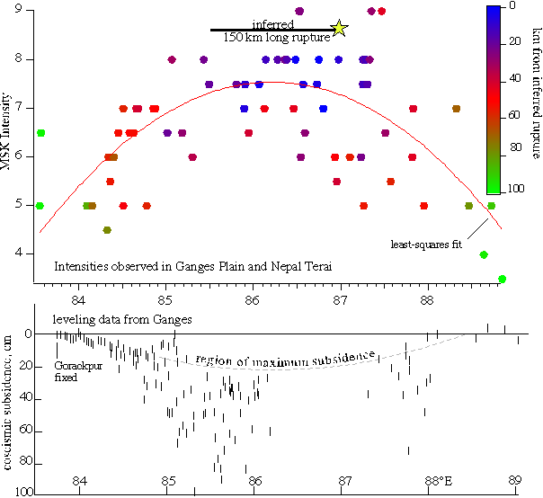
MSK intensity and bench-mark subsidence in northern India plotted versus longitude, compared to the epicentre determined by Chen and Molnar (1977). The 150-km line to its east is inferred to represent the most likely location for the rupture zone. The curve is least-squares fit of intensity is centered on this line, which corresponds to the region of maximum bench mark subsidence.
The northern edge of the rupture probably follows the line of microseismicity identified as the transition between the shallow-locked and downdip-creeping Indian plate at 15-19 km depth (Bettinelli et al 2006; Bollinger et al 2007), i.e. the locking line of Feldl and Bilham (2006). The southern edge reached the frontal thrusts near 86 deg east (Sapkota et al 2011).
Thus the inferred rupture geometry given the above numerous qualifications of uncertainty, are approximately as follows
| corner | lat deg | long deg | depth,km |
|---|---|---|---|
| SE | 26.7 | 86.8 | 0 |
| SW | 27.1 | 85.3 | 0 |
| NW | 28.0 | 85.6 | 18 |
| NE | 27.5 | 87.1 | 18 |
Length 150 km (uncertainty 25 km)
Width 100 km (uncertainty 20 km)
Slip 4-6 m, 8<Mw8.2
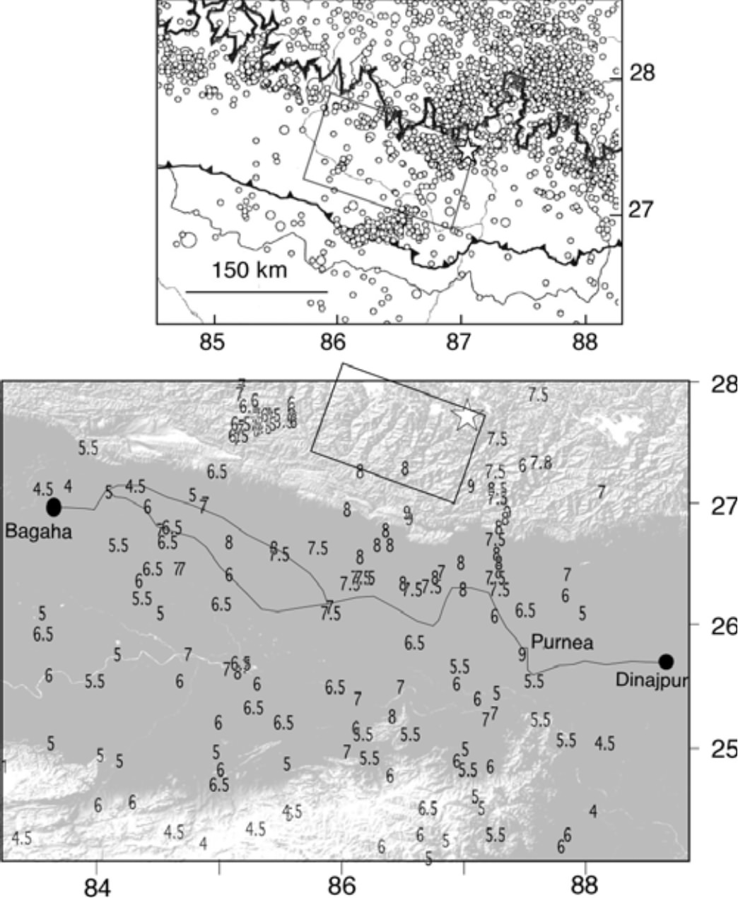 Seismicity (from Avouac 2003), MSK intensities and inferred rupture for the 1934 Nepal/Bihar earthquake. Liquefaction occurrences have been ignored in this plot. Star indicates Chen and Molnar (1989) epicenter. The microseismicity in southern Nepal between 86 deg E and 87 deg E are mostly aftershocks of the deep Udaypur 1988 earthquake. Our preferred rupture is not well constrained but its SW corner corresponds to a change in strike of the Himalayan front from N110E to N90E near 87 deg E.The Bihar leveling lines (lower figure) show subsidence between Bagaha (Goruckpur) and Dinajpur (see earlier figure).
Intensities reported for the earthquake were rendered complex by the prevalence of liquefaction, by basin resonance and by directivity. These effects are discussed in detail by Hough and Bilham (2008). Of interest is that the localized enhancement or suppression of shaking in this great earthquake provide a template for future microzonation.
Liquefaction studies using trench excavations at locations known to have suffered liquefaction in 1934 (Sukhija et al., 2002) . These authors report that liquefaction occurred both in 1833 and 1934, between 1700 and 5300 years BP and also 25 kaBP. It is unlikely that these are the only times that the area was shaken and further similar studies are likely to be of great value.
Bibliography
Ambraseys N 2000 Reappraisal of north-Indian earthquakes at the turn of the 20th Century; Curr. Sci. 79 1237-1250.
Ambraseys N and Douglas J 2004 Magnitude calibration of north Indian earthquakes; Geophys. J. Int. 159(1) 165-206, doi:10.1111/J.1365-246X.2004.02323.
Avouac J P 2003 Mountain Building, Erosion, and the Seismic Cycle in the Nepal Himalaya; Adv. Geophys. 46 10.1016/S0065-2687(03)46001-9.
Bettinelli P, Avouac J-P, Flouzat M, Jouanne F, Bollinger L, Willis P and Chitrakar G R 2006 Plate motion of India and interseismic strain in the Nepal Himalaya from GPS and DORIS measurements; J. Geod. doi:10.1007/s00190- 006-0030-3.
Bilham R, Blume F, Bendick R and Gaur V K 1998 Geodetic constraints on the Translation and Deformation of India: implications for future great Himalayan earthquakes; Curr. Sci. 74(3) 213-229.
Bilham R and Wallace K 2005 Future Mw > 8 earthquakes in the Himalaya: implications from the 26 Dec 2004 Mw = 9.0 earthquake on India’s eastern plate margin; Geol. Surv. India Spec. Publ. 85 1-14.
Bilham, R., Gaur, V. K. and Molnar, P., Science, 2001, 293,
1442-1444.
Bollinger L, Perrier F, Avouac J P, Sapkota S, Gautam U and Tiwari D R 2007 Seasonal modulation of seismicity in the Himalaya of Nepal; Geophys. Res. Lett. 34 L08304, doi:10.1029/2006GL029192.
Bomford G 1937 Leveling in Bengal and Bihar 93-97. In: Survey of India Geodetic Report 1936, (eds)
Burrard S 1934 Ground levels in Bihar in relation to the earthquake of January 15, 1934; Nature(London) 133 582-583.
Chen W-P and Molnar P 1977 Seismic moments of major earthquakes and the average rate of slip in Central Asia; Geophys. Res. 82 2945-2969.
Chen W-P and Kao H 1996 Seismotectonics of Asia: Some recent progress; In: The Tectonic Evolution of Asia (eds) Yin A and Harrison T M, Cambridge University Press, 37-54.
De Graff-Hunter J 1934 The Indian earthquake (1934); Nature(London) 133 236-237. Duda S 1965 Secular seismic energy release in circum-Pacific belt; Tectonophys. 2 409-452.
Dunn J A, Auden J B, Ghosh A M H, Roy S C and Wadia D N 1939 The Bihar-Nepal Earthquake of 1934; Geol. Surv. India Memoir. 73 1-391.
Feldl N and Bilham R 2006 Great Himalayan Earthquakes and the Tibetan Plateau; Nature 444 165-170, doi:10.1038/nature05199.
Brett,W.B. 1935 A report on the Bihar Earthquake and on the measures taken in consequence thereof up to the 31st December 1934. , Relief Commissioner, Bihar and Orissa. Superintendent, Government Printing, Bihar and Orissa, Patna, 1935.
Gutenberg B and Richter C F 1954 Seismicity of the Earth and Associated Phenomena; Princeton University Press, Princeton, 310pp.
Hough, S., and R. Bilham, (2008). Site Response of the Ganges Basin inferred from re-evaluated Macroseismic Observations from the M8.1 Shillong 1897, M7.8 Kangra 1905 and 1934 Nepal M8.1 earthquakes. Journal of Earth System Science. 117, S2, 773-782
Nandy D R, Choudhury A K, Chakraborty C and Narula P L 1993 Geological Survey of India, Bihar-Nepal earthquake, August 20, 1988; Spec. Publ. Geol. Surv. India 31, 104 pp.79.
Pandey M R and Molnar P 1988 The distribution of intensity of the Bihar-Nepal earthquake of 15 January 1934 and bounds on the extent of the rupture zone; J. Geol. Soc. Nepal 5 22-44.
Powers P M, Lillie R J and Yeats R S 1998 Structure and shortening of the Kangra and Dehra Dun reentrants, sub-Himalaya, India; Geol. Soc. Am. Bull. 110 1010-1027.
Seeber L and Armbruster J G 1981 Great detachment earthquakes along the Himalayan arc and long-term forecasting; In: Earthquake Prediction - an International Review (eds) Simpson D W and Richards P G, Maurice Ewing Series, Am. Geophys. U. 4 259-277.
Singh D D and Gupta H K 1980 Source dynamics of two great earthquakes of the Indian subcontinent; the Bihar- Nepal earthquake of January 15, 1934 and the Quetta earthquake of May 30, 1935; Bull. Seismol. Soc. Am. 70(3) 757-773.
Sukhija, B. S., M. N. Rao, D. V. Reddy, P. Nagabhushanam, Devender Kumar, B. V. Lakshmi and Pankaj Sharma, Palaeoliquefaction evidence of prehistoric large/great earthquakes in North Bihar, India, Currentn Science, 83(8) 1019-1025.
Sapkota, S.; Tapponnier, P.; Bollinger, L.; Klinger, Y.; Gaudemer, Y.; Tiwari, D. R.; Siwakoti, I.; Rizza, M.Surface Rupture of the Mw ≈ 8.1, 1934, Bihar Nepal Earthquake AGU abstract 2011
Wu F, Sheehan A, Huang G C and Monsalve G 2003 Source mechanisms, seismicity, and velocity structures in the Himalayan region; Indo-US Workshop on Seismicity and Geodynamics 49 Hyderabad.
Yeats R S, Nakata T, Faraj A, Fort M, Mirza M A, Pandey M R and Stein R S 1992 The Himalayan frontal fault system; Ann. Tect. 6 85-98.