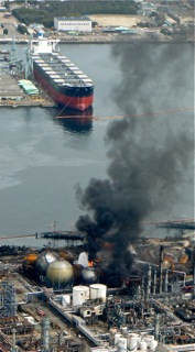
 An LPG refinery on fire 15 March as a result of ground liquefaction and fissuring near the harbor.
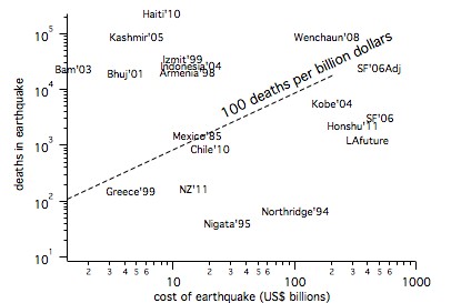
At a recovery cost estimated to exceed $300billion, the Honshu Mw=9 earthquake is by far the most costly earthquake ever to have occurred. The death toll as of 2 April exceeded 12,157 (may exceed 30,000) largely due to the tsunami whose amplitude overwhelmed coastal defences.
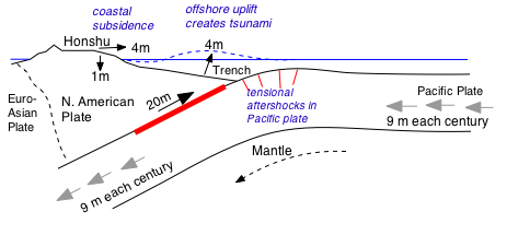
West to East section through the Honshu coastline showing location of the main rupture ending close to the shore at 30-40 km depth. The main rupture resulted in coastal subsidence (drowning the pre-earthquake shoreline by up to 1 m) and undersea uplift (creating the tsunami). [Click on figures for pdf's]
Eastward expansion of Honshu
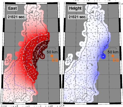
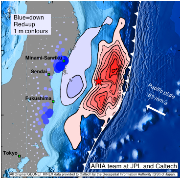
East and down contours of the earthquake (left), and calculated vertical sea floor deformation responsible for the tsunami (right, from Aria/JPL/Caltech, contours in m). More than 1200 continuous operating GPS units sampled displacements of the epicentral region at 1 second increments during the earthquake. Movies (large files!) show that the 4 m of eastward expansion, and 1 m coastal subsidence, of Honshu occurred in less than 3 minutes, and was accompanied by the passage of 50-100 km wavelength surface waves. The eastward expansion was equivalent in area to 150 soccer fields.
Subduction zone segmentation
The great earthquakes that accompany incremental slip of plates into the Earth's mantle occur on segments that may rupture singly or in combination. In the past several hundred years relatively small segments have slipped sequentially in damaging earthquakes along the Japan trench. In March 2011 several segments slipped simultaneously, something that may not have occurred here for a thousand years. An earthquake on 13 July 869 AD resembled the 2011 event in that its tsunami also flooded the coastal plains near Sendai.
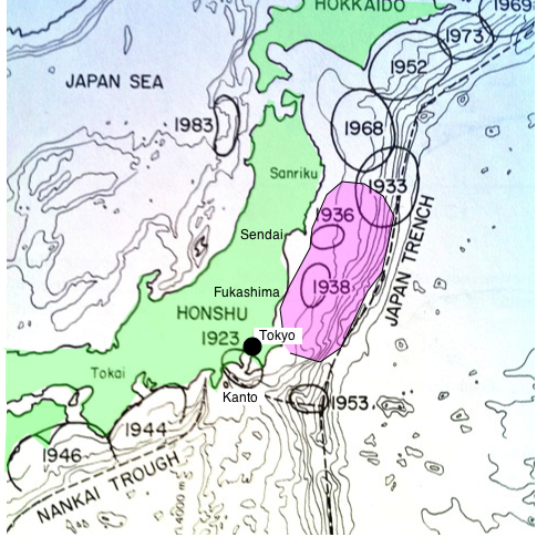
The earthquake, like historical mega-earthquakes in northern Honshu and Hokaido, released slip that had been developing over many centuries between previous rupture zones [Schwartz, 1999, Nanayama et al 2003; Satake and Atwater,2007].
The figure illustrates historical rupture zones prior to 1982 (after Mogi) and in violet the 400x150 square km segment of the plate boundary that slipped 2-30 m on 11/3/11 and in aftershocks. Until the recognition that parts of the plate boundary slipped silently without earthquakes it appeared possible to point to regions where earthquakes were overdue, by simply searching for gaps that had not slipped for many years. But because some patches of the plate boundary slip aseismically (slow and silent earthquakes) means that this simple view is no longer tenable. The mapping of the ruture areas of slow earthquakes is possible using GPS and strain measurements, and they may be recognized historically from the tsunami they produce. Thus, although Japanese scientists are potentially able to map seismic slip deficits into the future, the historical record is insufficiently complete to examine previous sequences of large earthquakes with the view to searching for future patterns.
How has this affected the predicted Tokai earthquake?
Aftershocks from the 11/3/11 Tohuko earthquake migrated south, some within 50 km of downtown Tokyo, and to the south near the forecast Mw=8.4 Tokai earthquake region. The possibility that the three Nankai segments SE of Tokyo could fail in a single earthquake has hitherto been considered unlikely. Should a single earthquake prevail its magnitude could match the recent mega-quake.
Foreshocks and aftershocks
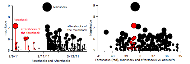
Several foreshocks occurred near the epicenter of the mainshock but at the time, these were not recognized as precursory to the mainshock sequence. Click on image for updates. Aftershocks to 9 April.
Global sea level and length of day
Large subduction zone earthquakes change the geometry of the Earth slightly. The rise in sea floor in the Honshu earthquake raised sea level globally by 0.2 mm (0.16 mm for the M8.8 2010 Chile earthquake). Calculations based on the ocean floor mass shift suggest a 1.8 microsecond shortening of the length of the day (R. Gross, JPL).
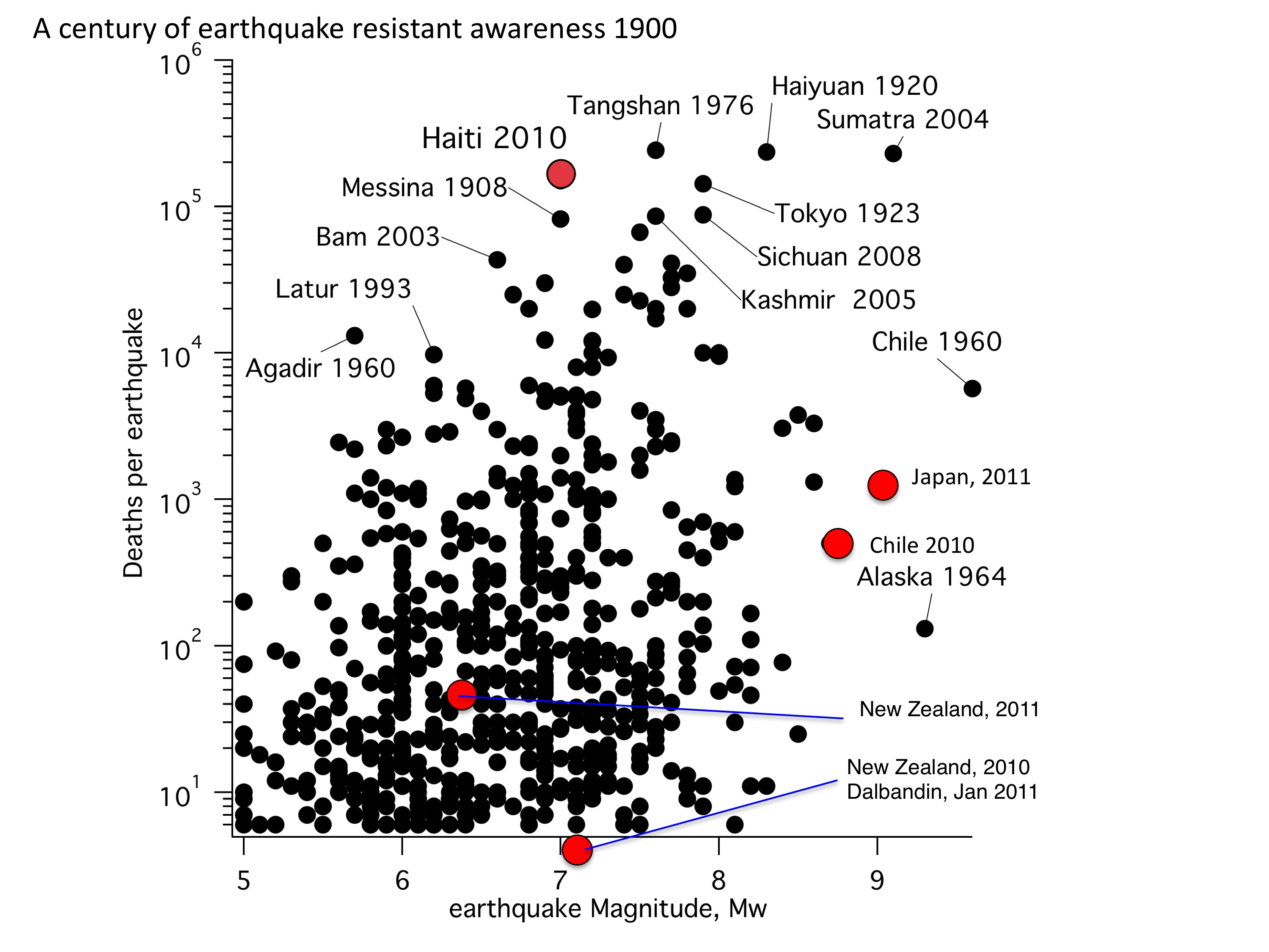
World's largest recorded earthquakes
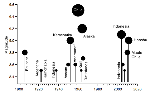
The Honshu earthquake is one of 5 earthquakes in the world to have exceeded Mw=8.4 since 2004. Initial estimates of its magnitude (Mw=8.9) have now been superceded by its Mw=9.0 status. The recent 5 mega-quakes were preceded by a four decade gap that followed a cluster of megaquakes between 1950 and 1964. No significance to the gap has been established although there appears to have been a reduction in global energy release after the 1960 cluster (see figure). Few earthquakes prior to 1900 can be assigned magnitudes due to the absence of seismometers prior to 1887. For earlier earthquakes magnitudes can be occasionally estimated from numerical data inferred from the tsunami they have produced ( 1700 Cascadia [Satake and Atwater, 2007] and 1881 Nicobar Islands [Ortiz and Bilham,2003]), or from the submarine slides they have induced (Goldfinger et al.2009), and occasionally from quanitifed surface deformation e.g. AD365 Crete [Shaw et al., 2008],.
Japan's nuclear power stations and earthquakes
The Fukushima Nuclear reactor successfully shut down in the Mw=9 earthquake. This must be considered a success, because shaking intensities were apparently close to Mercalli Intensity VII. Thirty minutes later a tsunami flooded the control buildings. In hindsight it appears impossible to believe that nuclear power stations were located on a shoreline without recognizing the engineering difficulties attending prolonged immersion by a large tsunami. In 1896 a 33 m high tsunami drowned the Sanriku coastline 200 km to the north of Fukushima. A 23 m wave surged on the same coast in 1933, and in 1993 a 30 m wave swept over Okushira Island. The Fukushima plant was protected by a 5.7 m tsunami barrier but the wave height here apparently exceeded 10 m, flooding the generators and electrical wiring in the basement and lower levels of the power plant. Nuclear power plants are simply not designed to be immersed in sea water. One can only imagine that if the concept had been aired, it had been dismissed as an unlikely occurrence in the design life of the reactor.
In 2004 Prof. Kiyoo Mogi reminded planning authorities of the dangers to epicentral nuclear power plants.
"Although the possibility of the occurrence of a great shallow earthquake in the Tokai region was pointed out by the Coordinating Committee for Earthquake Prediction in 1970, soon after, plans for construction of a nuclear power plant started in this region. Since 1976, Hamaoka nuclear power plants (Units 1-4) have been operating near the center of the expected focal region of the great Tokai earthquake, and Unit 5 is under construction. This is quite a dangerous situation."
References
Goldfinger C, Nelson CH, Morey A, Johnson JE, Gutierrez-Pastor J, Eriksson AT, Karabanov E, Patton J, Gracia E, Enkin R, Dallimore A, Dunhill G, Vallier T, The Shipboard Scientific Parties (2009) Turbidite event history: methods and implications for Holocene paleoseismicity of the Cascadia subduction zone. US Geological Survey Professional Paper 1661-F
Mogi, K., 2004, Two grave issues concerning the expected Tokai Earthquake. Earth, Planets and Space, 56, li-lxvi.
Nanayama et al., 2003. Unusually large earthquakes inferred from tsunami deposits along the Kuril Trench, Nature, 424, 660-663.
Ortiz M and Bilham R. 2003. Source area and rupture parameters of the 31 December 1881 Mw=7.9 Car Nicobar earthquake estimated from tsunamis recorded in the Bay of Bengal. J. Geophys. Res. 108: 2215, doi: 10.1029/2002JB001941
Schwartz, S., Noncharacteristic behavior and complex recurrence of large subduction zone earthqyakes, J. Geophys. Res., 104, 23111-23125, 1999.
Shaw et al. Nature Geosci. 1, 268–276 (2008).