Coseismic GPS vectors and sea level datum changes in the Andaman/Nicobar region
Recently processed coseismic data (CESS, Anil Earnest and CP Rajendrum) reveal WSW slip of the islands of the archipelago by 2.21 to 5.63 m. The points were measured serendipitously two of months prior to the earthquake. In the figure below these CESS data are merged with inferred sea level datum changes (Seism. Res. Lett. 2005) to obtain a mutually consistent displacement solution. 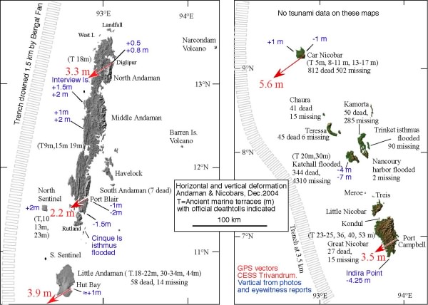 The location of the trench is uncertain to ≈20 km in places because it is filled with sediment from the Bengal Fan. Note the 30 degree change in strike between the Andaman and Nicobar groups. Maximum surface GPS displacement is reported from Car Nicobar, consistent with 12 m of slip on a 20 degree, 105-km-long planar surface. Observations on Car Nicobar (9 degrees north) shown as circles. The red and green lines indicate sythetic deformation from
Slip in the Nicobar Islands is almost normal to the trench whereas slip in the Andaman Islands appears to have been parallel to the interseismic convergence vector (Paul et al., 2001) and 40 degrees oblique to the trench, indicating that strain partitioning is not operative north of the Andaman spreading center.
Point displacements measured by the Survey of India have not yet been published.