
Nepal GPS studies
The map shows the location of GPS points installed in the Nepal Himalaya (central white box) in relation to measurements undertaken elsewhere in collaborative projects with Chinese and Indian investigators. A network of points is currently being developed by Jeff Freymueller in southern and eastern Tibet. The Himalaya are the result of an ongoing collision between India and Asia.
Slip vectors in the past 5 years indicate convergence between southern Tibet and India at 22±3 mm/year at a depth of 15-18 km beneath the Great Himalaya. Slip is directed approimately normal to the arc. The largest surface slip vectors on the plot below are 18 mm/year relative to India which is held fixed. In fact India moves NE at 58 mm/year and southern Tibet moves NE at 36 mm/year. The curved line indicates the locus of maximum contractive strain and maximum uplift. Red arrows are slip vectors of recent moderate earthquakes. The red line represents the path of a leveling line between India and Tibet.

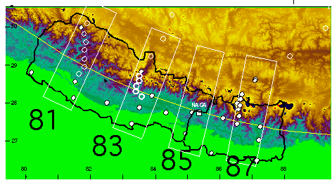
Our current projects involve installing dense arrays of points across the Himalaya that link to points in southern Tibet installed by Jeff Freymueller at the University of Alaska. We maintain two permanent GPS receivers in each of the 81, 85 and 87 degree cross-sections. Point spacings of as little as 10 km are selected for episodic occupation. Remeasurement of these points are undertaken on foot because no roads exist in the region of maximum deformation. The arrays are designed to locate the position and depth of the point where India starts to creep beneath the Himalaya. This is believed to represent the northernmost limit of great ruptures in the Himalaya.
Height of Mount Everest
Several elevations have been published for Mt Everest. The most reliable are the following:

Of the several measurements of Everest the most recent involve GPS or combinations of GPS and traditional observations. The uncertain elevation of sea level projected beneath the Himalaya makes its height currently uncertain to a few feet. Also, the unknown thickness of ice on the summit renders the elevation of the rock summit uncertain. GPS measurements on the rock exposed on the South Col of Everest (conducted by teams funded by Brad Washburn of the Boston Museum of Science) and nearby in the Himalaya indicate that the Greater Himalaya are rising at 3±2 mm/year at present. This means that Everest may be more than 1 foot higher than when it was first discovered. However, it is not known what happened to the height of the mountain during the 1934 Bihar/Nepal earthquake. The epicenter of this M=8.1 earthquake was approximately 20 km south of the mountain, which could have risen or sunk as a result of the event.
References
Bilham, R., Mountain metrology and space geodesy, Appalachia, 47, 187, 79-107, Dec 1988.
Bilham. R, Winester, D., J. Fried, B. Bernard, L. Shrestha, B.N. Shrestha, G. Adiga, and J. Faller, Absolute gravity at Nagarkot Geodetic Observatory, Archives of His Majesty's Government of Nepal, Survey Department, 1-30, 1990
Jackson, M., S. Barrientos, R. Bilham, D. Kyestha, and B. Shrestha, Localized deformation in the Nepal Himalaya revealed by spirit leveling, Geophys. Res. Lett., 19, 1539-1542, 1992.
Jackson, M., and R. Bilham, Constraints on Himalayan Deformation inferred from Vertical Velocity Fields in Nepal and Tibet, J. Geophys. Res., 99(B7), 13897-13912, 1994
Jackson, M. and R. Bilham, Epoch GPS measurements across the Nepal Himalaya, Geophysical Research Letters, 21(12), 1169-1172, 1994.
Bilham, R., The Next Great Earthquake in the Nepal Himalaya, Himal Magazine, 7(3), 26-30, 1994
Bilham, R., P. Bodin, M. Jackson, Entertaining a Great Earthquake in Western Nepal:Historic Activity and Geodetic Tests for the Development of Strain, J. Geol.Soc. Nepal, 11, 73-88, 1995.
Bilham, R., Location and magnitude of the 1833 Nepal earthquake and its relation to the rupture zones of contiguous great Himalayan earthquakes, Current Science, 69(2), 155-187, 25 July 1995.
Bilham, R., K. Larson, J. Freymueller and Project Idylhim members, GPS measurements of present-day convergence across the Nepal Himalaya, Nature(Lond)., 386, 61-64 1997.
Bilham, R., The elusive height of Mount Everest. in
Everest, 26-27, National Geographic Society, 1997