Mw=7.8 Earthquake Central Nepal (25 April 2015)
The earthquake occurred at 12:11 Kathmandu (lunch hour) and resulted in considerable damage in the city and throughout central Nepal. The earthquake was anticipated in the early 1990's (Bilham, 1994; Bilham et al., 1995) prior to the availability of numerical values quantifying Himalayan convergence (Bilham et al., 1997) and at that time it was uncertain whether shallow creep on the 6 degree north dipping Himalayan decollement might be releasing some of the accumulating compressive stress. Since then, numerous investigators (e.g. Ader et al., 2012; Sapkota et al., 2013; Bollinger et al., 2015) have confirmed the convergence rate and demonstrated that creep on the decollement south of the Himalaya does not occur. The strain energy that drives future earthquakes develops entirely along a locking line near the Greater Himalaya just south of the border between Nepal and Tibet, and is marked by a zone of microearthquakes. This locking line defines the transition region between the Indian plate descending aseismically beneath southern Tibet at 18mm/yr, and the locked decollement to the south that slips only in major earthquakes.
A striking feature of the 2015 earthquake is that rupture occurred on the Main Himalayan Thrust centered on this locking line from west to east tapping roughly 180 years of elastic energy stored there. Insar data reveal that displacement of the surface above the decollement locally exceeded 7 m (and has shifted the Nepal/Tibetan border roughly 5 cm to the south). Roughly 10 cm of afterslip occurred north of the rupture in the 3-6 months following the earthquke with a minor amount to the south.
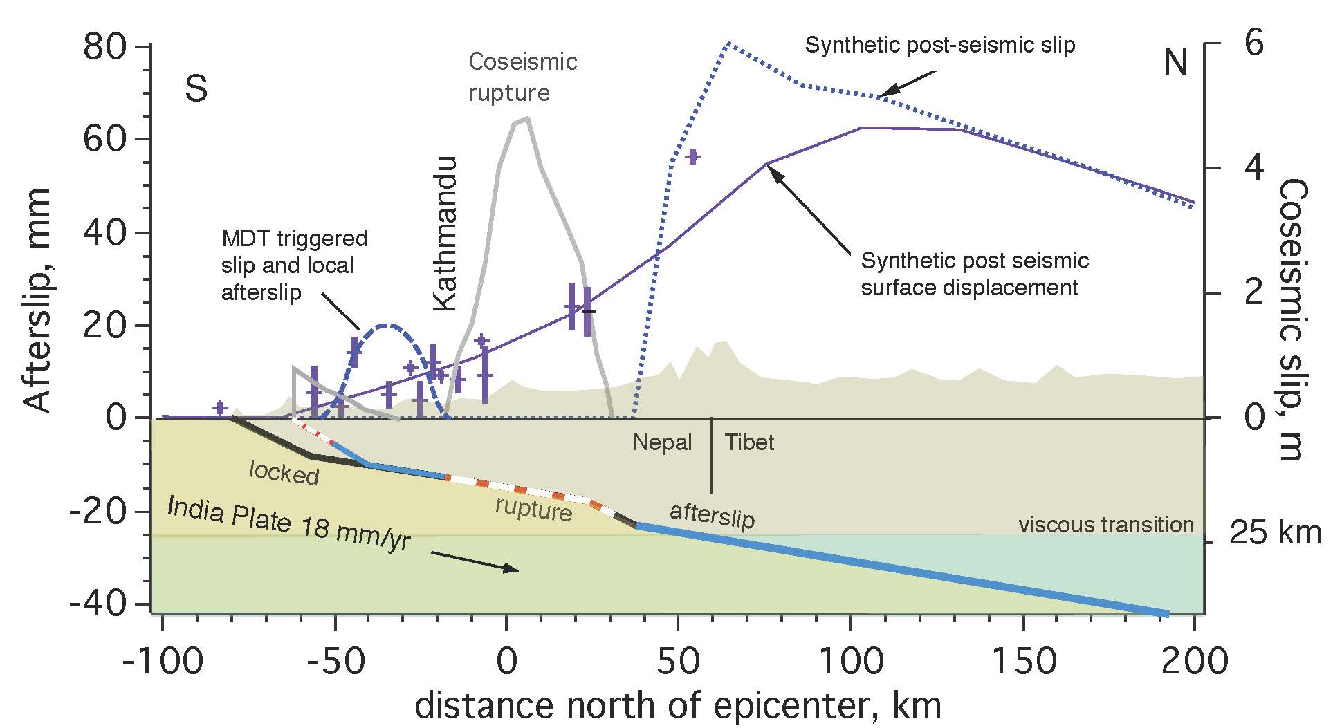
(Above- click for pdf)) North-to-south cross-section of the earthquake. The region above the red and white dahsed line slipped up to 7 m displacing the boundary between Nepal and Tibet decimeters southward.
A second striking feature of the earthquake is the absence of slip on the main frontal thrust faults (MFT) in the northern Terai plains of Nepal. Approximately 5 cm of slip was triggered on the Main Dun Thrust north of the MFT, and a few tens of mm of afterslip continued between here and the southern edge of the rupture at decaying rates for three months following the mainshock. Slip to the south is less than 2% of the slip in the mainshock. Slip on the frontal thrust is essential for India to increment northward beneath the Himalaya, and is known to accompany all great Himalayan earthquakes. A pair of earthquakes in 1255 and 1344 resulted in 3-5 m of incremental slip on this thrust fault, and the same fault was reactivated in the 1934 Mw=8.4 Bihar-Nepal earthquake (Bollinger et al., 2015). The absence of surface slip argues against the 2015 earthquake being a replica of the 1344 earthquake, and consequently being smaller in magnitude than this previous event.
There are compelling resemblances between the 25 April 2015 earthquake and a Mw=7.7 earthquake that destroyed Kathmandu in 1833. Although much uncertainty about the rupture zone of the 1833 earthquake exists due to the occurrence of three major earthquakes with increasing severity within several hours, as in the recent earthquake damage in 1833 occurred to villages both to the west and to the east of Kathmandu and in Tibetan villages north of the border. Maximum slip in the present earthquake is about 3.5 m, almost exactly the accumulated 180 year slip deficit following the 1833 earthquake. No slip was reported on the frontal thrusts in 1833.
Of great concern is the possibility that the 25 April earthquake may be a foreshock to the anticipated 8<Mw<8.4 earthquake that historical data suggest the region is capable of sustaining. Arguments for such triggering include the observation that 10% of all great earthquakes have historically been preceded by a major foreshock (Jones and Molnar, 1986), however, a previous Mw=7.8 earthquake in the Himalaya (Kangra 1905) was not followed by a larger earthquake, and neither was the 1833 earthquake north of Kathmandu (an exception is a poorly described earthquake that shook the city in 1866). Two examples do not constitute a strong case for abandoning caution, and arguments for the presence of strain sufficient to drive a great earthquake relate to the uncertain westward termination of the 6 June 1505 rupture, which is believed to have destroyed monasteries in southern Tibet over a 650 km length of the Himalaya from central Nepal westward (Bilham and Ambraseys, 2004). Since this earthquake occurred 500 years ago we know that its slip potential now exceeds 10 m, although slip in 1505 exceeded 20 m suggesting that the 1505 earthquake should not recur for many hundreds of years. However, the western end of this rupture is uncertain, and a gap may remain between and south of the 25 April 2015 rupture that could sustain a Mw.8 earthquake.
Fatalities
The death-toll from collapsed buildings and landslides was estimated 2 June to exceed 9500, almost precisely that anticipated by the USGS shakemap estimates. Prof. Max Wyss estimated a much larger fatality count. His recent estimate matches one made a decade ago based on forecasts from current convergence rates and historical slip. Had the earthquake occurred at night 12 hours earlier or 12 hours later when people were in their homes, the death toll would have been much higher.
Earthquake details
The rupture occurred at the base of the Himalaya as a pure thrust earthquake with local maximum slip of about 7m. The moment tensor analysis by Gavin Hayes, USGS (Golden Colorado) indicates that maximum slip of 3 m on a 120 km x 50 km rupture plane occurred with slip to the south (violet) and north (red) of the epicenter. The location of the earthquake is similar to that of the the 1833 earthquake (some uncertainty exists in the precise location of the three 1833 events). Given current GPS convergence rates of 18 mm/yr the 1833 rupture(s) have been restressed in the intervening 180 years by 3.3 m. The 2015 earthquake may thus be a repeat of the 1833 earthquake.
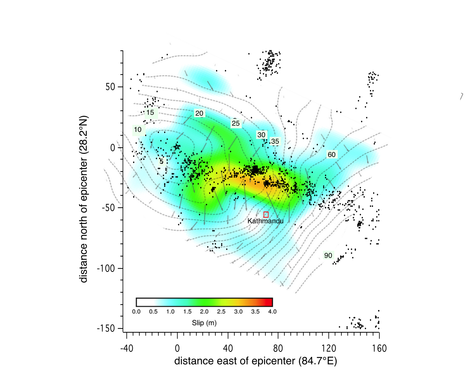
Map views showing Gavin Hayes' slip distribution calculated from mainshock seismic seismic wave. Above shows that the rupture front traveled 90 km from the epicenter at 2.5 km/s towards Kathmandu, arriving at the western outskirts of the valley 35 s after the mainshock. There it slowed to 1 km/s as it ruptured 10 km beneath Kathmandu eastwards. Strong motion data and GPS high rate sampled data (5Hz) in the Kathmandu Valley indicate that in less than 5s the city was heaved upwards by 60 cm, and 1.5 m to the SSW, at velocities of up to 50 cm/s. In the following 60 seconds valley sediments oscillated laterally at 4 s period and 20-50 cm amplitude resulting in local lateral-spreading (fissured ground near the airport), and causing pedestrians difficulty in standing. A movie of their difficulties synchronized to ground motion in Kathmandu is available here. All pre-earthquake horizontal surfaces are now tilted down to the SSW, but by less than 1 degree.

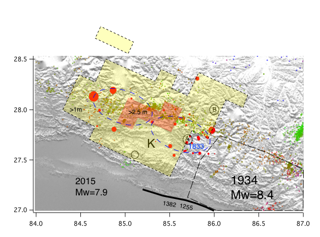
View above shows early aftershocks (red circles in first 24 hours), and nearby historical ruptures. K=Kathmandu valley. Two weakly defined locations (ellipsii) are shown for the 1833 earthquake. Maximum slip occurred close to the locking line defined by interseismic microseismicity, but slip of 1 m also propagated to the north and to the south. The black line lower right indicates the surface rupture of the 1255, 1344 and 1934 earthquakes (from Bollinger et al., 2012). These authors have suggested that the geometry and magnitude relationship of the 1255/1344 earthquake sequence resembles the present sequence 1934/2015, however, the current absence of a surface rupture makes this parallel inconclusive.
The absence of surface slip and clear evidence for the rupture terminating near Kathmandu suggests that the decollement south of Kathmandu may be stressed and creeping. GPS measurements have been implemented to test this possibility. The 1835 and1866 earthquakes that damaged Kathmandu after the 1833 earthquake may have released similar stresses seismically.
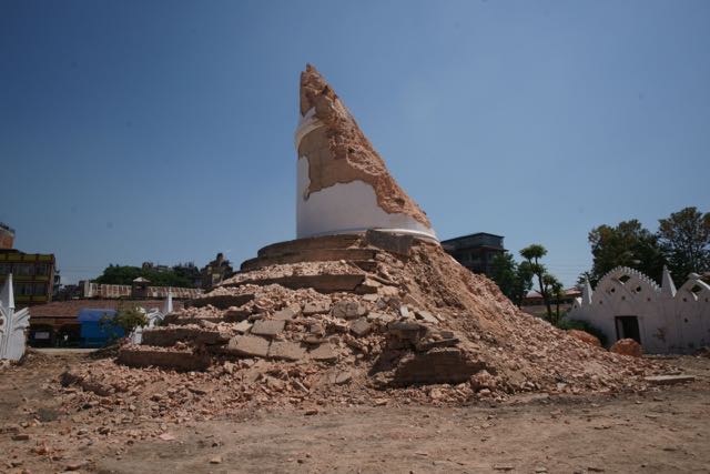
Loosing a Kathmandu icon - for the third time
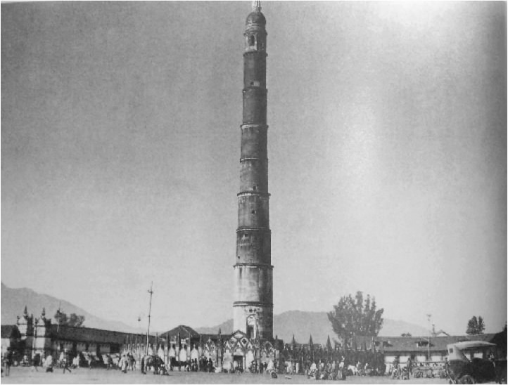
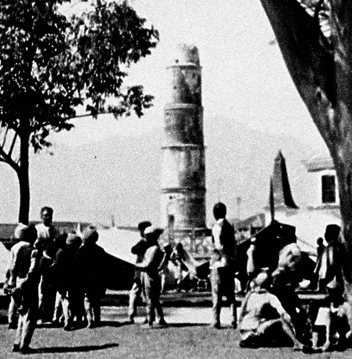
The Bhim Sen tower, (one of two) was constructed in 1825 and reconstructed after the 1833 earthquake and escaped damage in 1866. It partly collapsed in the 1934 Bihar/Nepal earthquake and was again repaired, but totally collapsed in 2015. The photos below show the Bhim Sen tower before and after 1934, and finally the ruins of its base after the 25 April 2015 earthquake. The Bhim Sen tower was most recently known as the Dharahara tower.

Where next?
A future larger earthquake is anticipated west of Kathmandu (the question mark in the figure below), but its timing is unknown. Indian Kashmir is sufficiently stressed to host one or more Mw8 or greater earthquakes (Mmax=8.9). (Schiffman et al., 2012). Similarly, Himalayan segments in Sikkim, Bhutan and Arunachal have not sustained rupture for many hundreds of years and GPS data confirm the development of a significant slip potential (Drukpa et al., 2013; Vernante et al., 2014). The timing of these future earthquakes is uncertain, but it is possible that lessons learned from the 25 April 2015 Nepal earthquake will provide insights into the processes of seismic failure in these regions at the ends of the Himalayan arc.
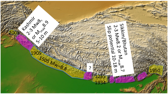
The above figure was presented at the Seismological Society of America Annual Meeting in Pasadena, Ca, 3 days before the
Nepal earthquake. A question mark near the 25 April 2015 rupture was placed there indicating uncertainty in the westward extent of future rupture, or its magnitude, facts that three days later were clarified.
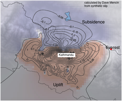
Everest shaken but height unaffected
The 25 April rupture did not get close to Mt. Everest but the elastic strain from distant rupture did. The figure shows that it lies close to the zero line of height change. If anything its height sank 1 or 2 mm in the earthquake (making it slightly less effort to climb). The Annapurna range sank more than 10 cm, and mountains north of Kathmandu sank more than 70 cm, along with the valleys between them. Height changes have reduced river gradients slightly north of Kathamandu and increased them slightly in the Kathmandu valley.
References
Ader, T., J.P. Avouac, J. Liu-Zeng, H. Lyon-Caen, L. Bollinger, J. Galetzka, J. Genrich, M. Thomas, K. Chanard, S.N. Sapkota, S. Rajaure, P. Shrestha, L. Ding, M. Flouzat (2012) Convergence rate across the Nepal Himalaya and interseismic coupling on the Main Himalayan Thrust: Implications for seismic hazard,J. Geophys. Res.,117, B04403, DOI: 10.1029/2011JB009071.
Ambraseys, N., and D. Jackson, (2003), A note on early earthquakes in northern India and southern Tibet,Current Science, 84(4), 571-582.
Bilham, R., The Next Great Earthquake in the Nepal Himalaya, Himal Magazine , 7(3), 26-30, 1994
Bilham, R., P. Bodin, M. Jackson, (1995) Entertaining a Great Earthquake in Western Nepal:Historical Activity and Geodetic Tests for the Development of Strain, J. Geol.Soc. Nepal, 11, 73-88.
Bilham R. (1995) Location and magnitude of the 1833 Nepal earthquake and its relation to the rupture zones of contiguous great Himalayan earthquakes, Current Sci., 69, 101-128
Bilham,R.,K.Larson, J.Freymueller and Project Idylhim members(1997). GPS measurements of present-day convergence across the Nepal Himalaya,Nature(Lond)., 386, 61-64 1997.
Bilham R., and N.Ambraseys Apparent Himalayan slip deficit from the summation of seismic moments for Himalayan earthquakes,1500-2000,Current Science 2004
Bollinger, L., S.N. Sapkota, P. Tapponnier, Y. Klinger, M. Rizza, J. Van der Woerd, D.R. Tiwari, R. Pandey, A. Bitri, S. Bes de Berc (2014) Estimating the return times of great Himalayan earthquakes in Eastern Nepal: evidence from the Patu and Bardibas strands of the Main Frontal Thrust, Jour. Geophys. Res., DOI: 10.1002/2014JB010970.
Feldl, N and R. Bilham, Great Himalayan Earthquakes and the Tibetan Plateau, Nature 444,165-170 (9 November 2006) | doi:10.1038/nature05199;
Jones, L. M., and P. Molnar, 1976, Frequency of foreshocks, Nature, 62, 667-679
Vernant, P., R. Bilham,W. Szeliga, D. Drupka, S. Skalita, A. Bhattacharyya,and V. K. Gaur, Clockwise Rotation of the Brahmaputra valley: tectonic convergence in the eastern Himalaya, Naga Hills and Shillong Plateau, J. Geophys. Res. 119(8), 6558A 6571, August 2014. DOI: 10.1002/2014JB011196
Sapkota, S.N., L. Bollinger, Y. Klinger, P. Tapponnier, Y. Gaudemer and D. Tiwari (2013) Primary surface ruptures of the great Himalayan earthquakes in 1934 and 1255, Nature Geoscience, 6, 71-76, doi:10.1038/ngeo1669.
Schiffman, C., B.S. Bali, W. Szeliga, and R. Bilham, Seismic slip deficit in the Kashmir Himalaya from GPS observations,Geophys.Res. Lett.,40, 5642-5645 (2013) DOI: 10.1002/2013GL057700 abstract, article and supplement.