i.e., the total vorticity divided by the depth of the fluid. For the atmosphere, the definition of the isentropic potential vorticity is very similar:
where the second factor is proportional to the inverse of the depth of an isentropic layer.
Action Items Closed February 05 from June 04
1. Prepare a proposal to support a targeted observations field experiment with a wind lidar on a G4 aircraft. - M. Hardesty, Z. Toth, E. Kalnay
Proposed, did not come to fruition.
2. . Prepare a whitepaper comparing a lidar and other wind sensors. - M. Kavaya, P. Flamant, I. Guch
Not necessary. Comparisons to date well-documented, but essentially qualitative intercomparisons. What is needed are DWL to DWL intercomparisons complete with quantitative assessment relative to performance models for the lidars.
3. A co-plot of the CTI CAMEX backscatter data and the recent GTWS 2 micron backscatter profiles is needed. - P. Gatt, D. Emmitt. E. Kalnay
CTI/CAMEX plot against Monte Carlo model (derived from GLOBE) output available from Dave Bowdle's Bar Harbor CLRC Presentation. Caveat: CAMEX does not permit to address whether background or enhanced mode has changed since GLOBE; GLAS may help address wrt to enhanced.
4. Reconvene an Executive Steering Committee to advise NASA/NOAA on actions required to implement the wind lidar roadmap. - I. Guch, D. Tratt
Planning NASA/NOAA co-sponsored spring 2005 community forum to revisit requirements.
5. The science requirements should be posted on the website. - J. Yoe
Done
6. Invite someone from the FAA to attend the next Lidar Working Group meeting - W. Baker
Done
7. Prepare a textbook on the basics of wind lidar, the advances in the past decade, and the potential benefits. D. Bowdle et al.
Gatt and Henderson manuscript in preparation is expected to cover all topics originally intended to be covered in this textbook.
8. Why are global wind profiles necessary? - E. Kalnay
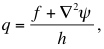
The most important dynamic property of the atmosphere is the conservation of potential vorticity for individual parcels of air. For the shallow water equations, potential vorticity is defined as
i.e., the total vorticity divided by the depth of the fluid. For the atmosphere, the definition of the isentropic potential vorticity is very similar:
where the second factor is proportional to the inverse of the depth of an isentropic layer.
Because of the conservation of potential vorticity dq/dt=0, which is strictly valid except for minor effects associated with heating and friction, the most important information that we need for a numerical weather prediction (NWP) forecast is the initial 3-dimensional field of potential vorticity. The observations that are used in data assimilation are effective in improving NWP only if they contribute to improve the accuracy of the estimated initial field of potential vorticity.
From its definition, it is clear that the variability of the potential vorticity is dominated by the relative vorticity, which can change sign and vary by more than 100% over relatively short distances (order of 1000 km), as well as in the vertical. The other terms (Coriolis parameter and fluid depth) vary much more slowly and remain with the same sign. As a result, wind profiles, from which we can derive relative vorticity much more effectively than from temperature profiles, are the paramount information needed for NWP.
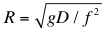
The theory of geostrophic adjustment, based on the conservation of potential vorticity, shows that for "short waves", the atmosphere "remembers" the information present in the winds, and for "long waves" it remembers the information present in mass fields (temperature or heights). However, waves are defined as short or long when compared with the Rossby radius of deformation, and it is easy to show (e.g., Kalnay, 2003, pp 186-188) that for the barotropic and the first baroclinic modes most atmospheric waves are very "short" (i.e., after geostrophic adjustment only the wind information survives). This is particularly true for the tropics, where essentially all waves are short, since the Rossby radius of deformation is defined as
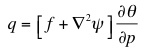
and goes to infinity at the Equator. In addition, the quasi-geostrophic balance of the atmosphere,
implies that the wind is proportional to the gradient of the mass field. As a result, the relative precision of wind measurements is larger than that of mass measurements, especially for small scales and in the tropics.
Currently we have many measurements of mass fields, such as temperatures, as for example AMSU, ATOVS and high spectral resolution IR instruments like AIRS and the soon to come IASI. These sensors are very useful away from the tropics, although wind profiles would still result in major forecast improvements. In the tropics, however, the accuracy of the temperature measurements is much less reliable than in the extratropics not only because f is small, but also because forecast errors are strongly influenced by the presence of convective instabilities. The only measurements that would allow us to reach the limits of potential predictability in the tropics are wind profiles.
Action Items Closed June 04 from January 04
1. Is a space-based DWL the appropriate technology solution for global tropospheric wind profiles? - D. Emmitt, R. Atlas, J. Yoe to prepare the answer (Action Item # 6 from January 27 - 29, 2004 meeting in Sedona, AZ; closed at the June 29 - July 1, 2004 meeting in Frisco, CO)
The requirement for global coverage can be satisfied only using a satellite-based wind sensor or sensor suite. The requirement for profiles makes Doppler lidar the appropriate wind sensor to deploy on satellites.
This is illustrated by the table below, in which the rows correspond to required wind measurement characteristics, and the columns to wind sensors and platforms. Each cell is marked Y (yes) or N (no) to indicate whether a sensor can satisfy a given requirement. Space-based Doppler wind lidar is the only sensor category that offers the possibility of satisfying all of the requirements.
SENSOR/METHOD |
DWL |
SCT |
CTW |
ACARS |
RS |
WP |
SB/AC |
AC |
|
Required Feature |
DRL |
DS |
DRL |
||||||
Global Coverage |
Y |
Y1 |
Y |
N |
N |
N |
N |
N |
|
Vertical Coverage |
Y |
N |
N |
N1 |
Y |
Y |
Y |
Y |
|
Vertical Resolution |
Y |
N |
N |
Y2 |
Y |
Y |
Y |
Y |
|
Horizontal Resolution |
Y |
Y |
Y |
Y |
Y |
N |
Y |
Y |
|
Accuracy & Precision |
Y |
Y |
N |
Y |
Y |
Y |
Y |
Y |
|
All Weather |
Y3 |
Y |
Y |
Y |
Y |
Y |
Y |
Y |
|
Frequency of Obs |
Y |
Y |
Y |
Y |
Y |
Y |
N |
Y |
|
Feasible for Ops |
Y |
Y |
Y |
Y |
Y |
Y |
N |
N |
Key:
DWL = Space-based Doppler Wind Lidar
SCT = Space-based microwave scatterometers for ocean surface winds
CTW = Cloud Track Winds inferred from a number of satellite imagers at various wavelengths
ACARS = in situ wind sensors deployed on commercial aircraft
RS = Radiosonde (weather balloons)
SB/AC = High altitude vehicles (balloons or planes) releasing dropsondes
WP = ground-based (Doppler) wind profilers, usually radar but possibly lidar
AC = Aircraft equipped with Doppler radar or lidar
Y1 Excluding over land.
Y2 Only in the vicinity of airports, however.
Y3Except below thick unbroken clouds.
N1 Except in the vicinity of airports.
2. How do we interpret multiple OSSE results? - J. Yoe, R. Atlas, D. Emmitt (Action Item # 7 from January 27 - 29, 2004 meeting in Sedona, AZ; closed at the June 29 - July 1, 2004 meeting in Frisco, CO)
Although the magnitude of the predicted impacts and even the choice of impact metrics vary considerably, all of the recent OSSEs performed at NOAA and NASA using current global and regional forecasting models show significant positive impacts from plausible DWL concepts. The varying results are essentially a result of the different techniques used in simulating existing and proposed observing systems and in assimilating the simulated data products.
3. How do we ensure the NWP centers are ready to use wind profiles when they become available? - D. Emmitt, J. Yoe, W. Baker (Action Item # 8 from January 27 - 29, 2004 meeting in Sedona, AZ; closed at the June 29 - July 1, 2004 meeting in Frisco, CO)
The OSSEs are not only useful for establishing data requirements and evaluating DWL instrument/mission concepts. Completion of a wind OSSE requires that the algorithms, techniques, codes, and experience for assimilating real, high quality wind observations be prepared well before the launch of the instrument that will deliver them.
To promote a successful and expedient transition to operations, it is important to support and sustain the OSSE efforts in environments closely linked to the operational NWP centers. To ensure that sufficient resources are devoted to making the transition to operations, directors of the NWP centers must be informed of the expected value of the data and of mission prospects and schedules.
4. DWL FAQs should be sent to I. Guch for posting on the website.
All (Action Item # 9 from January 27 - 29, 2004 meeting in Sedona, AZ; closed at the June 29 - July 1, 2004 meeting in Frisco, CO)