Wayman Baker opened the 27th meeting of the Working Group on Space-Based Lidar Winds (LWG) with introductory remarks and a review of Action Items from previous meetings.
The meeting purpose was to review advances in atmospheric science and lidar technology toward a capability to measure the global wind field from space. Since 1994, the LWG has met twice yearly to bring together potential Doppler Wind Lidar (DWL) data users and technologists, including international representatives, to exchange information, review the latest technology developments, and build a consensus for space missions.
Excellent progress continues in technology, instrument architecture, mission concepts, benefit studies, field demonstrations, and other areas. Interagency support for a hybrid demonstration is building. The recent National Academy of Sciences (NAS) decadal survey report, a recent NASA Earth-Sun System Technology Office (ESTO) study report, the U.S. Integrated Earth observing System Strategic Plan, and the National Polar-Orbiting Environmental Satellite System (NPOESS) Integrated Program Office assign high priority to global wind observations at all levels. Following the European Space Agency’s (ESA’s) Atmospheric Dynamics Mission (ADM) launch, scheduled for mid 2009, we hope to see a U.S. space demonstration of a hybrid bi-perspective DWL.
Technology readiness continues to improve. A recent ESTO conceptual design developed by the NASA Goddard Space Flight Center (GSFC) Instrument Synthesis and Analysis Laboratory (ISAL) and Integrated Mission Design Center (IMDC) for a space demonstration mission was determined to have no technological tall poles.
Ramesh Kakar and Bruce Gentry presented “Overview of the NASA Advanced Mission Concept Study for a Global Wind Observing Sounder (GWOS),” coauthored with M. Kavaya. This study was carried out by the GSFC and the Langley Research Center (LaRC) for NASA Headquarters (HQ) in cooperation with NOAA. Ramesh is NASA Program Scientist for winds and Weather Focus Area leader for the NASA HQ Science Mission Directorate. The Science Mission Directorate/Earth Science Division requested mission studies, including the GWOS mission study, in anticipation of the National Academy of Science (NAS) Decadal Survey recommendations in January 2007. The mission studies support responses to NAS recommendations and preparation of a Science Mission Plan for Congress. A winds mission has the highest priority rating from the Weather focus panel, and is important to Water Cycle and Atmospheric Composition focus panels.
Ramesh emphasized the competition within NASA for mission funding, the importance of wind mission support from outside NASA, and the need to cover gaps for instruments not included on NPOESS. He said that the 2007 Research Opportunities in Space and Earth Sciences (ROSES), to be announced on February 16, includes funds for wind lidar.
The GWOS study addressed science requirements, feasibility, conceptual designs, and cost vs. performance for NASA HQ internal planning. A follow-on task plan recommended technology and research investments. GWOS requirements address a space demonstration (pre-operational) mission, with requirements relaxed in some areas relative to operational threshold requirements. The demonstration requirements will provide significant science impact. A 400 km circular sun-synchronous orbit was recommended, with a hybrid (both direct detection and coherent detection) instrument and bi-perspective observations. The instrument will measure winds along two tracks. The study determined that hybrid detection yields higher data utility than direct or coherent detection alone. The instrument design uses key components from Geoscience Laser Altimeter System (GLAS), the Tropospheric Wind Lidar Technology Experiment (TWILiTE) Instrument Incubator Program (IIP), and the Doppler Aerosol Wind Lidar (DAWN) IIP. Fixed telescopes are shared among all lasers, eliminating the complex scanning telescopes found in conceptual designs for threshold requirements. Going from demonstration requirements to threshold requirements requires four tracks instead of two. Alternative approaches to measuring four tracks include scanning telescopes, more than four fixed telescopes, multiple spacecraft, and other technologies. Performance charts were shown to illustrate how requirements are met and the advantages of the hybrid instrument. Technology development needs include demonstration of laser lifetimes and aircraft validation flights. The demonstration instrument uses about 90% of the volume of a Delta II fairing. A technology maturity roadmap was shown to illustrate progress and funding status of steps to a mission. IIP-2004 projects are addressing compact packaging, packaged ground demo, preparation for aircraft demonstration, 0.355 micron receivers and autonomous operation. Recommended research and analysis (R&A) investments included continued OSSEs; 3D statistics of clouds, aerosols and transmittance; and air and space data collection to support algorithm development. The GWOS mission will fill a critical gap, improve forecasting skills, provide a breakthrough in instrument design, advance technology transfer, and promote Research-to-Operation partnership between NASA and NOAA. General discussions included several points: the NRC decadal survey cost estimate of $650 M for the first wind mission, the need to address societal benefits, the objective requirements to be met in subsequent missions, how to achieve resolution and coverage requirements, the use of four direct and two coherent lasers to meet lifetime requirements, and the fact that the ISAL designs are being used for internal planning and are not available for public release.
Martin Endemann presented “Concepts for Operational Aeolus Spacecrafts,” coauthored with P. Dubock. The Atmospheric Dynamics Mission (ADM) - Aeolus was selected in 1999 as an ESA Earth Observation Envelope Programme mission. It is a dedicated satellite to provide global wind profile observations for input to Numerical Weather Prediction (NWP) models. The industrial project phase started in 2002, Critical Design Review was completed in 2005, and launch is planned for mid 2009 for a three-year mission. Martin presented Aeolus wind profiling requirements and described implementation, sampling approach, and Prediction Impact of Extreme Weather (PIEW) project impact assessment. The Atmospheric Laser Doppler Instrument (ALADIN) instrument is a direct detection ultraviolet DWL with receivers for both aerosol and molecular backscatter. Aeolus will measure single perspective line of sight (LOS) wind on a single ground track from a dusk-dawn, sun-synchronous, 400 km orbit. The design powers the laser on and off repeatedly to save power, which has proven to be a development challenge. Alternative approaches were discussed to increase resolution.
PIEW impact analysis showed improvement over state-of-the-art forecasts. Measuring vector profiles instead of single LOS over the Northern Hemisphere improves forecasts by 50%. Tandem Aeolus spacecraft provide more uniform coverage and improvement of 70%. Three Aeolus give additional improvement, particularly over the North Atlantic.
Aeolus planned lifetime is 2009 through 2012 and the first post European Polar System (EPS) launch is planned for 2019. Wind profile requirements are anticipated for post EPS. The data gap between 2012 and 2019 needs to be filled. Budget limitations make it desirable to minimize design changes and improve lifetime. ESA and EADS-Astrium studied concepts for lowest cost follow-on missions. Document AE-TN-ASU-SY-00131, Issue 1 addresses 5 mission improvements: more height bins, second LOS, lifetime extension, ALADIN instrument on MetOp, and coverage improvements. Some improvements are compatible with short development times and minor cost increases. These include increasing the number of height bins, maximum altitude, and mission lifetime. Flying ALADIN on MetOp is not feasible because of mass and power requirements and the 800 km post-EPS orbital altitude. Each Aeolus spacecraft produces data roughly equivalent to all existing radio-sonde data, and ECMWF will measure impact on NWP. Orbit changes were found to be cost prohibitive. To avoid a data gap, financial commitment for long lead items is required in 2009 and for satellites in 2010. A mission model and cost estimates (580 to 700 M Euro range) were discussed. Martin concluded that it is feasible to avoid a data gap and to include minor engineering changes. Operating two satellites after mid 2014 would address PIEW findings and provide redundancy in orbit. The follow-on program is feasible with minor engineering changes.
Martin Endemann presented “Aeolus Project Status.” Martin discussed the Aeolus satellite and its ALADIN payload. Hardware manufacturing and integration are well advanced. The satellite bus is mostly integrated, and the instrument structure, thermal, and electronics hardware are all available. Launch date is June 2009. Aeolus mass is 1.1 t including fuel. The solar arrays are about 13 m wide and produce 2.2 kW. The orbital average power is 1.4 kW. The satellite can be launched with small launchers. Flight software is being tested. The 1.5 m diameter telescope dominates ALADIN’s size. 355 nm lasers are diode pumped Nd:YAG. The most difficult parts of the system are the two transmitter lasers. It is hard to operate the laser in on-off sequence, but it is necessary to turn it off to decrease power. Problems were encountered in vibration tests and some retrofits are likely. Issues include laser diode lifetime, laser-induced damage and laser-induced contamination. Star trackers are mounted on the ALADIN structure to optimize pointing reference. Testing is underway on the integrated ALADIN flight model. ALADIN mass is 480 kg and power is 830 W. Pump laser diode stacks are being life-tested for qualification. Laser induced damage and contamination are being tested. The telescope is all silicon carbide with 75 kg mass and 350 nm wavefront error. The telescope is integrated with the ALADIN structure. Transmit/Receive optics are in environmental testing. The Rayleigh spectrometer is delivered, and the Mie spectrometer is in environmental testing. A wind lidar in the DLR Falcon research plane had initial flights in Oct 2005. The airborne demonstrator transmitter laser will be refurbished to address vibration problems, and an airborne campaign is planned for September 2007. A ground-based campaign with other lidars and conventional wind sensors was completed in October 2006.
Tom Adang presented “NOAA Integrated Observation Architecture,” describing NOAA’s background, accomplishments and directions in Earth observation. Tom reviewed the complexities of large scale NOAA projects. There are many requirements and limited budgets (about $4 B). Pressure is caused by mission growth and problems. A full-scale architectural process is needed to address NOAA’s challenges. The observing and data management system planning before 2002 was in need of an architectural process that addressed observing system selection, links to needs, NOAA-wide requirements, gaps in requirements satisfaction, costs, and benefits. NOAA Program Review Recommendation 32 (August 2002) and the NOAA Strategic Plan (May 2003) recommended central planning and integration of all observing systems, and development of a NOAA-wide observing system architecture. A strategic direction was developed to provide a course for achieving NOAA goals, aligning technology to mission goals, prioritizing budget alternatives, finding cost reductions and realigning resources. NOAA observing system and data management system planning is now a structured and disciplined process driven by goals and requirements and contributing to increased societal benefits. Observing system requirements and gaps are defined, cataloged, prioritized, and accessible. Analysis capabilities are improved. Tom identified several specific results. He discussed investment recommendations for the NEXRAD Dual Polarization system, cost avoidance on solar wind observations and Coronal Mass Ejection Imager, and responding to the Decadal Survey Report. NOAA is continuing to improve integrated architecture analysis of alternatives. In the discussion period, Tom described a process to improve objective selection among alternative instruments addressing the same requirements. Selection of the best discriminators is important. It was suggested that NASA and NOAA work together to reduce combined technology development costs. OSSEs and THORPEX-like evaluations of end-to-end observation impacts were discussed as possible discriminators. It was also pointed out that DWL will affect several NASA focus areas in the decadal survey, not just weather.
Steve Mango presented “Status of NPOESS/NPP Restructured and The Potential Role of a Wind Lidar for the Next Generation NPOESS.” Steve provided an update on NPOESS planning and discussed the prospects for a future wind mission. NPOESS restructured primes and subcontractors are expected to be in place about May 2007. The budget will be constrained for five to seven years. There will be two orbits instead of three. Seven sensors are de-manifested from C1 and C2, although accommodation remains. CMIS is dropped from C1, but MIS is planned for C2 and beyond. NPOESS Preparatory Project (NPP) launch is planned for September 2009, C1 for January 2013, and C2 for 2016. There is a potential role for DWL in the next generation NPOESS. It won’t be ready in time for the first NPOESS. This is consistent with the timeframe of decadal survey recommendations. Increased international cooperation and international combinations of observing systems were discussed. NPOESS will have excellent connectivity and average latency of less than 30 minutes to complete ground processing. Wind observations cut across several of the nine societal benefit areas in Global Earth Observation System of Systems (GEOSS). IPO has allocated funds to look into next generation NPOESS. A hybrid DWL space demonstration is a possibility in 2016, followed by an operational DWL mission in 2022 or later as part of the next generation NPOESS. Ramesh Kakar pointed out the need for operational agencies to make their weather and winds needs known to NASA.
Michael Kavaya presented “Summary of Findings of the National Research Council's Decadal Survey on Earth Sciences and Applications from Space.” The National Academy of Science (NAS) study was done by a Committee on Earth Science and Applications from Space, under the Space Studies Board in the NAS Division on Engineering and Physical Sciences. The organization and committee membership were discussed. The committee reviewed status; identified top-level scientific questions in the period 2005-2015; considered users, opportunities and challenges to exploiting Earth observations from space; recommended a prioritized list of measurements, capabilities and activities within NASA ESE and NOAA NESDIS; and identified planning directions beyond 2015. The activity was sponsored by the NASA Science Mission Directorate, NOAA National Environmental Satellite, Data and Information Service, and USGS. Panels addressed Extreme Event Warning, Human Health, Weather Prediction, Climate Prediction, and Air Quality. Tropospheric wind observations were identified as important to several areas. Recommendations included 1) renew investment in Earth observing systems and restored leadership in Earth science and applications, 2) conduct 17 missions, 3) pursue technology and planning to continue useful observations, and 4) foster new space-based concepts. Among other recommendations, it was recommended that NASA SMD obtain long-term Earth observations distinct from NOAA numerical weather prediction requirements, increase support of Research and Analysis programs, create a new Venture class of low cost missions to foster innovation and train future leaders, and increase investment in research to operations. A Three-Dimensional Tropospheric Winds from Space-based Lidar mission was recommended. This mission was the highest priority mission from the Decadal Survey Panel for Weather Science and Applications. The Panel recommended a demonstration mission in the 2016 time frame followed by an operational mission as early as 2022. The Water Resources and Global Hydrologic Cycle Panel also recommended a tropospheric winds mission.
Dave Winker presented “CALIPSO: Status and Performance.” Dave discussed the Cloud-Aerosol Lidar and Infrared Pathfinder Satellite Observation (CALIPSO) mission. The mission is up and working following launch from Vandenberg AFB on April 28, 2006. The payload included Cloud Aerosol Lidar with Orthogonal Polarization (CALIOP), a Wide-Field Camera, and an Imaging Infrared Radiometer. CALIOP uses two 110 mJ Nd:YAG lasers, wavelengths 532 and 1064 nm, and a 1 m diameter telescope. CALIOP has three channels for aerosol and cloud profiling. It has a polarization insensitive 1064 nm receiver and two polarized 532 nm channels. Profiles provide information on vertical distributions of clouds and aerosols. CALIOP is meeting specifications. It is eye safe for people in aircraft and ISS. Data products were shown, including profiles from all three channels on an orbital swath, clear-air profiles, and calibration charts. The flight laser and its performance were described. Plots of CALIOP and GLAS pulse energy versus days-on-orbit trends were shown. The CALIOP lasers have maintained pulse energy levels through the more than 210 days charted. Observation illustrations were presented. Statistics from one month of night data were presented for top height of highest cloud, top height of lowest detected layer (65% of shots reached the surface), attenuated backscatter, and transmittance. Level 1 through 3 lidar data products were described and illustrated. Process studies combining CALIPSO and Aura data and a comparison of CALIPSO and CloudSat were shown.
Upendra Singh presented “Development and Risk Reduction of a 2-Micron Laser Transmitter for a Space-Based Coherent Doppler Wind Lidar System,” coauthored with M. Kavaya, J. Yu, M. Petros, B. Trieu, Y. Bai, and P. Petzar. Upendra provided an overview of progress and status at LaRC on the Laser Risk Reduction Program (LRRP), including the coherent DWL transmitter, 2 micron solid state lasers, partially conductively cooled compact laser, one Joule 2-micron laser, and conductively cooled laser development. LRRP is a joint LaRC-GSFC program, with a primary goal of reducing risk of future NASA laser/lidar space missions. LRRP began in FY02 and has already assisted the GLAS and CALIPSO missions. The requirements for a packaged transceiver for an Instrument Incubator Program (IIP) were reviewed. A 2 micron technology roadmap and progress were discussed. A 2 micron laser with one Joule per pulse has been demonstrated. The partially conductively cooled compact laser transmitter for DWL is being fabricated. A diode-pumped, fully conductively cooled 2 micron oscillator has been demonstrated.
Dave Emmitt presented “Integrating Airborne DWL and PBL Models in Real Time,” coauthored with C. O’Handley, S.A. Wood, and S. Greco. Dave discussed Twin Otter DWL (TODWL) activities, comparison of profiles from models with TODWL observations, and work for an Army-sponsored real time DWL/model validation activity. TODWL, operated out of Marina CA, has a 2 micron DWL with a scanner mounted on a Naval Postgraduate School (NPS) Twin Otter aircraft. The aircraft operates up to 10,000 ft at cruise speeds from 100 to 140 kt. It is equipped with Global Positioning System (GPS) and inertial navigation system (INS), dropsondes, aerosol probes, and sensors for temperature, water vapor, and turbulence. DWL characteristics and a smart towed package were discussed. Plans include towed platform experiments, IPO/NESDIS experiments to underfly WindSat and QuikScat, long baseline profiles for assimilation into NCEP models, and exploratory flights prospecting for Unmanned Aerial Vehicle (UAV) atmospheric advantages. TODWL soundings have been processed, and study is needed to understand differences between observations and models. MM5 model validation studies at NPS showed significant differences with observed profiles and surface winds. A phase II Small Business Innovation Research (SBIR) activity is underway (September 2006 start, two-year study) to develop an In-flight Lidar Integrated Mission Management System (I-LIMMS) with real time data visualization. Numerical models, data requirements and validation techniques were described. Field testing flights will resume in April 2007 with real time modeling support, with final demonstrations in Fall 2008.
Bruce Gentry presented “Progress on the Tropospheric Wind Lidar Technology Experiment (TWiLITE) Direct Detection Doppler Lidar IIP,” coauthored with G. Schwemmer, M. McGill, M. Hardesty, A. Brewer, T. Wilkerson, R. Atlas, M. Sirota, and S. Lindemann. The three year TWiLITE IIP is developing a high altitude airborne molecular direct detection scanning DWL for a system level demonstration. This activity is on the development path toward a space based DWL. It will measure full wind profiles from a high altitude aircraft. Measurement requirements include velocity accuracy of 2 m/s, range of regard 0 to 18 km, vertical resolution 0.25 km, groundspeed 200 m/s, nadir angle 45 degrees, scan pattern up to 16 point step-stare, and horizontal integration per line of sight (LOS) 10 s or 2 km ground track. Instrument parameters include 355 nm wavelength, 0.08 m2 telescope/scanner area, and a 25% photomultiplier tube (PMT) quantum efficiency. Results of photocount detection and LOS wind error with simulated shot noise were discussed. Specifications of the target platform, the NASA Johnson WB57, were reviewed. The WB57 has a maximum altitude of 18 km, flight duration of 6.5 h, cruise speed of 210 m/s, payload mass of 1814 kg, and three phase payload power of 4 X 25 amp at 499 Hz. The payload mounts on a 3 ft modular pallet with a nadir view. Key technologies are the laser transmitter, optical filters, photon counting technologies, and UV Holographic Optical Element (HOE) and scanning optics. The double edge etalon channels, triple aperture step etalon (Michigan Aerospace Corporation), receiver mechanical assembly, HOE design, Fibertek laser, and pallet integration concepts were discussed. A project milestone chart showed test flights scheduled for late summer 2008.
Floyd Hovis presented “Laser Transmitter for TWiLITE,” coauthored with B. Gentry. Floyd reviewed laser transmitter specifications, which include 355 nm wavelength, >30 mJ/ pulse, 200 Hz pulse repetition rate, and 1 billion shot lifetime at 1064 nm. Some specifications, including environmental, were exceeded by design performance. BalloonWinds, Raytheon, and Air Force lasers provided a basis for key design features of the laser subsystem, on which acceptance testing was completed in November 2006. The laser transmitter optical layout and laser housing design were presented. Ring oscillator performance was reviewed. Eight six-bar diode arrays are included, operated at 75 W peak power per bar, with 250 W heat dissipation. Power amplifier and third harmonic generation design (from Fibertek IR&D) were discussed. Optical-mechanical design is complete with long lead components on order. Electrical designs were previously developed for BalloonWinds and Raytheon Wind Laser transmitters. The software design is complete. Laser subsystem properties include: optics module 16 kg and 10,850 cm3, electronics 22 kg and greater than 11,000 cm3. Overall power is 470W at 28 v dc, with about 250 W in the optics module and about 200 W in electronics. Laser subsystem delivery is planned in July 2007. This work is funded by the NASA Earth Science Technology Office under the IIP.
Robert Brown presented “The Scatterometer--No Competition.” At this time, the scatterometer is not a competing wind observing instrument in the US schedule. Bob discussed the physics of scatterometer wind measurement and status of scatterometers in space. QuikSCAT, launched in 1999 is operating and MetOp’s Advanced Scatterometer (ASCAT) has been launched. Earlier scatterometers are not operating and no new ones are on the U.S. schedule, even though scatterometer data products are providing significant utility. Examples of wind and surface pressure data products from space were reviewed. Surface pressures can be estimated from surface winds. QuikSCAT surface pressure analysis improves NCEP real time forecasts. The data show:
Bob showed examples of surface pressure analysis overlaid on a GOES image for Ocean Prediction Center (OPC) analysis, QuikSCAT passes, runs of a model using QuikSCAT data, and a surface vorticity plot from the University of Washington PBL (UWPBL) model. An example compared lows from a Global Forecast System (GFS) model, QuikScat winds, OPC analysis, and UWPBL analysis. Plots of divergence and surface pressure were shown and discussed.
Dave Emmitt presented “Prospecting for Thermals Using an Airborne DWL,” coauthored with C. O’Handley. This work supports Defense Advanced Research Projects Agency (DARPA) objectives and is part of a National Institute of Aerospace and LaRC project using the Twin Otter Doppler Wind Lidar (TODWL) to study winds. TODWL is a Navy Center for Inter-Disciplinary Remotely Piloted Aircraft Studies (CIRPAS) aircraft. Flights in October 2006 searched for vertical winds near the aircraft, assessing use of autonomous location of updrafts to prolong mission duration. The approach identified vertical wind structures (thermals, downdrafts, and waves) and their extent, and ranked local structures. The lidar scanned forward of the aircraft, and results were input to a model. Photographs of the aircraft and instrument were shown. The instrument is a 2 micron coherent detection DWL with a two axis scanner mounted in the side door of the aircraft. TODWL has been operated since 2002 for the Navy, NOAA, and DoD. Plots of flight level wind velocity and signal amplitude and aerial photographs of geographical structures were discussed. Experiments assessed the use of aircraft motion to scan the lidar beam instead of using the instrument scanner. Additional flights are planned in April 2007 to sample near cloud, ridge, and valley systems. The vertical velocity measurements appear useful, the best scan techniques were continuous or random raster scans, and aerosol loading and vertical motion were correlated.
Daniel Creeden presented “Short Wave IR (SWIR) Lasers for Laser Detection and Ranging (LADAR) Applications,” coauthored with J. McCarthy, P. Ketteridge, and E. Chicklis. Daniel discussed the development of advanced materials and conduction cooled SWIR lasers including high energy and high prf solid state lasers and fiber lasers. A diode pumped Nd:YAG designator/range finder, a high prf Nd:YVO4 1064 nm laser, and an Nd:YVO4 transmitter were described. Fiber laser benefits include compact, efficient (15% wall-plug) pulse amplification, low cost, low weight, large gain-bandwidth product, pulse flexibility (variable prf, high peak power), and power scalability. Topics included a semiconductor seed oscillator, bulk vs. fiber optics techniques, an all-fiber master oscillator fiber amplifier (MOFA) with 19 W pump at 975 nm, and an all fiber configuration. The fiber techniques provide efficient high power 1064 nm pulses, wave-guided source, pulse control, scalability, and flexible architecture. Terahertz frequencies have advantages in imaging and spectroscopic applications. Fiber pumped difference frequency mixing (DFM), pump setup, THz setup, THz source, and results at 2.45 THz were discussed. Imaging examples were provided.
Eugenia Kalnay presented “Adaptive Observation Experiments with 3D-Var and Ensemble Kalman Filtering (EnKF): Implications for Intermittent Lidar Wind Observations,” coauthored with J. Liu. Eugenia addressed the question of how to allocate future DWL observations to maximize their effectiveness, and addressed the effectiveness of using 2% and 10% observation duty cycles for the DWL in space. Results were shown for various sampling strategies and for Local Ensemble Transform Kalman Filter (LETKF) and 3D-Var forecasts. LETKF is a fast algorithm and uses local observations more efficiently than 3D-Var. Ensemble spread among LETKF forecasts is used in an adaptive observation strategy, with adaptive observations located where the ensemble spread is large. Six strategies were identified for 10% observations: uniform, random, climatological, ideal, everywhere, and ensemble spread. Eugenia addressed four questions: (1) ensemble spread effectiveness in a global model, (2) impact of 10% observations instead of 100%, (3) impact of 2%, and (4) impact difference using different assimilation schemes (3D-Var vs. LETKF). For 10% adaptive observations, both 3D-Var and LETKF forecasts are much improved. LETKF is less sensitive to choice of adaptive strategies than 3D-Var. The ensemble spread observation strategy provided the largest improvement. Changing observation locations with time is better than keeping constant observation locations with 3D-Var. 10% adaptive observation with ensemble spread strategy can get more than 90% of the effect of 100% observation using 3D-Var. 2% adaptive observations are not enough for 3D-Var, but give about 90% impact in LETKF. Ensemble spread sampling strategy can give almost the same impact as the ideal sampling strategy. Dwelling on areas of forecast uncertainty based on ensemble spread should be considered in the design of any atmospheric instrument.
Amy Clement presented “20th Century Trends in Tropical Atmospheric Circulation.” Amy discussed Walker circulation and Hadley circulation. Walker circulation is an ocean thermostat mechanism. Since water vapor increases faster than precipitation with sea surface temperature, models suggest that tropical overturning circulation should weaken with increasing temperature. Different models arrive at different conclusions about trends. 20th century changes and trend plots from several different models were discussed for the Hadley cell. Graphs of solar shortwave (SW) flux, outgoing longwave radiation (OLR), linear trends in High Resolution Infrared Sounder (HIRS) OLR data and in Special Sensor Microwave Imager (SSMI) water vapor were discussed. Walker tropical atmospheric circulation across the equatorial Pacific offers clues to climate mechanisms. The ocean thermostat mechanism predicts strengthened Walker circulation, sea surface temperature data are inconclusive, and sea level pressure data suggest a weakening Walker circulation over the 20th century. A linearly decreasing tropical sea level pressure difference trend relates to decreasing circulation. Hadley circulation reanalyses show an increase in Hadley cell strength, but models do not show this trend. Observations of radiative fluxes and water vapor suggest increased subsidence in parts of the subtropics, but there is not enough time record to distinguish short term from long term trends. In the discussion, Amy said that any direct observations, including winds, will help with understanding climate, and that stable measurements are needed over a long time frame to establish trends.
Brian Soden presented “Atmospheric Circulation Changes in a Warmer Climate,” coauthored with I. Held and G. Vecchi. This activity seeks to identify climate change aspects that are consistent across models and supported by simple physical arguments. It seeks to motivate observational studies to determine if these responses are detectable. Surface temperature, precipitation, column water vapor, upward vertical velocity, and change in convective flux mass against time were projected out to 300 years with overlaid plots from 14 models. Wide variations were apparent among the models. The mean projection was used for the following:
The aggregate change shifts the mean climate toward a more El Nino-like climate.
Frank Marks presented “The Importance of Tropospheric Wind Measurements for Improved Tropical Cyclone Forecasts.” NOAA tropical cyclone research goals are to improve prediction of intensity, structure, track, impacts on life and property, and longer range frequency and intensity. Surveillance uses analytical and numerical methods, ensemble track forecasting, and targeted observations. Saharan Air Layer EXperiments (SALEX) addressing the synoptic environment were discussed. Examples were shown of dust clouds observed from aircraft, satellite photographs, and satellite lidar profiles. A DWL in space would improve track and synoptic knowledge by providing observations for assimilation into numerical models. Resolution requirements are at least 12-24 h temporal, 100 km horizontal, and 1 km vertical resolution. Mean wind accuracy better than 1 m/s is desirable, since 1 m/s mean wind error results in 86 km track error in 24 h. Intensity and structure studies include sensitivity to external environmental circulation, ocean boundary conditions, and inner core dynamics. Sampling is limited by weather. Platforms include ground radar, aircraft, and satellites. Sensors include microwave, IR, and visible. A chart showed Hurricane Katrina wind speed versus time, overlaid with the types of observations taken throughout the period. Intensity and structure plots were shown for five 2004 tropical storms. DWL in space can help predict intensity and hurricane wind radii by providing better vertical structure around the core, better surface environment coverage, higher resolution, and improved wind accuracy. Overall, space-based DWL can improve tropical cyclone forecasts and research through improved wind structure in storm environments. It can provide significant impact without providing data in the core of the cyclone. Advantages include improved temporal and spatial resolution and improved wind estimates. Lidar in aircraft are also needed for hurricane work.
Dave Emmitt presented “Correlations of Wind Shear and Clouds: Numerical Model Results,” coauthored with S. Wood. This NASA ESTO-funded study investigated the effects of clouds on vertical distribution of Lidar data using the Ice, Cloud, and land Elevation Satellite (ICESat) Geoscience Laser Altimeter System (GLAS) data. Primary issues were cloud distributions, clouds and shear, and cloud optical porosity. GLAS data were used to study Cloud Free Line of Sight (CFLOS) of future space-based lidars. Statistics included:
GLAS and its data products were described. Tables summarized various cloud statistics for land and water surfaces. 75 to 80% of GLAS lidar shots intercepted clouds and 70 to 80% reached the surface. Future DWLs will have higher return rates for clouds and ground. About 30% of integrated data products detected two or more layers of clouds when any cloud was present. Integrating over longer distances improves sensitivity but does not improve probability of CFLOS integration. Data from CALIPSO instrument promises to be better than GLAS for designing future lidars. The ECMWF T213 and the GSFC fvGCM nature runs were used to study cloud statistics, including how nature run clouds compare to the International Satellite Cloud Climatology Project (ISCCP) findings, how high cirrus clouds affect simulated DWL observations in OSSEs, how shear and clouds correlate in nature runs, and how a porosity factor alters distribution of simulated hybrid DWL products. Charts showed various cloud statistics and simulated two way transmission versus latitude. Scatter plots showed a satellite view of cloud fraction percentage versus u and v wind shear. The GWOS DWL instrument and mission concept was discussed. The Simpson Weather Associates Doppler Lidar Simulation Model (DLSM/SWA) and OSSES by NOAA, NASA and DoD are used for simulating instrument and mission concepts. DLSM generates DWL vector wind measurement performance profiles against Nature Runs, summarizing vector wind velocity vertical coverage and accuracy. It uses background and enhanced aerosol distributions and considers cloud effects. Simulation performance charts were provided for the GWOS reference instrument and mission and for various cloud porosity conditions. Plans for future study include calibration of Cloud Motion Vector heights with lidar, CALIPSO CFLOS statistics, OSSEs to develop data assimilation system techniques that combine Ocean Vector Wind and Cloud Motion Vector wind, and OSSEs to explore use of DWL in hurricane track and intensity forecasts.
Sara Tucker presented “Ship-Based High Resolution Doppler Lidar (HRDL) Measurements in the Gulf of Mexico: Data Summary and Observations Related to Space-Based Lidar Performance,” coauthored with W. Brewer, M. Hardesty, S. Sandberg, A. Weickmann, R. Marchbanks, B. McCarty, and J. Machol. Sara provided an overview of data acquired and how they relate to space-based lidar performance. NOAA Earth System Research Laboratory (ESRL) ship-based deployments from 2004 through 2006 were described. The latest was TexAQS 2006 in Galveston Bay and the Gulf of Mexico, August 1 through September 11 and addressed pollution sources, transport and transformation processes, coastal impacts, and radiative effects of aerosols. HRDL, a 2 micron scanning DWL, provided boundary layer and aerosol measurements to characterize off-shore winds and small-scale variability for use in space-based lidar performance predictions and in estimating space-based performance as a function of sample rate, sample volume, averaging and other factors. Cloud coverage and aerosol data will help to estimate return signal strength and the percentage of time a satellite can make measurements in this area. The basic products were mean wind speed and direction, average return signal strength, and small scale mixing strength. Post-processing products included aerosol and mixed layer heights, horizontal small scale mixing strength, vertical profiles of relative aerosol strength, speed and directional shear, and boundary layer dynamics such as rolls and surface streaks. An extensive set of data plots were shown. Comparisons of CALIPSO and HRDL data were shown. Future areas of interest include boundary layer heights, effects of observed conditions on space-based lidar, comparisons of HRDL with High Spectral Resolution Lidar (HSRL) and CALIPSO, the relationship between 1 and 2 micron backscatter, streak analysis, and integration of HRDL data with models.
Yucheng Song presented “Update on the Winter Storm Reconnaissance (WSR) Program,” coauthored with Z. Toth. The objective is to improve forecasts of significant winter weather events through targeted observations in the Northeast Pacific. WSR 2006 took place 27 January through 9 March 2006. Northeast Pacific dropwinsonde observations were taken by NOAA G-IV aircraft and USAF Reserve C-130s. Observations were adaptively collected before significant weather events, and where they should most influence forecasts. There were 26 flights and 342 dropsondes. An ETKF-based strategy was used to identify target areas. For surface pressure, temperature, vector wind, and specific humidity predictions most cases showed improvement. 70% of individual cases showed improvement overall, considering pressure, temperature, and wind velocity. Positions of beneficial, non-beneficial, and small impact dropsonde deployments were shown on a map. ETKF-derived error reduction plots in the verification region were shown. WSR overall statistics from 2004 to 2006 show 72% improved and 27% degraded overall forecasts. Future plans include improving ensemble products, targeting methods, verification techniques, resolution, and increasing ensemble members from ECMWF and NCEP, assimilating moisture data into verification, and studying tropical flareups and Arctic signals.
Gert-Jan Marseille presented “Doppler Wind Lidar Improves 1999 Christmas Storm Forecasts,” coauthored with A. Stoffelen and J. Barkmeijer. This presentation addressed whether DWL observations would have improved the storm forecast for storm “Martin” over Western Europe. Most operational models failed to forecast it. A Sensitivity Observing System Experiment (SOSE) was applied to assess the impact of future observing systems. A realistic true atmosphere was used that does not conflict with existing observing systems. Different DWL scenarios were tested: Aeolus, Dual Perspective, Tandem, and Dual-Inclination. The SOSE Aeolus and Tandem Aeolus scenarios were evaluated and resulted in significant forecast improvements over Europe. Cycling the SOSE and reanalysis improved forecast performance. Future work is planned with cycled SOSE, using more DWL scenarios, more cases, and calibration. In the discussion, it was suggested that the SOSE experiment be repeated with simulated US hybrid DWL data for comparison with ADM alternatives.
Lars-Peter Riishojgaard presented “Update on Winds Derived from MODIS Data,” coauthored with J. Wu and M. Sienkiewicz. Polar winds derived from the Moderate Resolution Imaging Spectroradiometer (MODIS) instrument are being used operationally in all major global forecast systems, but there is no planned follow-on to MODIS (after 2008). MODIS flies on the Terra and Aqua polar-orbiting satellites. MODIS winds fill a gap over the poles. Polar winds are not an NPOESS EDR. MODIS has both a cloud channel and a water vapor channel, but the NPOESS instrument Visible Infrared Image / Radiometer Suite (VIIRS, about 2020) and Meteorological Operational Satellite (METOP) Advanced Very High Resolution Radiometer (AVHRR) instruments do not have a water vapor channel. Real-time product delivery from LEO is difficult and current latency is 4 to 6 h. There is strong interest in polar winds and imagery applications, including post-MODIS water vapor winds, medium earth orbit (MEO) polar winds, and Molniya Orbit Imager. NESDIS and GSFC are developing an economic assessment of polar winds impact, and an assessment is available for the Northern Hemisphere. Maps were shown with upper air mass observations, observation type, proposed GWOS coverage, and Molniya forecast improvement over North America (OSSE results). A table of 2004 Atlantic basin average hurricane track errors showed that the addition of MODIS winds reduced track prediction errors. The assimilation system and experiments were described. MODIS winds add skill for all regions and all variables, reduce North Atlantic tropical cyclone track error by 15-20%, provide added skill in the 500 hPa height field at the five day forecast range, reduce RMS error of zonal wind by 10% in flight levels in the North Atlantic corridor, and contribute to the low level CONUS temperature forecast. This contribution is remarkable in light of coverage, repeat rate, viewing geometry, and latency limitations. More work is planned to improve data selection, quality control, diagnostics, breadth of testing, and economic impact assessment. In the discussion it was suggested that we see if some of the job could be done using AIRS.
Michiko Masutani presented “Update on OSSEs: Progress on the New Nature Run and International Collaboration.” Michiko identified the many contributors from NCEP, JCSDA, NESDIS, SWA, NASA/GSFC, NOAA/ESRL, ECMWF, KNMI, and Japan. OSSEs are vitally needed, but expensive. The Nature Run serves as the true atmosphere for OSSEs, and the new Nature Run will reduce cost and enhance comparisons and credibility for future OSSEs. The new Nature Run is being prepared by ECMWF based on recommendations from the other organizations. It will include a low resolution and a high resolution Nature Run. Data formats, distribution, home page, and recent discussions of issues were reviewed. Initial diagnostics, tropical cyclones, extratropical cyclone statistics, and comparison with climatology were discussed. Diagnostics of the Nature Run are underway in several organizations. DWL, radiance, conventional observation simulations, data assimilation, and validation were discussed. Impacts of non-scan lidar winds on analysis were shown for 500 hPa T, W, U, and V.
Dave Emmitt presented “Simulations of Hybrid DWL Performance with Geoscience Laser Altimeter System (GLAS) Cloud Penetrating Statistics,” coauthored with S. Wood. This presentation was combined with D. Emmitt “Correlations of Wind Shear and Clouds: Numerical Model Results” above.
Jim Ryan presented “Status of BalloonWinds and GroundWinds.” The purpose of BalloonWinds is to demonstrate direct detection DWL technologies from an altitude of 30 km. BalloonWinds will validate instrument performance and atmospheric models and address scalability to space. Model validation objectives include the atmosphere model, the laser-telescope model, the optics-camera model, and the wind uncertainty model. Flights are planned beginning May 2007, under varying day/night and clear/cloudy conditions. The instrument is integrated to the gondola and tests are being performed. The ground station is complete and undergoing testing. Environmental tests are scheduled at Kirtland AFB. GroundWinds NH has been terminated and resources applied to BalloonWinds. It is planned to combine BalloonWinds and GWNH at UNH in the future. GroundWinds Hawaii risks include CCD camera, etalon/controller, and control computer. The University of Hawaii is estimating impact of winds on local forecasts. Readings agree well with radiosondes.
Michael Kavaya presented “Parameter Trade Study of Space-Based Coherent Doppler Lidar Wind Measurement Using NASA’s 2006 Wind Mission Study Parameters.” Michael discussed nominal mission parameters for the demonstration wind mission from the NASA GWOS study. Key requirements include two lines of horizontal wind profiles, vertical resolutions, and 390 km along-track horizontal resolution. Origins of the requirement for 50% success rate after cloud blockage effects and the GWOS scan pattern were discussed. Velocity error and probability of a good wind estimate together describe DWL performance. Michael described performance evaluation using simulation and DWL parameter trades for conditions of low but adequate signal to noise ratio (SNR), including trades in the table below.
| Parameters | Pulse Energy | Velocity Accuracy |
| Pulse duration | x | x |
| Spectrum Excess Width | x | x |
| Velocity Search Bandwidth | x | x |
| Telescope diameter | x | |
| Wind shear | x | x |
| Vertical resolution | x | x |
| Azimuth change time | x | |
| Horizontal repeat distance | x | |
| Shot accumulation | x | |
| PRF | x |
Other trades included:
The combination of LaRC and SWA DWL simulations provides a capability to optimize instrument design through parameter trade studies.
Floyd Hovis presented “Performance Testing of a Risk Reduction Space Winds Lidar Laser Transmitter,” coauthored with J. Wang. Floyd described development of a robust 355 nm laser transmitter for airborne and space-based direct detection DWL. The laser is all solid-state, diode pumped, and vibration tolerant. The design is space-qualifiable. Wallplug efficiency at 355 nm is 3.5%. The transmitters will be incorporated into the Goddard Lidar Observatory for Winds (GLOW) and the University of New Hampshire and Michigan Aerospace BalloonWinds. Activities are underway to scale to higher power and pulse energy, funded by Raytheon and an Air Force SBIR. Designs will be advanced to improve compatibility with a space-based mission. Status of nine related laser development activities was reported, followed by the technical approach, optical layout, mechanical layout, and acceptance testing.
Major Dan Pawlak presented “DoD Wind Requirements.” Dan presented a list of environmental parameters and standards needed to meet DoD objectives. This list was prepared for the GOES-R Product Requirements Document, a first step in the Joint Capabilities Integration and Development System (JCIDS) process to define new environmental sensing capabilities and update Meteorological and Oceanographic (METOC) and space requirements. The list is not yet approved and validated by DoD for GOES, but they provide insight supporting NOAA’s request for DoD requirements. Requirements were rated by impact for mission accomplishment as Critical, Essential, or Desired and specified coverage, resolution, measurement values, accuracy, latency, and refresh rate. The list included a wide range of wind and turbulence measurements and parameters for tropical storms, hurricanes and typhoons.
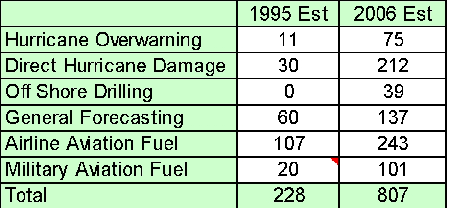
Kenneth Miller presented “Societal Benefits of Winds Mission.” A space mission meeting the Global Tropospheric Winds Sounder requirements will support a wide range of civilian, military, and scientific benefits to society. Estimates of quantifiable economic benefits in several areas totaled over $800 M per year. Benefits estimates are much greater than those made in 1995 because of increased fuel costs, coastal populations, property values, GDP, and inflation. Benefits accrue both from direct measurement of winds over the globe and from weather forecast improvements resulting from assimilation of real time direct wind observations. Current estimates and 1995 estimates (J. J. Cordes) are shown in the Table 2 for six areas. It was suggested that we discuss this topic with FAA, other agencies, and airlines, and present briefing to Pereira, Fulton and Adang at NOAA for follow-up.
Table 2. Benefits estimates from 1995 and 200 for six areas in $M per year.
Christopher Grund presented “An Alternative Direct Detection Approach to Doppler Winds that is Independent of Aerosol Mixing Ratio and Transmitter Frequency Jitter.” Chris discussed Optical Autocovariance Wind Lidar (OAWL) theory and its advantages. He discussed laser and receiver simplifications and advantages. OAWL has potential to combine or augment important aspects of both coherent and direct detection methods in transmitter, receiver, phenomenology, synergies and compatibilities. OAWL can measure both aerosol and molecular returns, cover the full altitude profile, and offer compatibility with High Spectral Resolution Lidar (HSRL), calibrated aerosols/clouds, Differential Absorption Lidar (DIAL, chemical species), and Raman (chemical species, temperature, pressure). A demonstration system architecture, brassboard system, proof of concept test range, early testing results, and first wind retrievals from December 2006 were discussed. Preliminary OAWL space lidar winds performance models were presented. Future work addresses improvements, ruggedization, validation, laser scaling issues, and performance modeling.
Brian Johnson presented “The Passive A-Band Wind Sounder (PAWS) for Measurement of Tropospheric Winds,” coauthored with S. Roark, P. Huang, G. Miecznik, R. Schwiesow, and P. Slaymaker. PAWS is a passive optical technique for measuring winds in the troposphere and lower stratosphere (0 to 20 km). It uses a Doppler Michelson Interferometer (DMI) concept based on the Wind Imaging Interferometer (WINDII) approach. Extending the DMI for tropospheric wind measurement is challenging because of large background flux, pressure dependence of line shape and position, and limited sensitivity in lower altitudes. PAWS measurement objectives include mid and upper tropospheric chemical transport studies, upper troposphere/ lower stratosphere exchange studies, and augmenting current wind measurements. Advantages of a passive optical technique were discussed. Space heritage includes Upper Atmosphere Research Satellite (UARS), WINDII, and High Resolution Doppler Imager (HRDI), whose specifications were described in a table. Measurement goals included 800 km orbit, 0-20 km sounding, 2 km vertical resolution, 250 km horizontal resolution, and +/-5 m/s wind speed uncertainty. The measurement approach included measurement of the Doppler shift of the O2 absorption line and biperspective observations. Oxygen A-Band spectrum, limb scattering geometry, vertical weighting functions, and interferometer were discussed. A demonstration instrument concept is being developed, with the interferometer being developed under a NASA Instrument Incubator Program. The breadboard is scheduled for atmospheric test in May 2007 and engineering model demonstration in November 2008. An airborne demonstration is planned in late 2008 or early 2009.
Discussion of the Implications of the NRC Decadal Survey: The Path Forward - All
There was a general discussion of the survey and findings of the NRC Decadal Survey Earth Science and Applications from Space: National Imperatives for the Next Decade and Beyond (see Reference below). The survey was conducted by the National Research Council Committee on Earth Science and Applications from Space. It developed a community assessment and strategy for the future. The findings related to global winds were discussed in depth. The survey rated global winds a high-priority mission. (Reference: Earth Science and Applications from Space: National Imperatives for the Next Decade and Beyond http://books.nap.edu/catalog/11820.html).
The community acknowledged the need for direct global measurement of wind profiles and the promise of substantial societal benefits. Ramesh Kakar’s Weather Focus Group gave highest priority to a global winds mission. Although technology readiness has been a concern in the past, the 2006 NASA conceptual designs, ESA Aeolus progress, and recent technology advances go a long way toward alleviating this concern for a demo mission. NASA will formally respond to the Decadal Survey report.
Ramesh Kakar (NASA HQ) indicated the need for a clear statement of partnership interest from the NOAA to support a budget request. Plans were discussed to brief senior NOAA leadership on the lidar winds status.
Plans were discussed to discussed to brief DoD. Major Dan Pawlak will follow up with the appropriate Air Force personnel. To gain DoD Space Test Program (STP) support will require both DoD commitment and NASA commitment to develop the instrument. There was discussion of NOAA’s consideration of new instruments and the need for discriminators to set priorities. OSSEs, cost benefit analyses, life-saving benefits, technology readiness, and unaccommodated EDR status were discussed as important discriminators that should be applied to all candidate instruments. It can be easier for NOAA to choose a new instrument that NASA has already demonstrated than an instrument in an earlier stage of development.
Plans for airborne DWL demonstrations were discussed, including TWILITE deployment in Winter 2008, and flight of a 2 micron system. Hardesty, Emmitt, Gentry and Kavaya will follow up on airborne demonstration planning.
Significant investments in the TODWL program by the US Navy and the NPOESS IPO were discussed.
Merits of a joint DWL and scatterometer mission were discussed.
Subcommittee Discussions
Meetings were held to review and formulate action items.
A government-only meeting was held with the Mission Definition Team (MDT), other government representatives, and Lockheed Martin representatives. The Lockheed Martin team provided a proprietary presentation on their Multiple Instrument Distributed Aperture Sensor (MIDAS) concept and responses to questions submitted earlier by the MDT.
Martin Endemann provided updates on the Aeolus program and opportunities for participation. The launch has been moved to mid 2009. An Announcement of Opportunity (AO) will be released in September 2007 for all calibration and validation activities during the three month Aeolus validation phase. This phase will conduct ground tests and assure that the DWL is working. If stratospheric wind measurement is determined to be important, Aeolus will measure winds at higher altitudes.
Presentation of Short Subjects
There were no short presentations.
Subcommittee Reports and Recommendations
There were no subcommittee reports.
Review of Action Items
Wayman Baker reviewed an extensive action item list. Action items were discussed and finalized. See the Action Items tab on LWG website for the complete list.
There was discussion of:
Next Meetings
The Summer 2007 meeting will be held in Snowmass, Colorado, July 17-20. The CLRC meeting will also be held in Snowmass the preceding week.
The Winter 2008 meeting will be in Monterey, California on dates to be determined at the Summer meeting.
The meeting was adjourned.
These minutes were prepared by Kenneth Miller.
| A2D | ALADIN Airborne Demonstrator |
| ADLAATS | Airborne Doppler Lidar Analyses and Adaptive Targeting System |
| ADM | ESA’s Atmospheric Dynamics Mission |
| AIRS | Atmospheric Infrared Sounder |
| ALADIN | Atmospheric Laser Doppler Instrument |
| AMSR-E | Advanced Microwave Scanning Radiometer-EOS |
| AMSU | Advanced Microwave Sounding Unit |
| ARO | Army Research Office |
| ASCAT | Advanced Scatterometer on MetOp |
| ATReC | Atlantic THORPEX Regional Campaign |
| AVHRR | Advanced Very High Resolution Radiometer |
| BAMS | Bulletin of the American Meteorological Society |
| CALIPSO | Cloud-Aerosol Lidar and Infrared Pathfinder Satellite Observation satellite |
| CAMEX | Convection and Moisture Experiment |
| CCD | Charge Coupled Device |
| CIRPAS | Center for Inter-Disciplinary Remotely Piloted Aircraft Studies |
| CLIO | Circle to Line Optic |
| Cv2 | Velocity Variance Constant |
| DAWN | Doppler Aerosol Wind Lidar |
| DIAL | Differential Absorption Lidar |
| DMI | Doppler Michelson Interferometer |
| DOD | Department of Defense |
| DLR | German Aerospace Centre |
| DLSM | Doppler Lidar Simulation Model |
| DMSP | Defense Meteorological Satellite Program |
| DWL | Doppler Wind Lidar |
| ECMWF | European Centre for Medium-range Weather Forecasts |
| EnKF | Ensemble Kalman Filtering |
| EOS | Earth Observing System |
| ESA | European Space Agency |
| ESRL | NOAA Earth System Research Laboratory |
| ESSP | Earth System Science Pathfinder (ESSP) program |
| ESTEC | European Space Research and Technology Center |
| ESTO | Earth-Sun System Technology Office |
| ETKF | Ensemble Transform Kalman Filter |
| FEA | Finite Element Analysis |
| fvGCM | finite volume General Circulation Model |
| GCM | General Circulation Model |
| GEO | Geosynchronous Earth Orbit |
| GEOSS | Global Earth Observation System of Systems |
| GFS | Global Forecast System |
| GLAS | Geoscience Laser Altimeter System |
| GLOBE | Global Backscatter Experiment |
| GLOW | Goddard Lidar Observatory for Winds |
| GOES | Geostationary Operational Environmental Satellite |
| GPS | Global Positioning System |
| GSFC | Goddard Space Flight Center |
| GTWS | Global Tropospheric Wind Sounder |
| GWHI | GroundWinds Hawaii |
| GWNH | GroundWinds New Hampshire |
| GWOLF | Ground-based Wind Observing Lidar Facility |
| GWOS | Global Wind Observing Sounder |
| HIRS | High Resolution Infrared Sounder |
| HLOS | Horizontal Line of Sight |
| HOE | Holographic Optical Element |
| HQ | Headquarters |
| HRDL | High Resolution Doppler Lidar |
| HRDI | High Resolution Doppler Imager |
| HSRL | High Spectral Resolution Lidar |
| ICESat | Ice, Cloud, and land Elevation Satellite |
| IIP | Instrument Incubator Program |
| I-LIMMS | In-flight Lidar Integrated Mission Management System |
| IMDC | GSFC Integrated Mission Design Center |
| INS | Inertial Navigation System |
| IORD | Integrated Operational Requirements Document |
| IPO | Integrated Program Office that manages NPOESS |
| ISAL | GSFC Instrument Synthesis and Analysis Lab |
| ISS | International Space Station |
| JCIDS | Joint Capabilities Integration and Development System |
| JCSDA | Joint Center for Satellite Data Assimilation |
| KNMI | Royal Netherlands Meteorological Institute |
| LaRC | Langley Research Center |
| LAWS | Laser Atmospheric Wind Sounder |
| LEO | Low Earth Orbit |
| LETKF | Local Ensemble Transform Kalman Filter |
| LRRP | Laser Risk Reduction Program |
| LWG | Working Group on Space-Based Lidar Winds, or Lidar Working Group |
| MACAWS | Multi-Center Airborne Coherent Atmospheric Wind Sensor |
| MDT | Mission Definition Team |
| METOC | Meteorological and Oceanographic |
| METOP | ESA Meteorological Operational Satellite |
| MODIS | Moderate-resolution Imaging Spectroradiometer |
| MOPA | Master Oscillator Power Amplifier Lidar |
| MSFC | Marshall Space Flight Center |
| NAS | National Academy of Sciences |
| NASA | National Aeronautics and Space Administration |
| NCEP | National Centers for Environmental Prediction |
| NEAQS | New England Air Quality Study |
| NESDIS | National Environmental Satellite, Data, and Information Service |
| NIR | Near infrared region of the electromagnetic spectrum |
| NPOESS | National Polar-orbiting Observing Environmental Satellite System |
| NPP | NPOESS Preparatory Project |
| NPS | Naval Postgraduate School |
| NSF | National Science Foundation |
| NWP | Numerical Weather Prediction |
| OES | Office of Earth Sciences |
| OLE | Organized Large Eddy |
| OLR | Outgoing longwave radiation |
| OMI | Ozone Monitoring Instrument |
| OPC | Ocean Prediction Center |
| OSSE | Observing System Simulation Experiment |
| PARC | Pacific Asia Regional Campaign (THORPEX) |
| P3I | Pre-Planned Product Improvement program (NPOESS) |
| PBL | Planetary Boundary Layer |
| PIEW | Prediction Improvement for Extreme Weather |
| PMT | Photomultiplier Tube |
| Prf | Pulse Repetition Frequency |
| RICO | Rain In Cumulus Over Oceans |
| SAIC | Science Applications International Corporation |
| SBIR | Small Business Innovation Research |
| SNR | Signal to Noise Ratio |
| SOSE | Sensitivity Observing System Experiment |
| SPORT | NASA Short-term Prediction Research and Transition Center |
| SSMI | Special Sensor Microwave Imager |
| STC | Science and Technology Corporation |
| STP | Space Test Program |
| SW | Solar shortwave radiation |
| SWA | Simpson Weather Associates |
| TexAQS | Texas Air Quality Study |
| THORPEX | The Hemispheric Observing system Research and Predictability Experiment |
| TKE | Turbulent Kinetic Energy |
| TODWL | Twin Otter DWL |
| TOVS | TIROS Operational Vertical Sounder |
| TRL | Technology Readiness Level |
| TTL | Tropical Tropopause Layer |
| TWiLiTE | Tropospheric Wind Lidar Technology Experiment |
| UAH | University of Alabama in Huntsville |
| UARS | Upper Atmosphere Research Satellite |
| UAV | Unmanned Aerial Vehicles |
| UNH | University of New Hampshire |
| UV | Ultraviolet |
| UWPBL | University of Washington Planetary Boundary Layer model |
| VALIDAR | Validation Lidar Facility |
| VIIRS | Visible Infrared Imager / Radiometer Suite |
| WINDII | Wind Imaging Interferometer |
| WSR | Winter Storm Reconnaissance Program |
