Vijay K. Gupta

BE, Civil Engineering, 1967, University of Roorkee, India
MS, Civil Engineering, 1971, Colorado State University
PhD, Hydrology, 1973, University of Arizona
Professor of Civil and Environmental Engineering
E-mail: gupta@cires.colorado.edu
Office: Ekeley S232
Phone: 303-492-3696
Web: Gupta Research Group
(Dept. of Civil, Environmental, and Architectural Engineering)
Research Interests
Vijay has published a total of 65 papers in international journals devoted to, hydrology, soil science, geosciences, nonlinear geophysics, applied mathematics, applied probability, ecology, applied meteorology, and fractals. He published 12 invited book chapters, most of which were peer reviewed. In addition, he published 7 papers in connection with his professional service. These publications address an overarching intellectual challenge that arises in unifying biophysical processes with statistical variability across multiple scales of space and time. The challenge of scale has guided Vijay's research career in hydrologic sciences, and his contributions to hydrologic education and service to the hydrology profession that has flowed from it.
The depth and breadth required to meet the profound scientific challenge of unification in hydrology across scales led Vijay to develop a highly interdisciplinary research career involving collaborative work with colleagues from mathematics, statistics, physics, ecology, fluvial geomorphology, environmental fluid mechanics, atmospheric sciences, and hydrologic engineering.
Vijay's publications are grouped into two parts: Contributions to Multi-scale Hydrologic Processes are highlighted in Part-A, which formed the foundations for Multi-scale Hydrologic Phenomena given in Part-B. Hydrologic phenomena consist of problems requiring a grand synthesis of coupled processes, geometry and statistics across multiple scales of space and time. Vijay's contributions to multi-scale hydrologic phenomena have been made mostly within the last decade.
Current Research: Generalizing a Scaling Flood Theory to Medium-Sized River Networks
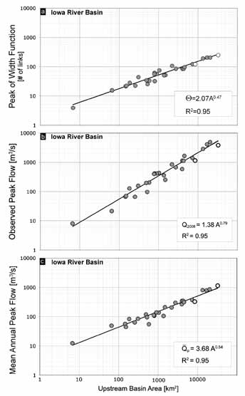
a) The scaling plot for the peak of the width function at 29 sites embedded in the Iowa River basin above Wapello, IA. The observed power law is a property of the river network structure. b) Observed peak flow values during the June 2008 event at the same sites, and c) Mean annual maximum streamflow estimated at the same locations. The existence of power-law relations in these datasets form the basis for diagnostics of the Geophysical Theory of Floods. Locations where gauging records are affected by upstream regulation are shown as empty circles.
The U.S. Geological Survey recently published a report on “Flooding in the United States Midwest, 2008.” It statesthat “the June floods were by far the most severe and widespread with substantial (andin places record) flooding and damage occurring in Illinois, Indiana,Iowa, Kansas, Michigan,Minnesota, Missouri, Nebraska, Oklahoma, SouthDakota, and Wisconsin.” The report, following the conventional hydrologic wisdom, says “record precipitation amounts, coupled with already saturated soils, resulted in flooding along many rivers in the United States Midwest.”
Gupta and his colleagues have uncovered that “selfsimilarity” in the spatial branching pattern of rivernetworks provides a key physical basis to understand the underlying spatial pattern of floods. Self-similarity meansthat that each part of a network is a tiny version of thewhole (panel a). Gupta and his colleagues analyzed the Geological Survey’s streamflow data from the Iowa floods of June 2008 at multiple locations in the Iowa River Basin.They observed the presence of a power law, or a scaling, relation (panel b). This observation supports the central hypothesis of a nonlinear geophysical flood theory—thatmulti-scale solutions of mass and momentum conservation equations on random self-similar channel networksproduce spatial scaling (power laws) in mean peak flows as drainage area increases to infinity. In this sense, scaling is an emergent property of the system that is not directly built into the conservation equations. The hypothesis supported by observations shown in the figure suggests that a key physical reason for flooding lies in the spatial organization of runoff due to river network pattern in a river basin. Preliminary simulation work of Iowa colleagues for the June 2008 flood event has documented that soils need not be saturated for major floods to occur.
The role of channel network in major flooding adds a fundamental new dimension in understanding and predicting floods. As mentioned in the 2009 CIRES Annual Report, practical applications of this theory will range from development of new methods to greatly improve real-time flood forecasting to estimation of annual flood frequencies for the management of flood plains in a changing climate.