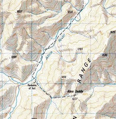
Map of upper Alma River and Alma saddle. Attempted to drive up the road 5/31/01--lost it 2.5 km south of Tarndale Road; little evidence of use, and muddiness of area made driving farther seem unwise. Assuming not accessible unless we get clearer information. DOC reported the road is reasonable, but a long drive from anywhere. Anna of Moleworth Stn says it is more like cattle tracks than a road (4WD certainly) and that they put young cattle up here that are easily distracted and inadvertantly led off from where they shoud be. Presumably would use north-south leg up the river and east-west through the saddle (recreation maps show a track continuing east from the saddle).
Site owners: Molesworth Station. Possible DOC involvement here, though informally they suggested it probably not a problem.