Left-Lateral Movement Along the Wichita Megashear
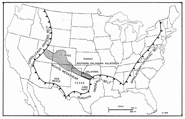
Budnik (1986) proposes that the deformation that produced the Ancestral Rockies took place along a pre-existing zone of weakness called the Wichita megashear (Figure 1). This NW-SE-trending feature has a fault history that stretches back into the Proterozoic, but the sense of displacement during the late Paleozoic is not fully understood. Many workers follow the more intuitive argument that the region south of the Wichita megashear was displaced towards the west to create the Ancestral Rockies, resulting in a right-lateral sense of shear (Kluth and Coney, 1981). Budnik (1986) presents structural analysis in the field that reveals left-lateral offset along the megashear during the Pennsylvanian.
Figure 1 - Orientation of the Wichita megashear in relation to the Appalachian, Ouachita, and Cordilleran orogenic belts. From Budnik (1986).
The Wichita megashear can be divided into three parts: an eastern segment stretching from Oklahoma to the Texas Panhandle, a middle segment in northeastern New Mexico and southern Colorado, and a western segment in southwestern Colorado and eastern Utah. The eastern segment contains structures that best preserve movement during the Pennsylvanian because the region largely escaped the extensive Laramide overprinting that occurred further west. The Southern Oklahoma Aulacogen (Figure 1) is a widely recognized structure believed to have formed during a rifting event 525-550 Ma that created a trough filled with over 6 km of bimodal volcanics and intrustives. Subsidence and cooling following the rifting event formed the Anadarko basin, which subsequently filled with Paleozoic sediments. Pennsylvanian-Permian uplift of the Amarillo-Wichita blocks and accelerated subsidence of the Anadarko-Ardmore basins deposited 4 km more of coarse sediment into the basins. The Wichita uplift was thrust northward along 30-40 degree south-dipping faults and carried over the deepest part of the Anadarko basin, with over 11 km of structural relief. The Amarillo uplift, bound by vertical to high-angle reverse faults, records 6 km of relief across its northeastern front and 3 km across its southwestern boundary. Other smaller basement uplifts in the eastern section of the megashear display an overall northwestern trend with left-stepping en-echelon basement highs. Thrust sheets of the Ouachita Mountains overlie the southeastern end of the megashear.
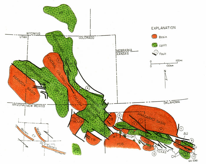
Figure 2 - Structural trends of the Wichita megashear, with inset showing the three segments of the megashear and inferred sense of shear during the Pennsylvanian. Minor structures are: AB - Ardmore Basin, AU - Arbuckle Uplift, BD - Bravo Dome, CA - Cimarron Arch, CH - Criner Hills, DB - Dalhart Basin, HDB - Hardeman Basin, HSB - Hollis Basin, LB - LeFors Basin, MB - Marietta Basin, MU - Muenster Uplift, OHT - Oldham-Harmon structural trend, PD - Pedernal Uplift, PDB - Palo Duro Basin, PF - Pathfinder Uplift, TB - Tucumcari Basin, TU - Tishomingo Uplift, WT - Whittenburg Trough. Faults are numbered: 1 - Uncompahgre frontal fault, 2 - Gore fault, 3 - Ilse fault, 4 - Apishapa fault, 5 - Potter County fault, 6 - Wheeler County fault, 7 - Lips fault, 8 - Mountain View fault, 9 - Reagan fault, 10 - Washita Valley fault, 11 - central Oklahoma fault, 12 - Burch fault. From Budnik (1986).
A predominant left-lateral offset during the Pennsylvanian is recorded in en-echelon northwest-trending folds, synthetic and antithetic minor faults and fractures, subhorizontal slickensides along the Washita Valley fault and Reagan fault, displaced pre-Devonian subcrop, offset folds, positive flower structures along the Washita Valley fault, and pull-apart basins within the Amarillo uplift. The amount of offset has been estimated at 120-150 km based upon displaced Devonian subcrop and isopach trends in the Amarillo-Wichita uplift and Anadarko basin.
The middle segment of the megashear includes the Apishapa-Sierra Grande Uplift, which is bound by northwest-trending Pennsylvanian faults. Desmoinesian isopach patterns in the southeastern Central Colorado Trough suggest small fault-bounded troughs with a northwest orientation. The Gore-Ilse fault system contains intrusives and cross-cutting relationships that reflect recurrent activity during the Proterozoic and Phanerozoic eras. Coarsening of early Paleozoic sediments against the Gore-Ilse fault system provides evidence of repeated activation of the Frontrange uplift throughout the Paleozoic.
The western segment may contain faults that developed as early as 1700 Ma, based upon cross-cutting relationships and intrusives in the San Juan Mountains of southwestern Colorado. Cambrian dikes suggest that this portion of the megashear was reactivated during the opening of the Southern Oklahoma Aulacogen, and basin stratigraphy reveals repeated reactivations throughout the Paleozoic. Deformation during the Pennsylvanian created 2 km of structural relief between the Uncompahgre uplift and the Paradox basin.
Budnik (1986) argues that the Kluth and Coney (1981) model that connects Ancestral Rocky orogenesis to the Ouachita-Marathon orogeny requires right-lateral movement along the Wichita megashear, instead of the left-lateral movement that structural field analysis supports. Budnik presents an alternative model in which continental collision along the eastern margin of North America is responsible for the stresses that produced the Ancestral Rockies. If the Appalachians were the main suturing zone between Gondwana (S. America and Africa) and Laurussia (N. America and Europe) instead of the Ouachitas, the collision would transmit east-west stresses across the megashear that would result in left-lateral offset. The Alleghenian orogeny produced hundreds of kilometers of shortening in the Appalachians, while the Ouachita orogeny only records 50-100 km in Arkansas and Texas. This suggests a change from easterly movement of Africa relative to North America to more northerly movement during the late Pennsylvanian-early Permian. The change to a more northern motion vector would have brought South America into contact with North America and initiated thrusting in the Marathon and Arbuckle Mountains.