Transtension in the West
The geometry of structures and sedimentary patterns in several Pennsylvanian basins of the Ancestral Rocky Mountain region suggest the presence of tension and shear stresses acting upon the western half of North America during the late Paleozoic. Studies of the Paradox basin in southwestern Colorado (Stevenson and Baars, 1986) and the Uinta-Piceance basin region in northwestern Colorado and northeastern Utah (Johnson et al., 1991) add new interpretations to the possible origins of the Ancestral Rockies.
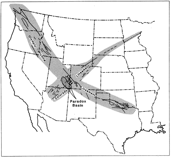
A complete understanding of the history of the Paradox basin includes a mention of pre-existing weaknesses in the North American craton. Fractures along two major lineaments, the Olympic-Wichita lineament trending northwest and the Colorado lineament trending northeast, are dated at 1675-1460 Ma and 1700 Ma, respectively (Figure 1). The close correlation of ages has led to the interpretation that the lineaments were a conjugate pair formed by north-south compression of the craton. The northwesterly fractures have primarily dextral strike-slip displacement, while the northeasterly fractures are mostly sinistral. The Paradox basin is believed to have formed by east-west crustal extension at the intersection of the Colorado and Olympic-Wichita lineaments (Stevenson and Baars, 1986).
Figure 1 - Proterozoic basement lineaments of the western United States, with the Paradox basin at their intersection. From Stevenson and Baars (1986).
Fault systems along the lineaments show evidence of repeated reactivation throughout the Phanerozoic, but it was during Pennsylvanian time when activity intensified, forming the Ancestral Rockies and the Paradox basin. Stevenson and Baars (1986) summarize the development of deformation as follows: During Atokan time, divergent dextral motion along the Uncompahgre-San Luis fault system created a releasing bend at the intersection with the Coconino-House Creek lineament (Figure 2). The Four Corners lineament absorbed much of this releasing strain through left-lateral motion, and by early Desmoinesian time, the basin's pull-apart geometry was well-established. Basement extension continued into the Desmoinesian age, when additional sub-basins developed. Chronology of basin development is well-documented on the basis of evaporite cycles and arkosic clastic sediments that were bound by uplifts and lineaments at the time of deposition. The arkosic sediments were shed off of the rising Uncompahgre and San Luis uplifts, while evaporites accumulated due to the restricted marine environment in the pull-apart basin. Collapse of the basin slowed during late Desmoinesian time and by the late Pennsylvanian-early Permian, normal marine conditions prevailed, indicating a cessation of deformation. Structures and stratigraphy of the Paradox basin therefore indicate an overall east-west extensional stress regime of western North America during the late Paleozoic.
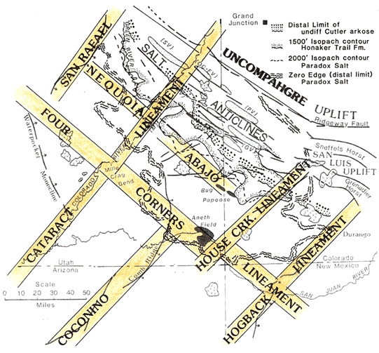
Figure 2 - The Four Corners region during the Pennsylvanian period, illustrating the lineaments that determined Paradox basin pull-apart geometry and the distribution of sediments within the basin. From Stevenson and Baars (1986).
Smith and Miller (1990) provide geologic field evidence of east-west extension during the late Paleozoic. In the Toiyabe Range of central Nevada, Cambrian to early Mississippian strata are cut and tilted by normal faults and overlain by Pennsylvanian-Permian sediments. The normal faults strike east-west and dip northward, and are accompanied by subsidence and mafic volcanism. Smith and Miller conclude that the Ancestral Rockies formed from a combination of extensional and compressional forces coming from the west and southeast, respectively.
Johnson et al. (1991) arrive at a similar conclusion through their study of the Uinta-Piceance basin region. This region includes the Eagle basin, the northern Paradox basin, the southern Wyoming shelf, and the southeastern part of the Oquirrh basin (Figure 3). In all four of these basins, subsidence reached its highest rates in the mid-Pennsylvanian period, which along with the geometry of subsidence, suggests tectonic influences on Ancestral Rocky deformation from both a transform boundary to the west and a subduction zone to the southeast (Johnson et al., 1991). The mixture of compressional and extensional features in the region best correlates with strike-slip-driven deformation. The timing of basin subsidence suggests a western driving force for the deformation of the Oquirrh basin and Wyoming shelf, while the transpressional style of the Paradox basin and Eagle basin are more likely to be associated with a convergent margin to the southeast.
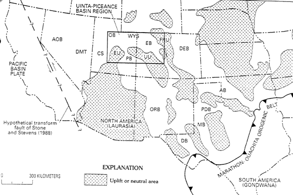
Figure 3 - Paleogeography of the Uinta-Piceance basin region in the context of greater late Paleozoic North America and inferred activity along continental margins to the west and southeast. AB - Anadarko basin; AOB - Antler overlap basins; CS - Callville shelf; DB - Delaware basin; DEB - Denver basin; DMT - Dry Mountain trough; EB - Eagle basin; EU - Emery uplift; FRU - Front Range uplift; MB - Midland basin; OB - Oquirrh basin; ORB - Orogrande basin; PB - Paradox basin; PDB - Palo Duro basin; UU - Uncompahgre uplift; WYS - Wyoming shelf. From Johnson et al. (1991).
Stone and Stevens (1988) present stratigraphic evidence of southeast-trending continental truncation of the western margin of North America during Pennsylvanian to Permian time. The southwest-trending late Mississippian carbonate shelf is overlain by Morrowan to Wolfcampian facies boundaries trending to the southeast (Figure 4). The 0.706 Sr isopleth, which defines the edge of the late Paleozoic continent, also bends towards the southeast. Continental truncation was accompanied by thrust faulting and basin subsidence in what is now south-central California during middle to late Wolfcampian time, indicating strike-slip motion along the continent's western margin. Stone and Steven's interpretation places this truncation event earlier than a previously hypothesized late Permian to Triassic event.
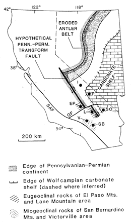
Figure 4 - Paleogeographic map of the Pennsylvanian-Permian western continental margin. EP - El Paso Mountains; GF - Garlock Fault; I - Inyo Mountains; L - Lane Mountain; P - Panamint Range; SAF - San Andreas Fault; SB - San Bernadino Mountains; SO - Soda Mountains; V - Victorville. From Stone and Stevens (1988).