Palinspastic restoration of the thrust belt places classically defined North American rocks west of the edge of North America as defined by 0.706 87Sr/86Sr line
Is the 0.706 line an appropriate marker for the continental edge?
Is the 0.706 line correctly or robustly defined?
Rachel Havranek and Jim Mize
The initial 87Sr/86Sr ratio of igneous rocks in California and the Great Basin vary systematically with geographic location (Leeman 1970; Kistler and Peterman 1973). This systematic variation can be contoured, producing an increasing-eastward set of contour lines spanning the height of North America. Kistler and Peterman (1973) noted that the 0.706 contour line near the California border is coincident with the trend and near the boundary between Paleozoic miogeosynclinal and eugeosynclinal rocks. They also noted that the 0.706 contour is near the southern depositional limit of early Triassic sedimentary rocks in western Nevada and is approximately coincident with the southern limit of the Golconda allochthon.
Kistler and Peterman (1973) went on to state that both the 0.704 and the 0.706 contours are boundaries of major crustal contrasts that have been perpetuated since at least the late Proterozoic. They assert that the 0.706 line represents the boundary between shelf deposition (to the south and east) and eugeosynclinal deposition (to the north and west). This facies change represents the edge of North America.
The facies change’s close proximity to the 0.706 Sr isopleth has led to the belief that the 0.706 isopleth represents the boundary of North America. This notion has been strongly perpetuated in isotopic literature in Western North America (e.g. Farmer and DePaulo 1983, Elison et al., 1990, Wright and Wooden 1991, Decelles, 2004, Gehrels, 2000, Whitmeyer and Karlstrom, 2007, Jones et al., 2015).
In Hildebrand (2009) and Hildebrand (2013), the author proposes a novel mechanism by which Phanerozoic tectonic history of the Western U.S. may be reinterpreted. Hildebrand’s hypothesis is a means to reconcile a number of lines of reasoning that do not align with the eastward subduction of a slab prior to the Cordilleran orogeny. One particular line of reasoning that Hildebrand takes issue with is the use of the 87Sr/86Sr 0.706 isopleth as a marker of the edge of North America. Hildebrand argues that this mode of estimation fails because the restoration of Sevier and Basin and Range shortening places rocks classically thought to be North American outside of the shelf edge (Hildebrand, 2009, p. 6). Additionally, Hildebrand argues that an 87Sr/86Sr ratio above 0.706 is indicative only of overlying crust, and not of North American crust in particular and may instead be interpreted as crust below the Rubian terrane (Hildebrand, 2009, p.24). The purpose of this paper is to investigate Hildebrand’s proposition that the 0.706 isopleth is not a useful indicator of the North American margin. We will do this in two ways: the first is to investigate if the location 0.706 isopleth has been correctly defined based on existing data. The second is to discuss if the 0.706 isopleth is an appropriate means of estimating the margin of a continent.
|
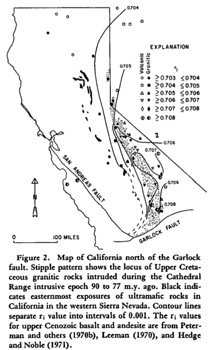
Figure 1. From Kistler and Peterman, 1973. It is important to note that the authors attribute the location of 2 measurements west of the San Andreas Fault as part of North America that was subsequently shifted by the fault. |
 |
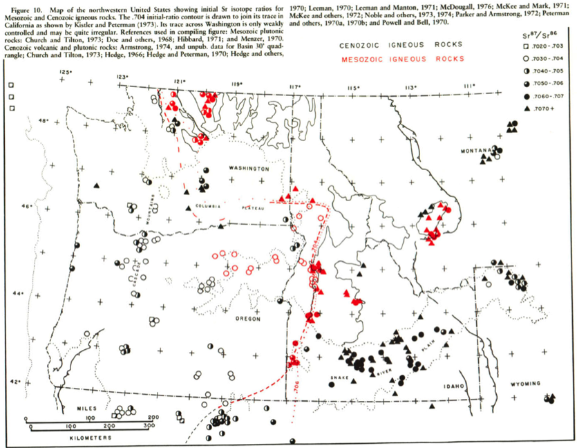
Figure 2. From Farmer and DePaolo, 1983. This figure shows the location of the 0.706 line through Nevada. |
| |
|
|
| Figure 3. From Armstrong et al., 1977. The authors identified the location of the 0.706 line through Idaho and Washington. |
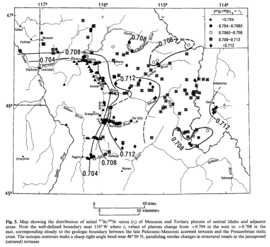 |
Figure 4. From Fleck and Criss, 1985. |
The 0.706 isopleth was defined by a number of authors starting in the early 70’s. In the Sierra Nevada the isopleth runs through the Sierra, wraps around and southward briefly to the California-Nevada Border (Figure 1) (Kistler and Peterman, 1973). In California, Kistler and Peterman call on complex geometries to explain >0.706 isopleths. These geometries do not reflect a smooth transition between compositions as may be expected, but nonetheless the authors were able to draw discrete boundaries between isotopic compositions. In Nevada, the 0.706 line is approximately 100 km west of the edge of Precambrian basement (Figure 2) (Farmer and DePaolo., 1983, Leeman et al., 1992). The proposed isopleth runs nearly directly north up to Idaho nearly along the Idaho suture zone, and then turns westward into Washington (Figure 3) (Armstrong et al., 1977, Evans et al., 2002). In Idaho, there are klippes of material with an 87Sr/86Sr ratio >0.706, but that are lower than their surrounding ratios, which is consistent with the thrusting of allocthonous material onto the continent (Figure 4) (Fleck and Criss, 1985). In northern Washington, the line is not robustly defined because of tight geographic clustering of a variety of 87Sr/86Sr values. This convolution is continued into Canada where the boundary between rocks >0.706 represents more of a transition rather than a hard line (e.g. Ghosh, 1995). Overall, the 0.706 87Sr/86Sr line in robustly defined as a hard boundary through California, Nevada, Idaho and southern Washington. However, near the Canadian border, the line begins to fall apart as isotopic ratios occur as part of a transition zone rather than a border.
The 0.706 87Sr/86Sr line is not an appropriate marker for the edge of North America. Hildebrand (2009) correctly raises the point that restoration of the shortening experienced by North America puts many North American rocks beyond the shelf edge, and places Nevada beyond the hypothesized edge of North America.
Further evidence for the unreliability of the 0.706 87Sr/86Sr isopleth as a proxy for the edge of North America can be found in Evans and others (2002). They used three different lines of evidence to find the location of the suture under southeastern Oregon between North America and exotic terranes accreted onto North America.
The first line of evidence is found in xenoliths in Mesozoic and Tertiary volcanic and plutonic rocks. These xenoliths span a huge range of sizes (millimeters to hundreds of meters) and compositions (rhyolite to basalt). Overall, the xenolith data suggest the location of the cratonic margin is between the northern Pueblo Mountains and Westfall Butte.
The second and third lines of evidence are geophysical and geochemical data, and they support and refine the results derived from the xenoliths. The gravity, aeromagnetic, airborne radiometric, and assorted geochemical data together suggest that there are significant differences in crustal and subcrustal lithologies.
The conclusion reached by Evans and others (2002) is that the surface trace of the suture between North America and the terranes accreted onto the western margin of North America is over 100 km west of where the 87Sr/86Sr 0.706 contour lies. This huge disparity in locations makes the 87Sr/86Sr 0.706 contour unsuitable as a proxy for the edge of North America.
Though previous workers have correctly identified the location of the 0.706 isopleth, it is ultimately not a useful measure of the margin of North America. We agree with Hildebrand that the 0.706 does not accurately reflect the margin. It has been perpetuated in the literature unnecessarily, and its use should henceforth be terminated.
References
Armstrong, R.L., Taubeneck, W.H. and Hales, P.O., 1977. Rb-Sr and K-Ar geochronometry of Mesozoic granitic rocks and their Sr isotopic composition, Oregon, Washington, and Idaho. Geological Society of America Bulletin, 88(3), pp.397-411.
DeCelles, P.G., 2004. Late Jurassic to Eocene evolution of the Cordilleran thrust belt and foreland basin system, western USA. American Journal of Science, 304(2), pp.105-168.
Elison, M.W., Speed, R.C. and Kistler, R.W., 1990. Geologic and isotopic constraints on the crustal structure of the northern Great Basin. Geological Society of America Bulletin, 102(8), pp.1077-1092.
Evans, J.G., Griscom, A., Halvorson, P.F. and Cummings, M.L., 2002. Tracking the western margin of the North American Craton beneath southeastern Oregon: A multidisciplinary approach. Bonnichsen, B., White, CM, and McCurry. M., eds., Tectonic and Magmatic Evolution of the Snake River Plain Volcanic Province: Idaho Geological Survey Bulletin, 30, pp.35-57.
Farmer, G.L. and DePaolo, D.J., 1983. Origin of Mesozoic and Tertiary granite in the western United States and implications for Pre‐Mesozoic crustal structure: 1. Nd and Sr isotopic studies in the geocline of the Northern Great Basin. Journal of Geophysical Research: Solid Earth, 88(B4), pp.3379-3401.
Gehrels, G.E., 2000. Introduction to detrital zircon studies of Paleozoic and Triassic strata in western Nevada and northern California. Special Paper of the Geological Society of America, 347, pp.1-17.
Ghosh, D.K., 1995. Nd-Sr isotopic constraints on the interactions of the Intermontane Superterrane with the western edge of North America in the southern Canadian Cordillera. Canadian Journal of Earth Sciences, 32(10), pp.1740-1758.
Jones, J.V., Daniel, C.G. and Doe, M.F., 2015. Tectonic and sedimentary linkages between the Belt-Purcell basin and southwestern Laurentia during the Mesoproterozoic, ca. 1.60–1.40 Ga. Lithosphere, 7(4), pp.465-472.
Kistler, R.W. and Peterman, Z.E., 1973. Variations in Sr, Rb, K, Na, and initial Sr87/Sr86 in Mesozoic granitic rocks and intruded wall rocks in central California. Geological Society of America Bulletin, 84(11), pp.3489-3512.
Leeman, W. and Manton, W., 1970, January. 87Sr/86Sr ratios of Snake River Plain basalts.
In Transactions – American Geophysical Union (Vol. 51, No. 4, p. 444).
Leeman, W.P., Oldow, J.S. and Hart, W.K., 1992. Lithosphere-scale thrusting in the western US Cordillera as constrained by Sr and Nd isotopic transitions in Neogene volcanic rocks. Geology, 20(1), pp.63-66.
Whitmeyer, S.J. and Karlstrom, K.E., 2007. Tectonic model for the Proterozoic growth of North America. Geosphere, 3(4), pp.220-259.
Wright, J.E. and Wooden, J.L., 1991. New Sr, Nd, and Pb isotopic data from plutons in the northern Great Basin: Implications for crustal structure and granite petrogenesis in the hinterland of the Sevier thrust belt. Geology, 19(5), pp.457-460.