Anne Fetrow
An alternative to the conventional interpretation of the development of the western Cordillera of the United States was proposed by Robert Hildebrand in 2009 and 2013. This new hypothesis is comprehensive, controversial, and attempts to reconcile flaws in the logic of the traditional Cordillera-building model (referred to here as the “back-arc” model). Hildebrand’s hypothesis relies on the westward subduction of the North American continent underneath a proposed ribbon continent called “Rubia” that existed to the west of North America. The suturing occurred in the Cretaceous and is best exposed in the Ruby Mountains in Nevada (Hildebrand 2013). This is in direct opposition of the “back-arc” model that employs only eastward subduction off the coast of the western United States. Hildebrand asserts that widespread asthenosphere-sourced magmatism in the western US during the late Cretaceous is the result of asthenosphere rising through a tear in the subducting North American slab beneath “Rubia”. This rise of hot asthenosphere caused widespread deformation of the western US, including the Laramide uplift. To assess the merit of this portion of Hildebrand’s hypothesis, it is first important to examine the observations and resulting interpretations of the timing, elevation estimations, and patterns of the Laramide uplift.
|
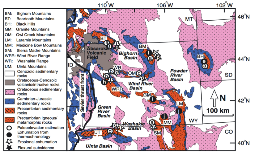
| Figure 1. Simplified geologic map of Wyoming, including most major Laramide uplift provinces (from Fan et al., 2014). Each lower-case letter references to another study and data therein which is explained in further detail in the Fan et al. (2014) figure caption. |
The Laramide Uplift is described as a time of extensive thick-skinned deformation that has classically attributed to the shallowing of the Farallon Plate under North America. The resulting ‘block uplift’ in Montana, Wyoming, and Colorado occur over a 1000 km from the proposed plate margin (Figure 1) (Decelles, 2004; Crowley et al., 2002). A variety of techniques such as oxygen stable isotopes (Fan and Carrapa., 2014; Mix et al., 2011; Fan, 2009), apatite fission track dating (Crowley et al., 2002; Omar et al., 1994), and U-Pb geochronology of detrital zircons (Rowley et al., 2016) have been used to examine the timing, elevation estimations, and regional patterns.
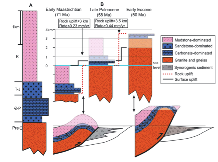 |
| Figure 2. Schematic diagram of surface uplift and exhumation during the two stage Laramide uplift (from Fan et al., 2014). Portions that are transparent represent erosion, which is equivalent to exhumation. |
 The timing of the uplift has been proposed by several workers to have happened in two stages: 1) a slower first stage that began in the early-Maastrichtian and tapered off in the mid-Paleocene and 2) a faster uplift stage that lasted from the late-Paleocene to the early-Eocene (Figure 2) (Fan and Carrapa., 2014; Chamberlain et al., 2012; Dickinson, 2004; Omar et al., 1994). To explore this pattern, Fan and Carrapa (2014) compare δ18O values from a wide of range of materials to a modeled relationship with elevation (Quade et al., 2007; Rowley, 2007). Initiated in the early-Masstrictian (~71 Ma), total rock uplift less than 2.4-4.8 km (~0.21–0.32 mm/yr) was estimated using a combination of regional stratigraphy thicknesses, paleoelevation estimates, and erosional exhumation data. The second stage is marked by its increased uplift rate and thought to have be approximately 3 km of uplift (~0.38-0.60 mm/yr) (Fan and Carrapa, 2014). Crowley et al. (2002) used apatite (U-Th)/He ages to estimate that exhumation happened around 65 ± 5 Ma for the Bighorn Mountains, complimenting work done by Omar et al. (1994) that reported uplift estimates from the Beartooth Mountains to be between 7-12 km during the early Paleocene. Additionally, paleotopographic relief estimates from oxygen isotope data is reported by Dettman and Lohmann (2000) to be between 2.5 and 3 km during the Paleocene into the early-Eocene, which is consistent with work by Decelles (2004).
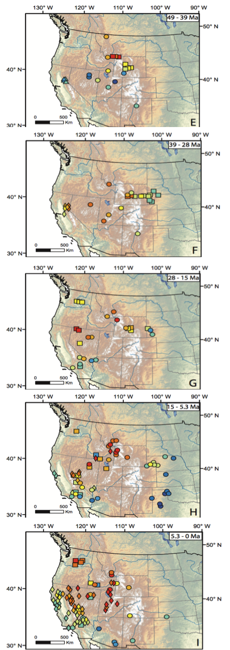
Combining findings for the timing of the Laramide uplift with the estimation for surface elevations has resulted in the proposition of a north to south propagation of uplift throughout the late-Cretaceous into the mid-Eocene (Chamberlain et al, 2012; Mix et al., 2011). Chamberlain et al. (2012) combine oxygen isotope records from a multitude of sources to better understand how climate and surface elevation interacted throughout the Cenozoic. They propose a southward “topographic wave” that swept down from southern Canada across the western US, which started ~50 Ma and reached southwestern Nevada by ~39 Ma. This systematic southward elevation increase is seen through the reorganization of drainage patterns and the depletion of oxygen isotope values (Figure 3) (Davis et al., 2009). This work sits upon the shoulders of Mix et al. (2011) that argued for a very similar north to south propagation of uplift, culminating in an assembly of an Eocene-Oligocene highlands that extended from southern British Columbia through the Rocky Mountains and into the Great Basin region that had elevations of 3-4 km. They interpret this topographic wave to be coincident with the north-to-south migration of magmatism and metamorphic core complex formation.
There have been several proposed mechanisms for this surface uplift and concurrent magmatism which include the removal of the eastward subducting Farallon slab (Sigloch et al., 2008), the thermal erosion of the lithosphere by hot upwelling asthenosphere (Saltus and Thompson, 1995), and a tear in the westward subduction of the North American plate under the ribbon continent “Rubia” (Hildebrand, 2013 and 2009). Further examination of the region needs to be done to present more robust arguments for any of these uplift mechanisms. But in general, one large question that needs to be explored is whether or not ~4 km of uplift could be explained solely but rising asthenosphere in this instance, such as Hildebrand proposes (2013, 2009), and what other mechanisms can be pointed to explain the Laramide uplift.
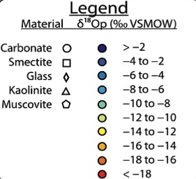 |
Figure 3. Calculated δ18O values from precipitation from 49 Ma to Present (modified from Chamberlain et al., 2012). Different symbol shapes refer to the variety of materials used and the color of symbols indicated δ18O values for each site. Figure illustrated the sweep of depleted δ18O values from north to south over time. |
References
Chamberlain, C. P., Mix, H. T., & Mulch, A. (2012). The Cenozoic climatic and topographic evolution of the western North American Cordillera. American Journal of Science. 212. 213-262.
Crowley, P. D., Reiners, P. W., Reuter, J. M., & Kaye, G. D. (2002). Laramide exhumation of the Bighorn Mountains, Wyoming: An apatite (U-Th)/He thermochronology study. Geology, 30(1), 27–30.
Davis, S. J., Mix, H. T., Wiegand, B. A., Carroll, A. R., & Chamberlain, C. P. (2009). Synorogenic evolution of large-scale drainage patterns: Isotope paleohydrology of sequential Laramide basins. American Journal of Science, 309(7), 549–602.
DeCelles, P. G. (2004). Late Jurassic to Eocene evolution of the Cordilleran thrust belt and foreland basin system, western U.S.A. American Journal of Science, 304(2), 105–168.
Dettman, D. L., & Lohmann, K. C. (2000). Oxygen isotope evidence for high-altitude snow in the Laramide Rocky Mountains of North America during the Late Cretaceous and Paleogene. Geology, 28(3), 243–246.
Dickinson, W. R. (2004). Evolution of the North American Cordillera. Annual Review of Earth and Planetary Sciences, 32(1), 13–45.
Fan, M., & Carrapa, B. (2014). Late Cretaceous–early Eocene Laramide uplift, exhumation, and basin subsidence in Wyoming: Crustal responses to flat slab subduction. Tectonics.
Fan, M. (2009). Geochemistry and basin analysis of Laramide Rocky Mountain basins (Doctoral Dissertation). Retrieved from The University of Arizona.
Mix, H. T., Mulch, A., Kent-Corson, M. L., & Chamberlain, C. P. (2011). Cenozoic migration of topography in the North American Cordillera. Geology.
Omar, G. I., Lutz, T. M., & Gieegengack, R. (1994). Apatite fission-track evidence for Laramide and post-Laramide uplift and anomalous thermal regime at the Beartooth overthrust, Montana-Wyoming. Geological Society of America Bulletin, 106(1), 74–85.
Quade, J., Garzione, C., & Eiler, J. (2007). Paleoelevation Reconstruction using Pedogenic Carbonates. Reviews in Mineralogy and Geochemistry, 66(1), 53–87.
Rowley, J., & Fan, M. (2016). Middle Cenozoic diachronous shift to eolian deposition in the central Rocky Mountains: Timing, provenance, and significance for paleoclimate, tectonics, and paleogeography. Geosphere. 12(6).
Sigloch, K., McQuarrie, N., & Nolet, G. (2008). Two-stage subduction history under North America inferred from multiple-frequency tomography. Nature Geosciences.