 |
 |
| Chase Home | People | Projects | Publications | Classes | Contact |
| RESEARCH GROUPS @ CIRES > |
Global Community Land Model (CLM 3.0) Land Surface ParametersAs part of our investigations into the role of the land surface in the climate system and the impacts that land cover change have on the climate system, we have developed global land data sets and land surface parameters for the Community Climate System Model that represent current day and potential vegetation land surface distributions. These new global land surface data sets and parameters are available for download at a range of resolutions and spatial extents through the CIRES Global Land Model Dataset Download Facility . Current Day MODIS Parameters: New current day CLM 3.0 land surface parameters have been developed from a range of MODIS land surface products at a grid cell resolution of 0.05 degrees. The new CLM 3.0 land surface parameters reproduce the physical properties described in the MODIS land surface data while maintaining the multiple Plant Functional Type (PFT) canopy and herbaceous layer representation used in CLM. The new parameters prescribe crop distributions directly from historical crop mapping allowing cropping to be described in CLM for any year from 1700 to current day. The new model parameters are calculated at 0.05 degrees resolution so they can be aggregated and used over a wider range of model grid resolutions globally. The land surface parameters are the new standard current day land surface provided by NCAR for use with CLM 3.5 and can be used for a wide range of applications from global to regional land surface modeling. The land surface parameters and the impact they have on global climate simulated in CCSM 3.0 are described in Lawrence and Chase, (2007) and in the CLM 3.5 supporting documentation Oleson et al., (2007). Potential Vegetation Parameters: New global potential vegetation land surface parameters for CLM have been developed in Lawrence and Chase, (2008) that are consistent with the potential vegetation biome mapping of Ramankutty and Foley, (1999). The new parameters have been developed for use in land cover change experiments with the same methods used in the MODIS current day land surface parameters to ensure consistency in plant functional types, vegetation cover and leaf area phenology. The potential vegetation parameters also can be used with historical cropping records to generate a continuous series of global land cover change parameters running from 1700 to current day as described in Feddema et al., (2007). These parameters are being used by a wide range of research groups for global land cover change studies. We are currently working with Johannes Feddema (University of Kansas) to develop a new range of historical and future land cover change scenarios for use in future International Panel on Climate Change modelling investigations. References: Feddema, J.J., P.J. Lawrence, J. Bauer, and T. Jackson, 2006: A global land cover dataset for use in transient climate simulations. (In Review) Journal of Applied Meteorology and Climate Lawrence, P.J., and T.N. Chase, Climate Impacts of Potential Vegetation versus Current Day MODIS Land Cover in the Community Climate System Model (CCSM), Journal of Geophysical Research, In Review, 2008 Lawrence, P. J. and T. N. Chase, 2007: Representing a new MODIS consistent land surface in the Community Land Model (CLM 3.0). J. Geophys. Res.-Biogeosci.: Vol. 112 Oleson, K.W., G.-Y. Niu, Z.L. Yang, D.M. Lawrence, P.E. Thornton, P.J. Lawrence, R. Stockli, R.E. Dickinson, G.B. Bonan, and S. Levis, 2007, Technical Description of the Community Land Model (CLM 3.5), NCAR, Boulder, Colorado. Ramankutty, N., and J. A. Foley, 1999, Estimating Historical Changes in Global Land Cover: Croplands from 1700 to 1992, Global Biogeochemical Cycles, 13 (4), 997-1027 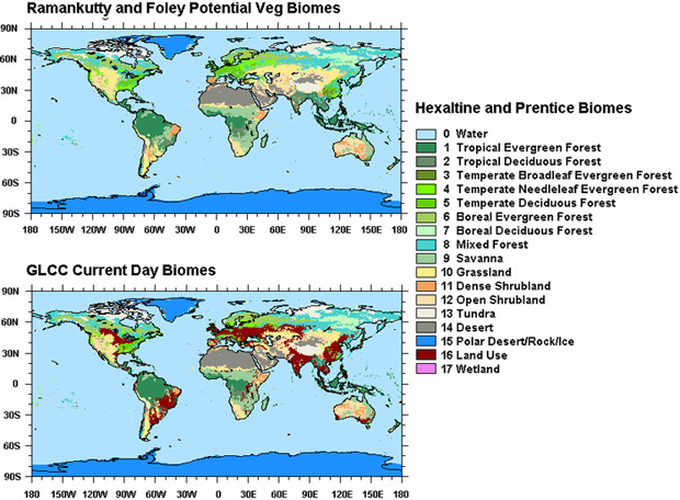
|