|
 |
| Steffen Home | People | Projects | Publications | Classes | Contact |
| RESEARCH GROUPS @ CIRES > |
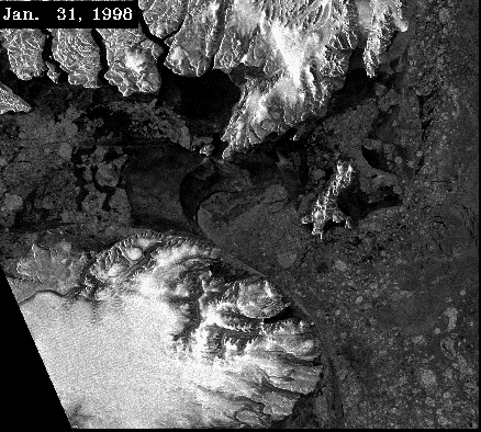
The Polynya in Lady Ann Strait, Jones Sound, NW Baffin Bay, Arctic Canada: A Time-lapse movie of RADARSAT images
Polynyas are areas where open water and reduced sea ice exist through out much or all of the year. In the above RADARSAT (scanSAR) images, you'll notice an ice arch extending between the closest points of Ellesemere Island, to the north, and Devon Island to the south, from January through June. Although the darkest crescent-shaped area to the left/west of the arch looks like open water, it is actually fast ice. The highly variable area to the right (east) of the arch has open water that is sometimes made brighter by greater surface roughness caused by higher winds, and other times by first year sea ice. As summer progresses, the sound becomes increasingly free of ice until it is completely open. In the fall, beginning in October, first year ice develops, first in the north, and then throughout the area. The polynya only becomes established in February and is most apparent in March, April and May. Animals tend to gather at polynyas in springtime because tpolynyas are locations of great biodiversity and feeding for many types of animals. Go to the faster animation to read about SAR data and what the imagery can tell us. *Steffen, K. and J. Heinrichs. 1994. Feasibility of sea ice typing with synthetic aperture radar (SAR): merging of Landsat thematic mapper and ERS1 SAR satellite imagery. © Canadian Space Agency (1998) Valerie Sloan, Koni Steffen, and John Heinrichs |