 |
|
A winning proposal for the Innovative Research Program, 2006: Is the Ground Drying up in South Platte?Investigators: Balaji Rajagopalan (CIRES) and Harihar Rajaram (Department of Civil, Environmental and Architectural Engineering, Universtiy of Colorado at Boulder) Preamble. The South Platte Basin is home to a population of about 3 Million. Despite substantial urban and suburban growth, there are more than a Million acres of irrigated land in the basin. Water management in the South Platte Basin is complicated by the complex interactions between surface and groundwater, and the steep gradients in hydroclimatology between the mountainous regions, the Denver metropolitan area and Eastern Colorado. The sustained groundwater flow of about 515 acreft./ year (Figure 1) into the South Platte River helps to maintain in-stream flows for sustaining riparian ecosystems and water quality. However, continuous declines of groundwater levels in portions of the basin (Figure 2) have led to considerable difficulties in maintaining in-stream flows, requiring flow augmentation from reservoirs. During the severe drought that impacted the region in 2002, water managers faced substantial difficulties in providing water to agricultural users (from groundwater sources) while maintaining in-stream flows. This led to the recognition of a new objective in groundwater management i.e. that of maintaining groundwater levels not just from a resource standpoint, but also in the context of sustaining the riparian ecosystem. While this region is no stranger to dry periods, the recent dry spell coupled with increasing population, economic growth and land use change is placing significant stress on the groundwater resources. Despite the important role of groundwater in the basin there are virtually no efforts in understanding long-term behavior of the groundwater system within the context of climate variations. Year-to-year variability of hydroclimate in the Western US has been linked to large-scale climate features in the Pacific Ocean in particular, El Nino Southern Oscillation (ENSO) and Pacific Decadal Oscillation (PDO). Hoerling and Kumar (2003) use climate model simulations to present tantalizing evidence that the recent long dry spell could be a result of cooler than normal tropical Eastern Pacific and warmer than normal tropical Western Pacific (a La Nina pattern) and Indian Oceans. This long break from the El Nino-active period of 1980s and 1990s could be a strong factor for the dry spell. Which then raises the questions: why now? Is climate change responsible in any way? Adding to these woes are recent indications (Regonda et al., 2005) that the annual cycle in precipitation is shifting early in the Western US perhaps, caused by global climate change. In particular, the spring warmth is tending to occur early with decreased winter snowpack. This implies reduced inflow into the rivers, as a majority of them are driven by snowmelt and also groundwater recharge. Given the high stakes, the key questions are:
Insights into these research questions will have significant impacts on current water resources management and also on the future socio-economic development of the Western US. Proposed Research. Although there are several decision support systems such as the CDSS (Colorado Decision Support System) and SPMAP (South Platte Mapping and Analysis Program) that aid the State Engineer's office and Water Resources Agencies in managing the basin, few efforts have been made to incorporate long-term climate change scenarios into these systems. Our objective in this project is to evaluate the response of groundwater levels in the basin to long-term climate change. We plan to do the following:
Synergistic Component. The proposed research, which focuses on groundwater and its interaction with surface water, will provide an excellent complement to surface water studies of the Western US hydroclimatology under the Western Water Assessment (WWA) research program of CIRES/CDC/NOAA. We expect results from this effort to lead into a larger comprehensive proposal to funding agencies such as NSF, or DOE. Innovative Component. The proposal aims to understand the robustness of groundwater levels in the South Platte basin under climate change, climate variability and land use change scenarios. This will be achieved by coupling a hydroclimate generator to a basin scale groundwater model. Furthermore, physical mechanisms governing the spatio-temporal variability of groundwater levels will be teased out from this framework. These two aspects of the proposal are unique and have never been attempted before. Another unique aspect of this work derives from the application of basin-scale three-dimensional groundwater flow models over decadal time scales tremendous advances in computational technology over the last 2-3 years have made it feasible to run these models involving ~106-7 computational nodes, over these long durations on high-end desktop workstations. We will use a state-of-the-art 64-bit AMD workstation equipped with 16GB of RAM for this purpose. Work Plan. Balaji Rajagopalan and Hari Rajaram will be responsible for the overall coordination of the project. Balaji will be responsible for generating the hydroclimate scenarios and Hari, an expert on groundwater hydrology, will lead the ground water modeling efforts. Funds are requested to support a graduate student that will be working on this project and also computational resources. 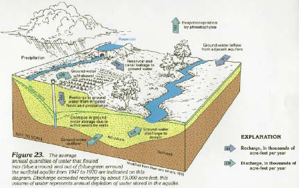
Figure 1: Water Balance of the South Platte Alluvial Aquifer showing the groundwater 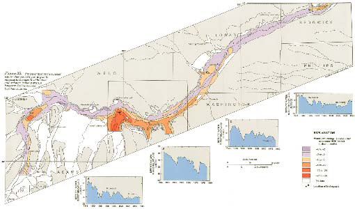
Figure 2: Water table declines in the South Platte Alluvial Aquifer during 1945-1985 |