 |
|
A winning proposal for the Innovative Research Program, 2010: 3-dimensional aircraft-based measurement of wind profiles for quantifying ozone transportInvestigators:Mike Hardesty (NOAA/CIRES) and Christoph Senff (CIRES) Collaborators:Dr. Guy Pearson (Halo Photonics) and Prof. Fay Davies (University of Salford) Prof. Rainer Volkamer (CIRES/University of Colorado) Objectives
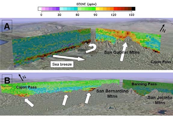
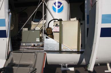
Background and ImportanceDuring recent air quality experiments, NOAA/CIRES scientists have operated the TOPAZ differential absorption lidar (DIAL) to measure ozone on a Twin Otter aircraft for characterization of the 3-dimensional distribution of ozone over metropolitan areas such as Boston and Houston. TOPAZ provides measurements of ozone concentration at high resolution (90 m vertical, 600 m horizontal) for use in characterizing horizontal and vertical structure of pollution plumes and export of pollution to regions downwind of sources. Estimates of horizontal flux of ozone are computed by measuring the total ozone in the plume and extrapolating a wind measurement, typically from a nearby ground-based wind profiler then computing the product of concentration and wind speed to estimate the flux. This method works acceptably when wind structure varies on regional or synoptic scales so that a nearby profiler measurement is representative of the wind field in the pollution plume. During summer 2010 the Twin Otter is scheduled to be deployed during the CALNEX experiment to study pollution transport and distribution over Central and Southern California. Many regions in California, in particular the Los Angeles Basin and the San Joaquin Valley, experience high ground-level ozone concentrations and are frequently in violation of the national ozone standards. The complex geography and proximity to the ocean result in very complex flow patterns on local and regional scales, which transport ozone and other air pollutants within and between the various air basins in California. For example, the mountain ranges surrounding the Los Angeles Basin and the Central Valley represent very effective barriers against horizontal transport of polluted air masses, but under certain circumstances upslope flows along the mountain flanks may provide a potentially important mechanism for exporting pollutants. Observations of these transport mechanisms are sparse and it is poorly understood when these processes occur and what their relative importance is in ventilating air basins. The complex wind structure produced in this environment will not be adequately represented by extrapolating measurements from a few nearby surface stations, wind profilers, or intermittent rawinsondes. In preparation for the CalNex 2010 project we conducted a small pilot study, during which we deployed NOAAs TOPAZ ozone and aerosol lidar on a Twin Otter aircraft and conducted several flights over the San Joaquin Valley and the Los Angeles Basin in July 2009. Figure 1 shows ozone profile measurements over the Los Angeles Basin for the 17 July flight. The measurements clearly show the complexity of the ozone distribution as a result of the interaction between sea breeze and upslope flows along the heated mountain flanks. On this day, we observed lofting by the San Gabriel Mountains of high levels of ozone from the surface into the lower free troposphere up to ~ 4 km altitude as well as upslope transport of ozone through Cajon Pass, both potentially important mechanisms for pollutant export from the Los Angeles Basin. To represent winds in the complex environment illustrated in Figure 1, we are planning to deploy a Doppler lidar, in collaboration with Salford University, on the Twin Otter alongside the TOPAZ lidar and a CIRES AMAX-DOAS instrument to measure wind profiles below the plane. The Salford Doppler lidar was tested during summer 2009 on board the Twin Otter as part of a short test program in Eastern Colorado. The lidar beam was directed transverse to the aircraft (Figure 2) providing a single component of the wind. Such a configuration enabled measurement of transverse ozone flux by flying a flight leg roughly perpendicular to the mean wind. This proposal focuses on adding a NOAA-purchased scanner to the optical path on the Twin Otter to enable full 3-dimensional wind profiles at 600 m horizontal resolution to match the ozone measurements and use the scanner with the Doppler lidar during CALNEX. The 3-dimensional wind profiles will remove the ambiguity that was present in the 2009 fixed-pointing measurements, greatly expanding the scientific value of the product. What makes this innovative?Two aspects of this work will be highly innovative: demonstration and evaluation of the scanning technique and scientific analysis of the data obtained. We will implement a scanning strategy involving 2-s observations taken at plus and minus 45 degrees off the flight path and nadir pointing. These data will be combined into 3-d wind vectors, taking into account signal strength and uncertainty in the estimate. Because the lidar line-of-sight measurements will be somewhat offset in time and space, evaluating the scanning technique will be one aspect of the work. Simultaneous measurement of wind and ozone profiles in the complex environment of Southern California will provide heretofore unavailable measurements on pollution transport and wind flow in the region. Mountain-valley and upslope flows, coupled with a vigorous sea breeze and strong capping inversion make modeling of wind flows difficult to achieve and nearly impossible to verify. No previous measurements of boundary layer 3-dimensional winds, in combination with ozone and AMAX-DOAS observations, with this coverage and resolution have been reported to date. Expected outcome and impactExpected outcome for this project will be a thorough evaluation of the scanning technique and the application of combined DIAL and Doppler lidars and an AMAX-DOAS instrument to measure pollution transport, as well as a unique data set providing quantitative information on transport of ozone, NO2, and other pollutants through the gaps and up the mountainous slopes of Southern California and the Central Valley. The data set and ensuing analysis should generate multiple publications relevant to air quality and climate issues in the California region. Research planThe research plan is heavily weighted toward summer, 2010 activities, as follows:
Figure 1: TOPAZ lidar measurements of ozone mixing ratio from ~300 m above ground to ~4 km above sea level along the flight track for two portions of the 17 July 2009 flight over the Los Angeles Basin.
Figure 2: Salford Doppler lidar installed in NOAA Twin Otter during summer 2009 |