 |
|
A winning proposal for the Innovative Research Program, 2010:
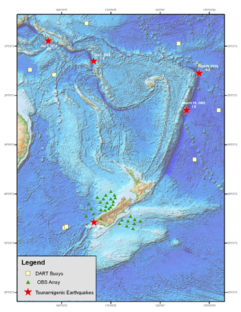
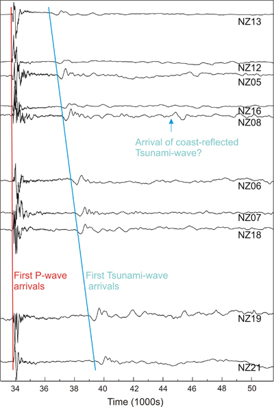
Array studies of Tsunami wave propagationInvestigators:Anne Sheehan (CIRES and CU Department of Geological Sciences) Zhaohui Yang (CIRES and CU Department of Geological Sciences) George Mungov (CIRES and NOAA National Geophysical Data Center) Kelly Stroker (NOAA National Geophysical Data Center, Boulder) Objectives:We will use data from a one-year deployment of ocean bottom seismometers and pressure sensors offshore New Zealand to study the characteristics and spatial transformation of tsunami waves over the continental shelf and slope where the most significant tsunami wave changes take place, with the ultimate goal of validation of tsunami numerical models leading to more accurate tsunami warnings. Background and importance:In 2009, CIRES Fellows Anne Sheehan and Peter Molnar, along with colleagues at Woods Hole and MIT, deployed 30 ocean bottom seismometers (OBSs) and differential pressure gauges (DPGs) on the continental shelf and slope offshore New Zealand. The goal of the ocean bottom seismometer study was to explore the deep structure under the New Zealand transform plate boundary (the Alpine Fault) using seismic tomography [Molnar et al., 1999]. The array of OBSs and DPGs fortuitously recorded both seismic signals and tsunami wave signals of five tsunamigenic (tsunami producing) earthquakes during the one-year deployment. The most notable of these were the July 15, 2009 magnitude 7.8 earthquake offshore New Zealands South Island, and the September 29, 2009 magnitude 8.0 Samoa earthquake. Earthquakes still cannot be predicted, but the tsunamis generated by vertical displacement of the seafloor by earthquakes can be rapidly modeled, and these models are used to issue watches, warnings, and evacuations [Titov and Gonzalez, 1997; Synolakis et al., 2007]. The devastating 2004 Sumatra tsunami was especially tragic because of the lack of an effective tsunami warning system for the Indian Ocean. More recently, the February 27, 2010 magnitude 8.8 Chile earthquake generated a destructive tsunami for coastal Chile. The initial tsunami forecast for the Chile earthquake was based upon the earthquake source model and later refined by the tsunami wave measured at a NOAA DART (Deep-ocean Assessment and Reporting of Tsunamis) bottom pressure recorder offshore northernmost Chile. The tsunami warning for Hawaii and the western Pacific, while accurate in terms of time of arrival of the tsunami waves, overestimated the amplitude of the tsunami waves. This overestimation was in part because of (1) assumptions that had to be made rapidly between the earthquake source model and a seafloor displacement model, (2) the 3 hours it took for the tsunami waves to reach the closest DART buoy delayed the refinement of the tsunami model, and (3) the seafloor displacement was in shallow ocean so a smaller mass of water moved than if the displacement had been in deeper ocean. The DART array, completed in 2008, was developed to provide real-time tsunami detection as the waves travel across the deep-ocean [Gonzalez et al., 1998; Bernard and Titov, 2007]. Data for tsunami wave transformation over the continental shelf and slope are widely missing.
Research Plan:Because Differential Pressure Gauges (DPGs) can measure pressure fluctuation of several millimeters of water pressure [Cox et al., 1984] at similar precision as DART bottom pressure recorders (1 cm [Gonzalez et al., 1998]), DPGs can provide useful measurements of tsunami waves [Baba et al., 2004; Drushka et al., 2008]. The pressure data set from the New Zealand ocean bottom experiment provides an exciting opportunity to reconstruct the entire process of tsunami propagation and transformation from the open ocean (DARTs), through the continental shelf (DPGs), to the coast (tide gauges). We will first remove tidal signals and long term drift from the data from the CIRES/WHOI/NSF New Zealand DPG array in order to obtain the free water level oscillations (residuals) for the five earthquake-generated tsunamis recorded by our DPG array during 2009 and early 2010. Based on the tsunami signals in the DPG records, we will examine the characteristics of the tsunami waves for the study area: amplitudes and energy spectrum, and their transformation over the continental shelf and slope. We will compare the observed tsunami wave characteristics with those predicted by the PMEL (NOAA Pacific Marine Environmental Laboratory) tsunami wave model, and seek to determine the sources causing the misfit. In particular, we plan to carry out a synthetic test to explore how the orientation and rupture length of seafloor displacement, and variations in water depth near the source, affect the amplitude and propagation of near field tsunami waves. Through the synthetic tests compared with our ocean bottom data we will explore the potential of using arrays of near field tsunami wave measurements (our DPG measurements) to solve for seafloor displacements rapidly, which is difficult to resolve using traditional seismic, rather than seafloor pressure, data. What makes this innovative:This extraordinary data set represents the densest array of seafloor pressure gauges that has recorded tsunami waves in the near field covering a continental shelf and slope. The use of our seafloor pressure measurements will help bridge the gap between the earthquake source model and the tsunami model and will help us reconstruct tsunami waves from the open ocean to the continental shelf to the coastal tide gauge. Expected outcome and impact: We plan to obtain characteristics of tsunami wave transformation over the continental shelf and slope of New Zealand, determine the source of misfit between the wave heights predicted by tsunami models and our observed DPG measurements of the tsunami waves, and test the effectiveness of using DPG array data to determine models of tsunamigenic seafloor displacement. This project has tremendous potential to demonstrate the utility of arrays of near coast pressure gauges (wired as real-time) to monitor tsunamis and forecast their effects. If successful, pressure data from past ocean bottom seismic experiments could be used to further test and refine models of tsunami generation, and future arrays of DPGs can be considered for enhanced tsunami monitoring. Collaboration:This is a wonderful opportunity for collaboration between CU/CIRES geophysicists and NOAA-NGDC/CIRES marine scientists. Sheehan and Yang bring expertise on seismology, earthquake source modeling, and inversion techniques to the project, and direct experience with the New Zealand ocean bottom seismic experiment. Mungov brings expertise on seafloor pressure gauge data processing, analysis of tsunami energy (spectral) characteristics, and their transformation in time and space. Stroker provides expertise in both coastal and deep-ocean water level measurements and associated data management. Barry Eakins (NOAA-NGDC/CIRES) will provide expertise on seafloor bathymetry and its role in tsunami wave focusing and defocusing.
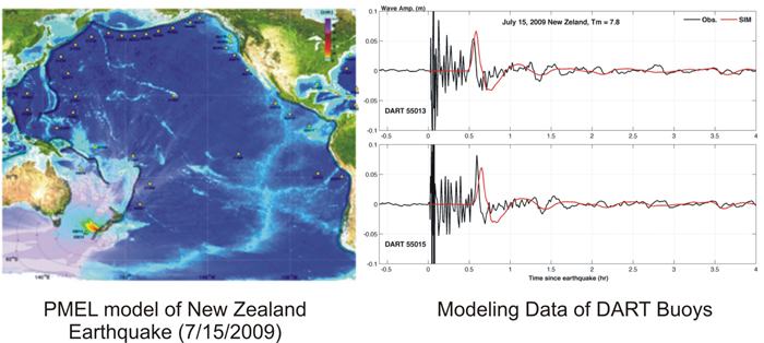
Figure 3. (left) PMEL model of tsunami from 7/09 New Zealand earthquake, and (right) observed and modeled ocean bottom pressure at deep water DART buoys. ReferencesBaba, T., K. Hirata, and Y. Kaneda, 2004, Tsunami magnitudes determined from ocean-bottom pressure gauge data around Japan, Geophys. Res. Lett., 31, L08303, doi:10.1029/2003GL019397. Bernard, E.N., and V.V. Titov, 2007, Improving tsunami forecast skill using deep ocean observations. Mar. Tech. Soc. J., 40(3), 2326. Cox, C., T. Deaton, and S. Webb, 1984, A Deep-Sea Differential Pressure Gauge, Journal of Atmospheric and Ocean Technology, 1, 237-246. Drushka, K., J. Sprintall, S. T. Gille, and W. S. Pranowo, 2008, Observations of the 2004 and 2006 Indian Ocean tsunamis from a pressure gauge array in Indonesia, J. Geophys. Res., 113, C07038, doi:10.1029/2007JC004662. Gonzalez, F.I., H.M. Milburn, E.N. Bernard, and J.C. Newman, 1998, Deep-ocean Assessment and Reporting of Tsunamis (DART): Brief Overview and Status Report. Proceedings of the International Workshop on Tsunami Disaster Mitigation, 19-22 January 1998, Tokyo, Japan. Molnar, P., H. J. Anderson, E. Audoine, D. Eberhart-Phillips, K. R. Gledhill, E. R. Klosko, T. V. McEvilly, D. Okaya, M. K. Savage, T. Stern, and F. T. Wu, 1999, Continuous Deformation Versus Faulting through the Continental Lithosphere of New Zealand, Science, 286, 516-519. Synolakis, C.E., E.N. Bernard, V.V. Titov, U. Kânoglu, and F.I. González, 2007, Standards, criteria, and procedures for NOAA evaluation of tsunami numerical models. NOAA Tech. Memo. OAR PMEL-135, NOAA/Pacific Marine Environmental Laboratory, Seattle, WA, 55 pp. Titov, V.V., and F.I. Gonzalez, 1997, Implementation and testing of the Method of Splitting Tsunami (MOST) model NOAA Technical Memorandum ERL PMEL-112, 11 pp.
|