 |
|
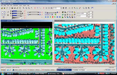
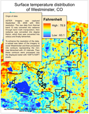
A winning proposal for the Innovative Research Program, 2010: Phenology of green infrastructure in cities: A window into ecosystem services in urban environmentsInvestigators:Carol Wessman, Ecosystem Science Division/CIRES and EBIO Brian Muller, Environmental Design, College of Architecture and Planning Brian Buma, Ecosystem Science Division/CIRES and EBIO ObjectivesWe propose to investigate remotely sensed phenology of vegetation in the urban matrix for the assessment of vegetation and associated ecosystem services in urban/metropolitan areas. Background and importanceThe dramatic increase in urbanization in developed and developing countries has far-reaching impacts on the environment and ecosystem services, affecting biogeochemical cycles, hydrologic regimes, and climate at a range of scales. Expanding urban systems, which we term emerging mega-regions, are in the process of building out under intense pressures, not only from real estate development but from policy movements to create infrastructure that is livable and adaptive to the effects of climate change and resource scarcity. Natural landscapes within mega-regions provide services that may address a variety of environmental and urban planning needs including improvement of hydrological systems, disaster risk mitigation, demand for local food and natural amenities, mitigation of climate change effects, amelioration of heat islands and carbon sequestration. We define multi-functional natural components of the urban landscape as green infrastructure. Governments of mega-regions from Chicago to Shanghai are investing substantially in green infrastructure as a strategy for adapting to climate change and addressing other environmental needs. However, the benefits of green infrastructure and associated ecosystem services have not been evaluated systematically for urban environments. More effective use of remote sensing data is critical for development of regional growth models and sustainability assessments sensitive to detailed patterns of landscape change. In a project we will be proposing to NASA this summer (invited through a reviewed letter-of-intent process), we will develop a remote-sensing and GIS-based strategy to explore land-use change and green infrastructure investment at both mega-regional and local scales. We are interested in the growth of the Colorado Front Range, an emerging mega-region that extends across two states from Pueblo, Colorado to Laramie, Wyoming. Building on morphological and landscape ecology research (e.g. Alberti et al. 1999), we are focusing on measuring changes in the form of green infrastructure as shaped by rule-based institutions. Our overall research objective is to evaluate the performance of green infrastructure under alternative development regimes in providing adaptive ecosystem services such as carbon sequestration and food production. The focus of this IRP is on the phenology of vegetation processes within the urban matrix; i.e. the phenology of the green infrastructure. Phenology is the seasonal cycle of environment-mediated physiological processes and canopy development. Phenological studies have become increasingly prominent in global change science as an independent measure of ecosystem responses to climate change (White et al. 2009). Interannual variability and decadal trends in phenology have implications for carbon sequestration, water cycles, and energy balance, and could be a window into the ecosystem services that green infrastructure provide urban environments. What makes this innovative?While there have been many analyses of built pattern (e.g., Torrens 2006) and natural amenities (e.g., Benson et al. 1998), there are significant research opportunities in the analysis of natural landscape pattern in metropolitan settings. We are developing innovative approaches to detection of urban land-use change, making use of object-based interpretive methods and nesting of higher- and mid-resolution datasets. Remotelysensed phenology has been studied at 1km and coarser resolutions at regional and global scales. However, we have not identified any studies of urban-natural gradients at higher spatial resolutions. Our focus in this proposal on the phenology of green infrastructure as a function of the morphology of the urban environment is unique, and has the potential to contribute new information on ecosystem services valued for the adaptive capacity of cities. Expected outcome and impactThere are two primary outcomes of this project. First, we will explore whether moderateresolution satellite-based time-series data and phenology metrics can be used to assess dynamics of green infrastructure in an urban environment. Second, we will evaluate how these metrics relate to urban development pattern. These findings will form a basis for a benefit analysis of green infrastructure for urban sustainability and provision of ecosystem services, our objective for a future NASA proposal to the Land Cover / Land Use Change Program. The implications are many, including understanding the carbon sequestration potential of the urban environment, water use/demand, the capacity for urban vegetation to reduce the urban heat island effect, and the less tangible influence of vegetation on environmental quality and human well-being. We expect the insights we gain will be of significant value to policymakers and researchers seeking to improve quality of life and sustainability in large and dense mega-regions. Research PlanOur remote sensing approach to emerging mega-regions employs multiple interpretation strategies to detect landscape change at both regional and sample area scales. In this proposal we focus on green infrastructure phenology across an urban-rural gradient. We have developed an object-based method for analysis of Quickbird, LIDAR and other datasets to generate high resolution, three-dimensional descriptors of the morphological and vegetative structure of urban subdivision types (Fig. 1). We are evaluating these vegetative structures across a sample of urban areas to assess social and biophysical drivers of urban landscape change, and the effect of vegetative structure on key climate change adaptation variables including storm water impoundment and heat islands. With respect to analysis of heat island effects, for example, we detect temperature distributions using ASTER data (Fig. 2) and compare these to detailed subdivision morphologies. In this IRP project, we will evaluate phenological dynamics across suburb developments of various ages in Westminster, the case study area for our other efforts, and compare them to nearby landscapes bearing native grasslands (in this case, Rocky Flats National Wildlife Refuge). We will examine NASAs MODIS 250-m vegetation index data provided at 8-day intervals for the period 2000-2009. We will use curve derivatives to identify critical points that correspond to seasonal phenomena, such as start, peak, end, length and amplitude of the growing season. We will employ a change vector analysis to investigate differences among sites along the urban-rural gradient over the past decade to observe response to precipitation patterns. Our phenological metrics will be compared to our high spatial resolution morphological and vegetation structure datasets currently under development and to vegetation cover data from coarser resolution Landsat imagery that we will develop under this project. The Landsat analyses will be a basis for extending this case study to the Colorado Front Range mega-region. These analyses will give us insight into the character of green infrastructure with respect to subdivision morphology and will form a foundation for our assessment of the adaptive ecosystem services provided by green infrastructure across the region.
Fig. 1. Object-based footprint analysis using Quickbird.
ASTER imagery from 9/9/2008. at 90m resolution. ReferencesAlberti, M. 1999. Urban patterns and environmental performance: What do we know? J Planning Education and Research 19(2): 151-163. Benson, ED et al. 1998. Pricing residential amenities: The value of a view. J Real Estate Economics & Finance 16(1):5-73. Torrens, P. 2006. Simulating spawl. Annals of the Assoc of American Geographers. 96(2):248-275. White, MA et al. 2009. Intercomparison, interpretation, and assessment of spring phenology in North America estimated from remote sensing for 1982-2006. Global Change Biology 15:2335-2359. |