Research Theme: Geodynamics
Gaining a better understanding of convection within the Earth's mantle, and of how convection affects the surface of our planet.
Why this Research Theme?
 The mantle extends from the top of the Earth's liquid core at a spherical radius of about 3500 kilometers up to the Earth's surface at a radius of about 6400 kilometers. It behaves as a solid at time scales over which we live, but convects as though it were fluid over geological time scales. As yet, neither mantle structures nor convection processes are well understood.
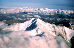
Its convective motion, on the order of a few centimeters per year, causes oceans to open and close, continental plates to drift across the Earth's surface, and the Earth's crust to buckle and deform creating mountain ranges and other structural features. Convective displacements underlie earthquake and volcanic activity. The convective process plays an indirect but fundamental role in determining the Earth's climate through its impact on surface topography.
How We're Doing this Research
CIRES studies of Geodynamics focus on mantle convection and deep earth seismology, plate motions and plate boundary deformation, geochemistry of continental evolution, mechanics and hydrology of surface fractures, erosion, mountain buildingand climate, and monitoring mass movements.
Objective
The goal of research within the Geodynamics theme is to improve our knowledge of the internal and surface processes of the planet, including links between geophysical processes and people.
Research
CIRES research in the solid Earth reaches from the core of the Earth to the summit of Everest and above. We use seismic arrays to probe the Earth's crust and mantle through experiments in the USA and Asia. Trace isotopes are used to investigate the genesis of the Earth's crust and its evolution over time. We use satellite technology and absolute gravimetry to monitor the movements of mountains, and the convergence and flexure of plates, changes in global sea level, and variations in ionospheric electron content. Data from the GRACE mission are being used to determine changes in the amount of water stored within continental regions; combined with radar altimeter data to determine changes in the distribution of heat storage throughout the world's oceans; and to better understand the viscosity of the Earth's mantle through observations of the timevariable gravity signal over northern Canada caused by post-glacial rebound. We are investigating innovative ways of monitoring the remediation of fluid wastes underground. We are investigating erosion of the Earth's surface and how it is influenced by ice, water and biological processes. Satellite telemetry bring surface deformation data in real time from the San Andreas fault system, from the Long Valley caldera, and from tectonically active regions of New Zealand, Pakistan, Bhutan, Mexico and India.
Goals
- Increase our knowledge of the fundamental processes that drive the mantle and coremantle boundary
- Examine the chemistry and physics of nearsurface rock processes
- Revise estimates of global sea level rise
- Detect and monitor internal motions of the mantle, the presence of layering, the movements of continents and the transfer of mass between atmosphere, continent and ocean
Overview
At its most basic level, the goal of geodynamics is to better understand the process of convection within the Earth's mantle, and of how that convection affects the surface of our planet. The mantle, which extends from the top of the Earth's liquid core at a spherical radius of about 3500 km up to the Earth's surface at a radius of about 6400 km, behaves as a solid at the time scales over which we live, but convects as though it were fluid over geological time scales. The convective motion, which is on the order of a few cm per year, causes oceans to open and close, continental plates to drift across the earth's surface, and the Earth's crust to buckle and deform creating mountain ranges and other structural features. The convective displacements are the underlying source of earthquakes and volcanic activity. In fact, in an indirect but very real sense, this convective process even plays a fundamental role in determining the Earth's climate, through its impact on surface topography.
Why this is important
Most of the fundamental issues concerning the convection remain poorly understood. What dynamical processes and structural parameters determine the style and vigor of the convection? How well known are the values of the important structural parameters (e.g. mantle viscosity, plate thickness), as estimated using independent geophysical observations? How are the motions of surface plates related to flow in the deep mantle, and what can be learned about convection and tectonic processes by measuring that motion? How is the Earth layered, and what are the tectonic implications of that layering? What is the origin of various near surface geological and geochemical features (e.g. mountain ranges, magma bodies), and what do those features tell us about mantle dynamics? What determines earthquake magnitudes and recurrence times? How does the slip along a fault evolve with time during the earthquake?
GPS, absolute gravity, and other geodetic measurement techniques are being employed in the field and from space to detect tectonic motion at all scales; from the large-scale motion of plates relative to one another, to the regional deformation within individual plates and near plate boundaries, to the local motion associated with slip on individual faults. Seismic observations are being used to map out the Earth's internal structures in different regions of the globe, at depths ranging from the near surface down to at least the mid-mantle, and to estimate the characteristics of individual earthquakes (e.g. location, magnitude, slip vector). In the lab, field samples are being analyzed by isotope geochemistry to understand the process of continental evolution. The properties of rocks at high pressures and temperatures are also being studied to probe relationships between the geodynamics and wave velocities that a seismologist actually measures. Dynamical models are being employed to determine the effects of the Earth's rheological properties on various types of tectonic motion, model the mountain building process, and to improve our understanding of the fundamental, non-linear behavior of earthquakes and earthquake cycles.
The role the uplift of the Himalayan Mountains may have played in initiating the Asian monsoon cycle is being studied. The application of geochemical dating methods to ice cores is providing information on long-term global change. Results from seismic wave speeds in rocks are suggesting the possibility of using field seismic data to monitor the spread of ground water contaminants. Field geodetic measurements in southwestern Greenland indicate that its ice sheet margin is likely to have advanced by 10's of kms over the last few thousand years. Gravity measurements from satellites originally intended to probe into the solid Earth will provide even more valuable information on regional, temporal variations in such things as ocean bottom pressure, the distribution of water stored on continents, and the mass imbalance of the polar ice sheets.
More Information
For more detailed information about geodynamics research at CIRES, contact Theme Leader Roger Bilham or see this full text description for research linkages and plans.