Research Theme: Advanced Modeling and Observing Systems
Effectively characterizing and predicting the state of the Earth system on all scales using direct observations and techniques for projecting outcomes mathematically.
Why this Research Theme?
No model exists that can faithfully mimic the real world or adequately represent all important processes in modeled systems. Our ability to represent the environment and accurately forecast climate depends on our ability to measure Earth systems. Observations serve to both validate models and provide the data necessary to parameterize modeled processes.
CIRES researchers collaborate with national and international teams to assist in innovating remote sensing and in situ instrumentation and measurement techniques. Advanced observing and modeling serves a broad spectrum of science applications. Space observing techniques and technologies are a common element among most, and the remote-sensing expertise within our centers and departments forms a special strength among the disciplines at CIRES.
How We're Doing this Research
At CIRES, modeling and observations research activities are dedicated to extending current capabilities of characterizing Earth and space environments. Projects focus on: Atmospheric chemistry, the physical parameters of atmosphere and oceans, the cryosphere, data centers and data managment, ecosystem and environmental modeling, remote sensing of terrestrial properties, non-linear systems, and space weather.
Objective
One of the most over-arching themes, it includes the integration of observing and modeling systems for a variety of environmental research and operations applications. The emphasis on technology fosters interdisciplinary engineering and science collaborations.
Research
No model exists that can faithfully mimic the real world or adequately represent all interactive processes in modeled systems. To represent the environment and accurately forecast climate depends on our ability to measure Earth systems. Observations serve to both validate models and provide the data necessary to parameterize modeled processes. Advanced modeling and observing serves a broad spectrum of science applications for a variety of environmental research disciplines. Within CIRES, modeling efforts deal with data assimilation applied to space weather forecasting, forecasts of the geomagnetic environment, air quality forecasting, and investigation of the effects of clouds and aerosols on climate, among others. Instrumentation for more rapid and accurate real-time sampling of the atmosphere has been developed to better study the environment, and understand the complex processes at play within it. Accurate observations of the state of the Earth system are critical to provide information on the spatial and temporal variability of geophysical parameters, which can be used to improve understanding of fundamental processes, to provide input and updated data to mathematical models, and to validate mathematical or conceptual models of simple or complex processes. To effectively move forward in characterizing and predicting the state of the Earth system on all scales, strong research efforts aimed at improving models and observational techniques, and at enhancing the coupling between models and measurements, are essential.
Current research projects within this theme include model development and validation relating to chemical transport, climate prediction, space weather analysis. Accurate modeling depends on good data management and availability, a focus of CIRES activities. Observing activities are wide-ranging, and include instrumentation for atmospheric observation and analysis, surface radiation, sensor and technique development, integration of multiple observation types, and ionospheric observing systems.
Goals
- Develop new measurement techniques
- Develop new instrumentation
- Advance theoretical understanding
- Improve measurements and models of important cryospheric, atmospheric and land surface parameters
- Refine data management, assimilation and analysis methods
- Ensure the preservation of important insitu and satellite observations and continuing long data time series through effective data management
- Investigate the use of hyperspectral imaging as a standard technique for remote observation of the Earth
Overview
Several research initiatives and ongoing projects in CIRES are currently using advanced observing and modeling techniques. It is our aim to make use of this synergism and to promote cross-discipline discussions and collaborations in this field.
Atmospheric Chemistry
Research is focusing on improving observations of important chemical species, aerosols and their precursors, with emphasis on remote measurements, miniaturized instruments for deployment on kites or small aircraft, fast response observations, and high sensitivity. Specifically, fast response methods are being developed to enable high-resolution observations of the temporal and spatial variability of aerosols and fine particles. New absorption techniques for characterizing the column density of chemically active and/or radiatively important compounds that influence regional air quality and climate, especially from airborne platforms, are also being pursued.
Atmosphere and Ocean Physical Parameters
The goal of this element is to investigate the use of new remote sensing methods for observing atmospheric winds and water vapor, cloud microphysical and radiative properties, and ocean surface characteristics. An important focus of this element will be the development of techniques and instrumentation suitable for mounting on ships, aircraft, remotely piloted vehicles, and kites and balloons. Another area of concentration will be the investigating the benefits of combining measurements from different sensors and numerical models to produce estimates of parameters not well measured with any single technique.
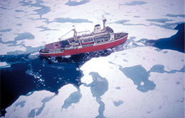
Cryosphere
The goal of this element is to improve measurements and models of important cryospheric parameters. A main focus will be assessment of data from a new generation of satellite sensors and its impact on measurements of snow cover, snow albedo, ice sheet mapping, and energy balance modeling. Modeling efforts will be conducted in parallel with observational research to parameterize snow structure, model surface energy balance based on atmospheric and cryospheric interactions, and to investigate ocean-ice-atmosphere and land-atmosphere processes. at high latitudes.
Data Centers and Data Management
CIRES is connected with several groups involved in data management that include NSIDC, CDC, NGDC and ESOC (CIRES Earth Science and Observation Center). Good data management is essential to ensuring the preservation of important in-situ and satellite observations and continuing long data time series. This is crucial for the validation and parameterization of models, data assimilation efforts, and the understanding of regional-scale processes.
Ecosystem and Environmental Modeling
The definition of objects (ecosystems) that we characterize must also be understood as changing and evolving, both in response to natural change and human influence/management. Develop new and effective methods to characterize and model managed ecosystems, prioritize management needs, and prescribe appropriate actions.
Remote Sensing of Terrestrial Properties
A goal of the research under this element is to investigate the use of hyperspectral imaging as a standard technique for remote observation of the earth. Another goal to be pursued is the application of data from the gravity mapping satellite GRACE, scheduled for launch in 2001, to estimate parameters that can be identified through redistribution of mass within the earth.
Non-linear Systems
The primary goal of this research element is to develop nonlinear Earth system models and simulations to address fundamental questions that can be understood by no other means. An important aspect of this research is cataloging and understanding the nature and configurations of space-time patterns of earth system phenomena, and examining whether these are scale-dependent or scale-invariant in space and time. This includes identification of certain characteristic patterns that may indicate smaller events precursory to more disastrous, great events such as destructive earthquakes, hurricanes, ENSO's, ozone hole, extinction events, and asteroid impacts. Other goals of this element are aimed at developing and testing potential forecast algorithms, based primarily upon the use of space-time patterns in the earth systems of interest, and understanding the physical conditions that allow space-time coarse-graining of sub-grid scale processes in simulations.
Space Weather
One goal of this element is to investigate the coupling between the various regions of the space environment, such as solar wind-magnetosphere, magnetosphere-ionosphere, and lower atmosphere-upper atmosphere. A second goal will be to develop Kalman filter and adjoint modeling data assimilation techniques, in order to parallel recent advances in tropospheric weather forecasting for optimal combination of models and data in strongly forced systems. This activity will include investigation of the infrastructure to ingest data from new satellite constellations such as COSMIC (Taiwan and US) and NASA's Living with a Star (LWS) mission.
More Information
For more detailed information about planetary metabolism research at CIRES, contact Theme Leaders R. Michael Hardesty and/or R. Steven Nerem, or see this full text description for research linkages and plans.