Map of the 1992 Rocky Mountain Front (RMF) experiment, 1994-5 Colorado Plateau-Great Basin (CPGB) experiment, permanent University of Nevada, Reno (UNR) broadband stations, U.S. National Net stations (USNSN), and other broadbands being used in studying the lithosphere of the southwestern U.S. by CU and UNR research groups.
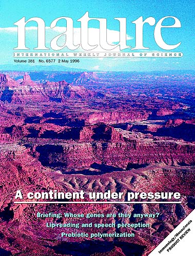
Cover photo (C. H. Jones photo): Late Palaeozoic and earliest Mesozoic sedimentary rocks of the Colorado Plateau stretch across Canyonlands National Park south of Dead Horse Point, Utah. The Abajo Mountains on the skyline are mid-Cenozoic intrusions -- a period during which the Colorado Plateau suffered little deformation. Analysis now reveals that this observation -- and the contrasting active deformation seen in neighbouring regions of the southwestern United States -- can be explained as the result of spatially varying bouyancy forces arising from differences in the thickness and density of the lithosphere.
To view the original at Nature you will have to register; the links below will get you to the relevant parts of their web page once you have registered. You can see the cover from Nature's site, or view their article summary or a summary of Phil England's News and Views article.
You can see an article in the San Francisco Chronicle about this work, or an article in the Colorado Daily (Boulder)
Other papers publishing articles from this Nature publication are the Rocky Mountain News, the Denver Post, the Sacramento Bee (all on 2 May 1996), the Boulder Daily Camera (3 May 1996), the Contra Costa (CA) Times (5 May), the Sunday San Francisco Examiner-Chronicle (5 May), the Eugene (OR) Register-Guard (6 May), the (Portland, OR) Oregonian (16 May), the Monument (CO) Tribune (23 May), the Flagler (CO) News (20 June) (most of the post-2 May stories are derived from the Sacramento Bee story). Small stories (~1 page) are have (or will) appeared in Geotimes (Sept. 1996), Discover (look for the bottom article), and Earth (Dec. 1996?).
You can get (or view) a pdf file of the comment and reply directly from GSA
Cenozoic extension in the western United States presents a complex interrelation of extension, volcanism, and plate boundary tectonics that defeats simple notions of "active" or "passive" rifting. Forces driving extension can originate at plate boundaries, through basal traction, basal normal forces, or from buoyancy forces internal to the crust and lithospheric mantle. The latter two are most responsible for driving extension where it is observed in the Basin and Range. The complex evolution of the northern Basin and Range probably represents removal or alteration of mantle lithosphere interacting with buoyancy stored in the crust. In contrast, crustal buoyancy forces combined with a divergent plate boundary between about 28 and 16 Ma to drive extension in the southern Basin and Range. The central Basin and Range most likely extended as a result of boundary forces external to itself but arising from buoyancy forces elsewhere in the western United States.
Mueller, K., G. Kier, T. Rockwell, and C. H. Jones, Quaternary rift-flank uplift of the Peninsular Ranges in Baja and Southern California by removal of mantle lithosphere, Tectonics, doi:10.1029/2007TC002227, 28, TC5003, 2009.
Regional uplift in southern California, USA, and northern Baja California, Mexico, is interpreted to result from flexure of the elastic lithosphere driven largely by heating and thinning of the upper mantle beneath the Gulf of California and eastern Peninsular Ranges. The geometry and timing of faulting in the Salton Trough and Gulf of California, the history of recent rock uplift along the Pacific coastline, and geophysical data constrain models of lithospheric heating and thinning based on unloading of a continuous elastic plate. High topography that marks the ~400-km-long rift shoulder in northern Baja California mimics the pattern of uplift observed along the Pacific coastline as defined by marine terraces. We interpret this to indicate that recent rock uplift has occurred across the entire width of northern Baja Peninsula and increases from west to east. Pliocene strata deposited at sea level along the Pacific coastline in southern California have not been uplifted significantly above Quaternary marine terrace deposits. This suggests the onset of rock uplift along the Pacific coast here is post-Pliocene and occurs after Miocene crustal extension in the Salton Trough and Gulf of California. Strong heating of the mantle lid beneath the Peninsular Ranges in northern Baja California thus coincides with crustal extension limited to localized oceanic spreading in the Gulf of California.
Schulte-Pelkum, V, G. P. Biasi, A. F. Sheehan, and C. H. Jones, Differential motion between upper crust and lithospheric mantle in the Central Basin and Range, Nature Geoscience, doi: 10.1038/NGEO1229, published online 14 Aug 2011, 2011.
Stretching of the continental crust in the Basin and Range, western USA, has more than doubled the surface area of the central province. But it is unknown whether stretching affects the entire column of lithosphere down to the convecting mantle, if deep extension occurs offset to the side, or if deeper layers are entirely decoupled from the upper crust. The central Basin and Range province is unusual, compared with its northern and southern counterparts: extension began later; volcanism was far less voluminous; and the unique geochemistry of erupted basalts suggests a long-preserved mantle source. Here we use seismic data and isostatic calculations to map lithospheric thickness in the central Basin and Range. We identify an isolated root of ancient mantle lithosphere that is ∼125km thick, providing geophysical confirmation of a strong, cold mantle previously inferred from geochemistry. We suggest that the root caused the later onset of extension and prevented the eruption of voluminous volcanism at the surface. We infer that the root initially pulled away from the Colorado Plateau along with the crust, but then was left behind intact during extension across Death Valley to the Sierra Nevada. We conclude that the upper crust is now decoupled from and moving relative to the root.
 PE) for case
(1) and a very negative
PE ( -2 x 10¹² N/m) in case (2), which would predict horizontal
deviatoric compressional stresses. Given the extensional state of stress in
most of the Plateau, a negative PE for the Plateau would indicate that either the assumptions
underlying the use of PE for estimating strain rates are flawed, or that
substantial boundary forces are presently being applied to the Plateau from the
sides and/or the bottom.
PE) for case
(1) and a very negative
PE ( -2 x 10¹² N/m) in case (2), which would predict horizontal
deviatoric compressional stresses. Given the extensional state of stress in
most of the Plateau, a negative PE for the Plateau would indicate that either the assumptions
underlying the use of PE for estimating strain rates are flawed, or that
substantial boundary forces are presently being applied to the Plateau from the
sides and/or the bottom.To resolve between cases (1) and (2), we will review previous interpretations of refraction data in the Plateau, present new constraints from receiver functions at Colorado Plateau stations from the 9 month long 1994-5 Colorado Plateau- Great Basin seismic field experiment, and consider the impact of likely crustal compositions consistent with seismic and xenolith observations on the velocity-density relation. Resolving between these models not only improves our understanding of the modern force balance on the Colorado Plateau, but it also constrains models for the Cenozoic uplift of the Plateau.
(Special WWW caption for key figure from 1995 poster:) Receiver functions from two of the Colorado Plateau stations (located on map in Jones, 1996) compared with synthetic receiver functions generated from previous refraction interpretations of the Hanksville-Chinle line across the center of the Plateau. The best interpretation appears to be Prodehl's (1979) interpretation, which had a thinner crust than the later Wolf and Cipar interpretation. The new data are thus compatible with a thinner Plateau crust, implying that the elevation of the Plateau is supported in large part by a less-dense mantle; this in turn is consistent with the extensional stress state of the crust in the Plateau.
 , and J. R. Unruh, Implications of Topography for Tectonics of the SW U.S.,
Geol. Soc. Am. Abstr. Prog., 28 (7), A-513, 1996.
, and J. R. Unruh, Implications of Topography for Tectonics of the SW U.S.,
Geol. Soc. Am. Abstr. Prog., 28 (7), A-513, 1996.A WWW version of the talk can be found here.
Levandowski, W, C. H. Jones, M. H. Ritzwoller, W. Shen, H. J. Gilbert, Buoyancy sources in the Western U.S.: Two case studies at different scales, EOS Trans AGU, 92, Fall Mtg. Suppl., abstract T11B-2308, 2011. (ePoster link)
The heterogeneous geologic history of the western U.S. invites a broad spectrum of possible ways of supporting topography ranging from orogen-scale thermal support to highly variable combinations of crustal buoyancy, mantle temperature, lithospheric composition, and convective effects. We explore the need for diverse means of support in two areas: the Sierra Nevada region with P-wave tomography and the Utah-Colorado-Kansas region spanning several provinces imaged with ambient noise tomography. Expected topography is initially calculated from crustal densities derived from seismic wavespeeds (e.g., Christensen and Mooney, 1995) combined with mantle densities inferred from wavespeeds assuming a chemically homogeneous but thermally varying mantle. This expected topography has internal uncertainties of a few hundred meters and compares well with observed topography in broad terms, but substantial deviations reflect the presence of melt and compositional variations. Predicted topography is too high in the Cascade backarc, the eastern Basin and Range, and in much of the Southern Rocky Mountains. This difference we attribute to the presence of melt of less than 0.5% of total volume, which lowers wavespeed with little effect on density. Reducing the density anomaly to account for melt can reconcile this discrepancy. Conversely, parts of the Wyoming craton and Great Plains have predicted topography lower than observed, a discrepancy most plausibly related to iron depletion of the Archean and early Proterozoic mantle lithosphere. No results to date require sublithospheric loads and probably preclude variations in topography from such loads exceeding ~0.5 - 1 km in each region. As we expand our coverage to the whole western U.S., we hope to be able to observe or limit sublithospheric loading.
Levandowski, W., C. H. Jones, L. A. Butcher, and K. Mahan, Uplift of the Colorado Plateau by lithospheric removal and minor crustal hydration: insights from quantitative density models, GSA Annual Meeting, Paper No. 316-8, GSA Abstracts with Programs,45 (7), p. 727, 2013.
Although ~2 km of Cenozoic uplift of the Colorado Plateau is indisputable, the origin of topography remains contentious. We interrogate a continental-scale density model in the western United States with an eye to understanding this elevation change. Generation of this density model leverages both the passage of the USArray seismometers across the western U.S. and improved seismic tomography techniques. Of the suite of possible differences between the modern state and that of the Cretaceous, we reject a substantial component of crustal thermal topography, mantle compositional topography, and past or present dynamic topography. Instead, we argue that thinning of the thermal boundary layer by 85-115 km since 0-70 Ma and the ensuing thermal equilibration are the dominant source (>1 km) of uplift. Additionally, we propose a minor (0-1 km) contribution from changes in crustal chemistry by hydration. These results highlight the topographic signature of mass, heat, and chemical exchange between the lithosphere and asthenosphere in continental interiors.
Butcher, L. A., K. H. Mahan, C. H. Jones, G L. Farmer, Colorado Plateau uplift through deep crustal hydration? AGU Fall Meeting, abstract T42B-0,3 2013.
The conventional view of plate tectonics restricts deformation to plate boundaries and does not account for regionally elevated topography in continental interiors. Thermal, mechanical or chemical alteration of ancient continental lithosphere is a mechanism sometimes invoked to explain intracratonic uplift in the western U.S. although the timing, extent and effects of this modification are poorly understood. Here we present new petrological and in situ geochronological data for a hydrated deep crustal xenolith from the Colorado Plateau and investigate the effects of deep crustal hydration on topography. Two distinct mineral assemblages recorded in a garnet biotite schist xenolith from the Navajo Volcanic Field, Four Corners region document hydration subsequent to peak metamorphism in the deep crust whereby the primary metamorphic assemblage (Gt Bt Ms Pl Kfs Qtz) is variably replaced by a lower-density, hydrated assemblage (Ab Ph Cc Rt). Results from forward petrological modeling constrain hydration at ≥ 20 km (0.65 GPa, 450 °C) prior to exhumation in the ∼20 Ma volcanic host. In situ Th/Pb dating of secondary monazite grains spatially associated with fluid-related plagioclase and allanite breakdown reveals a significant majority of Late Cretaceous dates from 91 to 58 Ma. These dates are interpreted to reflect a finite period of deep crustal hydration, possibly by fluids sourced from a shallowly subducting Farallon slab. Xenolith data additionally supports crustal hydration as a mechanism for producing regionally elevated topography. Fluid-related reactions in the deep crust may lead to a net density decrease as low-density hydrous phases (e.g. Ms Amp Cc) replace high-density, anhydrous minerals (e.g. Gt Fsp Opx Cpx) abundant in high-pressure, high-temperature assemblages preserved in Proterozoic North American lithosphere. If these reactions are sufficiently pervasive and widespread, reductions in lower crustal density would provide a quantifiable source of lithospheric buoyancy. Calculations employing density decreases associated with extensive fluid-alteration of a garnet amphibolite xenolith yield uplift estimates of up to several hundred meters for the Colorado Plateau.
Jones, C. H., K. Mahan, L. Butcher, W. Levandowski, and G. L. Farmer, Elevating the West: Is the answer in Plains sites? (invited) , GSA Annual Meeting, Paper 14-1, GSA Abstracts with Programs,45 (7), p.55, 2013
The diversity of tectonic and magmatic events in the western U.S. has permitted a wealth of hypotheses to flourish to explain the modern elevation of the region, from dynamic topography to crustal thickening to magmatic underplating to mantle depletion to lower crustal flow to vertically non-uniform extension to oblique transform motion to delamination/de-blobbing to mantle hydration to lithospheric erosion. Difficulty in determining ancient lithospheric structure and uncertainty in modern density structures has clouded efforts to resolve between these possibilities. Recent work building off of new surface wave and receiver function models suggests that the Cordillera overall are elevated by buoyant mantle but intra-Cordilleran variations are largely crustal in origin. However, some ambiguity exists in the eastern parts of this analysis, where one elevated region is plausibly free of many of these effects: the High Plains just east of the Rocky Mountains and, to a lesser degree, the high plateaus of Wyoming. Existing work from the Deep Probe line north from Wyoming and gravity and seismic data along a line east out of northern Colorado have suggested that the differences in elevations are generated within the crust and yet these differences must be post-Cretaceous in age. Xenoliths near the Deep Probe line suggest a progressive hydration in the lower crust from north to south, and new dates from a hydrated xenolith on the Colorado Plateau indicate substantial crustal hydration during the Laramide orogeny. Hydration of ~10 km thick layer of garnet-rich (30% modal garnet) lower crust that consumes all the garnet could produce ~0.8 km of uplift. If this underlies the Great Plains and Wyoming, it might also be an unrecognized contributor to topography farther west. The difficulty in fully testing this hypothesis lies in identifying and characterizing high-wavespeed lower crust as well as demonstrating a more widespread hydration event in early Cenozoic time.
Butcher, L. A., K. Mahan, C. H. Jones, and G. L. Farmer, Deep crustal hydration of the Colorado Plateau and implications for Laramide uplift, GSA Annual Meeting, Paper No. 14-2, GSA Abstracts with Programs,45 (7), p. 55, 2013
High-temperature, high-pressure mineral assemblages preserved in much of the North American lithosphere owe their origins to Archean and Proterozoic tectonic processes. The timing and extent to which subsequent mechanical, thermal, or chemical modification of ancient lithosphere may have occurred and how such processes contribute to anomalous deformation and topography in continental interiors is, however, poorly understood. Here we report new petrological and in situ geochronological data for a hydrated mid-crustal xenolith from the Four Corners region of the Colorado Plateau and investigate the effects of hydration in producing regionally elevated topography. A garnet biotite schist xenolith from the Navajo Volcanic field exhibits two distinct mineral assemblages: an early metamorphic assemblage (Gt + Bt + Ms + Pl + Kfs + Qtz) and a secondary assemblage (Ab + Ph + Cc + Rt + Ilm). The secondary assemblage variably replaces the peak assemblage, primarily at the expense of Kfs and Pl, and reflects late-stage fluid-alteration at depth; results from forward petrological modeling are consistent with hydration at ~25 km (0.65 GPa, 450°C) prior to exhumation. Th/Pb dating of monazite grains associated with fluid-related breakdown of Aln and Pl yields a wide range of dates, from the Paleoproterozoic to Paleocene, with a significant majority falling between 91 and 58 Ma. Late Cretaceous dates are interpreted to represent a finite period of monazite crystallization associated with hydrous alteration of the deep crust, possibly by fluids sourced from a shallowly subducting Farallon slab. These data also support crustal hydration as a mechanism for producing regionally elevated topography. Fluid-related reactions at depth can lead to a net density decrease as low-density hydrous phases (e.g. Ms + Amp + Cc) replace high-density, anhydrous minerals (e.g. Gt + Fsp + Opx + Cpx) abundant in unaltered Proterozoic crust. If these reactions are sufficiently pervasive and widespread, reductions in lower crustal density would provide a significant and quantifiable source of lithospheric buoyancy; calculations for density decreases associated with extensive hydration recorded in a garnet amphibolite xenolith from the Colorado Plateau yield uplift estimates on the order of hundreds of meters.
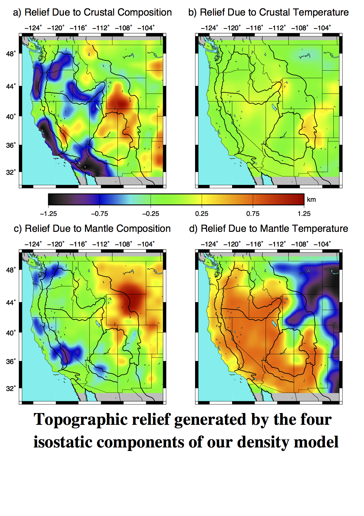
Levandowski, W, C. H. Jones, 3D density model of the western US lithosphere: Insights on chemistry, temperature, topography, and intraplate stress, AGU Fall meeting, abstract T43C-4742, 2014.
Although seismic velocity generally reflects material density, density models drawn solely from seismic interpretations suffer from the fact that temperature, melt-depletion, variations in quartz content, and in-situ melt—as well as myriad other factors—have different effects on the relationship between velocity and density. To wit, such models generally do not accurately recover gravity and/or topography variations. We have developed a probabilistic density modeling method that estimates density from seismic velocity and heat flow and refines these initial estimates in order to reproduce gravity and topography, accounting for lithospheric flexure. Both the input seismic velocity modeling and the refinement are Monte Carlo-type approaches, so the posterior distribution of models provides a direct measure of uncertainty. We leverage the aforementioned difference in sensitivity to separate density variations into thermal and compositional components, providing information on the chemistry and physical state of the crust and upper mantle. Using this approach and Transportable Array seismic data, we present a density model of the western US lithosphere (from central Kansas west) to a depth of 150 km that reveals: 1) remarkably uniform, near- to supra-solidus mantle temperatures beneath regions deformed in the Cenozoic--including the Colorado Plateau--that are ~400 °C higher than those beneath the nominally stable interior of North America; 2) crustal melt (~1%) beneath Miocene-Recent volcanic provinces; 3) depleted mantle lithosphere beneath the Wyoming craton and northern High Plains; 4) likely hydrated lower crust in the Colorado Plateau and Great Plains; and 5) that horizontal differences in lithostatic pressure create deviatoric extensional stress of ~10 MPa in the northern Basin and Range and along the margins of the Colorado Plateau. This density model is a rich source of information, shedding light on the causes and consequences of tectonism, crust-mantle interactions, and topography in the western US.
Jones, C.H., W. Levandowski and K. Bogolub, A Plains attack on the Cordillera, Geological Society of America Abstracts with Programs. Vol. 48, No. 7, paper 203-7, doi: 10.1130/abs/2016AM-287793, 2016
The western U.S. is a menagerie of thrust- and normal-fault-bounded mountains, high plateaus, lava plains and sedimentary basins. Underlying all of this is a very wide, fairly high region that seems to call out for a more unified origin than the complex surface geology suggests. Uncertainty in many of the impacts of known geologic events has clouded our ability to discern this broader origin, if indeed such an origin exists. We discuss some results from two different approaches to understanding the origins of topography in this region to try to identify any elements common to uplift in the west: a surface-based approach to removing what we know has happened, and a seismological approach to try and constrain what is there today. The first, discussed more in a separate presentation by Bogolub et al., removes sedimentary and modern flexural loads to see what topography remains. Although results in mountains are very uncertain in our early analysis, the western Plains looks to need 900-1000m of support beyond that of flexure and sedimentation. The second approach converts seismic velocity structures to density variations over a greater range of latitude. For this, we ignore the thrust-bounded mountains and focus on the more uniform and less deformed Plains and Colorado Plateau. The western Plains looks to be fully supported by variations in density within the crust and possibly the very uppermost mantle. Similar to our conclusion from the other approach, some 800-900m of support comes from levels below the surficial sedimentary rocks. We find that the seismological results indicate that support comes from above ~55 km depth; a very similar amount helps support the Colorado Plateau, though the Plateau also benefits from ~400m of thermally supported elevation. Given the similar values, it seems likely that the Southern Rockies in Colorado and New Mexico might also have benefited from a similar source of support within or at the base of the crust, at least up until substantial modification by rifting processes in the past c. 20 Ma. Working in from the least complex parts of the orogeny will, we hope, tighten the bounds on any other mechanisms operating within the interior of the Cordillera.
Bogolub, Kyren, and C. H. Jones, Decoding cryptic topography in the High Plains of Colorado, Geological Society of America Abstracts with Programs. Vol. 48, No. 7, Paper 317-6, doi: 10.1130/abs/2016AM-287837
The cause of uplift of the High Plains in the central United States is a complex and stubborn mystery. Rather than testing a single overall explanation, we approach the problem incrementally by removing topographic contributions that can be identified in surface geology. This allows us to present the truly unexplained topography. In order to constrain the amount of this unexplained, or cryptic, topography we have begun to quantify uplift that has resulted from measurable events. Although eventually we hope to study the whole of the High Plains, here we consider the area in the vicinity of Denver. The Dakota Group was deposited near sea level during the late Cretaceous. Therefore, these rocks serve as a reference from which we have studied subsequent geologic events and their effects on surface topography. If removing all known effects restored the Dakota to its depositional elevation, no further explanation would be necessary. Alternatively, any difference between the restored Dakota and its depositional elevation would reveal our cryptic topography. First, we constrain the thickness and density of the sediments that overlay the Dakota in eastern Colorado and western Kansas from well log records. From these records we calculate a load estimate, which we use in flexural deflection calculations. The load on the western end of the High Plains, the Rocky Mountains, will affect deflection calculations. Estimating this load is challenging because thrust faulting and other geologic deformation create uncertainties in reconstructing this orogen. We create 2D, cross-sectional models based on published cross-sections to infer the characteristics of the Rocky Mountain load and to calculate the flexural response of the crust to this load. With these models we are able to compare the tradeoffs between these parameters to describe uncertainties in our assumptions. These parameters can then be used in our ongoing analysis of the uplift of the High Plains. Our results are most robust in the High Plains, where it appears that ~900-1000m of topography from 105° to 102°W (i.e., the Colorado High Plains to the Kansas border) require some subsurface load. We present preliminary results of these models for several east-west sections across the Front Range and High Plains in Colorado and eastern Kansas.
Back to the last research page
Last modified at