Continent-Continent Collision along the Southern North American Margin: The Ouachita-Marathon Orogeny
The correlation of timing, rates, and distribution of deformation between Ancestral Rocky Mountain structures and the more southeasterly Ouachita-Marathon features have suggested a causal relationship to many workers seeking an explanation for the existence of the Ancestral Rockies. Kluth (1986) claims that the western margin of North America was in a period of relative quiescence during the late Paleozoic; the Mississippian Antler Orogeny had ceased, and the Mesozoic Sonoma Orogeny had not yet begun. Tectonic forces large enough to drive the basement uplifts of the Ancestral Rockies must have therefore originated along the southern or eastern margins of North America. The Alleghenian Orogeny that was actively creating the Appalachian Mountains to the east was too far removed for significant deformational stresses to be translated to the Ancestral Rocky region. The Ouachita-Marathon Orogeny, on the other hand, involved the progressive east-west suturing of South America-Africa with the southern margin of North America. Stresses could have been transmitted northward and westward into the foreland and focused along pre-existing zones of weakness that were reactivated to form the Ancestral Rockies and their associated basins (Figure 1).
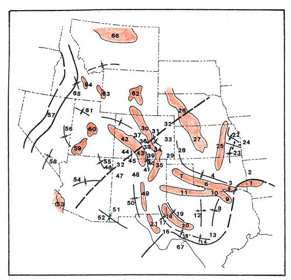
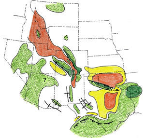
Figure 1 - Locations of uplifts (red), basins, and other features. 1. Ouachita Mountains; 2. Arkoma basin; 3. Arbuckle Mountains; 4. Anadarko basin; 5. Criner Hills uplift; 6. Wichita Mountains; 7. Amarillo Mountains; 8. Fort Worth basin; 9. Muenster arch; 10. Red River uplift; 11. Matador arch; 12. Bend arch; 13. Llano uplift; 14. Kerr basin; 15. Val Verde basin; 16. Marathon uplift; 17. Delaware basin; 18. Central Basin platform; 19. Midland basin; 20. Fort Stockton-Ozona "high"; 21. Diablo platform; 22. Forest City basin; 23. Cherokee basin; 24. Bourbon arch; 25. Nemaha ridge; 26. Cambridge arch; 27. Central Kansas uplift; 28. Hugoton embayment; 29. Keyes dome; 30. Frontrange uplift; 31. Denver basin; 32. Transcontinental arch; 33. Las Animas arch; 34. Apishapa uplift; 35. Sierra Grande uplift; 36. Central Colorado trough; 37. Sawatch uplift; 38. Hartsel uplift; 39. Sangre de Cristo uplift; 40. Cimarron arch; 41. Rowe-Mora (Taos trough) basin; 42. Uncompahgre uplift; 43. San Luis highland; 44. Paradox basin; 45. Sneffels horst; 46. Defiance uplift; 47. Zuni uplift; 48. Joyita uplift; 49. Pedernal uplift; 50. Orogrande basin; 51. Florida uplift; 52. Pedregosa basin; 53. Ensenada land; 54. Arizona sag; 55. Black Mesa sag; 56. Ely basin; 57. Antler orogenic belt; 58. Bird Springs basin; 59. Piute uplift; 60. Emery uplift; 61. Oquirrh basin; 62. Pathfinder uplift; 63. Bannock highland; 64. Copper basin uplift; 65. Wood River basin; 66. Milk River uplift; 67. Devils River uplift. Adapted from Kluth, 1986.
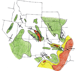
Kluth (1986) compiled a series of paleotectonic maps that show the magnitude, rate, and timing of deformational events interpreted from stratigraphic relationships during time intervals from the Late Mississipian to early Permian. An overlapping of these maps illustrates the regional relationships of structures as they changed through time, as well as their relationship to the progressive suturing to the south (Figure 2).
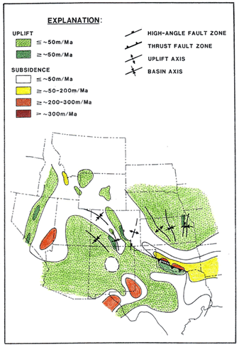
MAP 1 - Late Mississippian to Morrowan MAP 2 - Atokan
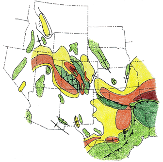
MAP 3 - Des Moinesian MAP 4 - Missourian
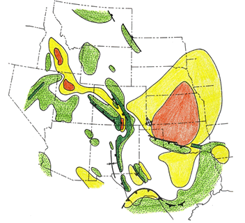
MAP 5 - Virgilian to Early Permian
Figure 2 - Series of five paleotectonic maps portraying uplift and subsidence rates in the greater Ancestral Rocky Mountain region. See summary of patterns in text below. From Kluth (1986).
Patterns of uplift and subsidence were evident but subdued before the Pennsylvanian period in Colorado, Utah, and New Mexico, but the Ouachita region of Oklahoma and Kansas witnessed the deposition of approximately 4 km of sediment during the late Mississippian period. Thick sedimentary sequences of Morrowan age in the Ouachita region provide evidence of the northward thrusting of the Ouachita belt, and by late Morrowan time, the Anadarko basin and the Criner Hills had undergone significant deformation. During the Atokan age, the Ouachita depocenter moved to the north, and deformation reached its highest intensity along the eastern margin of the Nemaha uplift and other structures in Kansas. The Anadarko basin received its first major influx of arkosic sediment due to accelerated uplift of the Amarillo-Wichita-Criner Hills belt during Atokan time, reflecting a westward and northward migration of deformation due to the progressive westward suturing of the continent-continent collision. Structural features in the Colorado portion of the Ancestral Rockies became better defined during Atokan time, with arkosic sediment filling basins adjacent to basement block uplifts. Des Moinesian time witnessed diminishing activity in the Ouachita area but intensified deformation in the foreland region of the Marathon belt. The Ancestral Rocky Mountains of Colorado, New Mexico, and Utah reached their maximum structural relief during Des Moinesian time, with the Colorado trough subsiding to form a deep, narrow depocenter between the Uncompahgre and Frontrange uplifts. During the Missourian age, uplift and subsidence rates remained high but gradually diminished in Colorado and New Mexico. Uplift in the Ouachita and Nemaha regions had become relatively minor, while deformation continued to increase in the Marathon region to the southwest. The Virgilian age reflected continental suturing in the Marathon region, with maximum intensities of northward thrusting and deformation in western Texas and southern New Mexico. Vigorous tectonic activity in the Marathon region continued into the Permian period, decreasing through the Wolfcampian and ending during the Leonardian. Uplifts in the Colorado Ancestral Rockies experienced sporadic movements through the early Permian, while tectonic activity appeared to increase in regions further to the west.
Studies of the structural trends of Ancestral Rocky uplifts have revealed a complex history of reversals of relative movement. Faults have been interpreted as high angle reverse and normal faults, thrust faults, and faults with oblique-slip motion. This myriad of trends and deformation styles, coupled with the large area (30 x 106 km2) affected by deformation, have suggested mechanisms of distributed shear to several researchers (Kluth and Coney, 1981; Kluth, 1986; Thomas, 1983; Burchfiel et al., 1992). Kluth (1986) and Kluth and Coney (1981) describe how the progressive collision of South America from east to west would have encountered a southwestward-projecting peninsula extending beyond the southern margin of North America (Figure 3). The fault-block mountains of the Ancestral Rockies may have formed through wrenching and translation distributed through the midcontinent due to N-NW-directed compressive stress focused upon this peninsula.
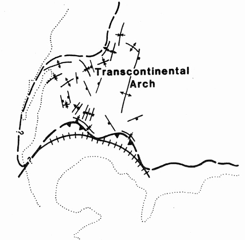
Figure 3 - Middle Pennsylvanian to early Permian tectonic features of North America, emphasizing the southwest-trending peninsula deformed during the Ouachita-Marathon Orogeny. From Kluth (1986).
Thomas (1983) describes how convergence along an irregular continental margin affects the transmission of stress into foreland areas of the continental crust. Recesses and salients along a continental margin will create a non-uniform stress field within basement rocks, a pattern observed along the Appalachian orogen (Figure 4). Deformed basement and cover rocks are unevenly distributed along the strike of the orogen; exposure of basement massifs correlate with structural recesses but are absent at neighboring salients. Paleozoic strain in Precambrian basement rocks is also focused around recesses. Concentration of strain at the Texas recess may have contributed to the uplift of large numbers of intracratonic fault blocks in the Ancestral Rocky Mountain region. Paleozoic reactivation of older basement structures, especially with probable changes in stress trajectories as diachronous suturing progressed along the irregular margin, may have played an important role in the creation of the Ancestral Rocky Mountains.
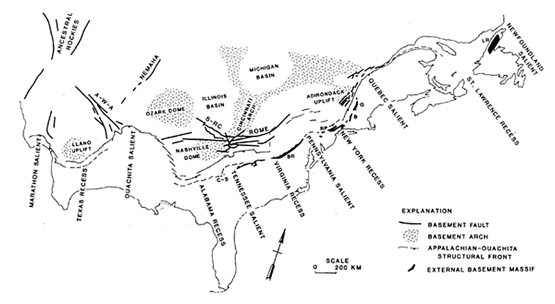
Figure 4 - Structural geology map of recesses and salients along the Appalachian-Ouachita orogenic belt during the late Paleozoic, and basement faults and arches of the North American craton. Appalachian external basement massifs: B - Berkshire; BR - Blue Ridge; C-S - Corbin-Salem Church; G - Green Mountains; LR - Long Range; RP - Reading Prong. Intracratonic basement faults: A-W-A - Arbuckle-Wichita-Amarillo; S-RC - Shawneetown-Rough Creek. From Thomas (1983).
In the search for modern analogs that might shed light on puzzling ancient orogenies, the deformation of the Ancestral Rockies has been compared to that of Asia in response to the Cenozoic Indian-Eurasian continental collision (Figure 5). The model of "escape tectonics" proposed by Molnar and Tapponier (1975) features large areas of continental foreland deforming through strike-slip, reverse, and normal faulting styles, with faults striking both perpendicular and parallel to the direction of stress. The mechanisms of intraplate deformation are just beginning to be understood; as more studies elucidate this field, more may be understood about the enigmatic Ancestral Rockies.
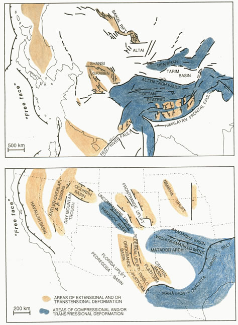
Figure 5 - Comparison of Cenozoic tectonics in Asia with Pennsylvanian structures of the Ancestral Rocky Mountains. From Miller (1992).