 |

|
| Molnar Home | Research Projects | Publications |
| RESEARCH GROUPS @ CIRES > |
Asia kinematicsKinematics and dynamics of continental deformation
Collaborators (recent past and present)
We continually update evidence for rates of deformation in Asia in order to construct a field of deformation for that region. We are testing the idea that continental deformation is best described by continuous deformation of a viscous fluid, if with blocks of crust on top of that deforming fluid. If this idea is correct, then rates of deformation respond to a smoothly varying stress field across Asia and to a smoothly varying viscosity field. This work has involved the compilation of rates of slip on major faults and the computation of an internally compatible (in the sense of Saint Venant) strain-rate field [England and Molnar, 1997a, 2005]. We also work with GPS velocities, such those from the Chinese CMONOC array (Figure 1) [Zhang et al., 2004], data obtained in collaboration with Indian [e.g., Jade et al., 2004] and Pakistani colleagues, and in a project just starting with colleagues from Tajikistan and Kyrgyzstan. A result that differs from what others report is that velocity fields that we deduce from Quaternary faulting and from GPS measurements differ little, both on the scale of Asia as a whole [England and Molnar, 2005], and in specific regions, like the Tien Shan [Abdrakhmatov et al., 1996; Thompson et al., 2002] and for Karakorum fault in western Tibet [Brown et al., 2002, 2005; Jade et al., 2004]. In doing this, we challenge some published rates; for instance, [Zhang et al. [2007] find no convincing evidence for a slip rate on the Altyn Tagh fault in excess of ~10 mm/yr. Among results from this work, we found that the strain-rate field that we obtain matches that predicted by the equation of equilibrium for a thin viscous sheet in a gravity field, and hence the idea that we can describe deformation in terms of a continuum pass this test [England and Molnar, 1997b]. The velocity field that we calculate from Quaternary faulting agrees with the GPS velocity fields, suggesting that rates obtained for several year periods do not differ from those appropriate for thousands to tens of thousands of years [England and Molnar, 2005]. The velocity field near a major strike-slip fault in Tibet implies that the crust of Tibet must include a low-viscosity zone in the middle to lower crust, but the viscosity is not unusually low [Hilley et al., 2005] We have been working separately in India and Pakistan, on separate studies. In Pakistan Nicole Feldl, while a student here in Colorado, and our Pakistani colleagues installed a network of GPS control points to study the thrusting of the Potwar Plateau and Salt Range onto the Indian Shield in northern Pakistan. Our main goal is to determine whether such thrusting occur aseismically by steady creep within the salt layers or in earthquakes. Becky Bendick and Roger Bilham have analyzed these data and have preliminary results. Finally, we (Becky Bendick, Anatoli Ischuk, Umed Saidulloev, Gennady Schelochkov, Aleksandr V. Zubovich, and I) have installed the beginnings of a GPS network in Tajikistan and adjacent Kyrgyzstan. The network includes 4 continuously recording stations, and so far 25 campaign sites. Initial measurements will be made in the autumn of 2007. Our goals include examining possible continental subduction beneath the Pamir, quantifying movements within the Tajik Depression, and assessing the extent to which the Pamir behaves as a rigid block or a large piece of Camembert cheese, somewhat smaller than Tibet. 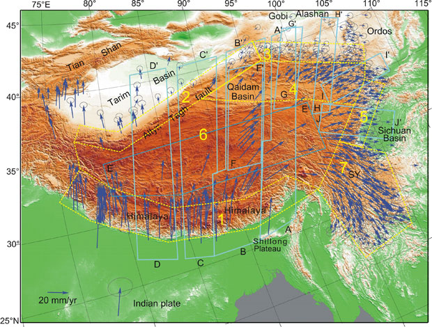
Figure 1. Global positioning system (GPS) velocities (mm/yr) for control points in and around the Tibetan Plateau with respect to stable Eurasia, plotted on shaded relief map using oblique Mercator projection about the present-day axis of rotation for India with respect to Eurasia. Ellipses denote 1s errors. Blue polygons show locations of GPS velocity profiles in other figures in the paper by Zhang et al. [2004]. Dashed yellow polygons show regions that we used to calculate dilatational strain rates (again, see Zhang et al. [2004]). Yellow numbers 1-7 represent regions of Himalaya, Altyn Tagh, Qilian Shan, Qaidam Basin, Longmen Shan, Tibet, and Sichuan and Yunnan, respectively. ReferencesChampagnac, J.-D., D.-Y. Yuan, W.-P. Ge, P. Molnar, and W.-J. Zheng (2010), Slip rate at the northeastern front of the Qilian Shan, China, Terra Nova, 22, 180-187. Gillespie, A., and P. Molnar, Asynchronous maximum advances of mountain and continental glaciers, Rev. Geophys., 33, 311-364, 1995. Hallet, B., and P. Molnar, Distorted drainage basins as markers of crustal strain east of the J. Geophys. Res., 106, 13,697-13,709, 2001. Mohadjer, S., R. Bendick, A. Ischuk, S. Kuzikov, A. Kostuk, U. Saydullaev, S. Lodi, D. M. Kakar, A. Wasy, M. A. Khan, P. Molnar, R. Bilham, and A. V. Zubovich (2010), Partitioning of India-Eurasia convergence in the Pamir-Hindu Kush from GPS measurements, Geophys. Res. Lett., 37, L04305, doi:10.1029/2009GL041737. Molnar, P; Stock, JM (2009), Slowing of India's convergence with Eurasia since 20 Ma and its implications for Tibetan mantle dynamics. Tectonics, 28 , Art. No. TC3001, doi: 10.1029/2008TC002271 |
 Supported by various grants from NSF's Theoretical and Experimental Geophysics Program