|

|
| Molnar Home | Research Projects | Publications |
| RESEARCH GROUPS @ CIRES > |
New Zealand anisotropySupported by NSF's Continental Dynamics Project Collaborators (recent past and present)
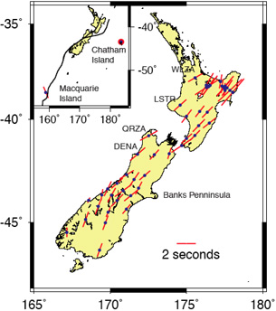
Seismology's best, and perhaps all of geophysics's only, tool for quantifying strain at depth in the earth is the measurement of anisotropy of seismic wave propagation. Olivine dominates the mineralogy of the mantle, and olivine is notably anisotropic, so that both P and S waves propagate faster in some directions, by 10% or more, than in others. Moreover, the deformation of olivine occurs so that, first, the orientation for fast P-wave propagation is aligned parallel to the axis of maximum extension in a deforming polycrystalline olivine, and, second, S waves polarized such that displacement is parallel to the axis of maximum extension travel faster than those polarized parallel to the axis of maximum compressive strain. The degree to which the mantle is anisotropic thus offers a measure, if biased, of the amount of strain that has accumulated. Quantitative relationships between amounts of anisotropy and finite strain have been developed, but because strain can accumulate in two ways, by deformation of the crystals and by recrystallization, a reliable scaling relationship between anisotropy and strain does not exist. What is needed is a field test, for which we know the strain, and we can measure anisotropy. New Zealand offers an ideal field laboratory for such a test, and making that test is one reason for working in and near New Zealand. We know well how to reconstruct relative plate motion, between the Pacific and Australia plates, and thus we can bound the total strain that has accumulated since New Zealand began to deform at ~45 Ma (Figure 1). In addition, the distortion of rock units attests to large finite strain across the islands (Figure 2). Moreover, the mantle beneath New Zealand is clearly anisotropic, as measurements of shear-wave splitting show (Figure 3).
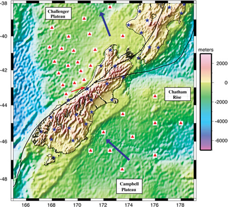
To quantify anisotropy in the mantle around New Zealand, we plan to deploy ocean bottom seismographs around the island (Figure 4). These will augment the network of broadband seismographs that the New Zealanders have already installed on land. Then with analysis of both body waves (Pn and S-wave splitting) and surface waves we hope to constrain the magnitude and orientation of anisotropy beneath New Zealand and its surroundings. In particular we hope to constrain the depth range over which anisotropy occurs. Figure 4.
 In addition to calibrating measurements of anisotropy as a strain gauge, we hope to test two hypotheses for the measured anisotropy. In one, the mantle lithosphere beneath the islands is anisotropic, because ofpenetrative deformation of the New Zealand lithosphere as the Pacific and Australia plates have slid past one another [e.g., Molnar et al., 1999; Scherwath et al., 2002]. In the other, the main fault, the Alpine fault, penetrates through the lithosphere into the asthenosphere, and anisotropy has developed in the asthenosphere as a result of shear there induced by relative plate motion. In early 2009 we deployed 30 ocean bottom seismographs around the South Island (Fig. 3), and in early 2010 recovered 29 of them. A preliminary examination of seismograms suggests that we should be able to measure shear-wave splitting, azimuthal variations in Rayleigh wave speeds, and both Pn and Sn travel times, all of which should constrain both the lateral and depth variations in anisotropy. ReferencesMolnar, P., H. J. Anderson, E. Audoine, D. Eberhart-Phillips, K. R. Gledhill, E. R. Scherwath, M., A. Melhuish, T. Stern, and P. Molnar, Pn anisotropy and distributed upper mantle deformation associated with a continental transform fault, Geophys. Res. Lett., 29(8), 10.1029/2001GL014179, 2002. |

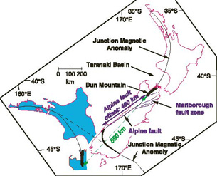 Figure 1. Simplified map of present geology (white area in red outline) and a reconstruction appropri-ate for 45 Ma (blue area in red outline). The important geologic feature shown here is the belt of ultramafic rock, the Maitai terrane, whose continuation north of the Alpine fault passes through Dun Mountain, of dunite fame (7). This belt can be traced be-neath younger sedi-ment using the Junc-tion Magnetic Anomaly of Hatherton (13). Dis-ruption of this belt by the Alpine fault implies ~460 km of displace-ment. The reconstruct-ed position (6, 7)of the area north of the Alpine fault at ~45 Ma shows Dun mountain to have lain ~850 km southwest of its present position and not adjacent to the Maitai terrane across the Alpine fault. Presumably, the ultramafic belt and the Junction Magnetic Anomaly were once aligned across what is now the southwest end of the Alpine fault. Thus, ~390 km of plate motion must have been absorbed by slip on other, necessarily minor, faults or by more continuous penetrative strain [figure from Molnar, P., H. J. Anderson, E. Audoine, D. Eberhart-Phillips, K. R. Gledhill, E. R. Klosko, T. V. McEvilly, D. Okaya, M. K. Savage, T. Stern, and F. T. Wu, Continuous Deformation Versus Faulting through the Continental Lithosphere of New Zealand, Science, 286, 516-519, 1999, modified from Sutherland].