|

|
| Molnar Home | Research Projects | Publications |
| RESEARCH GROUPS @ CIRES > |
|
PaleoaltimetryPaleoaltimetry of ancient mountain belts using paleobotany and stable isotopesSupported in the past by NSFs Theoretical and Experimental Geophysics Program Collaborators (recent past and present)
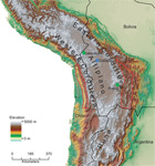
Until recently, geology lacked methods for estimating paleo-altitudes of ancient terrain. Yet, changes in elevation offer one of the most diagnostic constraints on processes occurring in the mantle beneath growing mountain ranges. Accordingly, we undertook the study of possible methods for constraining paleoaltitudes, first using paleobotany [Forest et al., 1995, 1999] and later with oxygen isotopes. The basis for the work using paleobotany includes Wolfes lifelong effort to exploit leaf physiognomy to constrain environmental parameters, such as mean annual temperature and measures of the moisture content in the atmosphere. We exploited Wolfes data base to estimate moist enthalpy (per unit mass): H = Cp T + Lv q; where H is moist enthalpy; Cp is heat capacity at constant pressure; T is temperature (in Kelvins); Lv is latent heat of vaporization, and q is specific humidity. Then, we use the moist static energy (per unit mass), h, which is a thermodynamically conserved quantity as air moves across mid-latitudes, and h = H + g Z, where g is gravity, Z is elevation, so that g Z is potential energy per unit mass. Thus, estimates of H at different sites along a latitude should give g times the difference in elevation [Forest et al., 1995, 1999]. Applications of this approach to western North America show that in early Cenozoic time, most of the west was at least as high as it is today [Wolfe et al., 1998]. The Basin and Range Province of Nevada was 1-2 km higher than today, as one might expect from the analogy with the present-day Andes [Wolfe et al., 1997]. Among quantities sensitive to elevation, oxygen isotopes offer a potentially more reliable approach than paleobotany. 18O fractionates preferentially into water vapor, and that fractionation depends on temperature so that with decreasing temperature, water vapor becomes increasingly depleted in 18O. Work of Kate Gregory-Wodzicki using paleobotany had shown that as recently as 10 Ma, the Central Andes lay no higher than 1600 m (compared with ~4000 m today) and more likely only at 1000 m. Measurements of 18O in carbonate sediment from the Central Andes corroborated Gregory-Wodzickis results and showed that the region rose ~3000 m in the short period between ~10 ands 6.8 Ma [Garzione et al., 2006]. Molnar is not pursuing work on this topic currently, but he is engaged with others who know this well. See the Northern Tibet Project.ReferencesMolnar, P; Houseman, GA; England, PC (2006), Earth science - Palaeo-altimetry of Tibet. Nature, 444 (7117) E4-E4, doi: 10.1038/nature05368
|