|

|
| Molnar Home | Research Projects | Publications |
| RESEARCH GROUPS @ CIRES > |
|
Northeastern TibetUpward and Outward: Tibetan Plateau Growth and Climate ConsequencesSupported by NSFs Continental Dynamics Project Collaborators (recent past and present)
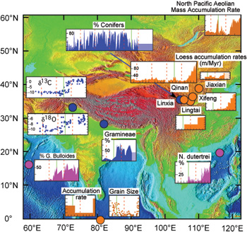
The Tibetan Plateau not only serves as the worlds best laboratory for studying intracontinental deformation, but also acts as the continents largest perturbation to atmospheric circulation. Accordingly, changes in the height or lateral extent of the plateau both should reflect deep-seated processes in the lithosphere and should affect climate. We are examining physical mechanisms that link geodynamic processes operating beneath the Tibetan Plateau since Late Miocene time to concurrent local and regional environmental changes, including a strengthening of the Indian Monsoon, the aridification of regions both south and northeast of Tibet, and an increase in aeolian deposition northeast of Tibet, and even to the North Pacific Ocean (Figure 1). For those who are interested, Molnar [2005] presents a summary of tectonic and paleo-environmental observations relevant to this topic. Mechanisms that can link the geodynamic and environmental changes include an increase in the mean elevation of the plateau [e.g., Molnar et al., 1993] and an outward growth of it by flow of lower crust that rapidly expands the area of high topography. The deformation of the region surrounding the plateau seems to have acclerated near 10-8 million years ago, and this suggests an outward, if not upward, growth of the plateau (Figure 2). This research includes focused studies (1) to determine when deformation occurred along the northeastern margin of Tibet and how much crustal shortening has occurred, (2) to date the initiation of erosion and river incision into high terrain and (3) to decipher when particular regions of high terrain began shedding debris to both nearby and distant basins, both of which will address when relief was created, (4) to map spatial and temporal patterns of environmental change, (5) to exploit geophysical data to discriminate among possible processes occurring within the crust and mantle, and (6) to understand how high topography affects regional atmospheric circulation, dust transport, and heat transport within the atmosphere. Our goals are to create images of how northeastern Tibet has grown outward and of how that growth has affected regional climate.
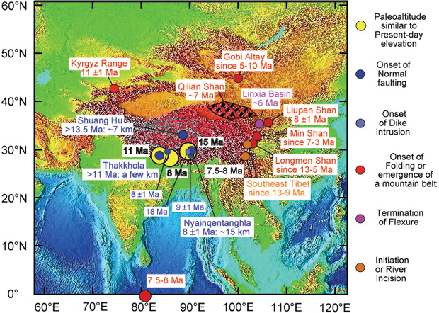
Figure 2. Map of eastern Asia showing loci of inferred tectonic developments that began within a few million years of 8 Ma, with types of observations color-coded (from Molnar [2005]). Yellow dots show three locations where Garzione et al., Rowley et al., and Spicer et al. reported elevations similar to those today at 11, 8, and 15 Ma, respectively. Dark blue dots show places where northerly trending normal faults have been dated: Shuang Hu graben by Blisniuk et al., Thakkhola graben by Coleman and Hodges and by Garzione et al., Nyainqentanghla graben by Harrison et al. and by Pan and Kidd, and two other normal faults assigned dates of 8 ± 1 and 9 ± 1 Ma by Harrison et al., and the light blue dot shows where north-south trending dikes were dated as old as 18 Ma by Williams et al. Red dots show places where folding, thrust faulting, and crustal shortening seem to have begun at in late Cenozoic time: Equatorial Indian Ocean (work of Cochran, Curray and Munasinghe, and Krishna et al., Tien Shan (work of Abdrakhmatov et al. and Bullen et al., Qilian Shan (from Métivier et al.), Gobi-Altay (from Kurushin et al.), Liupan Shan (from Zheng et al.), and the Min Shan and Longmen Shan (from Kirby et al.). The purple dot shows the location of the Linxia Basin, where Fang et al. inferred that progradation of a foreland fold-and-thrust belt and flexure ceased, and the locus of deformation moved far from this area. Brown dots show regions where Clark and her colleagues inferred late Cenozoic incision to result from a Late Miocene rise of the gentle surface of the southeastern Tibetan Plateau. Recent field work by Champagnac, Yuan, Ge, and Molnar is desgined to assess rates of slip on both strike-slip and thrust faults in northeastern Tibet (Figure 3). 
In addition to the research being carried out, CIRES's Outreach group has produced a short film for high school students entitled: "Upward and Outward: Scientific Inquiry on the Tibetan Plateau." ReferencesChampagnac, J.-D., D.-Y. Yuan, W.-P. Ge, P. Molnar, and W.-J. Zheng (2010), Slip rate at the northeastern front of the Qilian Shan, China, Terra Nova, 22, 180-187. Dayem, K. E., P. Molnar, M. K. Clark, and G. A. Houseman (2009), Far-field lithospheric deformation in Tibet during continental collision, Tectonics, 28, TC6005, doi:10.1029/2008TC002344. Dayem, K. E., G. A. Houseman, and P. Molnar (2009), Localization of shear along a lithospheric strength discontinuity: Application of a continuous deformation model to the boundary between Tibet and the Tarim Basin, Tectonics, 28, TC3002, doi:10.1029/2008TC002264. Molnar, P (2005), Mio-pliocene growth of the Tibetan Plateau and evolution of East Asian climate.Palaeontologia Electronica, 8, 8.1.2A, 23p, 625KB; http://palaeo-electronica.org/paleo/2005_1/molnar2/issue1_05.htm. |