 |
Greenland Maximum Melt Extent
A record maximum melt extent on the Greenland ice sheet in 2002
Konrad Steffen and Russell Huff
Cooperative Institute for Research in Environmental Sciences (CIRES),
University of Colorado at Boulder, CO 80309-0216
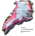
The total area of surface melt on the Greenland Ice Sheet broke all known records for the island according to scientists at the University of Colorado at Boulder. Analysis of melt extent on the Greenland ice sheet using passive microwave satellite data have shown a very dramatic increasing melt trend since 1979 which appeared to be interrupted only in 1992 by the eruption of Mt. Pinatubo. Extreme melt years were 1991, 1995, and again in 2002. This year's melt extent seems to be a new record which has surpassed the maximum extent derived from the past 24 years of passive microwave satellite data. Greenland ice sheet maximum melt area increased on average by 16% from 1979 to 2002. This year's maximum melt extent of 685,000 km2 (264,400 square miles) exceeds 2.6 times the melt area measured in 1992. In particular the northern and north-eastern part of the ice sheet experienced extreme melt reaching up to 2000 m (6560 feet) elevation. This has been confirmed with automatic weather stations on the ice sheet which are transmitting data hourly via satellite). The highest point of Greenland rises to nearly 3340 m (11,000 feet) and had never experience melt in the past 24 years according to the passive microwave satellite record.
Detection of surface melt at large spatial scales is most effectively accomplished through the use of satellite microwave data, which has a clear melt signature that arises from the transition from volume- to surface-scattering during melt onset. As such, wet-snow emission approaches black body behavior, and this change in emission characteristics is detectable by most microwave sensors. These changes in emission characteristics have formed the basis of several passive-microwave-based melt assessment algorithms.
Finally, the relationship between coastal temperatures and melt extent suggest an increase in surface runoff contribution to sea level of 0.31 mm/yr for a 1°C temperature rise according to a recent paper by Adalati and Steffen (2001). CU scientists estimate that a change in the Greenland climate towards warmer conditions would lead to an increase in the rate of sea level rise.
CIRES is a joint institute of CU
[ About CU ]
and the National Oceanic and Atmospheric Administration
[ About NOAA ]
.
Abdalati, W. and K. Steffen, Greenland ice sheet melt extent: 1979-1999, J. Geophys. Res., 106(D24), 33,983-33,989, 2001
|
Graphics
Response of the Greenland Ice Sheet to Climatic Forcing (PDF)
Melt 2002 (PDF)
Melt 2002 anomaly (PDF)
Melt 2002-3D anomaly (PDF)
Melt 1988-2002 (PDF)
Melt 1978-2002 (PDF)
Animations
Melt 1995 (MPG, 473 KB)
Melt 2002 (MPG, 489 KB)
CIRES Newsroom
Arctic Sea Ice Shrinking, Greenland Ice Sheet Melting, According to Study
Updates
Greenland Melt Extent, 2005
|