 |
|
A winning proposal for the Innovative Research Program, 2008: Development of a micro Blue / Green Laser system for Multi-Mission use by Unmanned Aerial Systems (UAS)Investigator: John Adler Objective and Importance: The objective of this project is to develop a micro blue/green laser profiler for use in multiple scientific arenas. The small size of this water-penetrating laser system will pave the way for new and innovative scientific measurements from an Unmanned Aerial System (UAS) such as: obtaining profiles of supraglacial lakes which form on portions of the Greenland ice sheet, determining actual snow depth measurements on the surface of sea ice, and determining coral reef depths in areas such as the Hawaiian National Marine Sanctuary. For the bathymetry missions, this newly developed blue/green laser profiler is expected to be integrated and tested alongside an existing small near-IR laser system developed by James Maslanik, of the CU Aerospace Department. This combination of laser altimeters will allow for direct determination of depth. The blue/green laser, operating at approximately 500 nm, will penetrate water the furthest, as shown in Figure 1, and reflect off the bottom. All other frequencies of light waves will be readily absorbed at shallower depths. This demonstrates the importance of developing a micro blue/green laser; it will be able to see further into the water. The near-IR laser will be used to record its reflection off the surface of the lake. Differencing the two will enable determination of lake depth. After flying multiple profiles, total lake volume can be calculated.
Collaborators:
Technology Development: Light detection and ranging (lidar) has been used since the 1970s in a variety of geoscience applications to measure distances between the laser and the item of interest. The distances can be determined between an aircraft and many surfaces, such as ice, land or snow. The blue/green laser systems currently in existence are large and heavy (Figure 2), unsuitable for use on a UAS. Although there are a few small near-IR laser systems, such as Maslaniks, they are constructed with existing off-the-shelf components. However, the author contacted industry representatives and discovered that a system must be custom built, since there is no current market for small blue/green laser range finders. Rough estimates over $50,000 were given to develop this commercially. Our project will reduce costs and risk by building a nadir-viewing blue/green laser profiler to obtain the range distances; we will not develop an expensive scanning unit. This simpler unit will also reduce data processing requirements since it will not rotate. Additionally, our team has strong experience with lidar use and development, including a distinguished professor in the field, and a former member of the industry.
Why it is considered innovative: This project will allow for the development of a small blue/green laser profiler (<5kg), which is not currently available in the commercial market. The small size will allow it to be integrated into an Unmanned Aerial System (UAS), along with other existing micro sensors, to obtain unique data sets unavailable via manned aircraft. For example, some small UAS have extended mission durations (>20 hours), and can operate from areas without airfields. This leads to innovative science missions such as:
Finally, this project is truly multi-disciplinary: CIRES is the catalyst, members of CU Engineering will build the device, and CU Geography students will evaluate initial results. References:
|
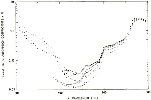
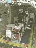 Figure 2. NASA AOL Lidar System