|
|
A winning proposal for the Innovative Research Program, 2009:
Quantification of 19th/21st century ice-volume loss in the Karakoram and Himalaya.
Investigator: Roger Bilham
Objective
To quantify glacier deflation recorded by photographic scenes captured
between 1880 and the present.
Background and importance
The Himalayan glaciers are shrinking rapidly but due to their inaccesibility only a
few of them have been studied quantitavely. The glaciers are important since
they currently provide a perennial water supply for agriculture in communities in
the Himalaya, which, if current trends continue may dry up in the next century.
We have discovered glass-plate collections of glaciers in Europe, London and
Kolkata that record oblique views of glaciers north of Everest, in the
Kanchenjunga region, in Kumaun and in the glaciers of the Karakoram. It is the
intention of David Breasheares, the mountain cinephotographer, to occupy
identical view angles and vantage points and to re-photograph these scenes to
provide the basis for a quantitative measure of glacier deflation. However, he
has no tools or experience for quantifying the scenes, and recently approached
CU to ask whether we can provide this vital component of the research project.
What makes this innovative
The photographic archive is unique, and few have access to the raw oblique
views of the glaciers. (Corona images and subsequent space photography show
glacial retreat but do not well-document the vertical ablation of glaciers). Bilham
is able to access the raw data in Kolkata and the British Library. Breaseaers has
access to collections in Zurich, Vienna and the Royal Geographical Society. The
availability of scenes at three or more times in the past century permits us to
estimate an acceleration rate in glacial ablation.
Expected outcome and impact
The pilot project (2009) would quantify mass loss in individual scenes. From
point measurements along certain valleys we would estimate mass loss in
individual glaciers (we have discussed the details of photogrammetric scaling
with Tad Pfeffer), and extrapolate this to mass loss in glacial catchments
depending on available data. We would then characterize the westward trend in
glacial loss from Sikkim to Pakistan using remote sensing (we have discussed
the details of this with Walleed Abdulati who is interested in the extrapolation
problem). The ultimate product would be a complete ice-wastage estimate for the
Himalaya (with velocity and acceleration terms) with ice-mass extinction
estimates for a half dozen glacial drainages. The estimates will provide a
measure ofthe contribution from Himalayan glaciers to decadal global sea level
rise (probably <5%).
Research plan
I propose to use a reflectorless, hand-held laser ranging device with sufficient
range (e.g 3 km) that it may be used to sight on large rocks visible in the 19th,
20th and 21st century scenes from the vantage point of the camera. The scale of
the present scene is all that is needed, since this reveals the valley profile hidden
by the ice in earlier scenes. Glacial deflation amounts to 100 m between the
1920 and 2009 scenes we have presently viewed (see examle below). The
proposed device measures distance, angle and range and provides
instantaneous measures of vertical separation without recourse to a
retroreflector. Given the deflation amount I believe measurements accurate to 1
m accuracy will be adequate and obtainable, limited by the roughness of the
surface morraine. In fact many alternative geodetic methods might beconsidered (GPS, laser ranging or barometric measurements). These are all
more or less excluded by the great difficulty associated with crossing the many
glaciers to place instruments or reflectors above the extraordinarilly perilous
lateral morraines that now line the valley sides. The morraines were much
smaller a hundred years ago.
I have been invited to accompany Breasheares to the Karakoram this summer. He
will pay expedition costs and I will in fact be visiting Karachi so that I am
requesting only the additional cost of travel to the Karakoram to meet up with his
expedition, and to visit Kolkota to make digital copies of the glass plates of the
glaciers in 1890/1910. I believe that I am the only westerner to be currently
allowed access to this collection since the partition of India. The plan would be to
work with Breashears on documenting a half dozen glaciers in the Karakoram by
training him and his Sherpa crew on how to undertake the measurements
accurately. I envisage 1 week in Kolkata gathering data and 2 weeks of overlap
in the Concordia region of Pakistan.
Data from the expedition will be used to calculate volume changes in the
Karakoram region working with Pfeffer and the Snow and Ice Center, and
probably a research student. Breasheares plans to extend the measurements
down the range towards easten Nepal and to undertake additional
measurements in the Tien Shan mountains. A probable outcome would be to
provide starting materials for a research student to assimilate the data and work
on the problem both of mass-loss, and on the physics of glacial wastage on "dirty
glaciers". Bob Anderson has several ideas on this and has identified a possible
student. Breashears plans eventually to make a movie featuring the vanishing ice
and its impact on mountain communities CU and CIRES will play a prominent
role in this movie.
|
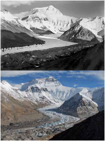
The example images are reduced from 120 Megapixel scans of the raw images taken by Wheeler (1920) and Bresheares (2007) of the Everest region. A >100 m
deflation of the glacier has occurred in 87 years. The project plans to quantify the
vertical deflation at two or three locations in each scene.
Early Photographers
Vittorio Sellas explorations were made as a recording photographer for the Duke of Abruzzi,
who organized an expedition to the Karakoram in 1909. Sella also accompanied Douglas
Freshfield on his seven-week trek around Kangchenjunga and he acted as a photographic adviser
to Gottfried Merzbacher, whose expedition was to the Tian Shan in 1902. N.A. Tombazi, "A
Photographic Expedition to the Southern Glaciers of Kangchenjunga." includes photographs of
Kangchenjunga's glacier in 1925, which will serve as data reference points twenty-six years after
the Sella photographs in 1899. Tombazi printed only 125 copies on the book, one of which
resides the CU's Nordlin library. The Kolkata archives includes the originals of phots taken by an
expedition from the GSI planned by T. D. LaTouche in 1909. It also includes Hayden's photos of
glaciers in Sikkim, Oldham phots from ladakh, and Herons photos of the north side of Everest. |
|
