|
|
A winning proposal for the Innovative Research Program, 2009:
Can sea-ice extent from the 1960s be determined from reprocessed Nimbus data?
Investigators: Walter N. Meier (CIRES/NSIDC), Dennis Wingo (NASA Ames Research Center), Mary J. Brodzik (CIRES/NSIDC)
Background
Old satellite data can now be reprocessed using modern algorithms and processing capacity that was unavailable in the 1960s. This was demonstrated by the reprocessed images taken by Lunar Orbiter 1 on August 23rd, 1966 by the Lunar Orbiter Image Recovery Project (LOIRP) at the Ames Research Center (figure 1). This image of the Earth was acquired while the spacecraft was orbiting the moon.
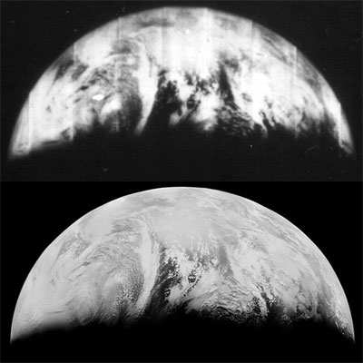
Figure 1. Comparison of original and reprocessed data from Lunar Orbiter I (1966). The original data were acquired at a distance of 385,000 km. The resolution of the reprocess data is about 1 km. (NASA, 2008)
The Nimbus I, II & III data are of a similar vintage to the LOIRP data. The Nimbus satellites carried a High Resolution Infrared Radiometer (HRIR), with a resolution of 8 km. They also carried a medium resolution infrared radiometer (MRIR) and an Advanced Vidcon Camera System (AVCS). A fortunate coincidence with these early Nimbus satellites is that they likely captured the annual Arctic sea ice minimum (occurring each September) even though they collected data for relatively short durations. Nimbus I collected data from 28 August 22 September 1964. Nimbus II collected data from 15 May 1966 18 January 1969. Nimbus III collected data from 14 April 1969 22 January 1972. Data coverage was global with twice daily acquisitions (day & night). Other related research includes an image mosaic of the Antarctic coastlines using Argon satellite photography from 1963 (Kim et al., 2007). However, this project did not involve reprocessing of original data; it used scanning versions of original Argon photographs.
Objective
In our proposed study, we will address these questions:
o Can the Nimbus data be reprocessed to enable new science?
o Do the level-0 data still exist or do we use later version from NASA archives?
o From the limited bands available can we determine average sea ice edges?
o Can we differentiate clouds from sea ice by using a time series?
Research Plan
We propose using the LOIRP data reprocessing methods to create a time series of a few HRIR images at a fixed point in the Arctic where we can identify a sea ice margin. We will make use of various algorithms to reprocess these HRIR images, depending on the version of the data available. We will search appropriate NASA archives for the original 2-inch Ampex tapes that contain the raw images and calibrations, as this form of the data offers the highest potential for success. A primary objective of the reprocessing is to remove the periodic jitter that can be seen in Figure 2. The jitter was caused by errors in
finding the horizon as the instrument scanned the surface. After reprocessing, we expect to get a few clean (enhanced) HRIR images and establish if it is possible to determine the sea ice extent. We will mask clouds using manual methods (e.g., since clouds tend to move faster than sea ice they will appear distinct from ice extent in multiple images over time). After demonstrating proof-of-concept in a select Arctic region, we will request funds from NSF and/or NASA to expand the study to determine the sea ice extent for the Nimbus campaigns (1964, 1966 and 1969). We also expect to extend our methods to later instruments to characterize minimum Arctic (and Antarctic maximum) sea ice extent for the period 1964-1978.
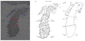
Figure 2. HRIR image of Lake Michigan. Imaged acquired October 6th 1966. The jitter is readily apparent in the resultant surface temperature plots (Noble and Wilkerson, 1970)
Importance
Due to limitations of historical program funds and processing systems, there is a wealth of early Earth-observing satellite data that were never fully explored There is a disappearing window of opportunity to recover these data, because only one tape drive remains in the world that can read the Ampex 2-inch media. Additionally, the original researchers are now mostly in their late 70s and 80s, and contact with them is critical to answering some of the necessary instrumentation questions. If this work is not done now, we will have forever lost this opportunity. Since the HRIR data coverage is global, the reprocessing techniques could make new 1960s-era data available to the entire Earth science community. The techniques we use would bring the quality of archaic data from other Earth-observing satellites (not limited to Nimbus instruments) up to contemporary standards, reinvigorating the data sets for current applications.
Why It Is Innovative
Our data mining and extraction methods will deliver new data products that have never been available, converting something of only marginal value into high-quality information. We can potentially extend the sea ice record several years back before the current standard satellite sea ice record that began in 1978. This is innovative because we are applying 21st-century processing and data handling capacity to answer a question of critical importance to modern climate change research. The images we will be recovering will be significantly better resolution than anyone has ever seen from these sensors. Finally, this project is truly collaborative: NSIDC/CIRES is the catalyst, Ames Research Center developed the algorithms, and CU students will be involved in the time-series analysis to determine sea ice extent.
Expected Outcome and Impact
This project will provide an unprecedented improvement and assessment of a unique set of historical imagery. It will recover valuable data that is in danger of being lost. The recovered data will potentially extend our record of sea ice minimum extent, a key climate indicator, more than a decade longer than currently exists.
References
1NASA, 2004. Nimbus Program History, NASA Goddard Space Flight Center.
2NASA, 2008. Lunar Orbiter Image Recovery Project (LOIRP) images, http://www.nasa.gov/topics/moonmars/features/LOIRP/.
3Kim, K., K. C. Jezek, and H. Liu, 2007. Orthorectified image mosaic of Antarctica from 1963 Argon Satellite photography: image processing and glaciological applications, International Journal of Remote Sensing, 28(23), 5357-5373.
4Noble, V. E. and J. C. Wilkerson, 1970. Airborne Temperature Surveys of Lake Michigan, October 1966 and 1967, Limnology and Oceanography, 15(2), 289-296.
|
