
What is a SNOTEL Station
The majority of data used in these images is taken from the NRCS SNOw TELemetry (SNOTEL) network -
a set of high elevation, remote hydrometeorological stations. However, I have recently added the
California Snow Survey stations and stations from British Columbia and Alberta, Canada.
The SNOTEL network became prominent in the 1980 water year when a significant number of stations
were established. Their primary aim is the to aid water resources applications.
In addition to other data, snow mass is measured by a pressure sensitive "snow pillow".
The pressure exerted on the pillow is directly related to the mass of snow.
A typical example of a SNOTEL station is shown below. You can see the silver snow pillow in the middle
of the picture and the tall brown precipitation gauge to the left.
There are over 750 operational stations across 11 US West States (including Alaska).
The NRCS has more information about SNOTEL's
How is Snow Water Equivalent (SWE) different from Depth?
Snow water equivalent, often abbreviated as "SWE", is the depth of water that would exist if all
the snow in a given column was to melt.
SWE is measured in millimeters (mm) or kilograms per meter squared (kg m-2)
SWE (kg m-2) = Depth (m) x Density (kg m-3) conversely,
Depth (m) = SWE (kg m-2) / Density (kg m-3)
Hence, the lower density the snow, the deeper it is for a given SWE amount.
So, what is the typical density of snow? Fresh snow can be anywhere from about 30 to 130 kg m-3.
The fresh snow density if a function of the type of crystals that fall and whether they are subject to
process such as wind blasting or riming.
A very simple rule of thumb for these images is to multiply the SWE amount by 10 as an approximation of
depth. A "warm" snow storm might give 8 inches of snow depth per inch of SWE, while a cold storm
with little wind that produces nice dendritic snow crystals might give 20 inches of snow depth per
inch of SWE.
Over time snow crystals metamorphose and pressure from overlying snow cause a snowpack to
become more dense than when it was fresh. Depending upon the climatic regime it has been subject to, a
seasonal snowpack will generally have a snow density of somwehere between 200 to 450 kg m-3.
Do SNOTEL stations only measure SWE?
SNOTEL stations typically measure temperature and precipitation in addition to SWE. A number of them
measure snow depth using an ultrasonic sensor (though these can often become unreliable during a storm
if there are flakes falling or blowing snow). A number of enhanced sensor sites measure quantities
such as soil temperature and moisture.
What is the quality of the data used here?
The hourly data used in the difference plots is real-time information and undergoes only minor quality control. Data used in the climatology plots and the seasonal rank plot is recorded at midnight and receives some basic quality control from NRCS. Some stations may not report every hour.
There is no guarantee that any of the data is correct - use all this information at your own risk.
Please explain the pop-up Climatology plots
|
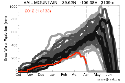
Clicking on a station's dot will display this year's snow relative to prior years.
The image shows the trace for the current water year (in red) and gives a rank (1 = lowest) for today's SWE relative to the same Day Of Year (DOY) in all prior years. Historic timeseries of SWE are colored according to their climatalogical rank of SWE for today's DOY. The darker the color, the closer that year was to the DOY median value; the lighter the color, the more extreme the value for today's DOY. Stations show anywhere from 1 to 34 years of record (as of 2013 water year). For example, the 2012 water year was particularly dry at Vail and on April 1, SWE was the lowest on record (the whole of 2012 is shown in this case). The vertical dashed line marks today's day of the year. |
|
Please explain the Seasonal Rank Status plot
The Seasonal Rank Status plot shows where the SWE quantity for today
(as a day of the year)
ranks compared to the past 25 years or more of record. A low number (e.g. black or blue color) means that
the SWE is very low compared to prior years, while a high number (e.g. red and pink color) means that
today's SWE is approaching an all time high. As mentioned, only stations with 25 or more years of record
are shown on this plot.
Please explain the Six CO Ski Area plot
This plot show the SWE for a given day of the year at the SNOTEL station closest to six Colorao ski areas.
The SWE for this year is shown with the dashed black line, while the average over all past years is in
an orange dotted line. The Berthoud Summit station is the closest to Winter Park, Grizzly Peak is
the closest to Arapahoe Basin, and Butte is next to Crested Butte.
Why make a 14 hour difference plots?
Fouteen hours is the approximate time between lift close at a ski area and the time you need to leave
Boulder for the drive up I-70! If your ski area of choice does not have a powder cam, this might give some idea of whether there will be fresh tracks available.
Who made this site?
Andrew Slater is a scientist at the
National Snow and Ice Data Center (NSIDC), which is part of the
Cooperative Institute for Research in Environmental Sciences (CIRES) at the University of Colorado. He works on cold regions terrestrial processes such as those involving snow, frozen ground and permafrost.
According to a panel of experts that were bribed with beer, he
totally rips on tele's.
These pages and images are NOT an official product, they are personal work.
... and before you head out to schralp the gnar, please check your local avalanche forecast. Happy skiing to all.
Drew