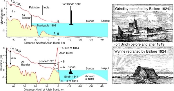
The Allah Bund before, and after, the 16 June 1819 earthquake (See Allah Bund References ). Grindlay visited the area in 1808. Contemporary descriptions of the Allah Bund's geometry are all based on Alexander Burnes' two visits (in March and August 1827 to investigate the effects of a flood in November 1826 (Lyell states erroneously that Burnes visited the Bund in 1826 and 1828)). Burnes also published a map, which was copied by Lyell (several editions) and Grant (1838). A leveling profile was measured in 1844 by Baker (1846).
Schematic sections of the Puram* river [from Bilham et al., 2007] and Fort Sindri before and after the 1819 earthquake. Baker's 1844 profile is plotted as a function of latitude (in km) from the southern edge of the Allah Bund using his map to correct for river sinuosity. The salt-water level prior to the earthquake permitted navigation to Ali Bandar with a draft of 2 fathoms at high tide (≈4 m) as claimed by Grindlay [1808] and confirmed by Burnes[1937] - see extract below. Grindlay's view of the fort was extracted by the Compte Montessus de Ballore (1924) from his original wider view (below) reproduced by Burnes which shows 5 additional boats of the sort that plied the Puram River.
*Burnes named the river through the Bund the "Koree" after the creek it feeds to the south of Lakhpat (Lucput etc) in his early maps. Grindlay and others name it the Phoran, Phurraun, Pooram or Puran (meaning new river), or Narra or Nara, both of which are tributaries that fed the stream from the north. Parts of its higher reaches are also referred to as the Goonee.
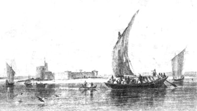
Grindlay says of Sindri: "In the evening we anchored at the turn of the tide, and at twelve o'clock next day we passed Sindree, which is about thirty miles from Lucput, and dependent on it, with a small garrison of sepoys: it is a small fort, with a few huts outside, and one well: the creek here is about a mile and a quarter broad, and has a ferry across. The travellers who take this route to Sinde are not numerous, and leave no vestige of a road in the light sand, of which the dry part of the Run is composed. The heat of the meridian sun is said to be so intense, that they generally travel in the night. From Sindree, by land, the next stage is about twenty-four miles to Baura, after which the Run ends, and water becomes tolerably plentiful. We passed Sindree, and observed several inferior branches leading through the Run, among which we saw a few straggling men and women; about twenty miles beyond Sindree, we reached Aly Bunder, at eight o'clock at night, and came to anchor close to the mound which confines the fresh water: when the day appeared, we observed it to be a poor mud village, of about fifty huts, and a tower of the same unsubstantial materials."
The passage above in red indicates our only description of the pre-1819 surface between Sindri and 32 km to the north that included the Allah Bund. The presence of a what is variously described as a village or a cluster of huts near the fort at Sindri implied the availability of fresh water, which is consistent with the well mentioned by Grindlay. Although this was almost certainly fed from the fresh water from the pre-1819 Puram/Narra river it does suggest that the sandy Sindri region was elevated above the level of the salt wastes of the Rann of Kachchh to the east. Interestingly, however, the 2 km width of the river here requiring a ferry crossing suggests a pre-1819 basin may have existed in some form.
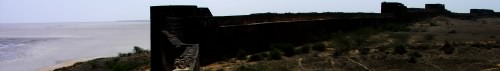
Grant published a geological map of Kachchh and the Rann in Dec 1837 (download .pdf of his memoir Geol Soc Lond.,1838) but never visited the Sindri Fort or the Allah Bund. He indicates that he saw "the ruins of one of the towers" of Sindri in January in 1834 when he visited Lakhpat 42 km to the SW. Calculations show that this was probably possible if its height was about 10 m. Grindlay's 1808 painting provides no accurate estimate of height (and like many paintings of the day shows a fictitious hill -for artistic reasons- on the horizon) but one might suppose that its walls were about 10 m and the tower 20 m. The tower would thus have guided travelers from 10-15 km distance. After the earthquake the ≈10 m high ruins of the corner walls was all that remained as suggested by Wynne's drawing. This would mean that Grant must have viewed the fort from a point in Lakhpat at least 50 m high This may have been possible from the northern walls of the Lakhpat Fort which are constructed on a bedrock ridge (north-looking photo below with Rann behind), and it is possible that the forts could have communicated with visual signals. In about 1837, Lyell asked Grant to arrange for someone to visit Sindri fort and the Bund. Grant dispatched a local surveyor in the dry season of March 1838 and found the mouth of the Pooram to be 100 yards wide with perpendicular banks 9 feet high. Local information indicated that the water was 5 feet in the channel ( 5 foot deep?) in the rainy season. Grant made a sketch of the fort from the materials given to him by his local surveyor, which Lyell reproduced in his book, but Grant does not appear to have published a quantitative survey of the Bund or Fort Sindri.
Click here and here for 51 more views of the fort and village at Lakhpat damaged by the 1819, 1845 and 2001 earthquakes.
The southern edge of the Allah Bund is variously shown without, and with, a bend, where the river disgorges into to Lake Sindri (Burnes showed both in his various publications). The concave-north bend is correct but Grant and Baker show it striking straight N110E. Of interest to recent mapping of the Bund is Burnes 1827 depiction of a stream east of the Puram which he names Kaeeramulla. The stream is a tributary sub-parallel to the front edge of the Bund just before the Narra exits into Lake Sindri. It is not mentioned in his text and he actually shows the channel north of the Bund according to his shading. However, his shading is only 1 mile wide and is obviously not meant to depict the true width of the Bund that he claims to exceed 10 miles in width. Grant shows this channel as a line separating Rann from Thurr but this is presumably conjectural since he never visited the Allah Bund. The 1880 1/4":1 mile map shows the channel but does not name it. A dry ENE tilted palæochannel starts 200 m north of the mouth of the Puram with a slope down to the WSW.
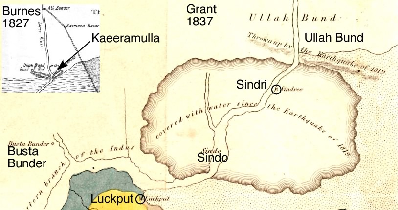
Burnes map above is extracted from Plate 16 of Oldham, R. D., [1926] which he redrafts from Burnes 1838. Grant's map ( Grant, C. W.,1837) indicates a large swath of sediment offshore. Grindlay estimates the distance from Lakhpat to Sindri as 30 miles. Busta Bunder was a ruined fort in 1819 (Carless, 1838).