Plateau Pop-up during the 1897 Assam earthquake
Roger Bilham*† and Philip
England†.
Bilham, R. and P. England, Plateau pop-up during the great 1897 Assam earthquake. Nature(Lond), 410, 806-809, 2001
*CIRES & Geological Sciences, University of Colorado,
Boulder, CO 80309-0399, USA
† Earth Sciences, Oxford University, Parks Road, Oxford, OX1 3PR, UK
The
great Assam earthquake of 12 June 1897 reduced to rubble all masonry buildings
within a region of NE India roughly the size of England, and its felt area
exceeded that of the 1755 Lisbon Earthquake[1].
Hitherto it was believed that rupture occurred on a north-dipping
Himalayan thrust propagating south of Bhutan[2],[3],[4],[5]. We show here that this view is incorrect. The
northern edge of the Shillong Plateau rose violently more than 11 m during
rupture of a buried, 110-km-long, reverse fault, dipping steeply away from the
Himalaya. The stress drop implied by the rupture geometry and the prodigious
fault slip of 18±7 m, explains observed epicentral accelerations exceeding 1 g
vertically, and surface velocities exceeding 3 m/s1.
Our finding represents the first quantitative observation of active deformation
of a "pop-up" structure, and confirms that faults bounding such structures
can penetrate the whole crust. Plateau uplift in the past 2-5 million years has
caused the Indian plate to contract locally by 4±2 mm/year, reducing seismic
risk in Bhutan, but increasing it to the large populations of northern
Bangladesh.
Central
to our analysis are the long-neglected survey reports of Captain J. Bond[6] who was assigned to locate and
remeasure the original points of the 1862 trigonometrical survey across the
Shillong Plateau. Many of Bond's team were stricken with illness, and one died,
yet despite the discovery of 8 m of uplift and 4 m of displacement of parts of
the Plateau, his results were dismissed by his superiors[7], , because they failed to
meet the triangle closure standards of the Survey of India. Bond, and later Oldham1, who attempted to interpret the
data, suspected that closure errors were caused by continuing movements
following the mainshock, an idea that was many years ahead of its time. Oldham, noting the existence of a
northward increasing strain gradient in Bond's data, recommended remeasurement
of a survey along the northern edge of the Plateau, but this was not to occur
until 19369 (Fig. 1). These northern measurements had a mean error typical of Survey of
India accuracies (3.3 µrad), but did not overlap the earlier re-survey
and, as in Bond's survey, included neither scale nor azimuth constraints.
Figure 1. Area shaken by the 1897 Assam Earthquake and location of major Himalayan ruptures in the past 200 years30. Masonry structures were damaged within Oldham’s1 intensity IX contour, and destroyed within the Intensity X ellipse. The earthquake was felt by persons within the Intensity II region. The orientation of the curious “mexican-hat” shape of the epicentral region mapped by Oldham corresponds to the strike of the causal subsurface rupture derived from geodetic data (Fig. 2).
The results of the
surveys are available as the locations of points7,[8]
with their apparent post-seismic displacements, calculated holding fixed
two points within each network1,6,[9],[10]. We seek the values of these
parameters that best fit the observed angle changes. The absence of scale and orientation information permits
only the analysis of angular changes[11],10, which we derive from these
published data.
We treat the angular changes as though they reflect deformation of an elastic
half-space, distorted by slip on a single rectangular plane representing the
1897 earthquake. In doing this we neglect deformation caused by other
earthquakes between 1860-69 and 1897 and by post-seismic deformation before the
re-surveys.
The
surface distortion caused by slip on a buried dislocation can be calculated
from nine parameters that describe its geometry and slip[12].
The problem is sufficiently non-linear that many local minima exist; we
therefore sought a global minimum by systematically searching parameter space.
Results of this search are contoured in Fig. 2b. The best fitting solution, in
the sense of minimising the misfits to the angular changes normalised by their uncertainties,
corresponds to a slip of 16 m on a fault plane striking ESE for 110 km and
dipping SSW at 57o beneath the northern edge of the plateau (Fig. 2); slip on the plane extends from 9 to 45 km beneath
the surface, with a rake of 76o.
Several features of the solution are unexpected. First, all previous
studies favored slip on a plane dipping northwards from the south of the
plateau. Furthermore, the extension of the rupture plane to the surface
corresponds to no mapped fault[13]. In the absence of a named fault
we refer to rupture occurring on the "Oldham fault". The easternmost edge of the Oldham
fault, and the latitude of its western edge, are well constrained by the
triangulation data. (Fig. 2B). The longitude of the westward termination is consistent
with 10 m of up-to-the east vertical slip on the Chedrang fault, (Fig. 2). Boundary element[14]
calculations treating the Chedrang fault as a frictionless surface driven by
coseismic stress changes caused by slip on the Oldham fault emulate the observed
distribution of slip only when the ends of the two faults approach within a few
km. Finally, the projection of the preferred rupture plane to the surface
follows slope breaks on an ESE topographic escarpment along the northern edge
of the Plateau (Fig. 2C), and follows
the strike and location of Oldham's "Mexican-hat" outline of the rupture
zone1
corresponding to the zone of highest shaking intensity and aftershock
productivity1.
(Fig. 1).
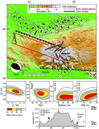
Figure 2a. Trigonometrical stations
remeasured on6 and north9 of the Shillong Plateau
following the 1897 earthquake.
Shear strains for each triangle are displayed as bars whose orientations
are parallel to the smallest (most compressional) principal strain and whose
lengths are proportional to the shear strain, G = √(g12
+ g22) where
g1= du/dx
– dv/dy, g2=
du/dy
+ dv/dx,
and u,v are components of displacement in the easterly (x) and northerly (y)
directions11. White rectangles are
calculated from the triangulation observations, and black bars show the strains
calculated for the best-fitting planar dislocation. Red rectangle indicates
subsurface location of this SW dipping dislocation; thick black line with teeth
shows the surface intersection of the continuation of this plane to the land
surface (slip terminated 9 km below the surface). Short black line at western
edge of fault plane indicates location of Chedrang fault, where Oldham1 observed 11 m of
co-seismic slip. Line with open
teeth to south of the Plateau shows location of the Dauki fault. 2b Trade-offs between parameters of the model
dislocation. Each panel displays the variation in root-mean-square misfit to
the observed angular changes, with all parameters except those illustrated held
fixed to their best-fitting values. y1 and y2 refer to latitudinal coordinate
of, respectively, the western and
eastern ends of the fault. 2c Topographic section through the central Shillong
Plateau showing projected surface location of the Oldham fault. A peneplanation surface is evident at
≈1.6 km, with isolated peaks rising to ≈2 km.
Our
best-fitting value of 16 m for the slip is one of the greatest for any measured
earthquake. A lower bound on the magnitude of this slip comes from the
magnitude of the shear strains near the top of the rupture plane (Fig. 2) and,
independently, from Oldham's observations on the Chedrang fault, which imply a
minimum of 11 m of displacement on the main fault plane. There is a trade-off
between the depth of the top of rupture and the magnitude of the slip (Fig.
2A), with greater slip (up to 25 m) allowed if the fault is buried more deeply.
Slip of less than 10 m, however, produces significantly worse fits to the
observations. The dip of the fault and the rake of the slip are constrained to
within 15o by the distribution of shear strains (Fig. 2A); specifically, a dip of less than 45o
would produce strains in the northern network that are excluded by the
data. The NNE-SSW compressional
strain implied by our rupture is consistent with the P-axes of smaller
earthquakes in the region during this century.[15],[16],[17]
The maximum depth of the lower edge of the rupture is not well
constrained by the observations (Fig. 2A). The geodetic data suggest that
rupture extended to a depth of at least 35 km, and may well have cut through to
the base of the crust (Fig. 3), here estimated to lie at 43-46 km depth[18]. This suggestion is consistent with the evidence that earthquakes occur to depths of
30—50 km beneath the Shillong plateau15. The unusually high ratio of slip to
fault length implies a static stress drop at the high end of the observed
range, consistent with the
violence of the event. It was in this earthquake that, for the first time,
accelerations exceeding 1g were identified as responsible for propelling
objects into the air. From European seismograms Richter calculated a magnitude
of Ms=8.7 although retrospective calibration of these same records yields
Ms=8.0±0.1[19].
The parameters of the rupture shown in Fig. 2 correspond to Mw=8.1.
The
triangulation data exclude significant slip on the Dauki fault, at the southern
margin of the plateau, during the 1897 event. The question remains as to
whether this undoubtedly major fault[20],[21] is a Himalayan thrust fault, as previous
interpretations of the 1897 event have concluded. In Miocene time this fault
accommodated westward translation of the Indo-Burman ranges[22], but, increasingly since Pliocene
time, the fault has permitted
reverse slip. If the Dauki fault is, indeed, a major fault bounding the
plateau, then it is reasonable to assume that, like the Oldham fault, it cuts
to the base of the crust. If the Dauki fault were a gently dipping thrust fault
(6°-15°N) it would intersect the Oldham fault in the mid-crust (6-14 km) (Fig. 3). For the two faults not to intersect within the crust the
Dauki fault would need to dip at more than 40°.
We
therefore interpret the Shillong Plateau as a pop-up structure bounded by (at
least) two reverse faults (Fig. 3). This interpretation is consistent with, but
not required by, gravity data that suggest the plateau is uncompensated15,18. It is unclear why the Shillong Plateau should be the only
major pop-up structure in the northern Indian shield. One possible explanation may lie in the proximity of two
major loads on the lithosphere that are not present elsewhere along the
Himalayan chain: the sediments of the Bengal fan are up to 23 km thick to the south
and east of the Plateau (Fig. 3), and the Indo-Burman ranges represent an
overthrust load that is moving westwards over the Indian lithosphere22.
Either, or both, of these loads may amplify the stresses already acting on the
Indian plate due to the load of the Himalaya. Alternatively, the explanation
may lie in a pre-existing heterogeneity; the Miocene strike-slip Dauki fault
may have nucleated dip-slip faulting as the region approached the Himalaya in
Pliocene time.
We now proceed to estimate the rate of uplift and shortening of the
Plateau. The time of uplift of the
Plateau has been inferred from a coarsening of sediment lithology that starts
in the Pliocene (2-5 MyBP)21. The 2-km-high plateau is surfaced by
Archæan rocks, and equivalent rocks lie 4—5 km below sea level to the north and
south of the plateau22
(Fig. 3). The mean surface level of the Shillong Plateau is approximately
horizontal (Fig. 2C), indicating that the cumulative vertical contributions of
slip on the Dauki and Oldham faults have been similar since the Plateau began
to emerge. If we assume that the relative vertical displacement between the top
of the Archæan rocks on the plateau, and their equivalents to north and south
has been caused by slip on those faults over the past 2—5 Myr, then a rate of
vertical displacement of 2.5±1 mm/yr is implied on each of the faults. Assuming
they each dip at 50o, these rates translate into fault slip rates of
3.3±1.3 mm/yr and to horizontal shortening rates of 4±2 mm/yr on the two faults
combined. These estimates are
consistent with 1997-9 GPS measurements that indicate the central Shillong
Plateau moves south at a rate of 6.3±3.8 mm/year relative to points in central
and southern India[23].
Figure 3. N/S section from Tibet to the Bay of Bengal showing
schematic geometry of Plateau pop-up.
Although the dip of the Dauki fault is conjectural, it would intersect
the 1987 rupture were its dip less than ≈ 40°, resulting in a geometry that is
incompatible with continued slip on both faults. Slip is inhibited[1]
on reverse faults with dip greater than 50°
From
these rates we estimate a recurrence interval for earthquakes resembling the
1897 event (slip≈15 m) to be 3-8 kyr on each fault. Palæoseismic investigations
along the northern edge of the Plateau indicate a 500 year interval between the
past four high-intensity shaking events[24],
but these may record accelerations from moderate local earthquakes and large
events in the Bhutan Himalaya, in addition to 1897-type events.
Our
finding of reverse slip on the Oldham fault ends a century of speculation as to
the mechanism of the 1897 earthquake. The Shillong plateau is not being built
as part of a system of thin-skinned thrusting, but is bounded by a high-angle
reverse fault to its north, and probably also to its south. The Shillong
plateau thus resembles the 'pop-up' structures that border thrust belts
elsewhere[25]. The Shillong faults, and the
smaller high-angle compressional faulting in the foreland of the entire
Himalayan arc, are located in the region flexed by the load of the Himalaya[26].
This association implies that the mechanical cause of the deformation is a
superposition of elastic stresses due to bending of the Indian plate and
in-plane compressional stress from India’s collision with Tibet. As pointed out by Rogers25,
most if not all of such structures are, or were when active, proximal to large
mountain chains that could have provided the same state of stress that drives
the uplift of the Shillong Plateau.
There is thus no need to invoke basal tractions due to subduction to
explain pop-up structures, as has often been done for the western Americas.[27],[28],[29]
The
absence of slip beneath the Bhutan Himalaya in 1897 suggests that the 400 km
region between the great Himalayan ruptures of 1934 and 1950 (Fig. 1) has
remained a seismic gap for at least the past two centuries[30]. At the higher end of our estimated
slip rates, the faults bounding the Shillong Plateau could absorb one third of
the inferred Himalayan contraction rate of 18 mm/yr[31], correspondingly increasing the interval
between great earthquakes in the Bhutan Himalaya.
Our
conclusions also raise important issues concerning the seismic hazard potential
of the Shillong Plateau. The
>300-km length of the Dauki fault has not slipped recently, but were it to
slip in a single earthquake its potential maximum magnitude (M≥8) would
constitute a significant seismic threat to nearby densely populated regions of
Bangladesh, and to the megacity of Dhaka less than 150 km to the south (Fig.
1). The interval between these
giant plateau-building earthquakes fortunately exceeds 3000 years.
Acknowledgements
The
investigation was funded by the National Science Foundation and the Natural
Environment Research Council. RB
received a John Simon Guggenheim Memorial Foundation fellowship while at Oxford
University.
Correspondence and
requests for materials should be addressed to R. B.
(email bilham@stripe.colorado.edu)