Burnes (1828) Supplementary Memoir
Pages
30-70 of A typescript copy of Burnes description of the Rann of Kachchh
1827/1828 with a note by R.D. Oldham (1924) in the Archive of the Geological
Society of London
LDGSL
767.
The
original document is listed by LaTouche on page 73 of his 1917 "Bibliography".
Burnes,
Sir A., (1828) A memoir and supplementary Memoir of a map of the Eastern
Branch of the Indus. Fol., Bombay. (the number of pages and location are not given but it
is probable that the ms lies in the Asiatic Society of Bengal and was borrowed
and transcribed at Oldham's request in 1924, by Alexander Heron, DG of the GSI).
"A
supplementary memoir to a map of the eastern Branch of the Indus with a theory
of the Runn's formation founded on facts and tradition with some remarks on the
route of Alexander the Great"
The periodical swell of the Indus is greatest in August,
and under the hope of being enabled to add something to my former memoir 1 was
induced to revisit the eastern branch of that river during the present month. Circumstances too, since
I first turned my attention to this subject, have occurred which place it in my
power to give a more full explanation of the Runn, as well in the vicinity of
the Indus, as in other parts, and as much of what I propose to advance may from
its novelty, appear theoretical, I shall endeavour to be explicit in giving my reasons
for the different conclusions. Public duty, which called me to Deesa in the
early part of this year, afforded me an opportunity of personally visiting that
part of the Runn which borders on Gujarat and extends up towards Parkur, and besides
this, I have since minutely examined the whole Northern Frontier of Cutch
bordering on its banks, as well as the different islands in it, having a view,
throughout, the illustration of its effects which have been brought about in it
by the numerous alterations of the eastern branch of the Indus, and at the same
time to establish a theory if the Runn's formations, filling etc. founded upon
such facts only as might come under my own personal observations, and which
might appear worthy of notice.
The
minuteness with which the objects on the river above Lucput were delineated on
the former map, and I can now add, from second observations, the correctness of
the situations of all of them, supersede the necessity of recapitulation on
that head in a supplementary paper like the present, but I have annexed a
reduced map of the tract to explain the subject of the Runn.
I
sailed from Lucput to Allah Bund on the 9th of August which, as may be remarked
is about the period when the southwesterly winds blow with greatest violence,
and I was therefore prepared to meet a greater body, or rather, I should say, a
greater depth, of water than when
here in March 1827 and in this I
was not mistaken. The charm which
had drawn me back had vanished, the fresh water which covered the immense tract
north of Sindree had been replaced by salt and the extent of the water on all
sides was greater and deeper that before and the prospect of Cutch regaining
that fertile tract of rice ground called Syra which it once possessed seemed
now more distant than ever.
Everything in fact, save the channel which passed through the Ullah
bund, had reverted to the state it was in prior to the inundation of November
1826. and the great influx of sea water, and the agitation of its surface by
the winds, gave the whole the appearance of a great inland sea bounding the
horizon on all sides. The decayed
tamarisk, and other stunted trees, which formerly protruded thin withered tops
and which had grown up in this land since it became one of desolation, had
disappeared under the waves, and the sailors did not, as before, follow the
windings of this once fruitful river, but bent their course by the nearest road
to their destination.
Opportunities,
however, were offered for ascertaining the depth of this channel, which I found
to be as described, only deepened by the few feet of water which had spread
likewise over the country on its banks. At Ullah Bund the river is without alteration except at its mouth
where it is certainly wider and which is to be accounted for by the west bank
being partly washed away as, instead of sloping up, it is now, like the eastern
one, perpendicular. I sailed two
miles higher up than when last here and found the water to decrease gradually
from two and a half fathoms [7.5m] to four feet [1.3m], and ultimately
terminate in half that quantity [0.6 m] which I was informed continued up as
high as Chateetur, which is above
Ally bunder and twenty miles up where the water comes from the Goonee river,
and to which the Doondees, or flat bottomed boats, could now approach. I could not learn after much enquiry that any of the
bunds or dams in this branch, in the lower parts of Sind had been repaired, and
am rather induced to believe that no alteration has been made.
The
grand bund, called Aror, the bursting of which brought about the changes before
described, had, by the accounts of all, been thrown up again, and it is this
cause that we are to attribute the disappearance of fresh water.
It
really appears a most monstrous system of policy which induces the people of
one nation to thus despoil that of another of their natural rights and to
deprive them of advantages merely to increase their own wealth. [a page of
inconsequential political comments are omitted here….
The greater distance which I ascended the river gave me a clearer
view of the effects of the Nora as the flood of
November 1826 is so called. The
banks on both sides are of clay, and as the river comes directly from the north
almost without windings, and the sides are perpendicularly cut by the violence
of the current, I can compare it to nothing so correctly as a canal, nor does
its breadth when a little way up destroy the resemblance, being only sixty feet
wide, as I found by actual
measurement.
I
might have extended my journey farther up but as I had reached the shallow
water and fallen in with a boat from Raoma Ka Bazar, the first Scandia village,
I judged it more prudent to say for myself non amplius ibes than to encounter any of the subjects of the Ameers
and, jumping on shore, I
retraced my steps to the Ullah bund.
This natural mound so called runs east to west and is certainly the
most singular effect of the great earthquake of 1891. It does not appear to the
eye more elevated in one place than another, and is a flat tract about eight or
ten feet above the level of the water with a surface of saline soil covered
with decayed tamarisk bushes, having, its elevation excepted, all the
appearance of other parts of the Runn.
I found , however, that this mound extends farther than I had before
stated for I have been credibly informed by many natives that it stretched as
far east nearly as Pachum island, a distance from the river of 24 miles, and
crosses the road over the Runn from Loona to Raomo Ka Bazar, a distance 16
miles south of the latter place, where it is about a mile broad, and during the
wet weather even made a halting place,
To the westward it is said to extend to Gharee, a distance of 18 or
20 miles which would make its total length nearly fifty miles. It is impossible to define so correctly
its breadth as it meets the land, but all describe it of the same nature as
that in the neighborhood of the river till near Khanje-Ka-Kot within two miles
or so of the Raoma Ka Bazar, which 16 miles distant from the mouth of Ullah
Bund, where the country is cultivated.
The elevation of this tract prevents the rain water from settling on
it,
so I question whether it would not now become the fertile rice country,
if the dams of the eastern branch of the Indus were laid open, instead of that
below Sindree, and between it an Lucput, which once so much befitted Cutch; for
as far yet I have had no reason to change my opinion that the country about
Sindree was lowered by the earthquake and that, unless the Indus brings down
quantities of alluvial deposit to fill up the chasm so caused (which would not
be expecting too much from such a river if again opened) it is not likely to be
ever adapted for agriculture. This
indeed would change matters as every small part of the Ullah bund belongs to
Cutch.
This Google Earth Image shows 2 mile and 3 mile radii from the confluence of the Kaeera and Puran channels. Burnes identified a damaged artificial dam 2 miles east of the Puran. Could this have been lost through northward erosion by Lake Sindri?
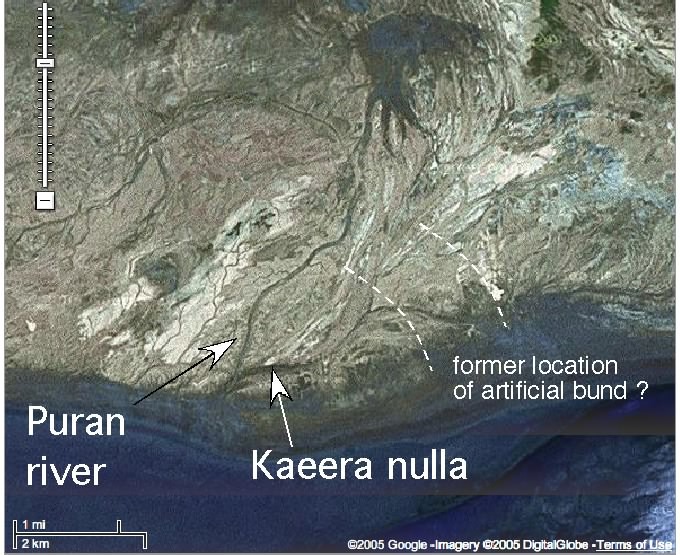
While traversing the bund, I discovered the remains of an artificial
mound on the eastern side of the river about 2 miles from the mouth of the
Kaeera nulla which runs into the river at Ullah bund, and which I learnt was
another memorial of that public spirited and enterprising chief Futtih
Mahommed, it having been thrown up in his reign to prevent the south westerly
winds blowing the water on the road to and from Cutch to Sindree and impeding
thereby the passage of merchandize during the monsoon.
The late alterations
have of course destroyed it and this [Page 35] road
between Cutch and Sind cannot now be said to be open in the rainy season. The old road is underwater and the circuitous
one from Loona is always closed upon rain falling during the southwesterly
winds.
The
water higher up the river than Ullah bund I found to be brackish and the
natives informed me that it was the effect of the late rain water being mixed
with it, but that 3 or 4 miles higher up than I proceeded it was actually fresh
, being the real water of the Indus, but it will be recollected, when I was
here, that the fresh water had forced itself so low as Sindree and spread over
a space of 200 or 300 square miles, and I have no doubt the when the south west
monsoon terminates that the northeasterly winds may again blow the fresh water
to the mouth of the Ullah Bund again, but, for their trifling quantity never
certainly reach without another inundation, such as that of November 1826, so
low as Sindree. There is at
present much less water in the river above the Ullah Bund than in March 1827
except indeed at its mouth where the sea water had been blown up and cannot
force itself back from the violence of the winds I ascertained from
eyewitnesses, a fact which I was not inclined in my former visit to place any
reliance on, and which I before made mention of, that boats, during the
continuance of the late swell , and even so late as January 1827 plied with
merchandize between Lucput and Omercote, which latter place could be reached in
fourteen days, being about 30 coss (60-70 miles) above Raoma Ka Bazar, and 2
coss eastward of a branch of [page
36] the Indus that is only filled by an
inundation called Akra nulla (square
Nulla Sunkra so often mentioned),
so I should infer the influx of water in this branch of the Indus to be chiefly from the arm that leaves
the parent stream above Bhukur, and which separates Sind from the desert
extending to Ajmere.
I
may here mention that I heard that this far famed oasis of the desert, the
retreat of the Emperor Humaioon, the birth place of the great Acbar, the bone
of contention between Sind and Joodpoor, and, in later times, the depository of
the riches and jewels of the Ameers of Sind, is a small brick built fort, the
southern face of which was actually thrown down by the late inundation,
with walls much lower than Lucput, and without a ditch to protect it, though so
near a river.
If
Cutch were a mercantile nation a reference to the map would point out the great
advantages of such a length of inland navigation as this, and the more we
contemplate such short-sighted policy in a Government to thus exclude a trade,
the tax on which would be a great source of revenue, the more barbarous we must
consider it.
The
traffic between Lucput and Pallia as wall as Ullah bund, I was happy to find,
had not been discontinued altho' it was necessarily less than last year
when the greater extent of navigable tract, gave speculation a greater scope. I
was informed also that there are upwards of a dozen of flat bottomed boats
belonging to Raoma, which chiefly convey ghee down to Luckput, shipping their
cargoes at Ullah bund to which place they are brought on camels. [p37] The boats from Cutch more usually pass
up the Meetra nar towards Pallia
and Gharree, which route is preferred during the monsoon by the merchants, the high road from Kotree to
Lah, so traversed at other times, being in part under water or muddy which
renders it bad for Camels, for if these animals (which are the only ones used) slip, they are
not only rendered often useless afterwards, but the goods receive damage. The
traffic however, depends upon the caprice
of the Merchants and cotton, dates, etc. which form the exports of Luckput are
sent up as it suits their convenience.
The Sindree branch of the river is deeper, however, than the Meetra
Nar, but with the
flat bottomed boats that are used, much water is not required and it is
immaterial.
The shallow part of the river called "Sundo" where the channel widens to two miles
is still without alteration. It may be recollected that I pointed this out as
the effects also of the earthquake for, previous to it, it was as deep as
other parts. It seems to me that it has been brought about entirely in the same
manner as Ullah bund only with a less concussion of nature and of insufficient
force to eject it from the water. It is this barrier alone which prevents
"dingies" from ascending either of these branches of the river for,
Sundo excepted, there is sufficient water at all other places and I am assured
that it is only its existence which keeps this sort of craft below
Luckput. As it, however, lies in
the channel by which any great body of water from Sind would escape to the sea,
it is not improbable that it may hereafter be deepened, it is not shallower now than when left
first by the earthquake of 1819 - [page
38] tho' the northwesterly winds which have blown down part of this great body of
water render it somewhat difficult to cross even in ''Doondees'' about the cold
season.
I was amused at an idea which the Natives to a man
possess of the water collected between Sundo and Ullah bund that it is too salt
for fish. and more briny than the waters of "Simoonder" or the great
ocean. This is singular enough, but I do not know if it be not a fault for they
attribute it to a very powerful cause namely the excessively salt soil of the Runn
on which this sheet of water lies, and certain it is that fish are not found in
it in any abundance though there is a depth sufficient of water.
The
neighbourhood of the nullas of Kotro and Chungasir about twelve miles above
Luckput, and concerning which so much was before said, is unaltered and the
tide still recedes from them at low water, although from the causes that have increased
the supply higher up, the water extends also farther on both sides of the River
than before and the road to the ford which existed in 1820 is now under three
feet of water.
Below Lucput and towards Cotasir and the mouth of the
Indus I could discover or learn no alteration.
While in this vicinity however which historians have
pointed out as the "Ultima Thule"
of the Greeks I shall remark on two points which may serve to illustrate so
interesting a subject. The country from Cotasir towards Mandavee, being a plain
with a back ground of a range of hills, certainly answers in a degree to the
description given by Vincent of the country which Alexander passed through, and
would no doubt have been taken advantage of by him, and others, had they been aware
[pages 39-51 digress on matters related to
Alexander's route and speculation on the earlier level of the Rann and are
omitted from this transcription ]
Page 52
The natives however, carry their traditions further
than of the Runn's having been merely a navigable sea and point out the
positions of the seaports on its banks, one of which is on a river 20 miles
north, northwest of Bhooj near the Bunn and which, from coins found in its
vicinity and in my possession is certainly near the site of an old town. In the
poesy of the country it is described as "Nerona nuggar -terr
judhee Chiantro" or in other
words, that it was a town and a bunder (terr) when Goontree, an ancient city in Cutch, the ruins
of which I have described elsewhere, was in the Chitrano.
Charee a village on a river about ten miles from the
ruins of the above mentioned city is also said to have had it harbour, close to
it at Keera hill on the Runn banks. I once mentioned in another place that the
Pachum people had traditions of like places and of boats being wrecked on the
hills of that island, and have since ascertained the site of Dorut Doh or
Dohee, one of them to be on the northern side of the Bunnee westward of Kaora,
not far from Phangevurro and both of which are said to have been landing places.
Bitaro, a wand or shepherds hamlet
on the Bunnee, six miles from Loona, and between it and Raoma Ka Bazar, is said
likewise to have been one of them.
Indeed there is no end to the list.
The Thurr or Sind side also is reported to have had
its harbours, Ballayree is said to have been one, Ningeer, a deserted [page53] village between it and the Indus, another, and about 8 miles
from that river on the west of the road from Cutch to Raoma and about the same
distance south, is pointed out the remains of a city as large as Bhooj which
has been built of brick called Veegogud [Vigakot]
and said to have been the principal sea port, but it is now quite deserted and on
the banks of the Runn fairly on dry land.
The inhabitants call this sea, Kiln, a name, I confess, from which I can draw no inference
but it is impossible to discredit the testimony of a whole body of people who, living
away from each other, and pursuing different avocations, informed me of these traditions
at different periods and I, fortunately have stumbled on a fact, which, if what
is above stated be only sufficient to shew that the Runn has been underwater,
will prove it to have been navigable.
During the time the water was ejected from the cracks,
by the earthquake numerous pieces of iron and ships-nails were thrown up at
Phangwurro the port before mentioned, and in digging tanks at different parts
of the Bunnee close upon the Runn. similar pieces have been found. The people
indeed since 1819 frequently fall in with them, and as those who had seen them
assured me, they were not implements of agriculture but clearly the iron used
in boats and found only near the Runn. Proof more incontrovertible could hardly
be wished for on any subject. Nor do I give ,this important fact from report
for I had it from the mouths of respectable men at Nurra who were eye-witnesses
and who declared to me that they had never fallen in with any thing of such a
description previous to the great earthquake of 1819
[page54] Moreover the whole northern face of Cutch bordering on the Runn
from Lucput to Bheyla [Bela], with the exception of a few miles
here and there presents either a rocky or elevated bank much of the same
description as that of Churner before given, tho' lower. Between Nurra and Lucput in particular
the rocks terminate abruptly, and do in reality form what would be call
bays, cliffs, headland is, etc if the water washed under them and which I
presume indicate the extent to which the water approached when the tract was first overflowed.
Where the immediate vicinity of the Runn is not of this description there are
hills not far in the interior and where there are not, the Runn stretches
inland exactly as water would do when not resisted. In Wargur the northern
promontory of hills which lies opposite Parkur has been almost cut off from the
main land from the absence of hills, and a belt of Runn passes near across from
Jattawarra to Futtihgud, indeed I question if at some period, this may not have
been detached altogether from Wagur and rejoined by a decrease or
recession of the water. Its
present position is that of an island almost and I cannot help thinking that this
goes very far to elucidate the causes which may have detached Cutch from Sind
and that the tract which lay once between these countries, was of this description, low and without hills, for whenever
there is an island or piece of dry land in the Runn it is invariably rocky and
hilly, now these are precisely the parts which it would be most difficult to
have swept away and which consequently still remain as, I believe, memorials of
a once more hospitable region, than that by which they are now environed.
page55 The Runn eastward of Cutch between
Gujurat (if I can so can it) and
it, is as well be observed narrow, Chorar an inhabited island with numerous
villages in it, intervening. That this tract has been involved in the is same
catastrophe as the Runn appears to me more than probable, for it is a low flat
country with only a few diminutive rising grounds on its northern side. In one of
these hillocks…..
[The following 11 pages speculate further on the formation on
the Runn.
Signed
Alex. Burnes
Camp at Lucput 13 August 1828
note: I
have stated in the above paper that I was unacquainted with any mention of the
Runns having been considered a navigable sea and gave considerable diffidence
therefore the conclusions which I had come to on this subject, but it is peculiarly
gratifying to me to have discovered since my departure from Cutch that Captain
McMurdo, so long since as August 1815, in his military memoir on Kattywar, had
expressed a similar opinion, and as the part of the Runn described by him,
namely that bordering on Kattywar, is not the portion I have described, nor
that from which I have drawn my conclusions, I look upon every word of the following extract from Captain
M. as corroborative argument in support of the first proposition that the Runn
has been a navigable sea.
"The Runn has every appearance of
the Sea having shortly withdrawn from it. This is supported by the
semblance and production of the neighbouring country and large stones are found
on this shore several miles from the present Runn, of a description similar to
those used as anchors -they have holes bored through for the Cable. On the
shore at different places
are shown small ancient buildings called Dan Derees or houses where the
dan or "customs" were collected,
and in short, it is a tradition in the country that Khor, a village two miles
East of Tikur, was a seaport town. About fifty years since the wreck of a
vessel of a size far beyond that of any of the craft now in use in the Gulf of
Cutch was discovered at Wawania, sunk in the mud, about fifteen feet. The Sea
is gradually encroaching there and has assumed the shape of a deep and narrow
Creek which, at low water is left dry. As the bank was carried away the wreck
became exposed and the timber was used in the village of Wawania for fuel.
There was no iron in the vessel. She was bound by cordage of coir. The circumstances would induce a belief
that at some former period the Gulf of Cutch penetrated very high up to the
eastward although it is a well known fact, that it has been increasing for
these last hundred years during which period it has been much enlarged".
Extract from M.S. Memoir on Kattywar by Lieutenant McMurdo August 1815.
Page 66 That the Gulf of Cutch
has been encroaching for the last hundred years I much question, but if it
be so, it certainly has not been upon Cutch itself but towards the Eastward for
in the memory of man, the width of the gulf has been contracted, as its waters,
about fifty years ago approached close upon the walls of Mandavi, and now the
sea is three hundred yards distant and is receding yearly. So much indeed has
this been the course of events throughout, that about three miles above the
present town of Mandavi the natives point out the remains of a town called by
the name "Old Mandavi"
which is believed to have been a sea port three hundred years since and near
which old coins are still frequently found. The fields about it are strewed with shells all of which is
against the opinion expressed of the sea encroaching, but the creek which
Captain McMurdo alludes to near Wawania in which the wreck was laid open might
easily have been brought about without a general approach of gulf water, as the
course of a rivulet or the most trifling cause would easily turn water which is
blown up by the winds.
pages 67-69 discuss further speculation about Alexander's routes.