Earthquakes in India and the Himalaya: tectonics, geodesy and history
Roger Bilham
CIRES & Geological Sciences
University of Colorado Boulder CO 80309-0399
Abstract
The record of
earthquakes in India is patchy prior to 1800 and its improvement is much
impeded by its dispersal in a dozen local languages, and several colonial
archives. Although geological studies will necessarily complement the
historical record, only two earthquakes of the dozens of known historic events
have resulted in surface ruptures, and it is likely that geological data in the
form of liquefaction features will be needed to extend the historic record
beyond the most recent few centuries.
Damage from large Himalayan earthquakes recorded in Tibet and in
northern India suggests that earthquakes may attain M=8.2. Seismic gaps along
two-thirds of the Himalaya that have developed in the past five centuries, when
combined with geodetic convergence rates of approximately 1.8m/century,
suggests that one or more M=8 earthquakes may be overdue. The mechanisms of
recent earthquakes in Peninsular India are consistent with stresses induced in
the Indian plate flexed by its collision with Tibet. A region of abnormally high seismicity in western India
appears to be caused by local convergence across the Rann of Kachchh and possibly
other rift zones of India. Since the plate itself deforms little, this
deformation may be related to incipient plate fragmentation in Sindh or over a
larger region of NW India.
Introduction
Throughout the
invasions of different ethnic and religious entitites in the past two millennia
the Indian subcontinent has been known as Hindoostan, Hindustan or India in
recognition of its unique isolation imposed by surrounding mountains and
oceans. The northern, eastern and western mountains are the boundaries of the
Indian plate. The shorelines are the echoes of ancient plate boundaries. Only
in recent time have the separate nations of Pakistan, India, and Bangladesh
subdivided the continental expression of the Indian Plate. In this article I shall use the term
India to signify both the Indian tectonic plate and the subcontinent of India.
Perhaps the most
disappointing observation is that despite a written tradition extending beyond
1500 BC we know very little about Indian earthquakes earlier than 500 years before
the present, and records are close to complete only for earthquakes in the most
recent 200 years. This presents a problem for estimating recurrence intervals
between significant earthquakes, the holy grail of historic earthquake studies.
Certainly no repetition of an earthquake has ever been recognized in the
written record of India and the Himalaya, although great earthquakes in the
Himalaya should do so at least once and possibly as much as three times each
millennium. The strain rate within the Indian plate is observed to be less than
3 nanostrain/year (Bilham and Gaur, 2000) and the renewal time for earthquakes
in the sub-continent may exceed many thousands of years, rendering it unlikely
that earthquakes will have repeated during the time of written records.
In contrast, trench investigations indicate that
faults have been repeatedly active both on the subcontinent (Sukhija et al., 1999; Rajendran,
2000) and within the Himalayan plate boundary (Wesnousky et al., 1999). The excavation of active faults and
liquefaction features is likely to play an important role in extending the
historic earthquake record of Indian earthquakes in the next several decades.
A feature of Indian
earthquakes for which numerical deformation data have recently been exhumed is
that these data, once analyzed, have required substantial revision of earlier
informed, but speculative, interpretations of the causal mechanisms of historic
earthquakes. Geodetic data have
surfaced for the 1819, 1881, 1897 and 1905 earthquakes that have largely
negated the conclusions of many learned articles. This obviously raises a
cautionary flag: that conclusions
concerning felt reports about earthquakes in history and prehistory have
limited value in interpreting subsurface structure.
I first give a brief overview of Indian tectonics. I then describe catalogues
and data that characterize Indian earthquakes, and conclude with a number of
case histories that discuss some of the important problems that have surfaced
in studies of Indian earthquakes, and that may be resolved by the discovery of
further data. I conclude with a
discussion of our current understanding of seismic hazard in India and the
Himalaya.
Tectonic Setting of
India
India is currently
penetrating into Asia at a rate of approximately 45 mm/year and rotating slowly
anticlockwise (Sella et al., 2002).
This rotation and translation results in left-lateral transform slip in
Baluchistan at approximately 42 mm/year and right-lateral slip relative to Asia
in the Indo-Burman ranges at 55 mm/year (Figure 1). Because of complexities in the structural units at its
northern, western and eastern boundaries these velocities are not directly
observable across any single fault system. Deformation within Asia reduces India's convergence with
Tibet to approximately 18 mm/year (Wang et al, 2001), and because Tibet is
extending east-west, convergence across the Himalaya is approximately normal to
the arc. Arc-normal convergence
across the Himalaya results in the development of potential slip available to
drive large thrust earthquakes beneath the Himalaya at roughly 1.8 m/century,
hence earthquakes associated with, say, 6 m of slip cannot occur before the
elapse of an interval of at least three centuries (Bilham et al, 1998).
Slip across the
150-300 km wide plate boundary between Asia and India in Baluchistan is
apparently partitioned between thrust and strike-slip components. For example,
the 1931 Mach Ms=7.3 earthquake was associated with 1 m of NW directed reverse
slip on a fault that may have extended entirely through the crust. It was
followed 4 years later by the Ms=7.7 strike-slip Quetta earthquake on a
subparallel fault less than 150 km NW of the Mach event. The Mach event slipped in a sense that
effectively unclamped the subsequent Quetta earthquake (Ambraseys and Bilham,
2003a). Slip on the Chaman
fault further to the north in Afghanistan in the past century, and possibly for
a longer period, has been much less than 42 mm/year according to seismic moment
summation of observed seismicity (Ambraseys and Bilham, 2003b). Although this
may be the result of minor deformation in the northern Afghan mountains, or
unreported creep on the Chaman fault, it is quite possible that the northern
Chaman fault system may be overdue for a large earthquake.
Slip in the IndoBurman ranges is also accompanied by strike-slip and thrust
seismicity and although no recent large earthquakes have occurred on land, the
north-south Sagaing fault system is clearly strike-slip and the Indo-Burman
ranges to its west the result of distributed east-west convergence. Near the Andaman Islands slip is
partitioned between thrust earthquakes to the west and beneath islands, and
strike-slip faulting on the North Andaman fault to their east (Curray et al
1979; 1982; Ortiz and Bilham,
2003).
GPS measurements in India reveal that convergence is less than 5±3 mm/year from
Cape Comorin (Kanya Comori) to the plains south of the Himalaya (Paul et al.,
2001). Hence the Indian Plate
should not be expected to host frequent seismicity. However, the collision of India has resulted in flexure of
the Indian Plate (Bilham et al.,
2003). The wavelength of this
flexure is of the order of 650 km and results in an approximately 450-m-high
bulge near the central Indian Plateau, corresponding to the outer rise of an
oceanic collision. Normal faulting
earthquakes occur north of the flexural bulge (e.g. possibly on 15 July 1720
near Delhi) and deep reverse faulting occurs beneath its crest (e.g. the M=6.3
21 May 1997 Jabalpur earthquake).
Shallow reverse faulting occurs south of the flexural bulge where the
Indian plate is depressed (e.g. the M=6.3 29 Sept. 1993 Latur
earthquake, Figure 1).
The Indian plate is
bent downwards by 4-6 km beneath the southern edge of the Himalaya attaining
depths of 18 km beneath the southern edge of Tibet (Figure 1). Stresses within
the plate vary from tensile above the flexed neutral-axis to compressional below it. Where no in-plane end-loading
prevails the position of the neutral axis lies theoretically half way through
the thickness of the elastic plate.
Since in-plane stresses of the order of 500 bars exist (necessary to
maintain the height of the Tibetan Plateau) this effectively means that the
neutral axis rises above the plate south of the crest of the central Indian
bulge. The neutral axis descends into the plate just north of the bulge where
it is initially flexed downward.
The axis would descend to a path a little above half-way through the
plate were it perfectly elastic, since the flexural stresses are much larger
than the weak in-plane collisional stresses. However, normal-faulting in the
upper surface of the plate near the Ganges Trough weakens the top surface of
the plate thereby lowering the neutral axis, and plastic conditions near the base
of the plate both raise the neutral axis, both thinning the effective elastic
thickness and shifting the neutral axis to an unknown depth. Eventually, when sufficient focal
mechanisms are available from the descending plate, it may be possible to identify
the location of the neutral axis from the absence of earthquakes near the axis,
and from the difference in mechanisms above and below it.
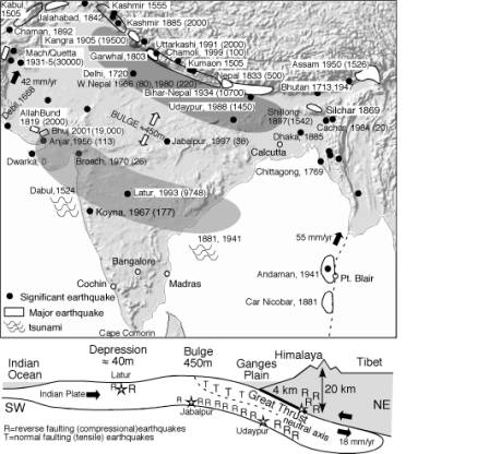
Figure
1. Schematic views of Indian tectonics.
Plate boundary velocities are indicated in mm/year. Shading indicates flexure of India: a 4 km deep trough near
the Himalaya and an inferred minor (40 m) trough in south central India are
separated by a bulge that rises approximately 450 m. Tibet is not a tectonic plate: it extends east-west and
converges north-south at approximately 12 mm/year. At the crest of the flexural bulge the surface of the Indian
plate is in tension and its base is in compression. Locations and dates of
important earthquakes mentioned in the text are shown, with numbers of
fatalities in parenthesis where known. With the exception of the Car Nicobar
1881, Assam 1897 and Bhuj 2001 events, none of the rupture zones major
earthquakes are known with any certainty.
The estimated rupture zones of pre-1800 great earthquakes are shown as
unfilled outlines, whereas more recent events are filled white.
The presence of both
flexural stresses and plate-boundary slip permits all mechanisms of earthquakes
to occur beneath the Lesser Himalaya (Figure 1). At depths of 4-18 km great
thrust earthquakes with shallow northerly dip occur infrequently that permit
the northward descent of the Indian Plate beneath the subcontinent. Earthquakes
in the Indian Plate beneath these thrust events range from tensile just below
the plate interface, to compressional and strike-slip at depths of 30-50 km
(e.g. M=6.6 20 August Udaypur, 1988).
A belt of
microearthquakes and moderate earthquakes beneath the Greater Himalaya on the
southern edge of Tibet indicates a transition from stick-slip faulting to
probable aseismic creep at around 18 km.
This belt of microseismicity defines a small circle with radius 1695 km
(Seeber and Gornitz, 1983; Bendick and Bilham, 2000). Seismicity in Tibet is largely shallow and is either normal
faulting or strike-slip faulting.
The flexural geometry
of the Indian Plate is manifest as a standing wave fixed relative to southern
Tibet. Stresses in the plate vary
slowly with time because the Indian plate streams slowly though this flexural
wave, bringing points within India towards or away from compressional or
tensile failure. It is for this reason that the earthquakes that occur
throughout central and northern India appear to have no distinctive spatial
pattern. The flexural stresses are significantly larger than the in-plane
stresses needed to sustain the elevation of the Tibetan Plateau, but their
change with time is slow (mbar/year).
Despite this their spatial
change is large (up to 2 bars per km northeastward (Bilham et al., 2003)) and
this results in an important imposed south-north spatial variation in
stresss. Stress changes of less
than 1 bar are known to trigger earthquakes. Although stresses throughout most of NE India are everywhere
close to failure, the triggering of earthquakes occurs partly from the movement
of India through the flexural stress field, and partly from local stress
perturbations caused by other tectonic, erosional or dynamic processes.
Historic Data
Sources and Catalogues
Early earthquakes
described in mythical terms include extracts in the Mahabharata (≈1500 BC)
during the Kurukshetra battle (Iyengar, 1994), and several semi-religious texts
that mention a probable Himalayan earthquake reputed to have occurred during
the time of enlightment of Buddha c. 538 BC.
Archeological
excavations in Sindh and Gujerat suggest earthquake damage to now abandoned
Harrappan cities. A probable earthquake around 0 AD near the historically
important city of Dwarka is recorded as a zone of liquefaction in archeological
excavations of the ancient city (Rajendran et al, 2002). The town of Debal (Dewal, Debil, Diul
Sind or Sindi) near the current site of Karachi was alleged to have been
destroyed in 893 AD (Oldham 1883), but until recently accounts of its collapse
and inundation were considered too vague to be taken seriously. Rajendran and Rajendran (2003) present
a case that the destruction of Debil was caused by an earthquake linked to the
same fault system responsible for the 1819 and 2001 Rann of Kachchh earthquakes,
however, Ambraseys (2003) notes that the sources of Oldham's account probably
refer to Daibul (Dvin) in Armenia, and that liquefaction 1100 years ago must be
attributed to a different earthquake.
Figure 2 shows the location of Debil west of the Indus delta in a 1690
map drafted by A. D. Winter. Other maps place it within the distributaries of
the Indus. Yule et al. (1903) describe Debil's 1000-year-long history, prior to
its effective disappearance from accounts within a century of a second
earthquake in its vicinity in 1668 (Oldham, 1883).
A single paragraph
describes a massive earthquake in the Kathmandu Valley in 1255 (Wright, 1877)
which may have been a great earthquake because it is alleged to have been
followed by three years of aftershocks, but the absence of reports from other
locations renders this of little value in estimating its rupture dimensions or
magnitude. Similarly the arrival of Vasco de Gama's fleet in 1524 coincided
with a violent sea-quake and tsunami that caused alarm at Dabul (Bendick and
Bilham, 1999). Note that this Portuguese port at latitude 17°34' on the Malabar
Coast is unrelated to Debil above.
This could have been a local event, but since it was not reported
onshore it could have been the tsunami from a remote earthquake that occurred
along the Makran or Gujarat coastlines. Such accounts are of thus of fragmentary value in quantifying earthquake locations
and sizes.
The emergence and
disappearance of coastal tracts has sometimes been ascribed to
earthquakes. A storm near Cochin
in 1341 caused an island to emerge, but inspection suggests this to be a common
accretional feature of storms along the Malabar Coast (Bendick and Bilham,
1999). An island that sank in 1769 south of Chittagong (Oldham, 1883) may have
undergone lateral spreading at the time of significant earthquake near there
(Seeber, personal communication 2003).
In the mid 19th
century some of these fragmentary data were collected successively in summaries
of earthquakes by Mallett, Baird-Smith and Oldham, but there followed more than
a century of archival neglect when little new information surfaced. The
seismicity of the sub-continent has been summarized in compilations by Chandra
(1977), Srivastava and Ramachandram, 1985, Rao et al. (1984) and by Khattri, (1992). Recent interest in early earthquakes
have engaged historians in India and elsewhere in a systematic search through
Urdu, Arabic, Tibetan, Chinese, Nepalese and European languages. Two important publications summarize
recent findings: Iyengar and Sharma (1998) report accounts in Arabic, Sanskrit
and Urdu sources and Ambraseys & Jackson (2003) provide new data from Tibet
and recently collated colonial records. Data presented in these publications
remain sparse but provide a skeletal framework of events on which to build a
future quantitative assessment of historic Indian earthquakes as new documents
surface. A list of Indian
earthquakes is to be found in Bapat et al. (1983) but this contains numerous
entries that have been included uncritically from secondary sources, and for
these reasons can be misleading.
Similarly, entries in the uncritical listing of Dunbar et al., (1992)
require careful evaluation before use. A useful and easily accessible
compilation of information and resources for the study of Indian earthquakes is
a web page maintained by Stacey Martin,
http://asc-india.org/menu/gquakes.htm. Relocated instrumental earthquakes are listed by Engdhal
et al., (1998).
An important recent
realization is that a sequence of significant earthquakes occurred throughout
the west Himalaya in the 16th century. The sequence started in Kashmir in 1501, followed by
two events a month apart in Afghanistan and the central Himalaya, concluding
with a large earthquake in Kashmir in 1555. The central Himalayan 1505
earthquake may have been Mw≥8.2 based on its probable rupture area. It destroyed monasteries along a 500 km
segment of southern Tibet, in addition to demolishing structures in Agra and other
towns in northern India (Jackson, 2002; Ambraseys and Jackson, 2003, Bilham and
Ambraseys, 2004).
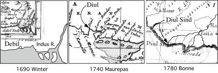
Figure 2. Maps in 1690 and 1740 show Debil
near the current location of Karachi.
Other maps show it on a distributary of the Indus. An earthquake
occurred there in 1668 and another is alleged by Thomas Oldham (1883) to have
occurred in 893 but the event he invokes occurred in an Armenian town with a
similar name (Ambraseys, 2004).
The city is last mentioned in the 18th century (Yule et al.,1903).
A Himalayan earthquake
that damaged the Kathmandu Valley in 1668 is mentioned briefly (a single
sentence) in Nepalese histories but as with events in 1255 and 1408 no details
are given (Chitrakar and Pandey, 1986). Earthquakes in the 18th
century are poorly documented. An
earthquake near Delhi in 1720 caused damage and apparent liquefaction but
little else is known of this event
(Kahn 1874; Oldham 1883).
This event, from its location, could have been a normal faulting event,
but because of the absence of damage accounts from the Himalaya it may have been
a Himalayan earthquake. In 1713 a
severe earthquake damaged Bhutan and parts of Assam (Ambraseys and Jackson, 2003).
Thirteen years later,
in September 1737, a catastrophic earthquake is alleged to have occurred in
Calcutta. This is the most devastating
earthquake to be listed in many catalogues of Indian (and global earthquakes)
but is actually a storm surge that resulted in numerous deaths by drowning
along the northern coast of the Bay of Bengal. The hand-written ledgers of the East India Company in Bengal
detail storm and flood damage to shipping, wharves, warehouses and dwellings in
Calcutta with an estimate of 3000 deaths by drowning (Bilham, 1994). Calcutta’s
population at the time was approximately 30,000. A figure of 300,000 fatalities is often ascribed to this
"fake-quake" for which earthquake shaking was probably invoked in
news reports as a metaphor for destruction, a possible description of the
buffeting accompanying extreme wind velocities. The spire of St. Annes church, Calcutta, was blown down by
these winds, but the masonry church survived. An approximate 10% increase in burials is recorded in its
churchyard for 1737, an increase in deaths that year by fewer than two dozen. Although the death-toll from drowning
along the coast of southern Bengal was presumably greater than the official
estimates in Calcutta, the fatality-count of 300,000 is repeated only in
accounts published in monthly magazines and newspapers in Europe, and is not
substantiated by official documents from any of the several administrative centers then functioning in
Bengal.
India in the early 19th
century was as yet incompletely dominated by a British colonial
administration. Remote
administrators in distant parts of the India subscribed to newspapers and wrote
verbose and sometimes extensive descriptions of their experiences which were
typically printed and circulated to each administrative outpost. An earthquake
in India was something of a rarity and generated detailed letters from
residents describing its effects.
Very often the same report would be copied verbatim from one newspaper
and reported by another. Few of
the original letters have survived, but the earthquakes in Kumaon in 1803,
Nepal in 1833 and Afghanistan in 1842 were felt sufficiently widely to lead
scientifically inclined officials
to take a special interest in the physics and geography of earthquakes.
Mallett's 1852-55 global catalogues of earthquakes included several from India,
with a special section devoted to the 1833 earthquake for which he discussed
seismic propagation velocities.
At about the time of
the sequential publication of Mallet’s global catalogue an army officer named
Baird-Smith wrote a sequence of articles 1843-1844 in the Asiatic Society of
Bengal summarizing data from several Indian earthquakes and venturing to offer
explanations for their occurrence.
He was writing shortly after the first Afghan war which had coincided
with a major 1842 earthquake in the Kunar Valley of NE Afghanistan (Ambraseys
and Bilham, 2003b), which must have impressed him and others in the military
service who were in NW India at the time.
Baird-Smith's accounts of other earthquakes include citations from his
sources.

Figure 3 Oldham,
father and son, were both geologists in India. Thomas Oldham (left) compiled
the first catalogue of Indian earthquakes. Richard (right) made definitive
studies of individual earthquakes (1819, 1869, 1881 & 1897) in addition to
identifying for the first time p- waves and s-waves, and the core of the earth.
The director of the
Geological Survey of India, Thomas Oldham
(1816-1878) published the first real catalog of significant Indian
events in 1883. His catalog
includes earthquakes from 893 to 1869, and acknowledges the works of Mallet and
Baird-Smith. His important
additions include verbatim textual extracts with references that permit
verification and further work. His
notes on some of the earthquakes form the first case detailed studies of
individual earthquakes.
His son, Richard. D.
Oldham (1858-1936), wrote accounts of four major Indian earthquakes (1819,
1869, 1881, and 1897). He
completed first his father’s manuscript on the 1869 Silchar, Cachar, Assam
earthquake which was published under his father's name (Oldham, 1884). He next investigated the Mw=7.9 December
1881 earthquake in the Andaman Islands, visiting and mapping the geology of
some of the islands (Oldham, 1884, 1885).
He mistakenly located the event deep in the northern Bay of Bengal based
largely on timing data from clocks in Calcutta and Madras. An analysis of the tsunami generated by
this earthquake places it on the subduction zone west of Car Nicobar (Ortiz and
Bilham, 2003). His account of the 1897 Mw=8.1 Shillong Plateau earthquake in
Assam (Oldham 1899) was exemplary, and according to Richter provided the best
available scientific analyses of available physical data on any earthquake at
the time. In contrast to the care with which he investigated the geological,
geodetic and geophysical aspects of the earthquake, Oldham's reports are thin
on specific accounts of building damage which he felt were often
exaggerated. Despite the
care with which he interpreted the intensity data available to him, his estimated intensities for the 1897
earthquake on a modified version of the Rossi-Forel scale are 1.5 to 3
intensity units too high in the epicentral region (Ambraseys and Bilham,
2003c).
R.D. Oldham’s accounts
established a template for the study of earthquakes that occurred in India
subsequently. The great
earthquakes of 1905 Kangra (Middlemiss, 1910) and 1934 Bihar/Nepal (Dunn et
al., 1939) were each assigned to Geological Survey of India special volumes,
but these never quite matched the insightful observations of Oldham’s 1899
volume. Investigations of the yet larger Assam earthquake of 1950 were
published as a compilation undertaken by separate investigators (e.g. Poddar,
1952; Ray 1952 and Tandon, 1952).
In many ways this proved to be the least conclusive of the studies of
the 5 largest Indian earthquakes 1819-1950. Information available to Indian
authors on the effects of the earthquake were confined largely to a narrow
corridor of information along the Brahmaputra valley since access to Tibet,
Burma, or the tribal regions south of the epicenter was unavailable.
Regrettably geologists did not make a thorough search for surface faulting in
the epicentral region and geodesy near the epicenter was virtually
non-existent.
Uncertainties associated with the 6 June 1819 Allah Bund
earthquake
Oldham wrote his
account of the 1819 earthquake in Kachchh in retirement in England (Oldham,
1928). His monograph synthesized
all the data available for the Allah Bund earthquake on the northern edge of
the Rann of Kachchh close to what is now the India/Pakistan border. The earthquake figures prominantly in
Lyell's Principles of Geology (1830) as one of the first clear examples of
geological uplift associated with an earthquake.
Oldham's 1928 account
refers to, but does not reproduce, Baker's map and profile from a leveling
survey crossing the Allah Bund. This profile is key to quantifying the
mechanism of the earthquake, and it is entirely due to its serendipidous
discovery by Oldham (1898) that we have access to it. The map had been
accidently omitted in Baker's original 1946 publication by the editor. In a frontispiece to the
Geographical Society of Bombay in 1846 he apologizes for omitting the map and
cross-section and promises to include the figure in subsequent issues, a
promise that he failed to fulfill.
Oldham had discovered the map quite by accident when supervising a
clean-up of the Bombay office of the Survey of India. In his discussion of the cause of the 1819 Allah Bund
earthquake Oldham speculates that the morphology across the natural dam measured
by Baker in 1846 was caused by subsurface faulting akin to that reported from
Japanese earthquakes in the early
20th century.
Assuming the surface
morphology to be representative of co-seismic deformation during a single
earthquake, Baker's 6 m crest-to-trough observation is consistent with 11 m of
slip on a north-dipping reverse fault terminating 0.5-2 km below the surface
(Bilham, 1999). However, recent
geological studies in the region (Rajendran and Rajendran, 2002) have raised
the possibility that the observed morphology was a factor of two smaller than
that reported by Baker, and that its current elevation of <3 m crest-to-base
is caused partly by the 1819 event and partly by pre-1819 earthquakes. A difficulty in rejecting Baker's
survey, a canal engineer of repute, is that he would have made vertical errors
of less than a few cm in measuring topography over the 10 km width of the Allah
Bund. Thus an error of 2-3 m can
be rejected. The cross-section
that was intended to accompany Baker's account was drafted from a larger scale
survey deposited with the Sind government. The smaller version published by Oldham included a
typographical error in the vertical scale, but it is unlikely that gross
drafting errors would have been introduced. Moreover, the accompanying map view of the river system is
exact in many details compared to recent satellite photos suggesting that its
execution was fastidious .
Several
explanations can be invoked to
reconcile the leveling data and current morphology. The first is that the
uplift and subsidence morphology may have changed since the earthquake. For
example, it is possible that Baker's measurements started at a lower vertical
datum than that available to the Rajendrans in 2000. According to Burnes (1833) the footwall subsided by
1-3 m, with maximum subsidence near the scarp. Burnes’s two handwritten
accounts in the Geological Society of London describe slightly different views
of the river cut through the Allah Bund in 1827 and 1828 that suggest it was
evolving in response to the flood of 1826. Currently the sediments of Lake Sindri slope upwards towards
the southern edge of the Allah Bund. In the past 180 years sediments eroded
from the front of the scarp, supplemented by sediments from the Narra River in
flood, would have filled any depression fronting the scarp along the northern
shore of Lake Sindri resulting in a datum possibly 2 m higher than that
available to Baker. The Rajendrans were unable to map vertical profiles
northward into the Sindh province of Pakistan hence it may not have been possible
to recover Baker’s northern datum.
A second possibility
is to assume that the southern edge of the Allah Bund has now been eroded 1 km
or more northward by monsoon winds and floods driving waves across the 30-50 km
wide fetch of open water to its south. In 1827 the crest of the scarp was fewer
than 600 m from its southern edge.
Ablation of the crest of the Allah Bund may have also occurred although
this is considered unlikely because Rajendran and Rajendran report the survival
of surface geodetic monuments installed in 1860.
The subsidence
deformation profile, now buried beneath Lake Sindri, may in fact be better
preserved than the uplift profile, and this, at some future date, may provide
additional constraints of slip in the 1819 earthquake. The depth of frontal
fill and co-seismic slip could be tested with suitable excavations, or seismic
profiles, of the northern edge of the bed of Lake Sindri.
While excavations of
Sindri sedimentation might clarify the discrepancy between historic leveling
and current morphology, the observation by Rajendran & Rajendran that two
or more earthquakes caused incremental changes in the height of the Allah Bund
requires downward revision of the 11 m estimate of coseismic slip to a more
modest 5 m. Any further reduction in the coseismic uplift of the Allah Bund can
be rejected based on Baker's mapping of the elevation of the bed of the Narra
River since this would have been at river base-level before the earthquake,
unaffected by previous earthquakes.
The recent Bhuj
earthquake 26 January 2001 earthquake was associated with 3-6 m of slip
(Bendick et al., 2001). Since this occurred on a 40 km x 40 km rupture, and
resulted in isoseismal intensity distributions throughout India similar to the
1819 earthquake (Hough et al.,
2002), it is tempting to assume that the two events had similar stress drops
and local attenuation relationships, and somewhat similar geometry and
magnitude. This would require the along-strike length of the Allah Bund
earthquake to be shortened considerably below the >100 km length first
suggested by Oldham and adopted by all later authors. In contrast, Ambraseys
and Douglas (2004) favor a Mw=8.19 magnitude for this event, requiring rupture
dimensions consistent with those inferred by Oldham (1928).
Himalayan Earthquakes 1 Sept 1803 and 26 August 1833
These earthquakes
occurred at the western and eastern ends of the inferred 6 June 1505
earthquake. The first of these
events occurred during the opening battles of the 2nd war against
the Mahrattas. In late August 1803
a British Army had laid seige to the fort and town of Aligarh on the banks of
the Calini River (between the Ganges and Jumna) some 200 km from the Himalaya.
The commander of the British Army, Lt. General Lake, writing to Wellesley on 1
September indicates that the strength of the defences will require a one month
seige. Yet, not three days later
Lake writes again to Wellesley that they have successfully stormed the town
with minor loss of life. In
contrast to Lake's silence on the earthquake that occurred between the two
letters, a member (Thorn, 1818) of the besieging army describes violent shaking
for 2 minutes at midnight accompanied by the collapse of several
buildings. The earthquake appears
in part responsible for the successful capture of the fort, either from damage
to its walls or distress to inhabitants, although specific details are lacking.
A
summary of materials available for the 1803 event is recorded by Ambraseys and
Jackson (2003) who assign it an approximate magnitude of Ms=7.5. This was later
revised to Mw=8.09 by Ambraseys and Douglas (2004) using additional materials,
who place it at the western end of the 1505 rupture. The 1833 earthquake almost
exactly 30 years later occurred at the eastern end of the 1505 rupture. In contrast to the extensive damage
reported from Tibet in 1505, few accounts of damage have surfaced from Tibetan
sources for these two earthquakes, suggesting that they were significantly less
severe than the 1505 event. The one exception to the apparent silence from
Tibet for the 1833 earthquake are accounts of damage from members of the Nepal
quinquennial tribute delegation returning from Beijing, who brought with them
accounts of the increasing damage they encountered as they approached the
northern Nepal border (Bilham, 1995).
The Ms≈7.7 August 1833
earthquake near Kathmandu consisted of three shocks (Bilham, 1995). The first caused alarm and the second,
5 hours later, brought most people from their homes. The mainshock (Mw=7.69, Ambraseys and Douglas, 2004)
occurred 15 minutes later causing widespread structural damage in India and
Nepal, but the combined loss of life in India and Nepal was only 500 because
most people were already in the open, alarmed by the two foreshocks. Newspaper reports of these events are
abundant as are scientific commentaries in journals in India and Europe. The isoseismals from this earthquake
suggest an epicentral region similar to, or at the western end of, the 1934
Ms=8.1 rupture, which together with the multiple shocks in the event, raises a
number of interpretational difficulties.
The earthquake did not affect western Nepal and its magnitude is too
small to have had much effect on releasing strain accumulated since the 1505
earthquake. However, had it occurred
on the plate boundary "detachment fault" it could not have released
much of the slip available to drive the larger magnitude 1934 earthquake a
century later. Since the 1934
earthquake is believed to have released up to 8 m of slip, and since potential
plate-boundary slip is renewed at a rate of less than 2 m per century, the 1833
rupture would have had to occur on different fault systems or to have slipped
on a small patch contiguous to the 1934 rupture. One possibility is that one or more of the three 1833
earthquakes occurred deep in the Indian plate where both strike-slip and thrust
faulting can occur, or that all three earthquakes were M≥7.5 thrust earthquakes
at the northern edge of the 1934 rupture zone, similar to those that have
occurred in the past several decades in western Nepal.
Cachar 10 January 1869
This M>7 earthquake
occurred in the Sylhet region (Silchar) of what is now NE Bangladesh. Although numerous accounts of this
earthquake were compiled by the Oldhams the data are insufficient to estimate a
causal fault or a precise magnitude Ambraseys and Douglass estimate
Mw=7.39. The most likely
fault to be associated with this earthquake is the eastern extremity of the
Dauki fault, as hinted by Godwin-Austin (1869) who was undertaking first-order
triangulation in the region at the time.
Few first hand accounts of the event exist outside the covers of Oldham
(1884) but the occasional letter describing its effects surfaces. An example is reproduced below:
“The
earthquake has not been a single shock but has lasted, on and off, a month- nay
it is said some of the shocks have gone on rocking for five minutes by the
watch till some people were literally sea sick. The bazaar at Silchar (the capital of Cachar) is the
handsomest street anywhere east of Calcutta and it has been engulfed. i.e. it
has gone bodily down not at once but in a series of descents, some ten feet at
a time. The river in Silchar in
the cold weather runs about 50 feet below the level of its banks which are only
dried mud, and the country has been so rocked up and down till the river has
cut its banks right down to its own level and the plain at Silchar is all one
debris with no particular river anywhere.
The commissioner told me on Monday last that it was officially reported
that the only thing left standing at Silchar was Clarke’s bridge, and it was the
most wonderful sight that ever was seen.”
(Clarke, 1869).
The dangers of
speculating on a causal fault or mechanism for the 1869 earthquake are
highlighted by radical errors of a century of interpretations of the 1897
earthquake that were shown to be baseless once the geodetic signal was assessed
in 2001. It is possible that enough of the 1869 geodetic survey network was in
place prior to the earthquake to render its remeasurement even now of value.
The 31 Dec 1881 Mw=7.9 Car Nicobar earthquake
This earthquake caused
minor damage in the Andaman Island Penal colony and generated a tsunami that
was observed throughout the Bay of Bengal but not along the Burmese coast. The
tsunami did no damage around the Bay of Bengal where tide gauges recorded a
maximum amplitude of 0.8 m (Oldham, 1884). An analysis of five tide gauge records reveals that the
earthquake was Mw=7.9±0.2 and occurred on an east-dipping thrust fault below
and to the west of Car Nicobar, an island at 9°N midway between the Andaman and
Nicobar islands (Ortiz and Bilham, 2003). GPS measurements at Port Blair
indicate oblique convergence of the plate boundary (Paul et al. 2001). The earthquake is believed to have
occurred on the interface between the Indian and Andaman Plates and the
inferred mechanism of westward slip of the hanging wall slip is consistent with
slip partitioning between the dipping subduction zone, and the strike-slip West
Andaman fault east of Car Nicobar.
A feature of this
earthquake is the inferred presence of a region of minor slip NE of the main
rupture zone. This may have been a
secondary earthquake triggered by the mainshock. Its timing would have to have occurred within a few minutes
of the mainshock for it to have produced the sea wave observed at Port Blair. Local populations were concentrated in
only two islands and therefore there is no corroboration of this inferred
northern region of submarine faulting which occurred between them. It is probable that offshore corals may
be of use in reconstructing an extended history of earthquakes in the
Andaman-Nicobar islands. The
island of Car Nicobar is believed to have been raised and tilted during the
1881 event. Deformation models
that do not include this uplift result in an inappropriate estimate of the
observed tsunami run-up on the island (Ortiz and Bilham, 2003).
1897 Shillong Plateau Earthquake
The 1897 Great Assam
earthquake (Ms=8.0) for more than a century was believed to have occurred on a
thrust fault dipping gently to the north. Some considered it to have been a
Himalayan basal thrust. We now recognize that the earthquake occurred on a
reverse fault dipping steeply to the south. Slip during the 1897 earthquake may
have exceeded 16 m, resulting in 10 m uplift of the northern edge of the
Plateau.
Oldham clearly
recognized the value of surface deformation as a quantitative measure of what
happens in an earthquake, but the analytical tools to interpret these data were
not to emerge for a further half century. In 1897 correspondence with the
Surveyor general, Sydney Burrard, Oldham requested a geodetic re-survey of the
Shillong Plateau. The work undertaken by J. Bond covered only the southern half
of the plateau and was considered by Burrard (1898) to be inferior in accuracy
to normal survey standards because numerous triangles did not close precisely.
(A test of survey accuracy is whether angles in a triangle after correcting for
spherical excess add up to 180°).
We now know that these misclosures were probably due to postseismic
adjustments in the epicentral region continuing after the earthquake. The 1897 displacement results
available to Oldham were ambiguous: either the plateau had bodily expanded and
risen with no southward motion, or it had risen without strain and moved
southwards by slip on the Dauki fault bordering its southern edge. Realizing this, Oldham urged resurvey
of the northern half of the plateau but he was destined never to see the data
since it was completed in 1936, the year he died (Davidson, 1936). Analyses of angle changes between 1869
and 1936 reveal that Oldham's instincts were correct. The fault that slipped in 1897 was a 110-km-long blind
reverse fault beneath the northern edge of the plateau, dipping southward at
45° with 16±5 m of slip between 9 and 39 km (Bilham and England, 2001). We
named this unmapped fault the Oldham Fault in his honour.
The earthquake raised
the northern edge of the plateau roughly 10 m. The causal fault is believed to have cut right through the
lower crust but did not approach closer than 9 km to the Earth's surface.
Oldham (1899) photographed secondary faulting of up to 10 m at the western end
of the Plateau on the Chedrang fault. The 1.6 km mean-height of the plateau
surface appears to have been driven to its current position by reverse faults
acting on both its northern and southern edges. Three dissected terraces border the northern edge of the
plateau that may be separated by active faults, but none have been mapped by
geologists possibly due to the thick forest cover that makes access difficult.
Enigmatic aspects of this earthquake concern the uniqueness of the Shillong
Plateau which permits contraction of the Indian plate within 80 km of the
Himalaya convergence zone, thereby reducing the productivity of Himalayan
earthquakes. An uplift rate of 2.5±1
mm/year can be calculated from the current elevation of the plateau, and from
the date of its initial elevation estimated from changes in sedimentation
styles in northern Bangladesh.
This convergence requires a convergence rate of 4±2 mm/year, or approximately
a factor 4 less than the India/Tibet convergence rate (Bilham and England,
2001). The only large historic earthquake known in the Bhutan Himalaya is the
1713 event described in Ambraseys and Jackson (2003c) and the precise location
of this event is far from certain.
The southern edge of the Shillong Plateau is truncated by the Dhauki fault. In
order that the surface of the Plateau be horizontal the Dhauki fault must also
act as a reverse fault, and this raises additional concerns. No historical earthquakes have been
recorded on this fault, and many previous studies interpret the fault as a
dextral strike-slip fault.
Although the fault may have slipped differently in the past there is
little doubt that reverse slip is now the prevailing mechanism, and has been so
for the past one or two million years. Earthquakes beneath the plateau have thrust mechanisms
parallel to the strike of the Oldham fault at depths of more than 35 km. The 1869 Cachar earthquake described by
the Oldhams may have occurred at the eastern end of the Dhauki fault (Oldham,
1884; Godwin-Austin, 1869).
A recent review of
instrumental records of the 1897 earthquake reveals its teleseismically
derived magnitude to be Ms=8.0
(Ambraseys, 2001) effectively the same as its geodetic seismic moment of M=8.1
(Bilham and England, 2001). A re-evaluation of Oldham’s 1897 isoseismal
intensity data supplemented by additional data from newspapers, diaries, books
and government reports unavailable to Oldham, reveal significantly reduced
areas for contours of intensity >VIII isoseismals, but similar areas for
lower intensity shaking. The newly
evaluated intensities include data from Tibet and Bhutan (Ambraseys and Bilham,
2003c).
Kangra 1905 M=7.8 earthquake
Occurring just 7 years
after the 1897 Assam earthquake, the Kangra event found the geologists of India
eager to map the details of the event.
The earthquake had its oddities –in particular a prominent epicentral
region of Rossi-Forel shaking of intensity VIII to X near Kangra and Dharmsala
and an island of VIII shaking almost 250 km to the SE near Dehra Dun. This, and an artificially-inflated
estimate for magnitude (Richter rounded Gutenberg's calculated magnitude upward
from M=7.8 to M=8 (Ambraseys and Bilham, 2000)), led several investigators to
assume that rupture may have extended more than 350 km along strike.
Although geodetic
measurements existed along the probable southern edge of the rupture, no
remeasurements were made after the earthquake except near the remote region of
high accelerations near Dehra Dun. No horizontal deformation was detected and a
vertical deformation signal, though discussed by many subsequent investigators,
has recently been dismissed as an artifact of the leveling process (Bilham,
2001). Hence there is little
evidence to believe that its rupture exceeded 200 km. First-order triangulation prior to the earthquake is limited
to the southern edge of the inferred rupture zone and it appears not to have
been re-measured since its initial measurement in 1845. An interpretation of a GPS occupation
of some of these points in 2001 is currently underway. Intensities of this
event are re-evaluated by Ambraseys and Douglas (2004).
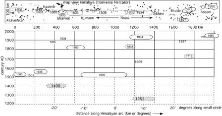
 Figure 4a
The Himalaya describe a small circle that subtends an arc of approximately one
radian symmetrically about the Thakola Graben in Tibet. Important mid-plate
earthquakes named. Microseismicity
follows this small circle (from Engdhal et al., 1992) and is negligible to its
south where great earthquakes are located. The arcuate box is expanded (and
straightened) in Figure 4b.
Figure 4a
The Himalaya describe a small circle that subtends an arc of approximately one
radian symmetrically about the Thakola Graben in Tibet. Important mid-plate
earthquakes named. Microseismicity
follows this small circle (from Engdhal et al., 1992) and is negligible to its
south where great earthquakes are located. The arcuate box is expanded (and
straightened) in Figure 4b.
Figure 4B shows time distance plot of approximate rupture areas of
large earthquakes in the past eight centuries plotted along the arc
(approximate transverse-Mercator projection of linear transverse-km vs angular
distance). One or more large earthquakes appear to be overdue in Kashmir, Kumaon and Western Nepal. We know of no earthquakes in Sikhim,
and the 1897 Assam Shillong earthquake may have reduced the slip potential in
Eastern Bhutan. Pre-1500 earthquakes are known with less certainty. Trench studies have revealed slip on
the frontal thrusts at the beginning of the fifteenth century at several
locations west of Dehra Dun (Senthil Kumar, personal communication, 2004) and
surface rupture on frontal thrusts in eastern Nepal may correspond to the earthquake
that destroyed Kathmandu in 1255 (Rockwell, personal communciation, 2004).
Discussion
The
above review of early earthquakes and case histories of some of the larger
earthquakes, omits numerous smaller ones felt by individuals or
communities. The larger ones form
a patchy history that may be complete for the past 200 years, but which is
certainly missing many large earthquakes before then. An important question is whether there is scant information
on pre-Muslim or medieval earthquakes because there were few events, or whether
it is because we have no records of them.
Although this question cannot be answered from the historic record alone
we may consider extreme scenarios as a guide to future searches to resolve the
issue.
Aggravating our lack of
knowledge of previous earthquake is the curious observation that none of the
numerous earthquakes that have occurred in India and the Himalaya in the past
several centuries have produced surface ruptures, with the exception of
secondary surface faulting in the 1897 earthquake (Oldham, 1898), and surface
fractures of the 1993 Latur earthquake (Seeber et al., 1993). In 1505 and 1892 surface faulting was
observed at the surface along the Pakistan/Afghanistan border (Ambraseys and Bilham, 2003a) but no
surface faulting has ever been reported in the Himalayan and Indo-Burman plate
boundaries, despite geological indications that surface rupture of the frontal
faults has occurred in the past (Wesnousky et al., 1999). The primary ruptures of the largest mid-plate events of the past
two centuries, the 7.8<M<8.1 1819 Allah Bund, the M=8.1 1897 Shillong,
the M=7.3 1931 Mach, and the M=7.6 2001 Bhuj earthquakes have all been on blind
thrust faults, dipping at approximately 45°, terminating 1-9 km below the surface,
and extending to the base of the crust.
Thus, although they have caused widespread destruction in the historical
record, the geological manifestation of their passage is limited to secondary
cracks and liquefaction phenomena that tell us little about their
mechanisms. Such knowledge about
rupture geometries as we have obtained for these earthquakes, with the
exception of the most recent, has been derived almost entirely from sparse
geodetic data.
The conclusion to be
derived from this absence of surface ruptures in the subcontinent is that many
historic earthquakes occurred on faults that are currently unmapped, and the
corollary is that there may exist many hundreds of subsurface faults
potentially awaiting re-activation for which we have no geological
intelligence.
The mechanisms of the
numerous smaller shocks that appear in historical Indian catalogues must be
inferred from modern focal mechanisms in those same geographic settings. The inherent problem in doing this is that
focal mechanisms in some parts of India, e.g. the Himalayan foothills, vary
with depth. Surviving intensity data are rarely adequate to distinguish between
deep and shallow shocks.
Intensity and attenuation
Estimates of
intensities for the two largest earthquakes of the past two centuries (1905 and
1897) have revealed that previous estimates of Rossi-Forel or Modified Mercalli
intensity tend to exaggerate high intensity shaking by 1-3 intensity units
(Ambraseys and Bilham, 2003c) whereas lower intensities (II-V) are estimated with
reasonable accuracy. The reason for this exaggeration is that the style of
building construction suffers significant damage at intensities around VII-VIII
and that subsequent shaking produces somewhat imperceptible additional damage
(Ambraseys and Bilham, 2003c).
Even quite recent intensity estimates can be suspect. For example, the 1989 Udaypur
earthquake in southern Nepal resulted in both Nepali (Pandey and Nicolas, 1989;
Dikshit and Koroila, 1989) and Indian (Sinha, 1993) intensity and engineering
damage studies. The resulting
intensity contours show an abrupt jump of 1-1.5 intensity units at the
Nepal/India border where the two studies abut.
The re-evaluation of
the felt intensity reports for the 1833, 1897, 1905, 1934 and 1950 earthquakes
on a common scale is an important priority that has been partly completed by
Ambraseys and Jackson (2004), since it may reveal the details of seismic
hazards in intervening regions where future Himalayan earthquakes are
anticipated. Currently more than three scales have been used to report these
data. Rossi-Forel, Modified
Mercalli and MSK intensities, with caveats imposed by their specific
inapplicability to Indian building methods. In some areas acceleration damage can only with difficulty
be distinguished from collapse caused by liquefaction-induced foundation
failure. In 1897 regions of extensive liquefaction and catastrophic lateral
spreading follow the banks of the main rivers and result in building damage
from foundation collapse, rather than grades of shaking intensity. Ambraseys
& Bilham (2003c) separated liquefaction observations from MSK assignations
based on shaking intensity lest they bias the areas of isoseismal
contours.
Himalayan
recurrence interval
The recurrence
interval for great Himalayan earthquakes remains conjectural since the historic
record is probably incomplete even for the past 500 years. A summary of those events for which we
have data is depicted in Figure 4,
although both the rupture area and the amount of slip are unknown for each of
these events. The figure suggests
that the western Himalaya may have slipped in a sequence of events between 1501
and 1555, and that since then there have been relatively modest earthquakes,
insufficient to release the 1.5-1.8 m per century of accumulating convergence
revealed from geodetic measurements.
The largest of the pre-1900 earthquakes, the 6 June 1505 Kumaon/western
Nepal earthquake (Jackson, 2002; Ambraseys and Jackson, 2003), may have
exceeded Mw=8.2, and its recurrence now would result in a similar-sized
earthquake (9 m of slip along a 500-600 km rupture zone). Damage in northern India was
considerable during the 1505 event and it is likely that its recurrence would
damage many of the large cities along the Ganges and Jumna rivers through shaking,
and from the effects of extensive liquefaction. Smaller seismic gaps are evident in Kashmir, in Sikkim and
in Assam for which the historic record is ambiguous or absent.
Assuming that 7-10
great ruptures permit the slip of the entire Himalayan Arc, and a recurrence
interval of 500 years (≈9 m slip on 200-300 km long,70-90 km wide, ruptures) we
should anticipate M≥8 earthquakes occurring every 50-70 years. Insufficient earthquakes have occurred
recently to match this estimate.
Two great earthquakes only that approach this severity have occurred in
the past 200 years (1934 and 1950), and two others are known in the previous
300 years (Kashmir, 1505 and 1555). No great earthquake has occurred for 53
years. Almost 2/3 of the Himalaya
remain unbroken by recent earthquakes, suggesting that several seismic gaps may
currently exist. Finally, the summation of seismic moment from all known
earthquakes since 1505 along the entire arc yields a slip rate less than 30% of
that derived from the current geodetic slip rate (Bilham and Ambraseys, 2004).
From these arguments
we may form one of two conclusions:
that one or more great Himalayan earthquakes are overdue, or that our
understanding of the way in which the northern plate boundary slips is flawed. The case for the imminent failure of a
seismic gap is hampered by the absence of any well documented recurrence interval, or indeed any
evidence for regular failure of the Himalayan plate boundary. The absence of constraint permits the
extreme view, for example, that failure occurs in clustered sequences, as may
have occurred in the western Himalaya 1400-1555. If indeed this sequence
released accumulated displacements in the western Himalaya five centuries ago,
then a case can be made for recurrence about now in one or more 9 m slip
events, based on the current convergence rate of 18 mm/year. The region of the
1505 earthquake has been hitherto termed the Central Himalayan seismic gap by Khattri
and Tyagi (1983) and Khattri
(1987).
Alternatively, the
assumption that great earthquakes are essential features for plate boundary
slip may be incorrect - the Himalaya may fail in smaller events that
incompletely rupture the plate boundary.
These smaller events might be considered to be similar to the ChiChi
earthquake of 1999 that ruptured through a mid-level segment of the
accretionary wedge, rather than through a basal detachment. Such events may
accommodate convergence without translating the entire Himalaya southward over
India. The major 1833, 1885 and
1905 earthquakes (7.5<Mw<7.8) may have been examples of these
“out-of-sequence thrusts”.
One of the most
troubling observations, that might be accounted for by out-of sequence
thrusting, is that no recent Himalayan earthquake has ever resulted in a
recorded surface rupture. Such ruptures have obviously occurred in recent
geological time, on the main frontal thrusts for example (Wesnousky et al.
1999), signifying either that
recent earthquakes are anomalously small, or that the search for surface
rupture may not have been exhaustive.
If some, but not all, great earthquakes rupture the Himalayan frontal
thrusts we cannot hope to quantify the recurrence interval from these events
using paleoseismic fault-trenching methods.
Out of sequence
thrusts cannot represent a steady-state condition for Himalayan slip since it
would not explain the geological observation of occasional slip on the basal
thrust systems and Main Frontal Thrusts.
However, it is possible that excessive recent erosion of the Himalayan
foothills may have upset the uniform taper of the Himalayan accretionary wedge
such that adjustments are now underway that result in a predominance of
high-level thrusting interspersed with infrequent basal thrusts.
Historical studies
have an important role in distinguishing between these various scenarios, yet
it is unlikely that we shall ever find a history that is complete across- and
along- the Himalaya, even near the Kathmandu and Kashmir Valleys that have been
administered continuously by a record-keeping population for the past thousand
years. For this reason, trench
investigations of faults and liquefaction features will be necessary to fill in
the record. Data from the In practice,
the subsurface record of strong-ground motion is complete, but its
interpretation may be non-unique, suitable conditions may not exist everywhere
for it to be recorded, and it is
insensitive to small earthquakes whose recurrence may be quite damaging.
Mid-plate recurrence intervals
Although numerous
micro-earthquakes, and many damaging shocks have occurred in the past several
centuries in India, the geodetic stability of the plate, and the absence of recent mountain
ranges indicates that earthquakes should not recur repeatedly on the same fault
during the written history of India.
Yet archeological observations in India suggest earthquakes may have
repeatedly destroyed early settlements there, especially in westernmost
India. Rajendran et al. (1996)
present evidence for reactivation of the fault causal to the Latur earthquake.
The town of Latur itself, like many Indian villages, is a mound city built on
the ruins of previous cities.
The occurrence of the
M=7.6 Bhuj 2001 earthquake less than two centuries after the M≈7.8 Allah Bund
1819 earthquake has been considered by some investigators to represent a short
recurrence interval for earthquakes in mid-plate India. The two earthquakes occurred on the
ancient Kachchh rift zone, an east-west fault system that be traced
structurally from near Karachi to Ahmedabad. In a study of the 1819 event it
was concluded that contiguous future faulting might be anticipated, with specific concern that rupture to
the west would create hazards for Karachi (Bilham, 1999). As it happened,
rupture in 2001 occurred 2-4 rupture lengths to the east of the 1819
earthquake. Hence there is a
possibility that the entire Kachchh rift may be converging. In fact geodetic data suggest that the
rift north of the Bhuj region may have converged by more than 1 m since 1856
(Sri Devi et al., 2003).
Should this be the case, additional large earthquakes may be anticipated
both to the east and west of the 1819 and 2001 earthquakes.
The observed geodetic
convergence of the Rann of Kachchh by 9±3 mm/year is approximately 2-3 times
larger that the entire geodetic convergence rate between northern and southern
India (Paul et al., 2000). Two
explanations for this have been proposed: one is that a 400-km-wide continental
“Sindh flake” is in the process of fracturing from the NE edge of the Indian
plate (Stein et al., 2002), the other is that the interconnected ancient rift
systems of northern India define a small northern plate “ the Harappan Plate”
that allows a large triangle in NE India between the central Himalaya and Bhuj
to converge with the main body of the Indian plate to the south (Bilham et al
2003). Support for either
mechanism of plate fragmentation is weak,
and future geodetic observations are needed to resolve the extent of
plate deformation in NE India.
Conclusions
The tectonic setting of India’s collision with Asia is now reasonably well
characterized from recent seismicity and geodetic studies of relative motion at
their plate boundaries.
Direct measurements across and within the Himalaya reveal a locking line
beneath the edge of the Tibetan Plateau and the absence of creep to its south
(Bilham et al, 1995; 1998; 2001), implying that the advance of the Himalaya
over the Indian plate proceeds largely through the recurrence of great plate
boundary earthquakes.
Earthquakes within the
Indian Plate are attributable to the superposition of the NW compressional
stress of collision, on the stresses arising from plate flexure. The depth and
mechanisms of recent earthquakes reflect the sense of these combined stresses.
A several
millennia-long written record in India has revealed few major earthquakes prior
to the past two centuries. This is
partly due to the fact that extant records have yet to be searched rigorously
for earthquakes, but is in part due to the corruption of potentially valuable
records and their loss through fire, war and decay. Despite their sparseness it is likely that documents on
historic earthquakes will surface in Tibetan, Urdu and Arabic records that will
change current estimates of the significance of seismic gaps in the Himalaya,
and may change our understanding of earthquakes within the Indian continent.
Our current
understanding of Himalayan earthquakes is such that we may calculate potential
slip in several segments of the plate boundary, but we cannot estimate the
timing of future events. Making
assumptions about the probable completeness of the historic seismic record we
can estimate relative seismic hazard,
or we can estimate minimum slip potential based on the time since the last
known earthquake (Bilham et al., 2001).
This has moderate relevance to planning for future earthquakes. The eventual establishment of
recurrence intervals for Himalayan ruptures will require a combination of
serendipitous historical studies and geological trench investigations of
faulting and earthquake-induced liquefaction features.
Acknowledgments
I thank R. S. Cox of
the American Philosophical Society for providing a copy of C. B. Clarke’s
letter concerning the Silchar earthquake. This study was funded by the National
Science Foundation EAR-0003449. I
thank the organizers of the Erice conference on historical earthquakes for
inviting my participation.
References
Ambraseys N. (2000)
Reappraisal of north Indian earthquakes at the turn of the 20th
century , Current Science, 79, 101-114
Ambraseys, N. N., (2004). A
note on three little-known early earthquakes in India, Current Science, in the press. Bangalore.
Ambraseys, N., and D. Jackson, (2003), A note on early
earthquakes in northern India and southern Tibet, Current Science, 84(4), 571-582.
Ambraseys, N., and R. Bilham, A note on the Kangra Ms=7.8
earthquake of 4 April 1905. Current Science, 79, 101-106, 2000.
Ambraseys, N., and R. Bilham (2003a) Earthquakes and crustal deformation in northern
Baluchistan, Bull. Seism Soc. Am. 93(4), 1573-1605,
2003
Ambraseys, N., and R. Bilham, (2003b). Earthquakes in
Afghanistan, Seism. Rev. Lett., 74(2), 107-123
Ambraseys, N., and R.
Bilham, (2003c). MSK Isoseismal intensities evaluated for the 1897 Great Assam
Earthquake., Bull. Seism Soc. Am. 93(2) 655-673,
2003
Ambraseys N. and J.
Douglas, (2004). Magnitude calibration of North Indian earthquakes, Geophys.
J. Int. in the press.
Baird-Smith R., (1843) Memoir on Indian earthquakes, Pt.1. J.
Asiat. Soc. Bengal, 11, 1046-1054, Calcutta.
Baird-Smith, R. (1843), Memoir
on Indian Earthquakes, Pt. II, J. Asiatic Soc. Bengal, 12(2), New Series, 136,
1029-1056.
Baird-Smith, R., (1844),
Memoir on Indian Earthquakes, Pt. III, J. Asiatic Soc. Bengal, 156, 964-983.
Baker, W. E., (1846). Remarks on the Allah Bund and on the drainage
of the Eastern part of the Sind Basin, Trans. Bombay Geog. Soc., 7, 186-188.
Bapat A., Kulkarni R., Guha S. (1983) Catalogue of
earthquakes in India and neighbourhood from historical period up to 1979, Indian
Soc. Earthq. Eng., Roorkee.
Bendick, R. and R. Bilham (1999) Search for buckling of the southwest Indian coast related to
Himalayan collision. In Himalaya and Tibet: mountain roots to mountain
tops. Ed. A. Macfarlane, R.
Sorkhabi, and J. Quade. Geological Society of America Special Paper 328. 313-323.
Bendick, R.,
R. Bilham, E. Fielding, V.
K. Gaur, S. Hough, G. Kier, M. N. Kulkarni, S. Martin, K. Mueller and M. Mukul, The January
26, 2001 "Republic Day" Earthquake, India. (2001) Seism. Res.
Lett., 72(3), 328-335.
Bendick, R., and R. Bilham, How
perfect is the Himalayan Arc? Geology, 29,791-794, 2001.
Bilham R. (1995) Location and magnitude of the 1833 Nepal
earthquake and its relation to the rupture zones of contiguous great Himalayan
earthquakes, Current Sci., 69, 101-128
Bilham R., Bodin P., Jackson M. (1995) Entertaining a great
earthquake in western Nepal; historic inactivity and geodetic tests for the
development of strain, Journ. Nepal Geolog. Soc., 11,73-88,
Kathmandu.
Bilham, R. (1994). The 1737 Calcutta Earthquake and Cyclone
Evaluated, Bull. Seism. Soc. Amer.
84(5), 1650-1657.
Bilham, R., K.
Larson, J. Freymueller and Project Idylhim members, (1997). GPS measurements of
present-day convergence across the Nepal Himalaya, Nature(Lond)., 386, 61-64 1997.
Bilham, R. (1999). Slip parameters for the Rann of Kachchh,
India, 16 June 1819, earthquake, quantified from contemporary accounts. In Stewart, I. S. &
Vita-Finzi, C. (Eds) Coastal Tectonics.
Geol. Soc. London, 146, 295-318.
Bilham, R., (2001) Slow tilt reversal of the Lesser Himalaya
between 1862 and 1992 at 78°E, and bounds to the southeast rupture of the 1905
Kangra earthquake, Geophys. J. Int. 144, 1-23.
Bilham. R., F.
Blume, R. Bendick and V. K. Gaur (1998) Geodetic constraints on the Translation
and Deformation of India: implications for future great Himalayan earthquakes, Current
Science, 74,(3), 213-229.
Bilham, R., R. Bendick and K. Wallace (2003). Flexure of the Indian Plate and Intraplate Earthquakes, Proc. Indian
Acad. Sci. (Earth Planet Sci.),112(3) 1-14.
Bilham, R., and N. Ambraseys,
(2004) Apparent
Himalayan slip deficit from the summation of seismic moments for
Himalayan earthquakes, 1500-2000, Current Science, in the press
Bilham, R., and V. K Gaur, (2000) Geodetic contributions to
the study of seismotectonics in India, Current Science 79(9), 1259-1269.
Bilham,
R., V. K. Gaur and P. Molnar, (2001) Himalayan Seismic Hazard, Science, 293, 1442-4.
Burnes, Lieut. A., (1833). A memoir
of the eastern Branch of the Indus giving an account of the alterations
produced in it by the earthquake of 1819 and the bursting of the dams in 1826;
also a theory of the Runn’s formation and some surmises in the route of
Alexander the Great” Presented by the Hon’ble the Governor in Council to the
Lit. Soc. of Bombay. Camp at Lucput , 28 March 1827, 13 August 1828.
Handwritten Manuuscript presented by the Author to the Geological Society of
London 18 December 1833. With map inscribed W. Ballantine 1831.
Chandra, U., 1992, Seismotectonics of Himalaya, in
Seismology in India, Current Science,
Indian Acad. Sciences, Bangalore. 62, 40-71.
Clarke, C. B. (1869), Letter to father. Manuscript American Philosophical
Society, Philadelphia.
Curray, J. R, F. J. Emmel, D. G. Moore, R. W. Raitt (1982).
Structure, tectonics and geological history of the NE Indian Ocean, in The
ocean Basins and Margins, edited by E. M.
Narrin and F. G. Sehli, 6, 399-450.
Curray, J.R., Emmel, F.J., Moore, D.G., Raitt, R.W., Henry,
M., and Kieckhefer, R., (1979). Tectonics of the Andaman sea and Burma, in
Geological and Geophysical Investigations of Continental margins, edited by J.S. Watkins, L. Montadert and P. Dickerson,
AAPG Memoir, 29, 189-198.
Davidson, C., (1936) R. D. Oldham: Obituary, Nature, 138, 316-317.
Dikshit, A.M. and A. Koirala, Report on the Intensity mapping
of Udaypur Earthquake of 20 August 1988. HMG Ministry of Industry, Nepal ,
Dept. of Mines and Geology, Lainchaur, Kathmandu May 1989
Dunbar, P.K., P. A.
Lockridge, & L. S. Whiteside,
1992, Catalog of significant earthquakes, including quantitative casualties
and damage; National Oceanic and Atmospheric Adminstration,
National Environment Satellite Data and Information Service, National Geophysical Data Center, Report SE-49, 320p.
Dunn, J. A., J. B. Auden, A. M. N. Gosh and S. C. Roy, 1939
(reprinted 1981), The Bihar-Nepal Earthquake of 1934, Mem. Geol. Soc. of
India, Survey of India, Calcutta. 73, pp.
391.
Engdahl, E. R. Van der Hilst, R.D., and
Buland, R.P., Global teleseismic earthquake relocation with improved travel
times and procedures for depth determination, Bull. Seism. Soc. Amer., 88, 722-743, 1998.
Godwin-Austin, (1869) Notes from Assaloo, North Cachar, on
the Great Earthquake of 10 January 1869,
Proc. Asiatic Soc. Bengal, 15 March 1869, 91-99.
Hough, S. E., S.
Martin, R. Bilham and G. Atkinson, The January 26 2001, Bhuj India earthquake:
Observed and predicted Ground Motions, Seism. Soc. Am. 92(6), 2061-2079, 2002.
Iyengar R.N., Sharma D. (1998) Earthquake history of India
in medieval times, Rep. Central Build. Res. Inst., 124pp,
Roorkee.
Iyengar, R. N., 1994, Earthquake History of South India, The
Hindu, Jan. 23.
Jackson D. (2002)
The great western-Himalayan earthquake of 1505: a rupture of the central
Himalayan gap?, in Tibet, Past and Present, ed. H. Blezer, pp.147-159, Brill's
Tibetan Studies Library I, Leiden
Khan, K., (1874).
Muntakhab-ul Lubab, M.H.,
Bibl. India Series, Calcutta.
Khattri, K. N, and A. K. Tyagi, 1983, Seismicity Patterns
in the Himalayan Plate Boundary and Identification of Areas of High Seismic
Potential, Tectonophysics, 96, 281-297.
Khattri, K. N., 1987, Great earthquakes, seismicity gaps
and potential for earthquake disaster along the Himalaya Plate boundary, Tectonophysics, 138, 79-92.
Lyell, C., (1830),
Principles of Geology, John Murray, London Mallet R. (1852) On the facts
of earthquake phenomena, Rep. Brit. Assn. Adv. Sci. for 1850, London
Mallet, R., (1852), Report of the Twenty-first meeting
of the British Association for the Advancement of Science, Ipswich, 1851, Second Report on the Facts of Earthquake Phenomena,
272-320
Mallet, R., (1855), Report of the Twenty-fourth meeting
of the British Association for the Advancement of Science, Liverpool, 1854, Catalogue of Recorded Earthquakes from 1606 B.C. to A. D.
1850 (continued from Report for 1853), 2-326.
Middlemiss, C. S., 1910, The Kangra Earthquake of 4 April
1905. Mem. Geol. Soc. of India, 38, pp.
409, Geol. Surv. India, Calcutta.
Oldham, T., (1883), A Catalogue of Indian
earthquakes, Mem. Geol. Surv. India, 19,
163-215, Geol. Surv. India, Calcutta.
Oldham, R. D. Note on the earthquake of 31 December 1881
(1884). Records of the Geological Survey of India, 17(2), 47-53.
Oldham, R. D., (1885). Geology of the Andaman Islands with
references to the Nicobars, Records
of the Geological Survey of India, 18(3),
135-145.
Oldham, R. D., (1898). A note on
the Allah Bund in the north west of the Runn of Cuch. Mem. Geol. Surv. of
India,
28,
27-30.
Oldham, R. D., (1899), Report on the Great Earthquake of 12
June 1897, Mem. Geol. Soc. of India, 29, pp. 379. Geol. Surv. India, Calcutta.
Oldham, R. D., (1928). The Cutch (Kacch) earthquake of 16.
June 1819 with a revision of the great earthquake of 12. June 1897, Mem. Geol.
Survey India, 46, 71-147.
Ortiz, M., and R.
Bilham, source area and rupture parameters of the 31 Dec. 1881 Mw =7.9 Car
Nicobar earthquake estimated from Tsunamis recorded in the Bay of Bengal
(2003), J. Geophys. Res., 2002JB001941RR 2003.
Pandey M. R. and M. Nicolas, (1989), The Aftershocks sequence of the
Indian-Nepalese earthquake of August 20, 1988. Dept. of Mines and Geology,
HMG Nepal, Report 2 March 1989.
Chitrakar G.
R. and M. R. Pandey (1986) Historical earthquakes of Nepal, Bull. Geol. Soc.
Nepal, 4, 7-8
Pandey, M. R. and P. Molnar, 1988, The
distribution of Intensity of the Bihar Nepal earthquake of 15 January 1934 and bounds on the extent of the
rupture, J. Nepal Geol. Soc, 5, 22-44.
Paul, J., Burgmann, R. Gaur, V. K. Bilham, R. Larson, K. M. Ananda, M. B. Jade,
S. Mukal, M. Anupama, T. S.
Satyal, G., Kumar, D. 2001 The motion and active deformation of India. Geophys.
Res. Lett. 28 (4) , 647-651,
2001.
Poddar, M. C. A short note on the Assam earthquake of Aug.
15, 1950, 38-42, in A compilation of
papers on the Assam Earthquake of August 15, 1950. ed. M. B. Ramachandra Rao,
Publication No. 1 CentralBoard of Geophysics, Gov. of India, 1953.
Rajendran, C.P., Rajendran, K., John, B. (1996): The
Killari (Latur), Central India, earthquake: an example of fault reactivation in
the Precambrian crust. Geology 24, 651-654.
Rajendran C. P, , K. Rajendran, K. H. Vora and A. S. Gaur,
(2003). The odds of a seismic source near Dwarka, NW Gujarat: An evaluation
based on proxies, Current Science, 84, 695-701.
Rajendran,C.P.,
(2000) Using geological data for earthquake studies: A perspective from peninsula India, Current
Science, 79(9), 1251-1258.
Rajendran, C.P., and Rajendran, K., (2001). Characteristics of Deformation and Past Seismicity Associated with the 1819 Kutch Earthquake, Northwestern India, Bull. Seism. Soc. Am., 91(3), 407-426.
Rajendran, C.P., and Rajendran, K., (2002) Historical Constraints on Previous Seismic Activity and Morphologic Changes near the Source Zone of the 1819 Rann of Kachchh Earthquake: Further Light on the Penultimate Event., Seism Res. Lett., 73(4), 470-479.
Rao, B. Ramalingeswara
and Rao, P. Sitapathi, 1984,
Historical seismicity of Peninsular
India: Bull.
Seism. Soc. Am., 74(6),
2519-2533.
Ray, 1953, Isoseismals for the great Assam Earthquake of
Aug. 15 1950, 35-37, in A compilation
of papers on the Assam Earthquake of August 15, 1950. ed. M. B. Ramachandra
Rao, Publication No. 1 Central Board of Geophysics, Gov. of India, 1953.
Seeber , L.,and V. Gornitz (1983), River profiles along the
Himalayan arc as indicators of active tectonics, Tectonophysics, 92, 335-367.
Seeber, L, G. Ekstrom, S.K. Jain, C.V.R. Murthy, N. Chandak
and J.G. Ambruster, (1996). The Killari earthquake in central India: A new
fault in Mesozoic basalt flows?, Jour. Geophys. Res., 101, B4, 8543-8560.
Sella , G. F., T. H. Dixon , and A. Mao, (2002). REVEL: A
model for recent plate velocities from space geodesy, J. Geophys. Res., 107, 10.1029/2000JB000033.
Sinha, K. K., 1993, Isoseismal Studies, 49-58, in Bihar-Nepal Earthquake Aug. 20 1988, Geol. Surv. of
India. Special Publication 31, pp. 104.
Sri Devi Jade and 12 other
authors, (2003), Pre-seismic, co-seismic and post seismic displacements
associated with the Bhuj earthquake derived from recent and historic geodetic
data. J. Ind Inst of Sci. 112(3), 331-346, 2003.
Srivastava, N. N. and K. Ramachandram, 1985, A new
catalogue of earthquakes for Peninsular India during 1839-1900, Mausam, 36(30), 351-358.
Sukhija, B. S., M. N. Rao, D. V.
Reddy, P. Nagabshanam, S. Hussain, R. K. Chadha and H. K. Gupta, (1999). Timing and return of
major paleoseismic events in the Shillong Plateau, India, Tectonophysics, 308, 53-65.
Stein, S., G. Sella, and E.A. Okal, The January 26, 2001 Bhuj earthquake
and the diffuse boundary of the Indian plate, Amer. Geophys. Un. Geodyn.
Monog., 30,
243-254,
2002.
Tandon, A. N., The Very Great Earthquake of Aug 15 1950,
80-89,in A compilation of papers on the
Assam Earthquake of August 15, 1950. ed. M. B. Ramachandra Rao, Publication No.
1 Central Board of Geophysics.
Thorn, W., (1818).
Memoir of the war in India conducted by General Lord lake and Major General Sir
Arthur Wellesley, Duke of Wellington, T. Egerton Military Library,
Whitehall, London. 93-94.
Wang, Qi, Pei-Zhen Zhang, J. T. Freymueller, R. Bilham, K. M.
Larson, Xi’an Lai, X. You, Z. Niu, J. Wu, Y. Li, J. Liu, Z. Yang, Q. Chen, Present Day Crustal
Deformation in China constrained by Global Positioning Measurements,
Science, 294, 574-577, 2001.
Wesnousky,
S. G. , S. Kumar, R. Mohindra, and V.C. Thakur, (1999) Holocene slip rate of the Himalaya Frontal Thrust of
India-Observations near Dehra Dun, Tectonophysics, 18, 967-976.
Wright,
D., (1877). History of Nepal. 1966 reprint: Calcutta, Ranjan Gupta,
271.
Yule,
H and A. C. Burnell (1903), Hobson-Jobson: A glossary of colloquial
Anglo-Indian words . New Delhi,
John Murray, pp. 1021, (1995
reprint p.320-321).