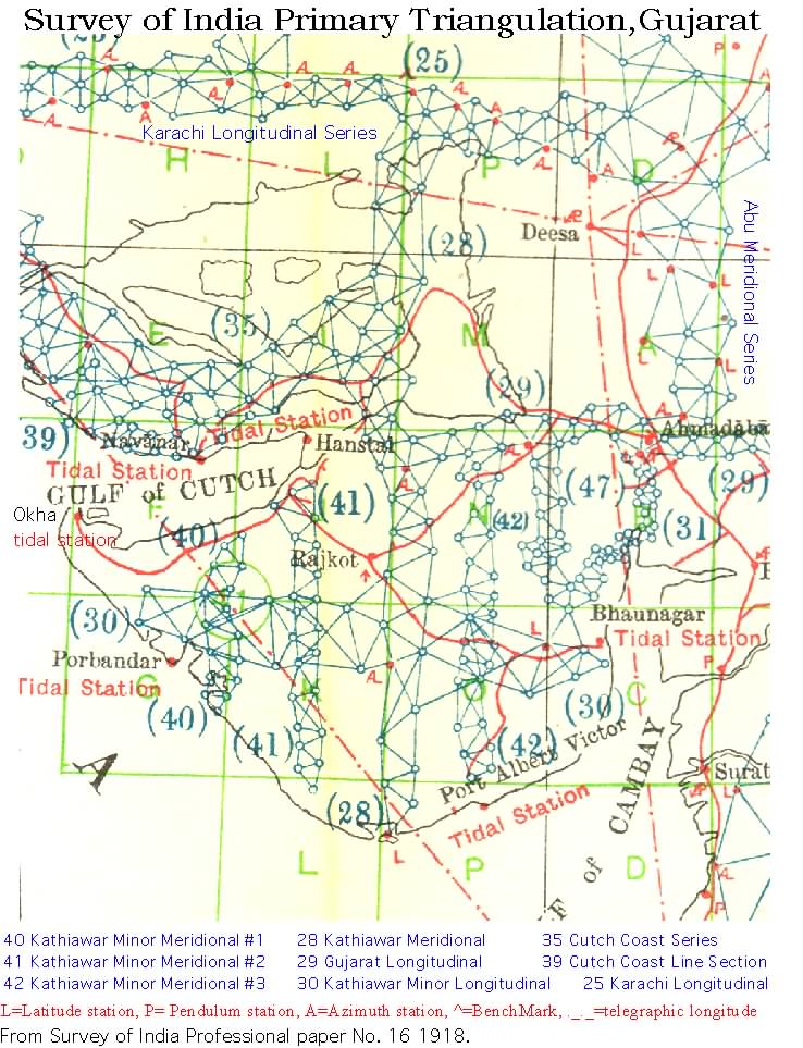
The following figure shows the rich network of primary and secondary series in the Gujarat region. The Figure is from deGraaff Hunter , 1918.
Site descriptions for Kachchh (Cutch Coast Series) and Kathiawar (Katywar meridional Series) are listed below, together with brief recovery information.
Cutch Coast Series
from Strahan, G., Synoptical Volume XXXIII of the Great Trigonometrical Survey of India, The Cutch Coast Series (or series L) of the South West Quadrilateral, Dehra Dun 1893.
Text in black is from 1872 site description with coordinates precise to one minute of arc.Text highlighted in blue were reoccupied using GPS methods after the earthquake ( longitudes are uncorrected for an easterly Madras longitude bias in 1872 listings. The correction for longitude is given in Strahan 1872 as approximately -2.5'.) Desciptions of status of points inspected or occupied after the 2001 earthquake are inserted in red.
Description of Principal Stations
The stations of this series numbered I to XXV, XXXVIII, XLII, XLIV, XLV as well as stations VII, XI, and XIV of the Kathiawar Meridional Series and CIV and CVII of the Karachi Longitudinal Series are situated on hills or rising ground, and consist of circular, isolated pillars of masonry either solid or perforated, 3 to 13 feet high, having a mark engraved on the rock in situ or on a stone embedded at about the ground level. The solid pillars have a mark at the summit and sometimes one or more other marks engraved on stones inserted in them in the normal of the lower mark. Round these pillars and level with their summits, platforms of earth and rubble, earth and wood, or other materials have been constructed for the observatory tent to rest on. At those stations where the pillars are perforated, access to the ground level mark is obtained through an aperture left for the purpose. At all the remaining stations situated in the plains, it was found necessary on account of the curvature of the earth to construct towers. These range from 20 to 27 feet in height, and are built in a similar manner to those already described which have perforated pillars.
The following descriptions have been compiled from those given by the officers who executed the series, from the records in the Levelling Operations in 1874-1875 and 1889-90, supplemented as regards adjacent villages and places from the Topographical Survey Maps (where available) of the country traversed and corrected, so far as the local sub-divisions in which the several stations are situated, from the latest annual reports furnished by the district officers to whose charge the stations are committed.
VII (Of the Kathiawar Meridional Series). Gangta Hill Station, lat. 23 44', long. 70 32' (23 44 5.53 70 32 22.49)- observed at in 1856 is situated on the highest part of a hill in the Ran of Cutch. The ruins of a tower and walls are to be seen here, the place having once been the stronghold of freebooters. The road from Rav to Gadhada across the Ran passes by the south-western foot of the hill about 7 miles N.W. of the village of Rav, and the same distance N. by W. of that of Jesada. It is in the lands of the village of Rav, pargana Vagad, Cutch State. The station consists of a platform, enclosing a solid, circular, and isolated pillar of masonry about 5 feet in height. This site was damaged by the 2001 earthquake resulting in the loss of the upper mark and severe damage to the rubble platform. The lower mark appears still in position at the base of the hollow central pillar whose edges are in reasonable state of repair and are vertical. The presence of a large scorpion (and possibly others) deterred exposure of the central mark which lay beyond arms length. The 15 cm x 15 cm rectangular opening was taken to define the mark's position to an accuracy of ±10 mm horizontally, and probing suggests that it lay at a depth of 108 cm below the current level of the pillar.
XI (Of the Kathiawar Meridional Series). XI Chitrod Hill Station, lat. 23 24', long. 70 44' (23 23 30.84 70 43 30.95) observed at in 1854 and 1856 is situated on the highest point of the hill called Dhia, about 1 miles S.S.E. of the large village of Chitrod on the road from Lakadiya to Gagodar, and 7 miles E.N.E. of the former place. It is in the lands of the village of Chitrod, pargana Vagad, Cutch State..The station consists of a platform enclosing a circular, isolated pillar of masonry, but as it was not sufficiently large for the stand of the instrument, it had to be enlarged, in effecting which the height of the pillar was increased a little. This addition of about 6 to 7 inches was made after the 30th of March 1854. It was visited in 1856, but no statement of any alteration in the construction of the station is forthcoming. The direction and distances of the circumjacent villages are: Mevasa E.N.E., miles 2 ; Khanpur S.S.E., mile 1; Khumbharia S.E. by S., miles 4; Khodasar S.S.W., miles 3 2/3; and Shivlakha W., miles 5. The central pillar was in a state of reasonable preservation, with minor collapse of the surrounding rubble platform, however, the central upper mark has been lost. Three diameters were inscribed on the top layer of cemented and exposed rock and a 3 mm hole drilled in the centroid of their intersection. This is probably 5±2 cm lower and within ±15 mm horizontal of the original mark.
XIV Vandhia Station DESTROYED (of the Kathiawar Meridional Series)., lat. 23 15', long. 70 39' observed at in 1856 is situated in the center of the middle tower or bastion at the re-entering angle on the western face of the town wall, about 5 miles N.N.E. of the dak station on the postal route from Janghi to Vavanya in Kathiawar. It is in the lands of the village of Vandhia, pargana Vagad, Cutch State. The station consists of a mud platform build on the center of the solid bastion, enclosing a circular, isolated pillar of masonry about 5 feet in height having a mark-stone in its upper surface. When visited by the Levelling Party in 1874-75, the station was found in good preservation. The directions and distances of the circumjacent villages are: Janghi S.W. by W., miles 3 ; Laliana W.N.W., miles 4 ; Kataria N. by E., miles 3 ; Naransari N.E. by E, miles 3 ; and Shikarpur E.N.E., miles 3 . This site was destroyed probably before the earthquake. No trace of the tower or walls of the town were found.
I Bhachau Hill Station, DESTROYED lat. 23 18', long. 70 23' observed at in 1857 is situated at the center of the highest, round bastion or tower at the northern corner of a fort on the summit of the hill at the western foot of which lies the large village after which the station has been named. It is in the lands of the village of Bhachau, pargana Vagad, Cutch State. The station consists of a mud platform, enclosing a solid, circular and isolated pillar of masonry about 5 feet in height, which has a mark-stone in its upper surface. When visited by the Levelling Party in 1874-75, the station was found in good preservation. The directions and distances of the circumjacent villages are;- Sikra N.W., miles 4; Kunjhisar N., miles 5; Karmaria N.E. by N., miles 3 ; Vondh E., miles 3 ; and Chopadau W.S.W., miles 4. This site was destroyed during the 26 January earthquake. Roughly 70% of the walls of the fort were destroyed including the tower on which the mark was constructed. The remains of the tower, consisting of stone blocks and clusters of cemented blocks, are scatterred 20 m over the edge of the bluff on which the fort stands.
II Nara Hill Station, DESTROYED lat. 23 26', long. 70 36' observed at in 1856 is situated on one of the hills about 4 miles N.E. by N. of the town of Adhoi and 1 miles E.N.E. of the small village after which the station has been named. It is in the lands of the village of Nara, pargana Vagad, Cutch State. The station consists of a platform of rubble enclosing a circular, isolated pillar of masonry 5 feet in height. The directions and distances of the circumjacent villages are; Sarasla N.W. by N., miles 2 1/3; Badargad E.N.E., miles 4 ; Vashtava S.E., miles 2 ; and Gamdau S.W. by W., miles 3. This site was destroyed during the 26 January earthquake. The platform, which in June 2001 was found to be a gaussian-shaped heap of rubble less than 1 m high and 6 m across, acted as a battering ram during the earthquake destroying the central pillar, and both the lower and upper marks were found displaced and loose on the surface.
III Kakarva Hill Station, lat. 23 30', long. 70 26' observed at in 1857 is situated on a hill about 3 miles E.S.E. of the large village of Chobari on the right bank of the Chang river flowing into the Ran, and 4 miles S. by W. of that of Bharodia. It is in the lands of the village of Lakhavat, pargana Vagad, Cutch State. The station consists of a platform of rubble, enclosing a circular, isolated pillar of masonry about 5 feet in height. The directions and distances of the circumjacent villages are; Kakarva S. by E., mile 1; Manfara W. by S., miles 3 ; Devpur or Kharoi Talav S.W., miles 4; Mai S.S.W., miles 4 ; and Lilpur S.E. by S., miles 3. This site was damaged during the 26 January earthquake. The central pillar is intact and the point can be occupied to mm precision, but the edges of the platform were thrown down by the earthquake. In-Situ ocks near the summit are shifted and many rockfalls have occurred. The rocks that have been moved appear to have not been disturbed previously for many hundreds, perhaps thousands, of years, judgiing from the development of rock varnish, and quantity of displaced rocks.
IV Rahiada Station, lat. 23 28', long. 70 12' observed at in 1857 is on the S.E. bank of a tank so called which is in the Bani, the name of a tract of pasture land on the borders of and extending into the Ran. The station is on the road from Pachham to Kadol, and about a mile N.N.E. of the small village of Rahiada, pargana Banni, Cutch State. The station consists of a platform of wood and clay enclosing a circular, isolated pillar of masonry. The directions and distances of the circumjacent villages are; Kadol E., miles 8 ; and Baniari S. by E., miles 5 . This site was inaccessible in June 2001 due to the onset of the monsoon.
V Ran Station, lat. 23 37', long. 70 19' observed at in 1857- is situated in that part of the Ran or salt desert which at the time that the station was built was encrusted with salt all round as far as the eye could reach. It is about 8 miles N.W. by N. of the large village of Chobari, and 10 miles W.N.W. of that of Bharodia. The nearest bit of land is the small island of Rajabid opposite the mouth of the Chang river and lies S.S.E. of the station at a distance of 3 1/3 miles. It is in the lands of the village of Chobari, pargana Vagad, Cutch State. The station consists of a platform of wood and clay enclosing a circular, isolated pillar of masonry 4*75 feet in height above the general surface of the Ran. This site was inaccessible in June 2001 due to the onset of the monsoon.
VI Sukhpur, locally called Lathara, Hill Station, lat. 23 17', long. 70 12' observed at in 1857 is situated on a hill about 1 miles W. of the village of Sukhpur, and 3 miles S.E. of the large village of Dudhai. It is in the lands of the village of Sukhpur, pargana Vagad, Cutch State. The station consists of a platform of rubble, enclosing a circular, isolated pillar of masonry 5 feet in height. When visited by the Levelling part in 1874-75, the station was found in good preservation. The directions and distances of the circumjacent villages are; Kotada W., miles 5 ; Bhujpur N., miles 2 2/3; Dhamadka N., miles 3 ; Luvna E. by S. miles 4 ; Pauda S.E. by S., miles 3 1/2; and Tapar S.W. by S., miles 8. This site was undamaged by the 26 January 2001 earthquake, probably because local villagers had moved all the stones that once formed the surrounding platform. The stones now form a crude Hindu shrine 2 km along the ridge. The lower mark is exposed at the base of the pillar and a tripod can be placed with difficulty on the upper surface of the pillar.
VII Khari Rohar Station, DESTROYED lat. 23 5', long. 70 13' observed at in 1857 is situated on a round tower at the N.E. corner of the village of this name on the road from the ferry at Jafarvali Bandar to the town of Anjar, about 10 miles by the road E. by S. of the latter place. It is in the lands of the village of Khari Rohar, pargana Anjar, Cutch State. The station consists of a platform, enclosing an isolated pillar of masonry about 13 feet in height. The directions and distances of the circumjacent villages are; Galpadar W.N.W., miles 31/3; Miti Rohar N., miles2; Antarjal W. by S., miles 5 ; and Kidana S.W. by W., miles 5. This site was destroyed during the 2001 earthquake. The tower has collapsed.
VIII Charakda Hill Station, lat. 23 9', long. 70 2' observed at in 1857 is situated on a hill locally so called, about 1 miles E. by S. of the village of Samparda on the road from Padar to the town of Anjar, and 3 1/3 miles N.W. of the latter place. It is in the lands of the town of Anjar, pargana Anjar, Cutch State. The station consists of a platform of rubble enclosing a circular, isolated pillar of masonry about 5 feet in height having a mark-stone in its upper surface hollowed out to a depth of nearly 2 inches. When visited by the Levelling party in 1874-75, the station was found in good preservation. The directions and distances of the circumjacent villages are; Nagalpur Mota S., miles 3; Modsar N.N.W., miles 3 ; Jhalu N. by E., miles 2 ; and Satapur E. by N., miles 3 2/3.
IX- Jhuran, locally called Roha, Hill Station, lat. 23 22', long 70 1' observed at in 1857 is situated on a point of the Kas Hills close the southern border of the great Ran, running E. and W. about 6 miles E.S.E. of the large village of Lodai on the left bank of the Kasvali river flowing into the Great Ran. It is in the lands of the village of Jhuran, pargana Miana, Cutch State. The station consists of a platform of rubble enclosing a circular, isolated pillar of masonry about 5 feet in height, with mark-stones at top and bottom. The directions and distances of the circumjacent villages are; Modsar S.E. by S., miles 2; Dagala S. by W., miles 4 1/2 ; Jhuran E.N.E., miles 1 ; Nadapa S.W. by W., miles 5 ; and Vantra W.N.W., miles 2 .
X Khatrod Hill Station, lat. 23 11', long. 69 51' observed at in 1855 and in 1857 is situated on the highest part of a hill of this name, about 100 yards W. of a pile of stones which bears the name of Asapura Mata, 91/2 miles S.E. by E., of the town of Bhuj, and4 miles S.S.W. of the large village of Padar. It is in the lands of the village of Vauri, pargana Banni, Cutch State. The station consists of a platform, enclosing a circular, isolated pillar of masonry 5 feet in height. In the records f 1857, there is no mention of any alteration made in the construction of the station. The directions and distances of the circumjacent villages are; Vauri E. by S., miles 1 ; Vadva S.W., miles 1 2/3; Kukma N.W. by N., miles 3; Harudi S.W. by S., miles 3; and Reladi Mota N.N.E., miles 2 .
XI Boladi Hill Station, lat. 23 22', long. 69 51' –observed at in 1855 and 1857 is situated on one of the high knolls of the group known as the Haba Hills. The station is named after the small village of Boladi, and is about a miles W. of an old hill fort. It is in the lands of the village of Boladi, pargana Bhuj, Cutch State. The station consists of a platform, enclosing a circular, isolated pillar of masonry about 5 feet in height, with mark-stones at top and bottom. When visited in 1857 "The upper mark-stone had been removed and in placing a new one due attention was not paid to its being plumbed over the lower mark at the level of the ground; the top of the pillar was therefore scored with four cuts, the intersection of which will determine the position of the present mark should it ever be effaced." The directions and distances of the circumjacent villages are Boladi S.E., miles 1 ; Jhikadi S. by W., miles 2; Dhrang N.E., miles2 2/3; Fulai N., miles1 ; and Kotai N.W., miles 2 .
XII Samatra Hill Station, lat. 23 10', long. 69 33' observed at in 1855 is situated on a range of hills, about 2 1.4 miles S.S.E. of the village of this name and 4 2/3 miles S.W. of the large village of Mankua. It is in the lands of the village of Samatra, pargana Bhuj, Cutch State. The station consists of a platform of rubble, enclosing a circular isolated pillar of masonry 5 feet in height. The directions and distances of the circumjacent villages are; Nangiadi N. by W., miles 2 ; Bharasar N.E. by E., miles 3 ; Godpur S.E. by S., miles 3 ; and Fotadi N.N.W., miles 4.
XIII Varar Hill Station, lat 23 21', long. 69 36' observed at in 1855 is situated on the highest part of the southern extremity of a high bluff hill, close to a fakir's tomb surmounted by a lofty flag-staff, and about 9 miles N.W. of the town of Bhuj. It is in the lands of the village of Tankanasar, pargana Bhuj, Cutch State. The station consists of a platform, enclosing a circular, isolated and perforated pillar of masonry about 5 feet in height with an aperture on the S. side giving access to the lower mark. The directions and distances to the circumjacent villages are; Sumrasar S.W., miles 1 2/3; Kamaghuna N., miles 2; Bhakhri E.N.E., miles 3 ; Makanpur E. by S., miles 4 ; and Baukha Mota S.E., miles 3.
XIV Roha Hill Station, lat. 23 12', long. 69 19' observed at in 1855 is situated at the eastern side of the hill fort of this name, and within a few yards of the easternmost bastion. The large village of Roha lies at the foot of the hill about mile to S.S.W., and that of Magvana 6 miles to E. by N. It is in the lands of the village of Roha, pargana Abdasa, Cutch State. The station consists of a platform, enclosing a circular, isolated pillar of masonry about 4 feet in height. "The upper mark-stone is supposed to be plumbed over the lower one, but five scores have been made on the top of the pillar, the intersection of which will determine the position of the present station-mark should it ever be effaced." The directions and distances of the circumjacent villages are; Sanosda W. by N., miles 2 ; Gangon N. by W., miles 2 ; Danana S. by E., miles 3 ; and Kotada S.W. by S., miles 4 1/3.
XV Dhinodhar Hill Station, lat. 23 27', long. 69 23' observed at in 1855 and 1857 is situated on the western part of the high hill of this name having the Than temples at its eastern foot. The station is about 6 miles N.E. of the large village of Virani. It is in the lands of the village of Dhinodhar, pargana Abdasa, Cutch State. The station consists of a platform of rubble enclosing a circular, isolated pillar of masonry 5 feet in height. In the records of 1857, there is no mention of any alteration made in the construction of the station. The directions and distances of the circumjacent villages are; Dador N.E. by N., miles 3 ; Bhimsar E.S.E., miles 3; Devpur S. by W., miles 3 1/3; Aral Nana S.W. by W., miles 3 ; and Aral Mota W. by S., miles 3 .
XVI Hathria Hill Station, lat. 23 27', long 69 5' observed at in 1855 and 1857 is situated on the highest part of a range of hills running N.N.W. and S.S.E., about 5 miles N.W. by W. of the large village of Khambhadi Mota, and 4 1/3 miles N.N.E. from that of Baudia. It is in the lands of the village of Netra, pargana Abdasa, Cutch State. The station consists of a platform of rubble, enclosing a circular, isolated and perforated pillar of masonry 5 feet in height, with an aperture giving access to the lower mark. In the records of 1857, there is no mention of any alteration made in the construction of the station. When visited by the Levelling Party in 1889-90, the station was found in good preservation. The upper mark is protected by a rectangular pillar. The directions and distances of the circumjacent villages are; Khirasra E. by N., miles 1 ; Sarva E.S.E, miles 1 ; Rampur S.E. by E., miles 1 2/3; Netra S. by E., miles 3; and Lakshmipur W., miles 1 .
XVII Naliya Station, lat 23 14', long. 68 52' observed at in 1855 and 1857 is situated on rising ground, about 2 1/3 miles S. by W. of the town of this name, and 6 miles E. of the town of Jakhau. It is in the lands of the town of Naliya, pargana Abdasa, Cutch State.
The station consists of the usual platform of rubble, enclosing a circular, isolated pillar of masonry about 5 feet in height. In the records of 1857, there is no mention of any alteration made in the construction of the station. The directions and distances to the circumjacent villages are; Jasapur W., miles 1 ; Vingabe W.S.W., miles 2; Parjau S. by E., miles 4 ; and Bhanaedo S.E. by E., miles 5 .
XVIII Manjal, locally called Shershah, Hill Station, lat. 23 38', long 69 11' observed at in 1857 is situated on the highest part of a hill from which it takes its name, and about 1 2/3 miles S.E. by S. of the village of Mara on the left bank of the Nara river. It is in the lands of the village of Taro, pargana Abdasa, Cutch State.
The station consists of a platform, enclosing a circular, isolated pillar of masonry about 5 feet in height. The directions and distances of the following villages are; Gajansar S.S.W., miles 2 ; and Lubde S.E. by E., miles 3 .
XIX Sahind Hill station, lat 23 25', long 68 49' observed at in 1857 is situated towards the eastern edge of a hill so called, about a mile W. of the road between the villages of Laiyari and Valasara, and 4 miles S.W. by W. of Gohela village. It is in the lands of the village of Aida, pargana Jakhau, Cutch State.
The station consists of a platform of loose rubble, enclosing a circular, isolated and perforated pillar of masonry 4 feet in height: an aperture on the S. side gives access to the lower mark. The directions and distances of the circumjacent villages are: Valasara N.N.E., mile 1; Aida E., miles 2 ; Laiyari S.E. by S., miles 1 2/3; Sukhpur S.S.W., miles 2 2/3; Chadopadi Mota S.W.by W., miles 5; Uker W. by S., miles 3 2/3; and Bhua N.W., miles 2 1/3.
XX Suri Muri, locally known as Sura Bhit, Hill Station, lat 23 33', long 68 47' observed at in 1857 is situated on a hill about 1 miles S.E.by E. of the village of Chakrai, and 4 miles E. of the large village of Baranda. It is in the lands of the village of Chakrai, pargana Gardo, Cutch State. The station consists of a platform of earth and stone, enclosing a perforated pillar of masonry 12 feet in height of which the upper 5 feet is circular and isolated: an aperture 3 feet by 2 feet on the S. side, gives access to the lower mark. The directions and distances of the following villages are; Khadak E.N.E., miles 2 ; Midiali N. by E., miles 6; and Saran S.E., miles 3.
XXI Sura Gandhara Hill Station, lat 23 40', long 68 59 ' observed at in 1857 is situated on the highest of the Gandhara hills, about 2 miles S.W. of the village of Khatiu, 2 miles S.S.W of Lakhapur, 3 miles N.E. by E. of Kora, and the same distance S.E. by E. of Ghaduli. It is in the same lands of the village of Valsara, pargana Gardo, Cutch State. The station consists of a platform of rubble, enclosing a circular, isolated pillar of masonry about 5 feet in height. The directions and distances of the circumjacent villages are; Dayapur S.W., miles 3 ; and Amiu E. by S., miles 3 2/3.
XXII Babia Hill Station, lat 23 42', long. 68 49' observed at in 1857 is situated on a low rocky hill, about a mile N. of the hamlet of Babia, 1 miles N.E. of Panadra village, and 4 miles S.W. of Umarsar. It is in the lands of the village of Babia, pargana Gardo, Cutch State. The station consists of a platform of rubble, enclosing a pillar of masonry about 10 feet in height of which the upper 5 feet is circular and isolated. The directions and distances of the circumjacent villages; Fulra E.N.E, mile 1; Khanot S.E. by S., miles 2 ; and Salar Pir N.N.W., miles 2 .
XXIII Jamanvala Station, lat 23 35', long. 68 39' observed at in 1857 stands at a distance of about 3/8 of a mile N.E. of the village of Lakhmi Rani, and 5 miles W.N.W. of the large village of Badanda. It is in the lands of the village of Lakhmi Rani, pargana gardo, Cutch State. The station consists of a platform of loose rubble, enclosing a perforated pillar of masonry 12 feet in height of which the upper 5 feet is circular and isolated: an aperture 3 feet by 2 feet on the S. side gives access to the lower mark. The directions and distances of the following villages are; Nareda E., miles 3; Ratipal S.W. by S., miles 4 ; and Modi S.W. by W., miles 4.
XXIV Pinjor Pir Hill Station, lat 23 43', long. 68 36' observed at in 1857 and 1858 is situated on a sand hillock locally called Bhorda Bhit on the bank of the Kori river, and 2 miles N.E. of Koteshvar, a well known place of Hindu pilgrimage. It is in the lands of the village of Koteshvar, pargana Gardo, Cutch State.
The station consists of a platform of loose rubble, enclosing a perforated pillar of masonry 12 feet in height of which the upper portion is circular and isolated: and aperture on the S. side gives access to the lower mark. In the records of 1858, there is no mention of any alteration made in the construction of the station. The directions and distances of the following villages are; Narayan Sarovar S.S.W., miles 2 ; Dhunae S.E. by S., miles 2; and Kaiali E.S.E., miles 5.
XXV Lakhpat Station, lat. 23 49', long. 68 50' observed at in 1857 and 1858 is situated upon the south-eastern and highest tower of the town of Lakhpat on the left bank of the Kori mouth of the Indus river. It is in the lands of the town of Lakhpat, pargana Lakhpat, Cutch State.
The station consists of the usual platform of rubble, enclosing a solid, circular and isolated pillar of masonry 5 feet in height. In the records of 1858, there is no mention of any alteration made in the construction of the station. When visited by the Levelling party in 1889-90, the station was found in good order. The directions and distances of the following villages are; Kaner W., miles 1 ; Dhedhadi S.W. by S., miles 5; and Karanpur ( on the road from Lakhpat to Sahera) S.E. by E., miles 3 .
XXVI Sugandia Tower Station, lat. 23 52', long. 68 32' observed at in 1858 is situated about 8 miles W. of Kot Basti Bandar on the Kori creek, and 11 miles N.E. by E. of Bulji Chauki on the main road between Sind and Cutch. It is in taluka Jati, sub-division Shahbandar, district Karachi.
The station consists of a tower of sun-dried bricks, enclosing a perforated pillar of masonry 24 feet in height of which the upper 5 feet is circular and isolated: an arched aperture gives access to the lower mark. When visited by the Levelling Party in 1889-90, the tower of sun-dried bricks had crumbled away, forming a mound of earth encircling the pillar to the height of 10 feet; about 2/3 of the circular portion of the pillar had been destroyed by kallar, but two or three courses forming the top still adhered together, enabling a connection to be made with the mark engraved on a brick embedded flush with the upper surface of the pillar.
XXVII Saiyid Ali Tower Station, lat 23 56', long. 68 43' observed at in 1858 stands about 4 miles N.W. by W. of the Dharmshala (Rest-house) and beacon for travelers at Kotri, on the road between Sind and Cutch, and 1 miles S.E. of Bulji Chauki. It is in the lands of the village of Kotri, taluka Jati, sub-division Shahbandar, district Karachi.
The station consists of a tower of sun-dried bricks, enclosing a perforated pillar of masonry 24 feet in height of which the upper 5 feet is circular and isolated: an arched aperture gives access to the lower mark. Then visited by the Levelling Party in 1889-90, the tower of sun-dried bricks had crumbled away forming a mound of earth encircling the pillar to about half its height, the exposed portion of the masonry is being gradually eaten away by kallar, but the mark-stone in the upper surface of the pillar was found intact.
Kathiawar Meridional Series
Description of Principal Stations
The stations of this Series and LXI, LXIV, and LXVI of the Karachi (Kurrachee) Longitudinal Series, with seven exceptions, are all situated on hills or rising ground. These have solid, circular and isolated pillars of masonry 1 to 12 feet in height carrying marks at top and bottom: at stations III and VI, where the rock rises sufficiently above the hill, no pillars were built, and only a mark was engraved on the rock. Around the pillars and level with their surfaces, solid platforms of stones of earth-work were constructed for the observatory tent to rest on. The seven exceptions are the stations XV to XIX, XXI and XXXIV which being situated in the plains, it was found necessary on account of the curvature of the earth to construct towers. These are solid structures of sun-dried bricks or stones set in mud cement, 12 to 36 feet in height, enclosing solid pillars of masonry, which carry marks at top, bottom and intermediately, the upper 5 feet of each being circular and isolated.
The following descriptions have been compiled from those originally supplied by the officers who executed the series and from the records of the Levelling Operations in 1874 to 1876 and 1890-91, supplemented as regards the position of the adjacent villages and places from the Topographical Survey maps of the country traversed. Some information regarding the heights and construction of the stations have been gathered from reports, contingent bills and other records of the series. The information, as to the local sub-divisions in which the several stations are situated, has been derived, where practicable, from the latest annual reports received from the civil authorities to whose charge the stations have been committed.
LXI (Of the Karachi Longitudinal Series). Akoria Station, lat. 24 41', long 71 19' observed at in 1851 and 1856 is upon a small mound on the northern border of the Ran of Cutch (Kachh), and derives its name from a village that formerly stood near this site. It is in the lands of the village of Akoria, pargana Sachor, district Jodhpore (Jodhpur).
The station consists of a platform edged with stakes and filled with sand, enclosing a solid, circular, and isolated pillar of masonry 8 feet in height which has a mark-stone at the level of the foundation, and others at 1, 3, 7 and 8 feet respectively above it: the pillar is isolated by an annular wall of masonry. In the records of 1856, there is no mention of any alteration made in the construction of the station. The large village of Khijriati is distant about 6 miles.
LXIV (Of the Karachi Longitudinal Series). Bhilgoon Hill Station, lat. 24 42', long. 71 7' observed at in 1851 and 1856- is situated on a sand hill appertaining to the village of Dedrai, in that part of the Thar or Little-desert which appertains to Bhuj. It is in the lands of Dedrai, thana Virawahm, taluka Nagar, district Thar and Parkar.
The station consists of a platform enclosing a solid, circular and isolated pillar of masonry 4 feet in height which has a mark-stone at bottom, and others 2, 3, and 4 feet respectively above it. In the records of 1856 there is no mention of any alteration made in the construction of the station. Sammari village, bearing 16 E of the ray to Jhund Station, is distant about 2 miles.
LXVI (Of the Karachi Longitudinal Series). Jhund Hill Station, lat. 24 48', long. 71 1' observed at in 1851 and 1856 is situated on a sand hill in that part of the Thar, which appertains to Bhuj. It is in the lands of the village of Jhund, thana Virawah, talukah Nagar, district Thar and Parkar.
The station consists of a platform edges with stakes and filled in with sand, enclosing a solid, circular and isolated pillar of masonry 3 feet in height which has a mark-stone at bottom, and others at 2 and 3 feet respectively above it: the pillar is isolated by an annular was of masonry. In the records of 1856, there is no mention of any alteration made in the construction of the station. The village of Jhund is distant about 2 miles, and the villages of Borli, Chuche, and Guudi are nearest to the station.
I Virawah Hill Station, lat. 24 25', long. 71 9' observed at in 1856 is situated on the summit of one of a group of high hills, about 2 miles E. by N. of the village of Churia, and 6 miles E. of Berana on the road from Pithapur to Churia. The hills are surrounded on three sides by the Ran which is not fordable to the eastward. It is in the lands of the village of Virawah, taluka Nagar, district Thar and Parkar.
The station consists of a platform which is a few inches in height on one side and 1 fett on the other, enclosing a small, solid, circular and isolated pillar of masonry built upon a granite rock. The directions and distances of the circumjacent villages are; Varawah Wandh N.N.W., mile ; and Bhodesar W.S.W., miles 4 .
II Kharsar Hill Station, lat. 24 34', long. 70 50' observed at in 1856 is situated on the highest point of one of a group of hills composed chiefly of hard granite, the rock being very much broken, that on which the station is, has several deep fissures. It is about 4 miles N.N.E. of the large village of Virawah, and a mile E. of the road from Mamchero to Virawah. It is in the lands of the village of Kharsar, taluka Nagar, district Thar and Parkar.
The station consists of a platform of loose stones enclosing a solid, circular and isolated pillar of masonry about 2 feet in height. The directions and distances of the circumjacent villages are: Kharsar E. by N., mile 2/3; Papahar E. by S., miles 4 ; Pattia N.W. by N., miles 2 1/3; Mithri W.N.W., miles 2 ; and Wali W.W. by W., miles 3 .
III Karunjhar Hill Station, lat 24 20', long. 70 48' observed at in 1856 is situated on a peak called Godar Takia of the Karunjhar group of hills composed of granite, about 1 miles S.S.E. of the village of Nagar Parkar from which there is an ascent to the station, and 1 2/3 miles W. of the village of Ghantiali on the main road from Bela to Virawah. It is in the lands of the village of Nagar, Taluka Nagar, district Thar and Parkar.
The station mark is engraved on a solid mass of rock which was so hard that it was found impossible to smooth its face; hollows were cut for the feet of the theodolite stand: a small quantity of rubble work surrounds the rock as a platform for the observatory tent. The directions and distances to the circumjacent villages are: Dungri N.E. by N., miles 2 ; and Bhodesar N.N.W., miles 4 .
IV Eval hill station, lat. 23 52', long. 71 9' observed at in 1856 is situated on the highest part of a hill named after the village so called which lies about a mile to N.E. The Ran is close to the station distant from 2 to 2 miles on the W. and N. sides. It is in the lands of the village of Eval, sub-division Santalpur, Palanpur Agency.
The station consists of the usual platform enclosing a solid, circular and isolated pillar of masonry about 5 feet in height. The directions and distances to the circumjacent villages are: Jakhotra S., mile 1; Vahua S. by W., miles 4 ; Barala S.S.E., miles 3 ; Dhokavada S.E. by E., miles 4 ; Charauka E. by N., miles 4 .
V Bela Hill Station, lat. 23 54', long. 70 48' (23 54 11.88 70 47 52.62) observed at in 1856 is situated on a hill locally called Nilva, one of a range running nearly E. and W. and bordering the Ran, about 3 miles N.W. by W. of the large village of Bela and 5 miles N.N.E. of that of Jatavada. It is in the lands of the village of Bela, pargana Vagad, Cutch State. The station consists of a platform enclosing a solid, circular, and isolated pillar of masonry about 5 feet in height. The directions and distances of the circumjacent villages are: Gadhada W. by S., miles 4; Balasar S.W. by W., miles 6 ; and Anandpur or Navagam S. by E., miles 6. This site is in good condition with minor damage to the platform and the upper mark is intact.
VI Dajka Hill Station, lat. 23 42', long. 70 52' (23 41 32.43 70 52 3.81) observed at in 1856 is situated on a small isolated hill, about 1 miles W.S.W. of the large village of Fatehgad, and 1 mile W. of the road between Fatehgad and Hamirpur. It is in the lands of the village of Fatehgad, pargana Vagad, Cutch State.
The station mark is engraved upon a large stone which on three sides is hewn into the shape of a pillar. On the third side , the stone was hewn out as much as its hardness would allow, and the hollow as well as more than 3 feet of the other three sides was filled with sand. The directions and distances of the following buildins are :- Tatebad ENE 1.44 miles, and Dulka Temple SE 4.89 miles. The site is 3 m NW of a large monolithic stone somewhat different from that described in the site description of 1872. The monolith , which tilts to the east slightly perhaps because of the earthquake, is 3 m high and 10 cm thick and 50 cm wide and has no marks. There is no platform surrounding the GTS point and the upper part of the pillar has been damaged presumably by the earthquake. The lower mark is exposed to the air.
VII Gangta Hill Station, lat. 23 44', long. 70 32' (23 44 5.53 70 32 22.49) - observed at in 1856 is situated on the highest part of a hill in the Ran of Cutch. The ruins of a tower and walls are to be seen here, the place having once been the stronghold of freebooters. The road from Rav to Gadhada across the Ran passes by the south-western foot of the hill about 7 miles N.W. of the village of Rav, and the same distance N. by W. of that of Jesada. It is in the lands of the village of Rav, pargana Vagad, Cutch State.
The station consists of a platform, enclosing a solid, circular, and isolated pillar of masonry about 5 feet in height. This site was damaged by the 2001 earthquake resulting in the loss of the upper mark and severe damage to the rubble platform. The lower mark appears still in position at the base of the hollow central pillar whose edges are in reasonable state of repair and are vertical. The presence of a large scorpion (and possibly others) deterred exposure of the central mark which lay beyond arms length. The 15 cm x 15 cm rectangular opening was taken to define the mark's position to an accuracy of ±10 mm horizontally, and probing suggests that it lay at a depth of 108 cm below the current level of the pillar.
VIII Pata-I-Shah Hill Station, lat. 23 33', long. 70 59' (23 33 24.78 70 59 8.72) observed at in 1854 and 1856 is situated on a small isolated hill, about 2 miles W. of the large village of Adesar, and 4 miles E.N.E. of that of Bhimasar. The hill, which rises some 150 feet above the level of the surrounding country, has the tomb of a Muhammadan devotee, called Pir Pata-I-shah, about 120 links S. of the station. It is in the lands of the village of Adesar, pargana Vagad, Cutch State.
This site was not damaged by the 2001 earthquake and the upper mark and observing platform are in good repair.
IX Kanduka Hill Station, lat. 23 34', long. 70 44' (23 33 35.97 70 43 49.72) observed at in 1856 is situated on a hill about 2 miles E. by S. of the large village of Rapur, and a mile W. of the Karasavadi river. It is in the lands of the village of Rapur, pargana Vagad, Cutch State.
The station consists of a platform of rubble enclosing a solid pillar of masonry about 12 feet in height of which the upper 5 feet is circular and isolated. The directions and distances of the circumjacent villages are: Karuda N.E., miles 4 2/3; Umaiya E.N.E., miles 4 2/3; Pragpur E. by S., miles 3 ; Tindalva Naua S.E. by S., miles 3; and Dabonda S. by W., miles 2.
This site was damaged by the 2001 earthquake resulting in the loss of the upper mark and severe damage to the rubble platform. The lower mark is still in position roughly 1 m below the surface of the rubble pile.
X Kanmer Hill Station, lat. 23 24', long. 70 55' (23 23 51.36 70 55 7.60) observed at in 1854 and 1856 is situated on the highest point of the hill locally called Gur, which rises some 200 feet above the plain in which the village of Kanmer is situated, and is one of a range of low hills running N.W. and S.E. and terminating southwards near the Little Ran. It is in the lands of the village of Kanmer, pargana Vagad, Cutch State.
The station consists of a platform of loose stones enclosing a solid, circular and isolated pillar of masonry 5 feet in height, which has a mark-stone at top. In the records of 1856, there is no mention of any alteration made in the construction of the station. When again visited by the Levelling Party in 1875-76, the upper mark-stone was found intact. The directions and distances of the circumjacent villages are: Kanmer N.W. by N., miles 1 ; Gagodar W. by N., miles 4, Ghanithal N.W. by N., miles 4 ; and Palansva N.E. by N., miles 5 2/3.
The edges of the platform were weakly damaged by the 2001 earthquake and the upper mark is in reasonable repair. Some concern exists that the mark may not be the original, nor in its original position, in that it consists of a inscribed circle and a dot with two orthogonal diametrical lines: the mark-stone is inclined at an angle of 5 degrees to the horizontal.
XI Chitrod Hill Station, lat. 23 24', long. 70 44' (23 23 30.84 70 43 30.95) observed at in 1854 and 1856 is situated on the highest point of the hill called Dhia about 1 miles S.S.E. of the large village of Chitrod on the road from Lakadiya to Gagodar, and 7 miles E.N.E. of the former place. It is in the lands of the village of Chitrod, pargana Vagad, Cutch State.
The station consisted of a platform enclosing a solid, circular and isolated pillar of masonry, but as it was not sufficiently large for the stand of the instrument, it had to be enlarged, in effecting which the height of the pillar was increased a little. This addition of about 6 to 7 inches was made after the 30th March 1854. It was visited in 1856, but no statement of any alteration in the construction of the station is forthcoming. The directions and distances to the circumjacent villages are: Mevasa E.N.E., miles 2 ; Khanpur S.S.E., mile1; Khumbharia S.E. by S., miles 4; Khodasar S.S.W., miles 3 2/3; and Shivlakha W., miles 5.
This central pillar was in a state of reasonable preservation, with minor collapse of the surrounding rubble platform, however, the central upper mark has been lost. Three diameters were inscribed on the top layer of cemented and exposed rock and a 3 mm hole drilled in the centroid of their intersection. This is probably 5±2 cm lower and within ±15 mm horizontal of the original mark.
XII Manaba Hill Station, lat. 23 17', long. 70 51' observed at in 1856 is situated on the highest point of the Dhar Hill, a conspicuous and elevated pasture ground on the verge of the Ran called Bid Mandad. It is about 4 miles E.S.E. of the village of Manaba. The road from the village of Bhimdevka to that of Venasar, across the Ran, passes close S. of the station. There are a few huts close to the station which are occupied during the cold season by people who graze cattle along the margin of the Ran. It is in the lands of the village of Manaba, pargana Vagad, Cutch State.
The station consists of a mud platform enclosing a solid, circular and isolated pillar of masonry about 5 feet in height. When visited by the Levelling Party in 1875-76, the upper mark-stone had been destroyed, but the upper surface of the pillar could be traced, and one of the three flat stones (generally places for the feet of the theodolite stand) was found intact. The directions of the circumjacent villages are: Bubsar W., miles 2 2/3; Bhimdevka N.W., miles 4 ; and Thoriali N.W. by N., miles 6. The rainy season prevented access to tis point in June 2001
XIII Kesmari Hill Station, lat 23 17', long. 71 4' observed at in 1856 is situated on the highest point of a hill in the island called Kesmari Bet in the Ran between Plansva in Cutch and Ghantila in Kathiawar. The island is used as bid or pasture land. It is in pargana Vagad, Cutch State.
The station consists of a platform enclosing a solid, circular, and isolated pillar of masonry about 5 feet in height. The directions and distances of the circumjacent towns are: Mota Bhangarva Bet E., miles 5; Vara Dungar Bet N.E., mile 1; and Mardakh Bet (center of eastern island) N.N.E., miles 8 .
XIV Vandhia Station, DESTROYED lat. 23 15', long. 70 39' observed at in 1856 is situated in the center of the middle tower or bastion at the re-entering angle on the western face of the town wall, about 5 miles N.N.E. of the dak station on the postal route from Janghi to Vavanya in Kathiawar. It is in the lands of the village of Vandhia, pargana Vagad, Cutch State. The station consists of a mud platform build on the center of the solid bastion, enclosing a circular, isolated pillar of masonry about 5 feet in height having a mark-stone in its upper surface. When visited by the Levelling Party in 1874-75, the station was found in good preservation. The directions and distances of the circumjacent villages are: Janghi S.W. by W., miles 3 ; Laliana W.N.W., miles 4 ; Kataria N. by E., miles 3 ; Naransari N.E. by E, miles 3 ; and Shikarpur E.N.E., miles 3 . Destroyed by earthquake 2001.
XV Kakreji Tower Station, lat. 23 5', long. 70 58' observed at in 1854 and 1856 stands on a mound immediately E. of a tank close S. of the village of this name, and about 5 1/3 miles S. of Venasar on the southern margin of the little Ran. The station tower is built having its northern face abutting against a temple dedicated to Siva. It is in the lands of the village of Kakreji, taluka Malia, division Halar, Kathiawar Agency.
The station consists of a solid tower of sun-dried bricks and mud cement, 36 feet in height, enclosing a solid, circular and isolated pillar of masonry, the upper five 5 being isolated. Four outer marks were made and the intersection of the lines joining them indicated the position of the upper mark. When visited in 1856, the upper mark was found displaces 2.44 inches to S.S.E. of the point indicated by the intersection of lines joining the outer marks, the observations were then taken not from the mark, but from the point thus indicated. The directions and distances of the circumjacent villages are: Vejalpur E., miles 2 ; Khambaria N.E. by N., miles 3 ; Sultanpur W., miles 3 ; and Auiali S. by W., miles 3 .
XVI Malia Tower Station, lat 23 5', long 70 47' observed at 1854 and 1856 stands on the embankment of a tank about a mile W.S.W. of the large village of Malia, and 1 miles N.W. by W. of Captain Mackenzie's tomb near the western bank of the Mchhu river. It is in the lands of the village of Maia, taluka Malia, division Halar, Kathiawar Agency.
The station consists of a solid tower, 18 feet in height, enclosing a pillar of stone and mortar, the upper 5 feet of which is circular and isolated. Four outer marks were made and the intersection of the lines joining them indicated the position of the upper mark. When visited in 1856, no statement of any alteration in the construction of the station is forthcoming, but the outer marks having been destroyed, the position of the upper mark could not be verified. When again visited in 1874-75 in the course of Levelling operations, the upper mark-stone was found tolerably perfect, but the circle and dot had disappeared. The directions and distances of the circumjacent villages are: Nani Barai S.W. by W., miles 3 ; Moti Baral S.W. by W., miles 4; Virvadar E.S.E., miles 2 ; and Kajarda N.E. by E., miles 4 .
XVII Rangpur Tower Station, lat. 22 55', long. 70 56' observed at in 1853, 1854 and 1856 stands on the mound of a tank about a mile S. of the village of Rangpur, 7 miles N.E. by N. of the town of Morvi on the left bank of the Machhu river, and 1 miles N.E. by N. of Bela village on the left bank of a branch of the Godadhroi river. It is in the lands of the village of Rangpur, taluka Morvi, division Halar, Kathiawar Agency.
The station consists of a solid tower 16 feet in height. There are four outer marks on stones deeply embedded in the ground, and the intersection of lines connecting them diagonally indicated the position of the station-mark. When again visited in 1856, the upper mark was found displaced by 1.57 inches to N.E. The directions and distances of the circumjacent villages are: Haripur and Kerala N.W., miles 3; Sanala S.E. by S., miles 2 ; Jivapur N.N.E., miles 4; and Shahpur N. by W., miles 4 1/3.
XVIII Charadva Tower Station, lat. 22 57 ', long. 71 6' observed at in 1852, 1854 and 1856 stands on the bank of a small dry tank near the junction of roads from the villages of Charadva, Kadiana and Susvav. It is in the lands of the village of Kadiana, taluka Dhrangadra, Jhalavad State, Kathiawar Agency.
The station consists of a tower of stones set in mud cement, 11 feet square and 16 feet in height, enclosing a solid pillar of stone masonry. Four small pillars are built around the tower with marks thereon, and the intersection of lines joining them indicates the position of the upper mark to which the observations refer; the mark at the ground level is .65 of an inch to E. of the upper one. When visited in 1856, the upper mark-stone was found displaced by .95 of an inch to N.E., but no statement of any alteration in the construction of the station is forthcoming. The directions and distances of the circumjacent villages are: Charadva S.W., miles 2 2/3; Kadiana S.E. by S., miles 2 1/3; and Susvav (on the left bank of the Bambhan river) N.E. by N., miles 3.
XIX Phagasia Tower Station, lat. 22 57', long. 70 46' observed at in 1854 and 1856 stands on the embankment at the northern side of a tank called Bora, immediately S. of the road from Narayanka village to that of Phagasia and about of a mile E.S.E of the latter and 7 miles E. by S. of the village of Daisara Mota on the main road from Morvi to Vavania. It is in the lands of the village of Phagasia, taluka Morvi, division Halar, Kathiawar Agency.
The station consists of a solid tower of stone and mud cement, 20 feet in height, enclosing a pillar of stone and mortar, the upper 5 feet of which is isolated. In the records of 1856, there is no mention of any alteration made in the construction of the station. The directions and distances to the circumjacent villages are: Derala (on the left bank of the machhu river) N.E., miles 2 ; Narayanka E., miles 2; Khevalia S., miles 2 ; and Survad N.W., miles 3.
XX Dungarpur Hill Station, lat. 22 48', long. 71 2' observed at in 1852 and 1856 is situated on one of the knolls on and towards the eastern extremity of a table-land, about a mile W.S.W. of the village of Dungarpur, and 4 miles in the same diraection of the large village of Mathak. It is in the lands of the village of Dungarpur, taluka Dhrangadra, Jhalavid State, Kathiawar Agency.
The station consists of a platform of loose stones encircling a circular and isolated pillar of stone masonry which contains a mark 5 feet above ground level and another in its upper surface. When visited in 1856, the upper mark had been destroyed and a new one was fixed by reference to the lower mark above mentioned. The directions and distances of the circumjacent villages are: Gidach S.W. by W., miles 2; Ol S.E. by E., miles 2 2/3; Bhimguda S.E. by S., miles 4; and Ratabhe N., miles 3.
XXI Sapakda Tower Station, lat. 22 52', long. 71 17' observed at in 1853 stands on rising ground about 1 miles S. by E. of the village so called. 3 miles E. by N. of Digadia close to the right bank of the Banbhan river and 5 miles N.N.E. of the large village of Sara. It is in the lands of the village Sapakda, taluka Dharangadra, Jhalavad State, Kathiawar Agency.
The station consists of a tower of loose stones with a broad base, 26 feet in height, enclosing a solid, circular and isolated pillar of stone masonry. The directions and distances of the circumjacent villages are: Bhalgamda N.W., miles 3 ; Chitrodi S. by W., miles 2 1/3; Kodh E. by N., miles 4 ; and Ratevalia E.S.E., miles 2 2/3.
XXII Virpur Station, lat. 22 45', long. 70 51' observed at in 1853, 1854 and 1856 is situated on rising ground about a mile E. of the metalled road from Tankara to Morvi, 4 miles S.S. W. of the latter town, and 1 miles N.E. of the village of Virpur. It is in the lands of the village of Virue, taluka Morvi, division Halar, Kathiawar Agency.
The station consists of a platform of loose stones enclosing a solid, circular and isolated pillar of stone and mortar. In the records of 1854 and 1856, there is no mention of any alteration made in the construction of the station. The directions and distances of the circumjacent villages are: Sanala (on the metalled road) N. by W., miles 2 ; Rajpur W.N.W., miles 2 ; Hamirpur or Navagam E. by S., miles 3; and Jodhpur (on the right bank of the Machhu river) E. by N., miles 3 .
XXIII Chitrakbeda Hill Station, lat. 22 40', long. 71 11' observed at in 1853 is situated on the northern extremity of a small rocky hill, about 1 miles S.S.E. of the village so called and 2 miles E. of that of Lunsar. It is in the lands of the village of Chitrakheda, taluka Vankaner, Jhalavad State, Kathiawar Agency.
The station consists of a platform of loose stones enclosing a solid pillar of stone masonry about 8 feet in height of which the upper portion is circular and isolated: the lower mark is engraved on the rock in situ. The directions and distances of the circumjacent villages are: Undvi N.E. by N., miles 2 ; Vijalia S.E., miles 1 1/3; Mandasar S.S>W., miles 1 ; and Sarsana S., miles 3 .
XXIV Vankaner Hill Station, lat. 22 36', long. 70 58' (22 36 8.76 70 58 29.59) observed at in 1853 and 1856 is situated on a hill about of a mile S.W. of the town of Vankaner on the Machhu river. A temple, overhung by a tree is 300 yards to E. of the station. It is in the lands of Vankaneer, Jhalavad State, Kathiawar Agency. The station consists of a platform of loose stones enclosing a solid, circular and isolated pillar of stone masonry about 5 feet in height, which has a mark-stone at top and another at the surface of the ground. When visited in 1856, the upper mark-stone had been destroyed and a new one was placed by reference to the ground level mark. The directions and distances of the circumjacent villages are: Devli or Ratidevli N.N.W., miles 2; Rajavadla S.E. by S., miles 2; Panch Dvarka W.S.W., miles 3 ; and Titva W., miles 4. The point is now approached by a stone staircase leading from a temple at the base of the hill on which the Palace may be found. The central pillar and mark were found in a state of reasonable preservation after the 2001 earthquake, but the surrounding rubble platform was removed many years ago. A tall microwave tower has been constructed roughly 100 m from the point but the beams do not cross the point. Mercalli Intensity VII to VIII damage appears to have occurred to tall structures in the vicinity (the central cupula of the Palace and the top of the astronomical tower have collapsed.
XXV Tarkia Hill Station, lat. 22 29', long. 71 12' observed at in 1853 is situated on the top of the highest part of a small range of hills, about 1 1/3 miles S.E. by E. of the village of this name, and 4 miles N.N.W. of the Dak Bungalow of Chotila town on the high road from Rajkot to Ahmedabad. It is in the lands of the village of Tarkia, taluka Vankaneer, Jhalavad State, Kathiwar Agency.
The station consists of the usual platform enclosing a solid, circular and isolated pillar of masonry about 5 feet in height. When visited by the Levelling Party in 1875-76, the circular pillar was found surmounted by a rectangular projecting pillar 3 feet in height. The directions and distances of the circumjacent villages are: Ramparu E. by N., miles 1 ; Pajvali S.E. by S., miles 2; Janivadla S.W. by S., miles 3; Pandal N.W., miles 3 ; and Rupavati E.S.E., miles 2.
XXVI Khakhana Hill Station, lat. 22 25', long. 70 59' observed at in 1853 is situated on the rocky table-land, about of a mile S.S.W. of the village of this name and 4 miles N. of the large village or town of Kuvarva on the metalled road from Rajkot to Ahmedabad. It is in the lands of the village of Sulia, taluka Rajkot, division Halar, Kathiawar Agency.
The station consists a platform of rubble of the usual dimensions, enclosing a solid, circular and isolated pillar of masonry. When visited by the Levelling Party in 1875-76, the circular pillar was found surmounted by a rectangular projecting pillar 3 feet in height. The directions and distances of the circumjacent villages are: Sulia N.W., mile ; Jhiana S. by W., miles 1 ; Sathra (on the Machhu river) E.S.E., miles 2 , and Sanosara W., miles 3 1/3.
XXVII Mahidhar Hill Station, lat 22 17', long. 71 14' observed at in 1853 is situated on a small conical hill on the eastern edge of the high table-land which divides the drainage of the whole peninsula: the eastern face of the plateau is well defined for a considerable distance N. and S. of the station. The station is about 1 miles N.N.W. of Chobari on the metalled road from Anandpur to Chotila. It is in the lands of the village of Bhojpura, taluka Anandpur, Jhalavad State, Kathiawar Agency.
The station consists of the usual platform enclosing a solid, circular and isolated pillar of masonry about 5 feet in height. The directions and distances of the circumjacent villages are: Sanosra E.N.E., miles 2 1/3; Kherana N., miles 2; Bhojpura W. by S., miles 2 ; and Rampura S.E. by E., miles 2 .
XXVIII Bhayasar Hill Station, lat. 22 10', long. 70 56' observed at in 1853- is situated on a small conical rocky hill which rises immediately above the old site of the village of Bhayasar, and 6 miles E. by S. of Paldi village on the metalled road from Gondal To Rajkot. It is in the lands of the village of Bhayasar, taluka Sardhar, division Halar, Kathiawar Agency.
The station consists of a platform enclosing a solid, circular and isolated pillar of masonry about 5 feet in height. The directions and distances of the circumjacent villages are: Katrota E., mile 1; Piplaua W.S.W., miles 2 , Bhayasar S.S.W., mile ; and Padasan N.E., miles 2 .
XXIX Chitalia Hill Station, lat. 22 3', long. 71 12' observed at in 1853 is situated on a small isolated hill, about 2 miles N.N.E. of Atkot town on the metalled road from Rajkot to Gogha, and 3 miles W. of the large village of Jasdan on the right bank of the Bhadar river. A temple was in course of construction close to the S.E. corner of the platform. It is in the lands of the village of Chitalia, taluka Jasdan, division Gohelvad, Kathiawar Agency.
The station consists of a stone platform enclosing a solid circular and isolated pillar of stone masonry about 5 feet in height. When visited by the Levelling Party in 1890-91, the station was found in good order, the upper mark being covered over by a rectangular projecting pillar. The directions and distances of the circumjacent villages are: Chitalia W., mile ; Lakhavad N.N.W., miles 1 ; Samadiala (on the metalled road) W. by S., miles 3 ; and Koti N., miles 2 .
XXX Moviaya Hill Station, lat. 21 54', long. 70 54' observed at in 1853 is situated on low hilly ground about 1 1/3 miles S. by E. of the village so named and 5 1/3 miles S.E. by S. of the town of Gondal on the metalled road from Junagad to Rajkot. It is in the lands of the village of Movaiya, taluka Gondal, division Halar, Kathiawar Agency.
The station consists of the usual platform enclosing a solid, circular and isolated pillar of masonry about 4 feet in height. The directions and distances of the circumjacent villages are: Bandhia N.E. by E., miles 4 ; Kudia S.S.E., miles 3 1/3; Khokhri S.S.W., miles 4 ; Devchari S.W. by W., miles 4; and Kantolia W.N.W., miles 3 .
XXXI Trakuda Hill Station, lat 21 58', long 70 39' observed at in 1853 is situated on a hill midway between the villages of Trakuda and Hadmaria lying 2 1/3 miles respectively E.S.E. and W.N.W., and about 9 miles N.W. by N. of Virpur on the metalled road from Junagad to Rajkot. It is in the lands of the village of Trakuda, taluka Gondal, division Halar, Kathiawar Agency.
The station consists of a platform enclosing a solid, circular and isolated pillar of masonry about 4 feet in height. The directions and distances of the circumjacent villages are: Umrali S. by W., miles 2 ; Mespur W., miles 4; and Garnara N.E. by E., miles 3 .
XXXII Devki Galol Hill Station, lat. 21 38', long. 70 44' observed at in 1853 is situated on one of the knolls of a ridge running nearly E.S.E and W.N.W, about 1 miles W.N.W of the village of this name on the metalled road from Jetpur to Manekvada, and 4 miles N.N.E. of the large village of Ranpur. It is in the lands of the village of Devki Galol, taluka Jetpur, division Sorath, Kathiawar Agency.
The station consists of a platform enclosing a solid circular and isolated pillar of masonry 4 feet in height. The directions and distances of the circumjacent villages are: Khambhaliya S., miles 3 ; Mandva S.W., miles 2 ; Bamangam W., miles 2 ; Piplia (on the metalled road) N. by W., miles 1 1/3; and Reshamri Galol N.N.E., miles 2.
XXXIII Jithuri Hill Station, lat. 21 41', long. 71, 9' observed at in 1853 is situated on the eastern extremity and on the highest point of a ridge running E. and W., about a mile N. of the Bhavnagar-Gondal Railway Line, 2 1/3 miles N.E. of Lunidhar Railway Station and 6 miles W. by S. of that of Chital. It is in the lands of the village of Mota Mahika, taluka Hadmatia, division Halar, Kathiawar Agency.
The station consists of the usual platform enclosing a solid, circular and isolated pillar of masonry 5 feet in height. The directions and distances of the circumjacent villages are: Jithuri S.S.E., mile 1; Pipria N.E. by N., miles 2; Sarangpur N.W., miles 2; Mayapadar W., miles 2 ; and Luni S. by W., miles 2 .
XXXIV Kunkavav Tower Station, lat. 21 39', long. 70 59' observed at in 1853 is situated on a table-land, about 2 miles W. of the Railway Station of the same name on the Bhavnagar-Gondal Railway Branch Line and 3 miles W.N.W. of the village of Kunkava Moti. The station is about of a mile N. of the Railway Line. It is in the lands of the village of Kunkavav, taluka Bilkha, division Sorath, Kathiawar Agency.
The station consists of a tower enclosing a solid pillar of masonry 30 feet in height of which the upper 5 feet is circular and isolated: outer marks have been made by which the position of the upper mark can be determined in case it is lost. The directions and distances of the circumjacent villages are: Anida N. by W., miles 2; Arjansakh W. by S., miles 2 ; Najapur S., miles 2 ; and Tori S.W. by W., miles 4 1/3.
XXXV Itria Hill Station, lat. 21 57', long. 71 27' observed at in 1853 is situated on the highest part of a prominent hill, about 2 miles S. by W. of the village of the same name on the right bank of the Ghela river, and 5 miles N.E. of the large village of Kariana on the right bank of the Kalubhar river. It is in the lands of the village of Itria, taluka Itria Gadhala, division Gohelvad, Kathiawar Agency.
The station consists of a platform enclosing a solid, circular and isolated pillar of masonry 1 foot in height. The directions and distances of the circumjacent villages are: Khambhala W.N.W., miles 3 1/3; Isvaria S.W., miles 3 ; Shirvania S., miles 3; and Gadhala N. by E., miles 3.
XXXVI Sakhpur Hill Station, lat. 21 33', long. 71 33' (21 33 8.74 71 33 19.10) observed at in 1853 is situated on the centre of the highest of a number of hills extending in a N.N.E. and S.S.W. direction, about of a mile S.W. of the village so called, and 4 miles W.N.W., of the large village of Gariadhar. It is in the lands of the village of Sakhpur, taluka Bhavnagar, division Gohelvad, Kathiawar Agency. The station consists of a platform, 1 foot in height, built on a solid rock. The directions and distances of the circumjacent villages are: Kelyanpur W. by N., miles 2 1/3; Rajkot N.E. by E., miles 2; Vauri Nani E. by S., miles 1 ; and Chharordia Mota S. by W., miles 2 . A stone staircase now ascends to the temple. The point is approached through the temple, or along its side. Although it has lost its upper mark its lower mark remains at a depth of roughly 1 foot below the damaged masonry.
XXXVII Manava Hill Station, lat. 21 22', long. 71 8' (21 21 48.18 71 8 1.25) observed at in 1853 is situated on hilly ground about a mile S. of the village of this name, 5 miles E.N.E. of Dhari village on the right bank of the Shetrunji river, and 4 miles S. of Dhasa village. It is in the lands of the village of Manava, taluka Gondal, division Halar, Kathiawar Agency. The station consists of a stone platform enclosing a solid, circular and isolated pillar of masonry 5 feet in height. The directions and distances of the circumjacent villages are: Jhar E. by S., miles 1 1/3; Chhatardia S. by E., miles 2; Morjhar N.E. by E., miles 1 2/3; Ambaldi N.W. by W., miles 3; and Chalala N.E. by E., miles 5 . The platform and upper mark have been lost but the lower point remains. A large black centipede and several lizards were disturbed in the rubble overlying the lower mark which is roughly 40 cm below the surface.
XXXVIII Sarkala Hill Station, lat. 21 12', long. 70 53' observed at in 1853 is situated 50 yards S. of the highest part of the lofty and conspicuous point of the hill known of Sarkala lying on the boundary of the wild country called the Gir, about 2 1/3 miles to S.W. by S. of the only village of Chachai, and 1 miles E. of the Police station of Lilapani. The ruins of a wall and tower, indicating the site of the fort of Chachai, are about 2 miles to E.N.E. The surrounding country is a waste and the ascent to the station difficult. It is in the lands of the village of Salva, taluka Una, division Sorath, Kathiawar Agency. The station consists of the usual platform enclosing a solid, circular and isolated pillar of masonry 5 feet in height. The directions and distances of the circumjacent villages are: Pania N.E. by E., miles 3 2/3; Ambliala Nes N.W. by W., miles 3 ; and Chapar Nes W.S.W., miles 2 .
XXXIX Nandivala Hill Station, lat. 21 2', long. 71 9' observed at in 1853 is situated on the western extremity and on the highest point of one of the largest isolated hills in the Gir, about 2 miles N.E. of Vadli village, and 3 miles E.N.E. of Chikhal Koba village on the left bank of the Raval river. It is in the lands of the village of Nandival, taluka Una, division Sorath, Kathiawar Agency.
The station consists of the usual platform enclosing a solid, circular and isolated pillar of masonry 5 feet in height. The directions and distances of the circumjacent villages are: Barvala New S.S.W., mile 1; Kantala E.S.E., miles 3; and Nitli S.S.W, miles 2 .
XL Jakhia Hill Station, lat. 20 58', long. 70 56' observed at in 1853 is situated on rising ground, about 200 yards N.W. of a rocky knoll on the same ridge on which there is some object of worship indicated by flags, and 3 miles W. of Kodiya on the Machundri river. It is the lands of the village of Jakhia, taluka Una, division Sorath, Kathiawar Agency.
The station consists of a stone platform enclosing a solid, circular and isolated pillar of masonry about 5 feet in height, which carries a mark at top. The directions and distances of the circumjacent villages are: Gadhra .E. by S., miles 3 ; Babria W. by N., miles 1 ; Jakhia E. by N., mile ; and Harmaria S.W., miles 4 .
XLI Natej Station, lat. 20 51', long. 71 8' observed at in 1853 is situated on rising ground, about of a mile E.S.E. of the village so called, 3 miles N.E. by N. of the town of Una on the right bank of the Machundri river, and 300 yards S. of the road from Natej to Samter on the left bank of the Raval stream. It is in the lands of the village of Natejm taluka Una, division Sorath, Kathiawar Agency.
The station consists of a platform enclosing a solid, circular and isolated pillar of masonry 8 feet in height, which contains two mark-stones. The directions and distances of the circumjacent villages are: Samter E. by N., miles 1 ; Kanakbarda E. by S., miles 1 ; Garal S.E., miles 2 ; Amodra S., miles 1 ; Kasari W., miles 2 ; Ajpur W.N.W., mile ; and Vavarda N.W., miles 1 .
XLII Dangarvadi Hill Station, lat. 20 43', long. 70 59' observed at in 1853 is situated on a rocky hill about the center of the island of Diu (Div) which belongs to the portugese, about 1/3 of a mile S. of Dangarvadi village, and 3 miles W. of the town of Diu.
The station consists of the usual platform enclosing a solid, circular and isolated pillar of masonry which contains three marks, one at the ground level, another at top and the third intermediately. The directions and distances of the circumjacent places are: St. Remedio's Church and the Parsi Cemetery E.S.E., miles 2; Bhocharvadi N.W. by W., miles 1 ; Nagva S.W. by W., miles 2; Degasi W. by N. miles 1 ; and Jolu W. by N., mile 1.
May, 1892