CHARLES STEWART MIDDLEMISS 1859-1945
Middlemiss graduated from Cambridge in 1880, a year after Tom La Touche, and 7 years before Philip Lake all of whom joined the Survey of India. Their Professor at Cambridge was Thomas McKenney Hughes.
The following is a 1945 obituary by L. L. FERMOR [Obituary
Notices of the Royal Society, 14(5), 63-Nov 1945] with annotations and links to
additional materials. All headings and comments in blue below are not in Fermor's account. Click here for Bibliography.
With the death of Charles Stewart Middlemiss on 11 June
1945, Indian geology has lost its doyen, a man of great versatility who lived
an active life up to within some two months of his death in hospital in
Tunbridge Wells. Middlemiss was the son of Robert Middlemiss of Hull and
Elizabeth Findleyson Gale and was born in Hull on 22 November 1859. He was
educated at Caistor and St. John's College, Cambridge, the college from which
so many good geologists have come. He took his B.A. degree in 1881 and joined the
Geological Survey of India as Assistant Superintendent on 21 September 1883,
when H. B. Medlicott was still head (then known as Superintendent) of the
Department. As Medlicott joined the Department in 1854, but three years after
its foundation by Dr. Thomas Oldham in 1851, anyone who knew Middlemiss could
in conversation go back in anecdote almost to the Department's foundation. With
the death of Middlemiss the doyen of Indian geology is now Mr. Philip Lake who
served for a short period from 1887 to 1891, followed closely by Sir Thomas
Holland, who joined the Geological Survey of India in 1890.
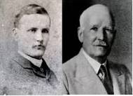
The photo on the left was taken when Middlemiss joined the
Geological Survey of India in 1882 (Courtesy of the Director Geological Survey
of India), and the one on the right from c. 1930 is from a photograph provided
by his daughter for Middlemiss's extended FRS obituary (written by Fermor).
During his service Middlemiss
did field work in the Himalaya, the Salt Range and Hazara; in Coimbatore, Salem
and the Vizagapatam Hill Tracts in the Madras Presidency; in the Shan States
and Karenni in Burma; in Bombay, Central India and Rajputana, and finally in
Kashmir. During spells at Headquarters he was Curator of the Geological Museum
in 1898-1899, and in charge of the Headquarters Office during 1907-1908. He was
promoted Deputy Superintendent in 1889, and Superintendent in 1895. He
officiated as Director of the Department for two periods, in 1914-1915 and in
1916. He paid a visit on deputation to Ceylon in 1903.
According to normal
custom Middlemiss should have retired from the Geological Survey of India on
reaching the age of 55 in 1914; but on account of the war and the difficulty of
then obtaining recruits his service was extended, so that he did not leave the
Department until 1 April 1917, after being decorated with the C.I.E. in 1916.
As a result of this Middlemiss ranks second for long service in the Geological
Survey of India, over thirty-three and a half years, the record being held by
William King with a total service of over thirty-seven years (due to his
retention in the Department until the age of sixty). Middlemiss then went
direct from the Geological Survey of India to the service of His Highness the
Maharaja of Kashmir and Jammu , with the title of Superintendent, Mineral
Survey of Jammu and Kashmir State. He did not retire from Kashmir service until
his seventy-first year, when, in the recess period of 1930, and after a total
service in India of over forty-six years, he gave much pleasure to those
geologists who had not met him by returning to Calcutta to collect a few
personal possessions and say farewell to the focus of so much active life.
HONOURS Of other
scientific activities we may record that Middlemiss became an ordinary and life
member of the Asiatic Society of Bengal in 1884, and a Fellow in 1912. At the
time of his death he was by four years the senior member of the Society (now
with the appellation 'Royal'), and also the senior Fellow. He became a Fellow of the Geological
Society in 1900 and was awarded the Lyell Medal in 1914. He was elected a
Fellow of the Royal Society in 1921. He was President of the Geological Section
of the Fourth Indian Science Bangalore in 1917. He was President of the Ninth
Indian Science Madras in 1922, and of the Mining and Geological Institute of
India in 1928. He became a Fellow of the Royal Society of Arts in 1934 and of
the American Geographical Society of New York in 1936.
MARRIED LIFE AND CHILDREN
In 1886 Middlemiss married Martha Frances Wheeler, daughter of the late General
F. Wheeler, Bengal Staff Corps. They had five sons and one daughter. Two sons
died young in India, two were killed in the last war, one in Gallipoli and one
in France, and the fifth, Hugh Percival, is pursuing a musical career. On
retiring from India Middlemiss settled down at Crowborough Sussex, where he
became a centre of local activities. Mrs Middlemiss died in July 1931. To his
daughter, Mrs. Forward, who has kept his house for him during this war, I am
indebted for help in preparing this notice, and for his photograph.
CHARACTER Before
discussing Middlemiss's work it will be pleasant to give some account of his
personal characteristics. As I and my contemporaries first knew him was already
in the forties-partially bald with an aureole of grey hair, bright blue eyes,
pleasant friendly expression, very sturdily built and above medium height. He
had an extraordinarily youthful mind, was always ready for fun, and was often
the life and soul of parties, especially if youngsters were present. Women
liked him for his courtesy and chivalry.
Middlemiss had an experimental mind and was
willing to try anything and especially anything new. The result was that he had
a multitude of interests outside geology, the principal of which were sketching
and music, as recorded in Who's Who. But he was also interested in verse, in
Esperanto, in chess, and in rowing and in lawn tennis, which he was playing in
local tournaments until he was eighty.
 ART Of these
interests the most important was sketching in water colour. From India he
recorded in this medium the incidents of camp life and travel and the scenery
amidst which he worked. Some of these sketches are very amusing and some very
charming. Fortunately he was induced recently to arrange these skethes and to
list of these sketches chronologically in a portfolio, which is now in the
possesion of his daughter. Amongst his effects there were also some framed
sketches and one of them will, it
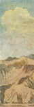
is hoped, be reproduced in a forthcoming issues of Notes and Records [This appeared in Notes and Records of the Royal Society of London, Vol. 4, No. 2. (Oct., 1946), pp. 214-215]. It is a view of the Chor Mountain, clearly visible from
Simla, and done in 1884. According to the old standing orders of the Geological
Survey of India, officers of the Department were required to illustrate their
reports with drawings and sketches, and only if they were so incompetent as to
be unable to do this were they, as a concession, allowed to use photography! As
a result, in my day, all officers of the Department were provided with a camera
lucida as a part of their camp equipment to enable them to sketch accurately
the outlines of hills and mountain scenes. Several of the earlier officers used
this aid with great effect, e.g.Thomas Oldham, Griesbach, and, facile princeps, Middlemiss.
ART Of these
interests the most important was sketching in water colour. From India he
recorded in this medium the incidents of camp life and travel and the scenery
amidst which he worked. Some of these sketches are very amusing and some very
charming. Fortunately he was induced recently to arrange these skethes and to
list of these sketches chronologically in a portfolio, which is now in the
possesion of his daughter. Amongst his effects there were also some framed
sketches and one of them will, it
is hoped, be reproduced in a forthcoming issues of Notes and Records [This appeared in Notes and Records of the Royal Society of London, Vol. 4, No. 2. (Oct., 1946), pp. 214-215]. It is a view of the Chor Mountain, clearly visible from
Simla, and done in 1884. According to the old standing orders of the Geological
Survey of India, officers of the Department were required to illustrate their
reports with drawings and sketches, and only if they were so incompetent as to
be unable to do this were they, as a concession, allowed to use photography! As
a result, in my day, all officers of the Department were provided with a camera
lucida as a part of their camp equipment to enable them to sketch accurately
the outlines of hills and mountain scenes. Several of the earlier officers used
this aid with great effect, e.g.Thomas Oldham, Griesbach, and, facile princeps, Middlemiss.
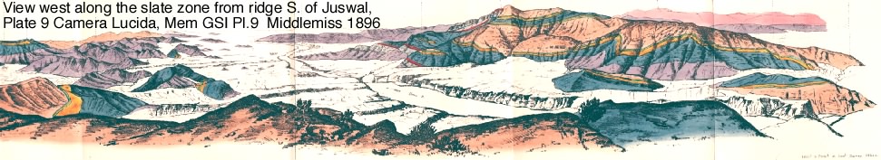
A magnificent example of what can be
done by a man of combined artistic and scientific temperament is Middlemiss's
own memoir on the Geology of Hazara and the Black Mountain (Mem. Geol. Surv.
India, 26, 1896). Amongst the numerous
illustrations are some panoramic views of which the outlines were drawn with
the aid of a camera lucida; to the panorama the geological formations have been
added using the same colours as in the geological map illustrating the memoir.
Plate 9, to choose one of several, is a superb example of the way in which
geological reports can be illustrated so as to give results far more effective
and explanatory of the scenery than are obtainable by photography. Apart
from the multitude of the usual geological sections and other illustrations that
this memoir contains, all drawn of course by the author, we may mention
specially two plates of micro-sections of rocks hand-drawn by Middlemiss and
much clearer in elucidating the composition and structure of the rocks depicted
than the majority of micro-photo graphs that are published. In this last
respect Middlemiss agreed with Harker, who also preferred to draw his own
micro-pictures of rock sections.
MUSIC Concerning
Middlemiss's second hobby, music, we must note that he comes of a musical family.
So it is not surprising that with his experimental mind, he should have looked
at music experimentally. Not being myself a musician it is suitable that I
should quote here a passage from a letter from Sir Edwin Pascoe that explains
clearly this experimental outlook:
He thought he was fond of music and so
he was in a way. But it was not so much music itself which attracted him but
the various instruments which produced it, the method of scoring it, and any
stage device for illustrating it. If Middlemiss were present at a performance
of Wagner's opera Die Walküre. I can imagine him consumed with curiosity as to
how the Valkyries on their horses were made to gallop over the clouds. While
all true lovers of drama and music would be doing their best to forget that the
figures in the stage sky were just dummies mechanically propelled with ropes
and pulleys, and trying to imagine that they were real horses and horsewomen
carrying the dead bodies of heroes to Valhalla. Middlemiss would probably been
endeavouring to invent some more realistic method of depicting the scene.
It is not surprising
that Middlemiss invented a new musical notation (see Bibliography, 1935). The
fundamental reason for this appears to have been his objection to the fact that
in the usual notation the same note may be indicated in more than one way: e.g.
that C sharp and D flat are rendered by striking the same key. On this notation
Pascoe writes to me: His musical notation was
not without merit, and he took it quite seriously. I think it failed chiefly in
that you had to read and identify every note. In our ordinary system this is
not necessary. In a rapid rise up or down the scale, for example, you do not
read every note-you have not time-but are conscious of a regular sequence. What
you have to look out for, in fact, is any irregularity or interruption in the
sequence.
VERSE & ESPERANTO
Middlemiss also amused himself with verse, and especially by experimenting
with various forms of verse. Whilst his results could not be described as
poetry they were very tolerable and readable verse. He liked especially lyrical
ingenuities such as rondeaux, rondels, ballades, triolets, etc. Middlemiss in
his enthusiasm for new methods was an active exponent of Esperanto in its early
days and acted as Honorary Secretary of the Calcutta Esperanto Society (or was
it the Esperanto Society of India?) for some years. He tried to infect the
Geological Survey of India with this new language and several of us allowed
ourselves to be dragged at his chariot wheels. For some years, in the days when
we had our lunch sent to office, Middlemiss, Vredenburg and I used to lunch
together, and invariably our greetings and conversation opened in Esperanto
before reverting to English. On my
first period of leave, in 1908, I visited Geneva, immediately after an
International Esperanto Congress had been held there. I tried in vain to make
use of the new language, and was forced to use my inferior French. On my return
to India I reported the results to Middlemiss and Vredenburg and cut myself
adrift from Esperanto. But Middlemiss carried on for some years. I have heard
of one example of Esperanto proving useful. Hayden (later Sir Henry Hayden)
when on duty in Afghanistan used it in writing to headquarters in Calcutta, for
his letters if opened en route would be understood by no one!
The difficulty that faces inventors of new languages like Esperanto, or
even Basic English, or new systems of musical notation like Middlemiss's, is
that even if that new language or system is better than the old, it stands no
chance of replacing existing languages or systems. For by learning the new you
cannot thereby avoid also learning the old, for the simple reasons that all
preceding work has been published in existing languages or notation, and that
there is not the remotest possibility that the whole corpus of these past works
will be translated into the new tongue or rewritten in the new notation.
To young officers in the Department Middlemiss was very helpful, both in
the field and at Headquarters. I did not have the advantage of working under
him in the field, but I must recall his kindness to me when I offered my first
paper for publication by the Geological Survey. Sir Thomas Holland, then
Director, had introduced the custom of circulating papers for criticism amongst
officers, starting with the most junior and ending with the most senior, before
it went to the Director himself. My paper reached Middlemiss near the end of
its round, and in it he, being a master of English composition, found many
passages that could be better expressed. Instead of commenting on this on the
file he brought the manuscript to me, and we went through it together and made
the necessary improvements before the paper went further.
In spite of his obviously
happy nature Middlemiss occasionally had violent fits of temper, a fault of
which no one was more conscious than he. He was never above telling stories
against himself, and the difficulties his temper got him into. One story may be
permitted here, as it illustrates Middlemiss. I am indebted for it to Sir Edwin
Pascoe to whom it was told by Middlemiss himself. It is the story of
Middlemiss's old bearer and the scones. One day in camp the old man angered him
in some way, with the result that Mlddlemiss sacked him on the spot. The old
servant duly packed up and disappeared. Now the old man was very clever at
making scones and Middlemiss was very fond of scones for tea. That afternoon,
however, there were no scones when Middlemiss returned from his work. When the
next day came and there were again no scones Middlemiss began to wonder whether
he had not been a little hasty. On the third day, to his surprise and delight,
there appeared a dish of his usual scones, and soon after the old bearer
himself carrying on as if nothing had happened. When asked how he dared to come
back after he had been sacked, the old man's answer was; 'Well, Sahib, you and I have been Master and
servant together for over twenty years, and I guess we shall go on being so
until one of us dies!' And they did; it was the old man who died.
GEOLOGICAL WORK During
his long term of service in the Geological Survey of India, Middlemiss spent
but a small proportion of his time at Headquarters, except for the normal
recess season. He was at Headquarters for a short time as Curator of the Museum
and Laboratory and on another occasion was in charge of the offices; whilst at
the end of his service he officiated twice as Director of the Department.
Fortunately for the scientific world he was never a permanently Director, as
his talents did not extend to administrative activty and official
correspondence. Instead he was essentially a field geologist who liked a direct
appeal to the facts of Nature as displayed in the field and elucidated by the
hammer; though he was glad, of course, to confirm and support these results by
work at Headquarters during the recess, by means of the microscope and specific
gravity determinations.
His total service in India can
be divided into three spells. The first, of some ten years' duration, was spent
in North-Western India in the Himalaya, the Salt Range and Hazara. The second
spell was twent-two years long and was devoted mainly to the problems of
Peninsular India, starting with some ten years in the Madras Presidency (the
Salem and Coimbatore districts and the Vizagapatam Hill Tracts) with a Burma
and a Ceylon interlude, followed by some twelve years in charge of the Central
India and Rajputana Party (later the Bombay, Central India and Rajputana Party)
of the Geological Survey of India, with interludes for the headquarters duties
mentioned above. From 1908 to 1913 Middlemiss combined winter work in Central
India and Rajputana with summer work in Kashmir, so that on retiring from the
Geological Survey of India in 1917 he was in trim for his new appointment as
Superintendent of the Mineral Survey of Jammu and Kasmir, a post that he held
until 1930, giving him a total third spell, in Kashmir, spread at intervals
over some twenty-two years; the second and third spells thus overlapped, and
the whole gave him a total of forty-six years' service in India.
The first and second spells
were punctuated by earthquake investigations, namely the Bengal earthquake of
1885, the Kangra earthquake of 1905, and the two Calcutta earthquakes of
1906. Middlemiss's most fruitful
work was done in North-Western India, scientifically during his first
spell in the Himalaya and Hazara, and scientifically and economically during
his third spell in Kashmir, whilst his investigation of the Kangra earthquake
during his second spell acted as a mountain refresher. The middle spell was
not so fruitful, at least as represented by published work, and Middlemiss
appears to have been less happy upon the Archaean rocks of the Peninsula, where
petrographical studies play such a large part and where it is difficult to work
successfully on a broad scale, than he was in ExtraPeninsular tracts,
mainly occupied by younger formations, where broadr stratigraphical
problems prevail and where the age and relationships of the rocks in most cases
have not been so greatly obscured by the operation of intense metamorphic
processes.
JANUARY 1884 WITH OLDHAM TO
JAUNSAR For his introduction to Indian geology Middlemiss was sent
out with R. D. Oldham, whom he joined in the field in January 1884. Oldham was
working in the Jaunsar Bawar tract of the Lower Himalaya behind Dehra Dun, and
as a result of this experience Middlemiss saw not only the Himalayan rock
formations of Oldham's tract, but also the sub-Himalayan tract of Dehra Dun
described by H. B. Medlicott·in his classic memoir of 1864 (Mem. Geol. Surv.
India, 3). Whether Middlemiss actually got
as far west as the Chor Mountain in the Simla Himalaya does not appear, but
that he went close thereto is proved by the water-colour sketch referred to on
page 264, the sketch being dated 1884; and by the reference in his third paper
(Rec. Geol. Surv. India, 22, 29).
From Chakrata in Jaunsar Bawar Middlemiss marched through Tehri Garhwal to
British Garhwal to the east, which with Kumaon still farther east was to form
his hunting ground for some six field seasons.
Middlemiss's work in Garhwal and
Kumaon may be divided into two sections, namely that on the Himalayan
formations, mainly pre-Tertiary, constituting the Lesser Himalaya, and that on
the Sub-Himalayan formations, mainly Siwaliks, forming the outer fringe of the
Himalaya. The latter work was done the later; but as it was brought to complete
fruition in Middlemiss's important and illuminating memoir on the 'Physical
Geology of the Sub Himalaya of Garhwal and Kumaon' (Mem. Geol. Surv.
India, 24, Part 2), a memoir
that has already assumed the position of a classic illustrated with classic
sections, it may be noted first. In this work he mapped completely the
Sub-Himalayan tract from the Ganges on the north-west to the Sarda river on the
Nepal frontier to the south-east,his survey being designed as an extension in a
south-easterly direction of the geological work described by Medlicott. Owing
to the possession of better maps-partly on the scale of l-inch to the mile and
partly, in the Reserved Forests, on the scale of 4 inches to the mile
Middlemiss was able to work in much greater detail than Medlicott, so that he
was able, using his own modest phraseology, to amplify and modify Medlicott's
work.
STRUCTURE OF THE HIMALAYA
The essence of Middlemiss's work was to show that the Sub-Himalaya is divisible
into roughly parallel strips of Siwalik strata separated by reversed faults so
that in every case a younger division is dipping under an older one to the
north-east. At one cross-section he maps five successive reversed faults, of
which two are within the Siwaliks, one separates the Lower Siwaliks (Nahans)
from the Great Limestone of the Lesser Himalaya to the north, and the other
two, still farther north, separate zones of the Himalayan formations. He
regards each of these reversed faults as representing approximately the
position of an ancient shore-line or mountain-foot so that these reversed faults
are at the same time in a certain measure limits of deposition for the
formation immediately south of each (loc. cit. pp. 118-119). They are also
successively younger as one approaches the plains, corresponding with the
deposition of later sediments of the plains side of the range. Consequently the
range continues to grow by fresh additions to itself, like a coral, by the
incorporation of its offspring with itself (loc. cit. p. 133). His reasoning
leads him also to suppose that there must be a reversed fault between the
outermost belt of Siwaliks and the Gangetic alluvium and that consequently the
Himalayan range is still growing. Further, he is confident that before the
deposition of the Siwaliks began the Himalayan range was already in existence
much as we know it now, and that it is highly probable that a barrier of
crystalline rocks existed in Tertiary times between the Sub-Himalayan deposits
of this side and those of Hundes (loc. cit. p. 115).
OSMOND FISHER AND ISOSTACY
As illustrating Middlemiss's readiness
to use new ideas, it is
interesting to note that in discussing the bearing of his work on the theory of
mountain formation he welcomed Osmond Fisher's Physics of the Earth's Crust,
first published in 1881, in which is proposed the hypothesis that the crust of
the earth is in a state of approximate hydrostatical equilibrium so that the
Himalayan mountain range has been rising pari passu with decrease of load, as by denudation it supplied
sediment to the plains at the foot, which themselves have continued to
sink under the burden of increasing load. The term isostasy1 now
used to describe this state of hydrostatic equilibrium was not proposed by
Dutton until 1889, and this term had evidently not reached Middlemiss when he
wrote his memoir, published in 1890.
Both Osmond Fisher and Middlemiss, however, must be described as
isostasists, and in later works Middlemiss uses the term freely.
Pascoe's Footnote #1. It evidently took some time for this
term to reach India. For R. D. Oldham*,
influenced perhaps by Middlemiss's writings, introduced Fisher's views in
discussing the uplift of the Himalaya in the second edition of the Manual of
the Geology of India, published in 1894, without using this term. Strange to
say, this term has not yet reached the Shorter Oxford English Dictionary (in
two volumes second edition 1933,
reprint of 1939). It does, however, appear in adjectival form in Chamber's
Twentieth Century Dictionary, dated 1903.
*comment: Oldham's
first mention of any of Fisher's theories is in an article published in 1884 in
the Asiatic Society on fossil synchroneity, in which he discusses conflicting
evidence for changes in latitude through paleoogeographic climate change.
Middlemiss joined Oldham in the field in January 1884 and it is very likely
they discussed Fisher's theories at this time. Fisher had published a Geological Magazine article on
changes of latitude as early as July 1878 which Oldham might have read before
leaving for India. The first
edition of Fisher's book was published in 1881, and its second enlarged edition
in 1894.
ANCIENT RIVERS AND GRAVELS
In our obituary notice of Dr. G. E. Pilgrim we mentioned the suggestion
advanced independently by Pilgrim and Sir Edwin Pascoe, and based on two quite
different lines of approach, that the three main rivers of northern India, the
Brahmaputra, the Ganges and the Indus, were once part of a single river rising
in Assam, flowing north-west along the foot of the rising Himalaya and then
turning south-west towards the Arabian Sea, the course being demarked
demarcated by the distribution of the Siwalik Boulder Conglomerates. This river
was called the Siwalik river by Pilgrim and the Indobrahm by Pascoe. Middlemiss's memoir contains a detailed
survey of a portion of the course of this supposed river. I do not know if
Middlemiss accepted this idea of Pilgrim and Pascoe, but it seems necessary to
note here that his memoir contains a passage that appears to disagree with
their hypothesis. He writes (p. 120):
Nothing is more clearly
demonstrated in the whole range of Sub-Himalayan geology than the connexion
between the position of the debouchure of the present large rivers and the
deposits of Siwalik conglomerate. That being so, we are bound to believe that
these deposits were formed by the direct parents of those rivers, in the places
where they are now found.
This means that the separate patches of Siwalik conglomerate
shown on Middlemiss's map cannot be regarded as sections of a continuous strip
of conglomerate parallel to the Himalaya, but coincide in position with the
places where the ancestors of the present Ganges and Kosi emerged from the
hills2. {Footnote 2 Pilgrim, working on the Panjab section of
the Himalaya came to a different conclusion and found the conglomerates
continuous between the debouchures of the transverse Himalayan streams}.
NAPPES Before he made
his studies of the Sub-Himalayan belt, so happily brought to fruition in the
memoir discussed above, Middlemiss had begun his survey of the belt of Lesser
Himalayan formations lying to the north of the SubHimalayan tract, work
which, though continued at the appropriate season of the year for as long as he
was engaged in this part of India, was not carried to completion before he was
detached for work elsewhere. Nevertheless, Middlemiss's work on the Himalayan
formations is discussed by him in a series of papers in the Records of the
Geological Survey of India, of which the most important is his 'Physical
Geology of West British Garhwal' (Rec.
Geol. Surv. India, 20,
26-40), published in 1887. This paper contains the results of a very careful
survey on the 1-inch scale, with his published map on the quarter-inch scale,
of a tract of country the geology of which was previously unknown. This paper
records in fact the results of the first detailed geological survey of any
portion of the Himalaya. The tract described contains an elliptical area
(within which is Kalogarhi mountain composed of gneissose granite), arranged
parallel to the Himalayan axis, of schistose rocks (Middlemiss's Inner
formation) encircled by a belt of unmetamorphosed sedimentary strata
(Middlemiss's Outer formations) shown by Middlemiss to be at least in part of
Eocene (Nummulitic) and Mesozoic age (Tal beds). Middlemiss decides that the
Inner schistose rocks are older than the Outer, unmetamorphosed, formations, in
spite of the fact that his survey disclosed a very remarkable arrangement of
the rocks, namely that everywhere round the ellipse the encircling younger
Outer formations dipped towards and apparently under the Inner formation, the
older schistose series, so that it was (p. 36):
difficult to get rid of
the first impression already alluded to that the whole is asynclinal trough
with the Outer formations below, and the Inner above. One seems almost driven
to conclude that if a boring were sunk through the centre of the schistose
area, we should inevitably strike the Tal beds below.
Middlemiss resisted this conclusion and instead explained
the structure by showing that everywhere the younger outer formations dipped
under the older inner formation along reversed faults or thrust planes: in fact
he appears to have regarded the Outer formations as being everywhere tucked in
under the Inner formation without supposing that this reversed relationship
extended continuously under the syncline.
INVERTED METAMORPHISM In
our obituary notice of Pilgrim we noted how that great geologist Medlicott in
his discussion of the stratigraphy of the Simla Hills was 'at first tempted to look for grand inversion of
strata', and how by failing to yield to temptation he missed the
truth and left the problem for Pilgrim and West to solve some sixty years
later. If the second great Himalayan geologist, Middlemiss, had accepted the
conclusion that his hypothetical boring would have struck the younger rocks
under the older in the middle of the syncline he would not have left the
problem to be solved by J. B. Auden (Rec. Geol. Surv. India, 71, 407-433 (1937)) some fifty years
later. The combined work of Pilgrim, West and Auden has shown us that the
anomalous relations of geological formations on the grand scale in the Himalaya
are to be explained in terms of repeated overthrust nappes of formations thrust
bodily outwards, i.e. southwesterly, from the Central Himalayan direction
for many miles over the autochthonous formations of the Outer or Lesser
Himalaya, with subsequent denudation producing scattered windows through which
scattered views of the underlying
formations can be obtained. How many of us, if working as long ago as Medlicott
and Middlemiss, would have stood on the brink of these great discoveries and
not have missed them! But these
two geologists laid solid foundations on which others have built. Auden
records the excitement with which he and West independently read Middlemiss's
paper on West Garhwal and wondered if he was really describing a nappe without
realizing it.
In this West Garhwal
paper, and a second paper (Rec. Geol. Surv. India, 20, 134-143) discussing the geology of
the Dudatoli Mountain, Middlemiss describes the distribution of a garnetiferous
aureole round the intrusive gneissose granite and recognizes the strong
resemblance of the Kalo garhi (Lansdowne), Dudatoli and Chor mountai ns both in
rock composition and in geological structure. He regards the granite as intrusive in the schists, but is
very cautious on the source from which it was derived. We know now that these
granites with their associated schistose rocks form parts of nappes of strata
derived from the north-east.
From Middlemiss's Memoir on the
Geology of the Sub-Himalaya one learns that he hoped later to write a
comprehensive memoir on the geology of the Himalayan belt of Garhwal and
Kumaon, of which his papers in the Records, including the two just discussed,
were forerunners. His transference to the Salt Range and Hazara before he had
completed his field surveys of Garhwal and Kumaon would not have been a
geological tragedy if he had been allowed later to return to the Himalaya and
complete the work for this memoir.
Had he done so, would he have failed finally to arrive at the truth and
recognize the large-scale overthrusting, instead of leaving the problem
unsettled for fifty years? Truly
the responsibilities of Directors of Geological Surveys are sometimes very
great, especially when they have to balance the rival claims of a short-term
policy directed to the immediate appraisal of the value of mineral deposits of
possible economic value against those of a long-term policy directed to the
understanding of the geology of a country, upon which ultimately depends
knowledge of the distribution of the known mineral deposits and of the
possibilities of additional discoveries. (See Rec. Geol. Surv. India, 24, 27.)
MOBILITY OF SALT The discovery by
Warth, in 1888, of Cambrian trilobites in the Salt Range of the Panjab was the
cause of Middlemiss being sent there in 1889 and 1890 to investigate this and
other problems that had arisen in that field of research. As a result many more
trilobites were found and Middlemiss produced a brilliant paper on the geology
of the Salt Range 'with a re-considered theory of the Origin and Age of the
Salt Marl' (Rec. Geol. Surv.
India, 24, 19-42 (1891)). At
the time of his visit Wynne's view held the field, namely, that the Saline
series, a term used to designate the Salt Marl and its associated gypsum and
rock salt, was in its normal stratigraphical position at the foot of the Salt
Range, beneath the Purple Sandstone, and therefore either Cambrian or preCambrian
in age. From Middlemiss's careful sections and descriptions it is seen,
however, that the Salt Marl never shows a normal sedimentary contact with the
overlying Purple Sandstone nor with overlying younger beds (Carboniferous
or Tertiary). Having devoted a large portion of his paper to exact description,
in his usual methodical manner, Middlemiss th en allows his speculative
faculties full play and considers the implications of the 'anomalous
quasi-intrusive relations' of the Salt Marl
to other formations. He asks (loc. cit. p. 42):
Can we see in it anything of the nature of
a scum, such as we might picture to ourselves as having partly secreted at the
surface of an ancient untapped magma, and partly resulted from that secretion
by induced changes in the overlying dolomitic strata?
If we can, we have but to give the
substance a gently intrusive or injective impetus, followed by consolidation,
some time during the Tertiary period, to account for all the otherwise perplexing
circumstances under which the salt-bearing beds of the Panjab are found.
From Middlemiss's paper it will be seen that the date of the
disturbances that he interprets in this manner must have been post-Middle
Siwalik (post Miocene) .
Since Middlemiss wrote, intrusive salt domes and plugs have
become a commonplace of geology and such domes, composed of salt of Cambrian
age, but of late tectonic production, have been found widely distributed in
Persia; it is now considered unnecessary to postulate the existence of a
subterranean magma, and geologists are satisfied that the incompetence of
saline beds under tectonic pressure provides an adequate explanation of the
phenomena so graphically described by Middlemiss.
SALT RANGE SALT AGE
CONTROVERSY With
this paper Middlemiss initiated the controversy that is still unsettled concerning the age of the Saline series of the Salt Range, whether it is
Cambrian (or pre-Cambrian), or whether it is post-nummulitic in age and has
acted as the sole of a large-scale overthrust of the whole mass of the Salt
Range over Tertiary saline beds. According to the recent careful re-survey of
the whole of the Salt Range carried out over several years by Mr E. R. Gee of
the Geological Survey of India, the Saline series is of Cambrian (or pre-Cambrian) age and the abnormal relations to other formations so carefully
described by Middlemiss are due to the incompetence and plastic nature of the
materials of the Saline series; all the other stratigraphers who have examined
the ground recently are in accord with Mr Gee on this interpretation. But in
apparent support of the Tertiary age of the salt, Professor Birbal Sahni and
his associates have discovered plant and other organic remains of Tertiary to
Recent age apparently embedded in the Salt Marl and associated beds. The
problem is still, therefore, subjudice,
and to help solve it Professor Sahni has arranged two symposia, one of which
has already been held and its results published. To the first symposium
Middlemiss in his eighty-fourth year has contributed a short note (Proc. Nat. Acad. Sci. India, 14, Sect. B, 267-268) in which he
claims that his theory of :
intrusive Salt Marl of the
Salt Range is in harmony with up-to-date requirements and need no longer be
silently dismissed as a rash speculation; even though acceptance of the possible
guess at the end of my paper that an igneous magma may have been ultimately
responsible; is too much to expect.
The flat contradiction between the evidence of stratigraphy
and that of palaeontology referred to above may eventually be resolved by the
recognition that in view of the plastic nature of the saline beds under
pressure, and the solubility of the salt, any fossil remains found therein may
be exotic, and that Saline beds of Cambrian or pre-Cambrian age have been
caused to behave in post-Miocene times in the quasi-intrusive manner described
by Middlemiss and have thereby acquired Tertiary and Recent characteristics in
the form of enclosed Ranikot foraminifera and plant remains of Tertiary and
Recent age.
[The controversy is over: it is now generally accepted that Gee is correct and that Cambrian salt has incorporated later fossils through the process of flow. The salts permits the displacement of the Potwar plateau SSE at about 7 mm/yr]
Kashmir
and the Hazara Syntaxis From the Salt Range,
Middlemiss, in 1890, was sent to Hazara, now in the North-West Frontier
Province [of Pakistan], to study the coal of the Dore River, and this led to
his being sent to make a continuous survey of the whole of the southern half of
Hazara, following the previous disconnected and unfinished work of Wynne and
Waagen, and including a visit to the Black Mountain country during a military
campaign. This work lasted until 1893 and resulted in Middlemiss's splendid
memoir on 'The Geology of Hazara and the Black Mountain', published in 1896 (Mem. Geol. Surv.
India, 26).
Although the mountains of Hazara belong to the Hindu Kush system of
folding with its N.E. strike and are not geographically a part of the Himalayan
system of ranges with their N.W. strike in Kashmir next door to Hazara, yet
geologically the Hazara mountains are composed of rock formations continuous
with those of the Himalayan belts in Kashmir, the sharp bend of strike taking
place north of the hairpin bend of the Jhelum River near Muzaffarabad. As a result, in his survey of Hazara,
Middlemiss was studying stratigraphical belts analogous to those already
partially surveyed in Garhwal and Kumaon. As in Garhwal and Kumaon he divides
his country into zones of disturbance or elongated blocks of formations that
lie parallel to the general strike of the country. He recognizes four such
zones (lo cit.p.87):
NNW (A)
Crystalline and metamorphic zone.
(B) Slate, or Abbottabad zone .
(C) Nummulitic zone.
SSE (D)
Upper Tertiary zone .
He calls A the 'innermost zone' and D the 'outermost zone',
and describes and discusses each separately; and then, comparing them in
respect of the amount of elevation, compression and denudation they have
suffered, he finds that (loc. cit. p. 265):
zone A has been most elevated, most compressed, and
most denuded; whilst we travel south-east through the other zones in order we
find that they have successively been less elevated , less compressed, and less
denuded.
On the south side of each of the three northern zones of
disturbance is a boundary fault by which each zone has been thrust over the
next zone to the south. Middlemiss ranges the zones in order of age A > B
> C > D and regards the boundary faults as similarly successive in age.
Further, discussing how this succession has been produced, he writes (loc. cit.
p. 280):
At stated periods as we
have seen, after a certain packing of the
rocks had taken place, a great block of such rocks has yielded as a
whole and gone sliding over the one to the south, or under the zone to the
north, producing a thrust-plane, and marking off two disturbance zones from
each other.
Middlemiss does not use the term nappe, but as he recognizes
the similarity of the structural arrangements of Hazara to those of the Himalaya
in Garhwal and Kumaon it seems probable that he is really describing, in the
passage quoted above, overthrust nappes, and that a re-examination of Hazara by
one familiar with nappe structure and modern terminology would show this. Also
it seems to follow that had Middlemiss returned to his earlier hunting-grounds
in Garhwal and Kumaon he would have revised his interpretation of such
structures as the Kalogarhi (or Lansdowne) synclinal. [Note: Both nappe
structures, if unfolded, and Middlemiss's sliding, require for their
explanation that the original thrust-planes must have been of low angle. In a
much later paper (1919) resulting from his surveys in Jammu and Kashmir ,
Middlemiss. succeeds In measuring
the inclination of the thrust-plane or reversed fault between the Siwalik and
Miocene zones, of formations ncar Kotli in Jammu . He shows it to be from 12°
to 15° only. (See Rec. Geol. Surv. India,
50, 122. He was the first to demonstrate this fact, which is all
the more important because it relates to what is often termed the Main Boundary
Fault of the Himalaya. (See also Fermor, Rec. Geal. Surv. India, 62,410 (1930).]
In his discussion of his
oldest zone in Hazara, the crystalline and metamorphic zone A, the only zone in
which igneous intrusives have played a part, a zone in which the youngest
formation is his Infra-Trias (now regarded as Permo-Carboniferous in age) and
its metamorphosed equivalents (the 'Tanols or Tanawals'), Middlemiss
points out that this is the only zone in which igneous intrusion has played a
part, and that, therefore, the intrusion of the gneissose granite must have
been pre-Triassic in date and post-Infra-Trias. Middlemiss's next zone, B,
contains rocks ranging in age from his oldest series, his Slate series (Attock
slates), to Tertiary, and none of them are intruded by the gneissose granite .
Whether Middlemiss would have
adhered to his view that the gneissose granite of Hazara was pre-Triassic in
age, if he had considered that the only one of his zones of disturbance that
contains intrusive gneissose granite was a nappe brought into position possibly
from far to the north-west, is of course unknown. What he does do is to enlarge
on the unity of the gneissose granite of Hazara with that of the Central
Himalaya and thereby to ascribe a similar age-to the latter. This leads him to
disagree with the views of MacMahon and others that the Himalayan ranges must
be entirely Tertiary in age. As always, he is cautious, and not dogmatic in
dealing with such a problem. Thus, whilst as before he urges (loc. cit. p. 284)
'the probable great age of the Himalaya as
opposed to the popular ideas that they were the product of yesterday, geologically
speaking', he guards himself against misconception. by referring to
the far-reaching views of the Rev. Osmond Fisher, and says (loc. cit. p. 285)
that it has been gradually becoming evident to all who really examine the
question that the Himalaya are and have been in a constant state of change so
that 'one might say literally that the
Himalaya of to-day are not the same as those of yesterday'. But to
be more precise Middlemiss writes :
Hence in speaking of the
Himalaya of a past geological age or epoch we mean, or at least I mean, that
old representative of them which held about the same position and acted
functionally in the same way as does the mountain-range going by the name of
Himalaya to-day. It may not always have been of the same height as the Himalaya
of to-day . It may sometimes have been represented by long parallel coast
lines, or by archipelagos with chains of mountainous islands following similar
parallel li es, but that it kept certain original features, and that a mountain
core recognizable in its unity" persisted t rough Tertiary, Secondary and
possibly into Palaeozoic times, I have no doubt.
The above is summarized in the final sentence of this
magnificent memoir:
Rome was not built in a day, neither were the
Himalaya either.
As indicating the philosophic attitude of Middlemiss to
every type of problem, it is worth mentioning that although the gneissose
granite of Hazara has demonstrably acted as an intrusive rock to the
sedimentary formations yet Middlemiss is prepared for this rock to be either a
gneissose granite or a granitic gneiss (loc. cit. p. 278) and therefore would
not regard the views of the French school now adopted by many modern
investigators in Britain and elsewhere, namely, that some granites at least may
be thoroughly metamorphosed and melted sediments, as incompatible with the
field evidence. For he refers to the crystalline core of the Himalaya with the
following words (loc. cit. p. 278): whether
we consider it as a thorough granite or as a slumbering gneiss that at one time
became functional as a granite. Middlemiss also draws attention to
the uniformity of petrological characters of this granitic or gneissic rock
right through the Himalaya from end to end 'as
far as observations have gone', as well as in Hazara, and contrasts
this fact with the state of affairs in Southern India, where 'there is no
uniformity whatever as regards the gneissic foundations of the peninsula'
(loc.cit.p.275).
On completing this work in
Hazara Middlemiss was not sent back to Garhwal and Kumaon, as might have been
hoped, but to the Madras Presidency, thus commencing his second or Peninsular
period of work. Instead of next discussing this it seems better to refer first
to his earthquake work and then to his third period in Jammu and Kashmir.
EARTHQUAKES Northern
India, as is well known, is situated on one of the earth's main earthquake
belts, the Indian section striking first north-north-east along the Baluchistan
and North-West Frontier ranges and then south-east and east parallel to the
Himalayan ranges as far as Assam, where it turns south-west to south through
the Assam-Burma ranges. This is a zone of instability, residual from the
Tertiary period, of over-thrusting of Extra-Peninsular India against the massif
of the Peninsula (or vice versa), a period that still continues and will
continue as long as the Himalaya and geologically related ranges are still in
active movement and process of formation. In consequence, India is subject to
earthquake shocks, often of disastrous magnitude, at unequal and at
present unpredictable intervals. In India the field investigation and
study of earthquakes is one of the duties of the Geological Survey.
Consequently, as it is imperative that the evidence presented by earthquake
shocks should be recorded at the earliest possible moment, while it is still
fresh, officers of the Geological Survey of India are liable to find themselves
ordered by telegram at a moment's notice to the scene of some important and
often disastrous earthquake.
Middlemiss during
his career had to investigate the violent Bengal earthquake of 14 July
1885, two mild Calcutta earthquakes of 1906, and the disastrous Kangra
earthquake of 1905. We need discuss only the Kangra earthquake, which was one
of first magnitude and, as judged by loss of human life (over 20,000), one of
the most disastrous of modern times. Middlemiss and three other officers
were despatched to the scene with Middlemiss as senior officer in charge.
Middlemiss, with his previous Himalayan experience, was particularly suited for
the study of this problem, and it fell to him to compile all the evidence
collected from many sources, and as a result he produced another fine memoir (The
Kangra Earthquake of 4th April 1905,
Mem. Geol. Surv. India,
38, 1910).
In this memoir Middlemiss
records all the relevant facts collected and then discusses the cause of the
earthquake. This particular earthquake was peculiar because there were two foci
or epicentral tracts, the larger one, with a maximum intensity of 10 on the
Rossi-Forel scale, being at Dharmsala and Kangra in the Kangra Valley, whilst
the subsidiary epicentral tract, with a maximum intensity of 8, was in Dehra
Dun, with Dehra Dun and Mussoorie as the principal towns. These two foci are
situated where the Sub-Himalayan zone of Tertiary formations embays in a
north-easterly direction into the Lesser Himalayan zone, leaving between them a
south-west-pointing bulge or bastion of Lesser Himalayan formations - that on
which Simla stands. Middlemiss points out that these two embayments are the
only such along the whole length of the Himalaya as far as this is known and
that they must be regarded as places where the Sub-Himalayan belt has not been
straightened out along the over-thrust plane- the Main Boundary fault of the
Himalaya- that separates it from the Lesser Himalayan belt to the north-east.
He mentions other important features connected with the distribution of these
two epicentres, and concludes that the earthquake was of deep-seated tectonic
origin. This view of the origin (loc. cit. p. 340): implies that the shock was
due to a sudden rupture or release of strain occurring among or below the
folded sub-Himalayan formations at two places where the strain was specialy
great owing to resistances to the well-established forward march of the overthrusting
foot of the Himalayan range and where packing, with consequent arching , may
have brought about a certain loss of isostasy.
FOSSILS The
important discovery of the Gondwana fossil plant Gangamopteris by Oetling in
the Vihi district of Kashmir, and subsequent research by R. D. Oldham, Hayden,
Smith Woodward and Seward on this locality or on fossils therefrom had shown
the necessity for a thorou gh examination of such an important area, offering
as it did the possibility of correlating the great freshwater Gondwana
formation of Peninsular India with the richly fossiliferous marine sedimentary
systems of the Himalayan area-two widely distinct geological provinces not till
then ever found in juxtaposition. Middlemiss was entrusted with this task and
spent thereon the summers of 1908 and 1909. In crossing the Golabgarh pass into
Kashmir he found a supremely important section with two fossil-plant horizons
containing Gangamopteris and Glossoperis, of species suggesting respectively
the Talchir and Karharbari beds of the Peninsula. These beds were overlain in
due course by a limestone containing Protoretepora ampla Lonsd. and other
fossils identifying it with the Zewan beds of the Vihi section. Middlemiss had
made a most important discovery and thereby established the Permo-Carboniferous
(Artinskian) age of the lowest beds of the Gondwanas of the Peninsula of India,
and placed these beds in their correct position with reference to the marine
fossil sequence of Kashmir (Rec. Geol. Surv. India, 37, 296 (1909)), and therefore of the
world.
REMAPPING KASHMIR An
incidental result of this visit to Kashmir was the discovery that the
geological map published by Lydekker in his memoir on the geology of Kashmir,
Chamba and Khagan (Mem. Geol. Surv. India,
22 (1883), had been made
on too small a scale, and too rapidly, to satisfy modern requirements;
and as a result Middlemiss had to re-lay the foundations of our knowledge of
the stratigraphy of Kashmir . (See his paper on 'A Revision of the
Silurian-Trias Sequence in Kashmir'. Rec.
Geol. Surv. India, 40, 206-260 (1910).) In addition he returned
to Kashmir in 1910 and rewrote our knowledge of the Pir Panjal, the Outer or
Lesser Himalayan range separating Jammu from Kashmir (Rec. Geol. Surv. India, 41, ll5-144 (1911).) These studies
enabled him to apply to Kashmir and Jammu his ideas of the 'successive zonal
imbrication' of Hazara (loc. cit. p. 136) already mentioned and he succeeded in
recognizing three zones in the part of Kashmir visited by him: (1) the
Sub-Himalayan and Nummulitic zone combined, (2) the Pir-Panjal or Carbo-Trias
zone, and (3) an older zone or zones containing large areas of rocks of
Silurian age. These may be compared with his four Hazara zones listed on page
274.
Although
Middlemiss continued work in Kashmir in 1912 and 1913, with a newly recruited
officer, H. S. Bion, he did not contribute any further papers on this work
before he retired from the Geological Survey of India in 1917 and became
Superintendent of the Mineral Survey of Jammu and Kashmir. Most of his attention in his new
appointment was necessarily directed to the discovery and study of mineral
deposits of economic value. But before we discuss this it is necessary to point
out that in his surveys in Kashmir between 1909 and 1913 Middlemiss cleaned the
slate of previous error and wrote on it the foundations of the geology of
Kashmir to serve as a source of inspiration to his successors. The first
legatee was Bion, who had been inducted into Kashmir geology by Middlemiss in
1912 and 1913 and had nearly completed his description of 'The Fauna of the
Agglomerate Series of Kashmir' when he died
prematurely in June 1915. Some years later this study was issued as a memoir in
the Palaeontologia Indica (n.s, 12, 1--42 (1928)) with an introductory
chapter by Middlemiss. The chief interest of this chapter is Middlemiss's
views on the Panjal Volcanics consisting of the Agglomeratic Slate below and
the Panjal Trap above, with interbedding of trap flows in the upper part of the
Agglomeratic Slate. 'On the origin of the Agglomeratic Slate Middlemiss is not dogmatic, but he inclines to the
explosive volcanic theory, the fragmental beds containing intercalated beds
with the marine fossils described by Bion (principally species of Spirifer and
other brachiopods), the age being Carboniferous (Moscovian and Uralian). The
generally overlying Panjal Traps are of basaltic composition, like the
Deccan Traps of the Peninsula, but are of much greater age. A point of much
interest brought out by Middlemiss is the variable horizon of the Panjal Traps,
so that the horizon of the base of the Trap varies from Middle Carboniferous to
PermoCarboniferous, whilst the upper limit of the Trap ranges from
Permo-Carboniferous to as high as the Upper Trias: so that vulcanicity
began in one neighbourhood in Middle Carboniferous times and eventually ended
elsewhere in the same neighbourhood at the close of the Middle Trias.
Nevertheless Middlemiss regards these Traps as mainly of extrusive origin, a
conclusion acceptable to others who have worked in this country.
WADIA A man' s work
must be judged partly by the extent to which it benefits and inspires those who
follow him. By this test Middlemiss stands high. Bion died young, but D. N.
Wadia succeeded in due course to the legacy and in a series of good papers and
a massive memoir has built well on the foundations of the new geology of
Kashmir laid by Middlemiss, and has been awarded by the Geological Society of
London the same medal, the Lyell Medal, as was awarded to Middlemiss.
MINERALS KASHMIR On joining
his new appointment of Superintendent of the 'Mineral Survey of Jammu and
Kashmir', Middlemiss's primary duty became the investigation of the mineral
deposits of these territories, with the aid of his assistants. His earlier
papers on these minerals are in the Records of the Geological Survey of India
and relate to aquamarines (with L. J. Prashad), petroleum and lignite. Of these
the most important is his paper on the 'Possible Occurrence of Petroleum in
Jammu Province', in which he describes a
structure (which he calls the Nar-Budhan dome) in the form of 'a natural reservoir of the best type, suitable for
the underground concentration and storage of oil' occurring in rocks
of age, structure and lithological character identical with those of the neighbouring
oil region of the Rawalpindi plateau (Rec. Geol. Surv. India, 49, 191 (1919)). From this paper it is
seen that this was not an accidental discovery, but resulted from a deliberate
search based on general grounds of possibilities, and after Middlemiss had made
a visit to the Khaur field. Middlemiss decides that the crest beds of his dome
are almost certainly lower in the series than the crest beds of the Dhulian
dome (now producing oil in the Panjab). Middlemiss's dome has not yet been
tested by any oil company, as far as is known to me, perhaps because of the
absence of seepages, or perhaps from fear of the effects of a fault mapped by
Middlemiss. It was as a part of this work that Middlemiss made his measurement
of the inclination of the Main Boundary Fault at Kotli noticed in the footnote
on page 274.
Reports
from Kashmir In 1922 his
department commenced its own publication under the title of Reports of the
Mineral Survey of Jammu and Kashmir, and between 1922 and 1931 no less than
nine of these reports issued from Middlemiss's pen, amply
illustrated with maps and sections, describing mineral
occurrences of the State examined by him and his assistants, many of the
mineral deposits being fresh discoveries by his department. The titles of these
reports are given in the Bibliography. Most of the mineral s described occur in
association with a remarkable series of elliptical domes of the Great
Limestone, occurring in the midst of the younger Tertiary formation (Murrees)
of Jammu, and in the case of the largest dome, that of Riasi, faulted down
against the Siwaliks. These structures are unique in the whole length of the
Himalaya, and to their upheaval, exposing the rocks underlying the Murrees, is
due the fact that Jammu has many mineral deposits exposed at the surface that
are not known elsewhere along the Himalaya. The Great Limestone was formerly
thought to be of Jurassic age, but Middlemiss equates it with his
Infra-Triassic limestone of Hazara, and it is now regarded as of Permian or
Permo-Carboniferous age. In this limestone are deposits of ores of copper, lead
and zinc
and also barytes; and lying above it is Middlemiss's
Bauxitic series, and also the Nummulitic coal deposits of Jammu, long known but
now more fully disposed, and in addition they differ from all other Indian
deposits of coal in their abnormally low volatiles, so that Middlemiss
describes them as anthracitic or semi-anthracitic in character. The cause of
this is not known, but it is of great interest that the bauxitic deposits that
occur on the surface of the Riasi dome at the next horizon stratigraphically
below the Nummulitic coals are also abnormally low in their volatiles, namely
water. Middlemiss's report on the bauxitic deposits of Jammu Province is
perhaps the most interesting and important of these reports . The Jammu
bauxites differ from the well-known horizontally described in one of
Middlemiss's reports. These coal deposits are peculiar because instead of lying
in the usual synclinal basins they are, of course, anticlinally
disposed and highly hydrated
lateritic bauxites of Peninsular India, which often approximate in composition
to the tri-hydrate, in having a decided dip, namely that of the other rock
formations of the Riasi dome, and in being monohydrated. In addition they are
of unusually high density: yet they are also exceptionally low in iron
contents, and very high in alumina, 70 to 80 per cent being usual against the
50 to 60 per cent of normal bauxites. The-quantities of ore discovered by
Middlemiss and his assistants are large; but when tested, these bauxites prove
to be difficult to dissolve in the Bayer process unless ground exceedingly
fine; and this is difficult because these bauxites are also abnormally hard.
All the minerals of Kashmir suffer from the fact that
Kashmir is distant from the main centres of commerce and industry of India, but
it is difficult to suppose that the State will not one day benefit from
Middlemiss's work and see its oil
structure fully tested and its rich bauxite deposits worked and perhaps smelted
by power generated from the coal found in such juxtaposition or more probably
from a projected hydro-electric installation on the Chenab river. Summarizing
Middlemiss's economic work, one can say that in this he has shown the same
enthusiasm, ingenuity and imagination as in his purely scientific surveys.
PENINSULA GNEISS We
can now turn to the tniddle period of Middlemiss's labours, namely, that spent
mainly in the Peninsula of India, dating from December 1893 until his
retirement from the Geological Survey in 1917, the later years being
punctuated, as already mentioned, by his visits to Kashmir for summer work.
Until 1898 Middlemiss's field work lay in the Salem and Coimbatore districts of
the Madras Presidency, in Southern India, where it was directed primarily to
the study of the mineral resources of these two districts. This work is
represented by four small papers, listed in the Bibliography, devoted to the
magnesite deposits and associated rocks of the Salem district, and to the corundum
deposits of both districts. But Middlemiss also mapped a considerable
tract of both districts for which there is little to show beyond the references
in the Director's annual reports. It seems, however, that he projected a memoir
upon the geology and petrology of these two districts, and wrote at least a
part of it. But the memoir was never completed. It seems probable either that
Middlemiss could not form conclusions satisfactory to himself concerning the
mutual relations of the components of this varied petrological terrain, or else
that his conclusions and speculations thereon were not acceptable to his
Director.
Fortunately, in 1917, Middlemiss became President of the Geology Section
of the Fourth Indian Science Congress held in Bangalore. The venue of the
meeting justified him in his choice of theme for his address, 'Complexities of
Archaen Geology in India' (Journ. and Proc. Asiatic Soc. Bengal, n.s. 13, cxcv-cciv, (1917)). By this
time the Mysore Geological Department had arrived at two main conclusions
concerning the Archaean formations of their State, namely, (1) that the major
portion of nearly everyone of the rock members of the Dharwar system of
Southern India, including the limestones, conglomerates, quartz-iron-ore
schists, and even the quartzites, was of igneous origin, the most
sedimentary-looking rocks being regarded as highly altered lavas and tufaceous
deposits, and (2) that the Dharwar formation, instead of being younger than the
gneissic formations upon which it rests in synclinally disposed strips, was the
older and had been intruded into by the gneissic rocks.
The Salem and Coimbatore districts of Madras adjoin Mysore,
and the Archaean formations stretch from Mysore into Salem and Coimbatore, so
that Middlemiss was entitled to express views on these points based upon his
reading of the evidence in the field. Frankly, both views were unacceptable to
him, and in his address he gives his reasons why; and incidentally he gives us
a glimpse of his past work in Salem, where he had studied carefully the
relationship of the Dharwars to the Hosur gneiss, as he terms the 'Fundamental
Gneiss' of Salem. On the former point I was
able to support Middlemiss in my address to the Geology Section at the Sixth
Indian Science Congress in Bombay (Proc. Asiatic Soc. Bengal, 15, n.s. p. clxxxv (1919) and Mem.
Geol. Surv. India, 70, 109
(1936)); and later the Mysore Geology Department has abandoned its nearly
all-igneous view of the Dharwars (B. Rama Rao, Presidential address to Geology
Section, Indian Science Congress, Indore (1936)).
On the other point, the relative age of the gneiss, as represented by
the Hosur gneiss and the Dharwars, Middletniss admitted that the evidence was
conflicting (loc. cit. p. cxcviii):
Whilst general conclusions
that have great weight are in favour of the younger age of the Dharwars, the
particular section given above might be held to prove just the contrary. Only,
I think, by looking upon the Hosur gneiss as a rock that bas passed through (it
may be) several vicissitudes of solidification and plutonic remelting without
ever having developed much intrusive motion as regards the formations above,
can the above conflicting testimony be harmonized.
Middlemiss's reluctance to accept the Dharwars as older than
the gneisses upon which they rest is due to the apparent absurdity of supposing
that the larger (the gneisses) call be intrusive into the smaller (the
Dharwars), in spite of definite evidence of intrusion at various places. In my
own address quoted (loc. cit. p. clxxvi) above I attempted to resolve
Middlemiss's dilemma with the following words:
To the stratigrapher the
age of an igneous rock dates from the time it solidified, and, if the rock has
been molten more than once, its age must date from the time of its latest
solidification. Thus we see that the 'fundamental gneisses', because they show
intrusive relation s towards the Dharwars, must be regarded as
stratigraphically younger, but nevertheless they must, in part, represent the
older crust-locally modified to a certain extent by assimilation, no doubt-e-on
which, we may assume, the Dharwar sediments were deposited and the Dharwar
lavas extravasated.
Later in this address Middlemiss discusses certain phenomena
in the preCambrian rocks of Idar State in North Bombay, and concludes his
address with a passage worth quoting as showing that Middlemiss was mentally
prepared (see also p. 275) to agree with those who do not regard all granitic
rocks as of igneous origin (loc. cit. p. ccii):
Consequently , it seems to
me, that in dealing with any rock that appears to be of doubtful igneous or
magmatic origin, it is above all nec essary in these days to ascertain in which
direction the cycle of change is moving . To put the matter bluntly-an apparent
ortho-gneiss with its contempor aneous veins may quite as well be an intensely
metamorpho sed sediment with pegmatites formed in it by 'selective
solution' as it may be the extreme, foliated or otherwise modified ,
representative of a granitic, gabbroid or hybrid abyssal injection.
As this address was given in 1917, the year in which
Middlemiss retired from the Geological Survey of India, the passage last quoted
must be taken as summing up his long period of work on the rocks of the
Peninsula .
BURMA Returning now
to chronological order, we must note that Middlemiss's work in Southern India
was terminated 'by his spending the winter of 18991900 in a new field,
namely, the Southern Shan States and Karenni in Burma. His very interesting
Progress Report (General Report of the Geol. Surv. India 1899-1900, pp. 122-153) does not need further comment here as
it dealt with what was only a reconnaissance survey, one however of much use to
his successors.
MADRAS In 1901
Middlemiss returned to the Madras Presidency, but this time to the northern end
known as the Vizagapatam Hill Tracts . Here the only maps available were on the
scale of 1 inch = 4 miles, and, as these wild hill tracts are densely clothed
with forest and but sparsely inhabited, surveying of the accurate type to which
Middlemiss was accustomed was impossible. However, during three field
seasons he mapped a large section of this inhospitable country on a broad
scale, showing long strips of biotite-garnet-gneisses, of the charnockite
series, and of the sillimanite-bearing schists known as khondalites. In
addition he made some interesting petrographical discoveries. One was of a
sapphirine-bearing rock, sapphirine being a very rare mineral that had hitherto
been recorded only from Greenland (Rec. Geol. Surv. India, 31, 38 (1904). The
sapphirine occurred in association with rocks containing also green spinel,
sillimanite, hypersthene and cordierite, the whole assemblage being due to the
mingling of an ultra-basic member of the igneous charnockite series with the
sedimentary khondalite series (see T . L. Walker and W. H. Collins, Rec.
Geol. Surv. India, 36, 1-18 (1908). A
second discovery was of nepheline-syenites similar to miaskite from the Urals
and to the nepheline syenites of Sivamalai in Southern India (T. L. Walker,
Rec. Geol. Surv.India, 36,
19-22 (1908). During his survey of these tracts Middlemiss noticed also that
the high-level laterite was limited to a fairly constant level, surrounding the
hills like a shore-belt, the higher hills behaving like 'islands in the
lateritic age', (See General Report, Gen. Surv. India, for 1902-1903, p. 2S (1903),
BOMBAY & IDAR In
1908 Middlemiss was placed in charge of a new party of the Geological Survey of
India, the Central India Party, a party that worked continuously for many years
extending its field of operations to Rajputana and the Bombay Presidency .
Middlemiss remained in charge of this party at intervals until 1915. Besides
supervising the work of other officers, Middlemiss made his own field of work
in Idar State in North Bombay, at the southern end of the Aravalli ranges of
Rajputana . This work is represented by a good memoir on 'The Geology of Idar
State (Mem. Geol. Surv. India, 44(1),
pp. 1-116 (1921). In this memoir we have another example of Middlemiss's detailed
and accurate work, devoted this time to Archaean and other pre-Cambrian
formations, with careful petrographical studies of the various rock-types . The
importance of this accurate work was seen years later when Dr. Heron, one of
the officers of his party , who succeeded ultimately to the charge of the
Central India, Rajputana and Bombay Party, carried his own surveys southward
from Rajputana to the Idar border and discovered that to make Middlemiss's Idar
work join up with his own (Heron's) Rajputana work he had to adjust the
nomenclature of some of Middlemiss's formations. This proved easy to do without
any re-survey of Idar, in spite of the fact that Middlemiss had been working on
an isolated tract not connected by modern surveys to Rajputana, and in spite of
the fact that Idar proved to be a much more highly metamorphosed portion
of the Aravalli Hills than farther north,
OLDHAM Throughout
Middlemiss's memoirs and reports the reader will encounter much pleasant and
graceful writing. It is not inappropriate, therefore, that almost the last
product of his pen geologically is a grateful obituary notice of R. D. Oldham, the man who first
introduced Middlemiss to field work in India, in the Simla Hills (Quart. J.
Geol. Soc., 93, ciii. (1937).
I hope that the account given in the foregoing pages of
Middlemiss's far reaching investigations, especially in Extra-Peninsular
India - in Hazara, Kashmir, Garhwal and Kumaon - will impress on all who read
that with Middlemiss's death we have lost one of the great figures of Indian
geology, much of whose work is destined to become classical.