Earthquake Monitoring with
Water Pipe Tiltmeters
-a National Science
Foundation project
 Earthquakes in Washington State are
accompanied and sometimes
preceded
by tiny tilts of the
Earth's surface. These tilts
are so small that they can
only be detected by special instruments.
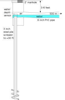
One such instrument, a water-pipe tiltmeter, consists of a 1/3-mile-long buried pipe containing water
whose depth at each end is measured to one millionth of an inch. To completely
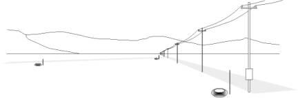
measure the tilt of the ground two pipes are installed at right-angles, usually
along the edge of a field or track.
A sealed 6" PVC pipe is buried at a depth 3-6 feet and half-filled with water to emulate an underground lake. Tilts of the ground are measured relative to this horizontal watersurface. To reduce sensitivity to ground motions caused by rainfall and snow loads the sensors are attached to buried helical piles driven like corkscrews 30 feet underground. The battery-powered water level sensors are accessed via a 2 foot manhole cover. Once installed, the tiltmeter requires little maintenance. Data are transmitted to a nearby computer via radio links every few seconds, and the computer forwards the data to analysis centers in Ellensburg WA and Boulder, Colorado.
Five of these new tiltmeters will be installed initially in the Puget sound region monitoring earthquake activity tens of miles underground. Data from the tiltmeters will be used to learn how increments in stress eventually lead to large earthquakes.
For further information contact Prof. Tim
Melbourne (tim@geology.cwu.edu) or Prof Meghan Miller (meghan@cwu.edu) at CWU
Ellensburg, or Prof. Roger Bilham at CU Boulder (bilham@Colorado.edu)