Dalbandin
Tuesday, January 18, 2011 at 20:23:26 UTC, 28.838 deg. N, 63.947 deg E
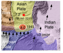
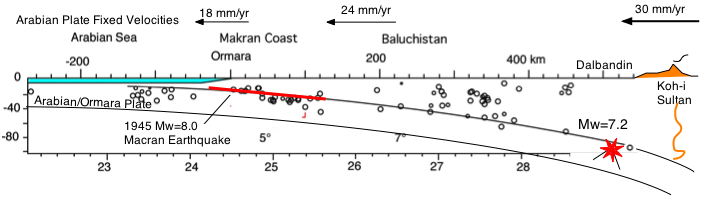
The earthquake occurred at 1:30 in the morning local time in the descending Arabian plate south of the volcanic arc at a depth of ~80 km. It was followed by a Mw 4.6 aftershock in the over-riding Asian plate (≈60 km depth). The volcanoes to the north, which demarcate the border between Afghanistan and Baluchistan, are dormant but microearthquakes are common in their vicinity. At the latitude of southern Baluchistan the northward velocity pf the Arabian plate beneath the EuroAsian Plate is roughly 30 mm/yr. In the section below GPS data are from Triggnet: well-located depth solutions from Engdhal et al. (1998). Click on section for large view.
Mechanism
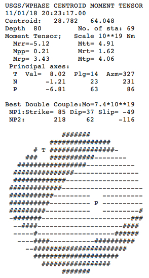
The earthquake ruptured a normal fault, that most likely fractured through the upper part of the descending Arabian plate where it is flexed downward by the over-riding Asian plate. It occurred 300 km north of the great 1945 Mw=8.0 earthquake, and about the same distance west of the Quetta 1935 Mw=7.6 earthquake. Since the 1945 earthquake the Arabian plate has shifted roughly 2 m northward beneath the Asian plate. USGS 19 Jan focal mechanism is reproduced below. Centroid coordinates below are less precise than the hypocenter calculation although that to is subject to some uncertainty.
References
Breitzman L.L., R. W Nirnie and G. D. Johnston, Fission track ages of the Chagai Intrusive Baluchistan, Pakistan,GSA Bulletin; February 1983; 94(2); p. 253-258
Engdahl, E.R., and A. Villasenor, Global Seismicity: 1900-1999, in W.H.K. Lee, H. Kanamori, P.C. Jennings, and C. Kisslinger (editors), International Handbook of Earthquake and Engineering Seismology, Part A, Chapter 41, pp. 665-690, Academic Press, 2002.
Engdahl, E.R., R. van der Hilst, and R. Buland, Global teleseismic earthquake relocation with improved travel times and procedures for depth determination, Bull. Seism. Soc. Am. 88, 722-743, 1998
Khan, M. A. R. Bendick, I.M. Bhat, R. Bilham, D.M. Kakar. S. F. Khan, S. H. Lodi, M. S. Qazi, B. Singh, W. Szeliga amd A. Wahab, Preliminary geodetic constraints on plate boundary deformation on the western edge of the Indian Plate from TriGGNnet, J. Himalayan Earth Sciences, 41 (2008), 71-87). Published 2010
Khan, M.A., Siddiqui, R.H. and Jan, M.Q., 2010, Temporal evolution of Cretaceous to Pleistocene magmatism in the Chagai Arc, Balochistan, Pakistan, in Leech, M.L., and others, eds., Proceedings for the 25th Himalaya-Karakoram-Tibet Workshop: U.S. Geological Survey, Open-File Report 2010-1099, 2 p. [http://pubs.usgs.gov/of/2010/1099/khan/].