Awaran (Baluchistan) Earthquake 24 Sept 2013 11:29:48 UTC, Local time 4:29 pm. Updated 30 Sept 2013
POWERPOINT SLIDES FOR CLASS USE
Mw=7.7, Lat 27.00 deg N Long 65.514 deg East, depth 20 km (USGS) Deathtoll 559 (estimated 700) as of 30 Sept See Field relief report
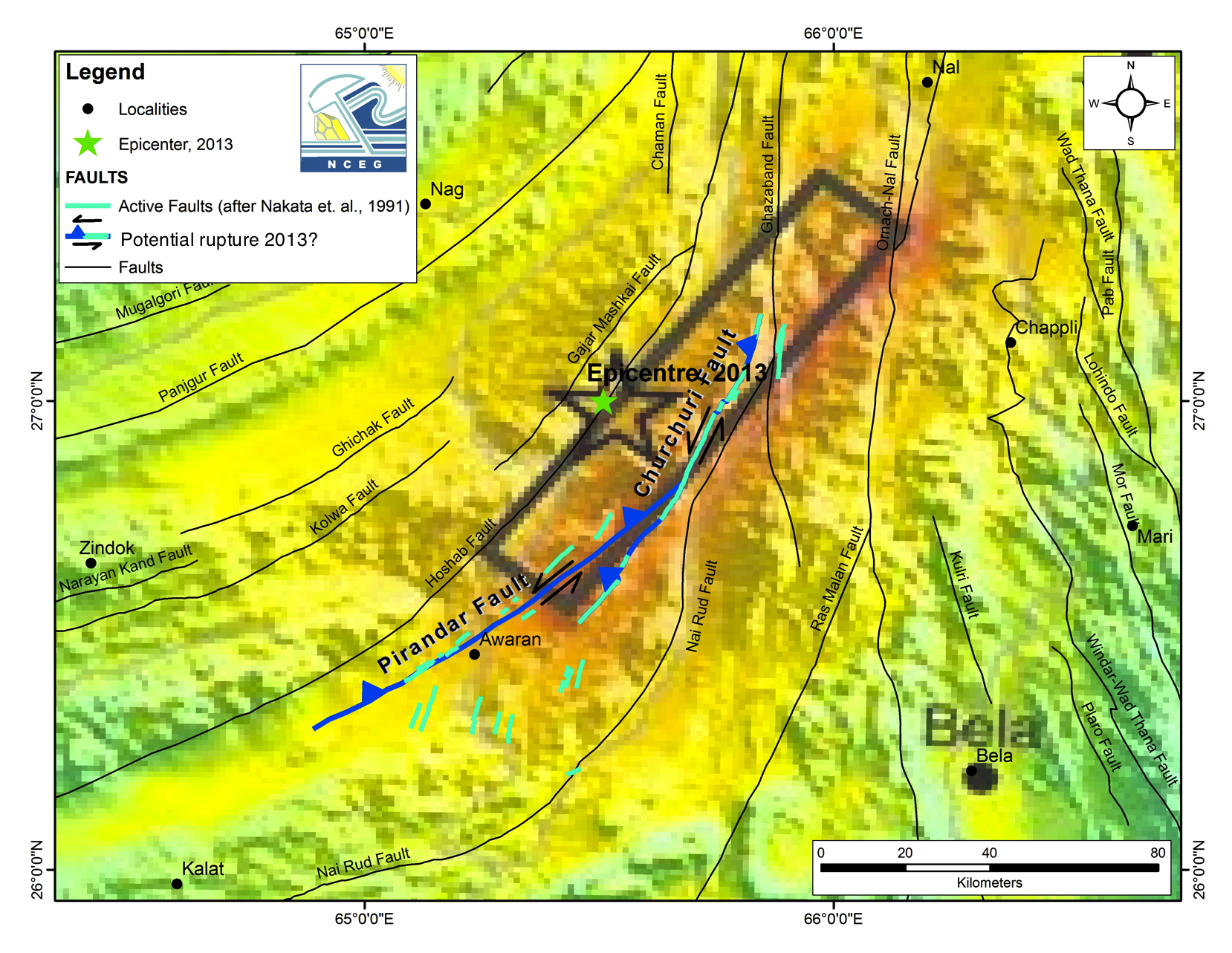
The earthquake occurred on the eastern edge of a southward facing promontory of the EuroAsian plate in a broad zone of deforming mountains bordering the western edge of the Indian plate. Its mechanism was dominently strike-slip with a thrust component, consistent with local fold and fault axes in the region. The fault that slipped is possibly the Hoshab fault (Hoshab Geological map) or the nearby Pirandar/Churchuri fault system (NCEG active fault map (from Asif Khan & Waqaz Javed, Peshawar).
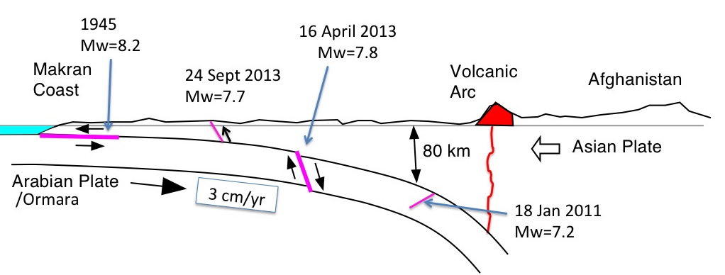
In January 2011 a lower crustal Mw=7.2 earthquake occurred near Dalbandin 200 km to the NW. In April 2013 a Mw=7.7 earthquake at 83 km depth near Khash, Iran, caused considerable damage in western Baluchistan. Although the focal mechanisms of the three earthquakes differ, they have one feature in common - they all occur in the collision zone between the northward descending Arabian plate and the EuroAsian plate.
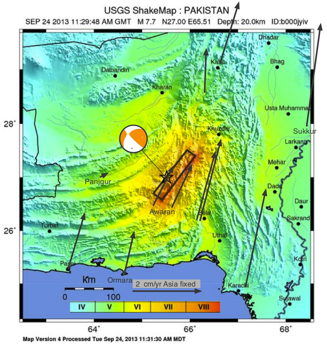
The map below shows local GPS velocity vectors superimposed on the 24 Sept USGS synthetic shake map. The northward velocity of the Indian plate (east of the Chaman fault system Bilham et al., 2007) is approximately 30 mm/yr measured by continuous GPS receivers at Karachi and Sukkur (Khan et al., 2008: Szeliga et al., 2012)
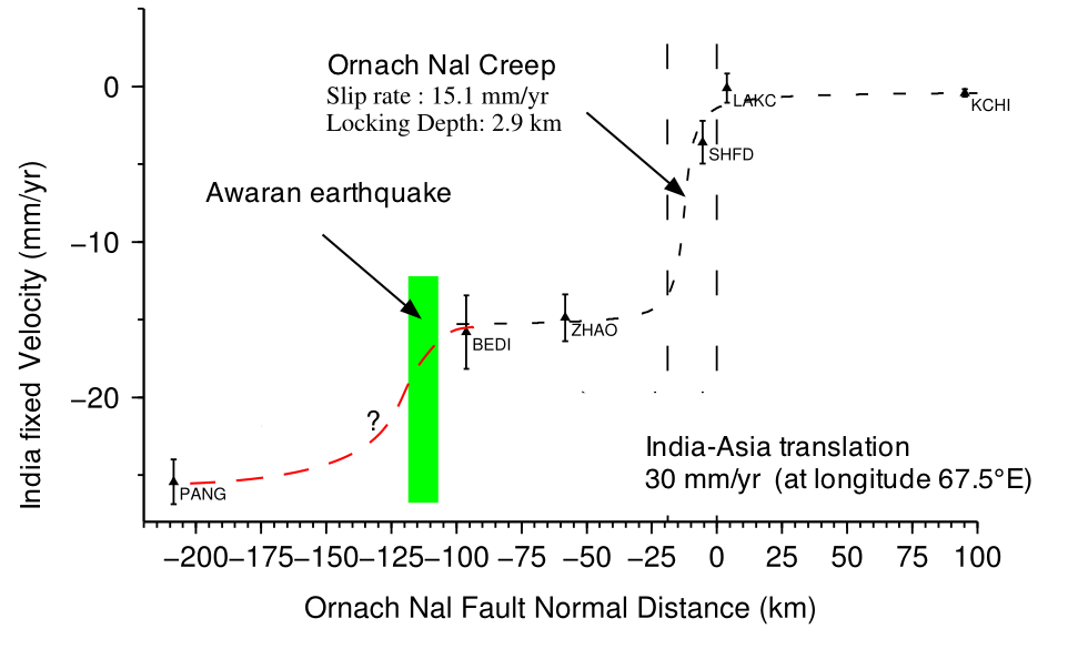
GPS velocities measured in a CU collaboration with Pakistani scientists in the past 7 years indicate that points near Awaran move at roughly 10 mm/year relative to Panjgur, 100 km to the west (Szeliga et al., 2012). Assuming a mean slip of 6 m (see USGS slip vs distance plot below), earthquakes on the causal fault could recur at intervals of 600 years. However, it is probable that the plate boundary here is partitioned between several curved faults (Panjgur, Hoshab and Nal Rud) that sequentially share the burden of plate convergence.
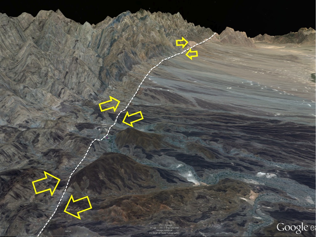
Google image above shows a 30 km section of the northern half of the fault. The south-to-north cartoon below illustrates schematically the relationship between the three damaging Mw>7 earthquakes that have occurred in Baluchistan since 2011. The Arabian/Ormara plate has slipped roughly 2 m northward since the great Makran earthquake of 1945 and there have been no intervening Mw=7 earthquakes. The collision rate is roughly 50% faster than the Himalayan collision.
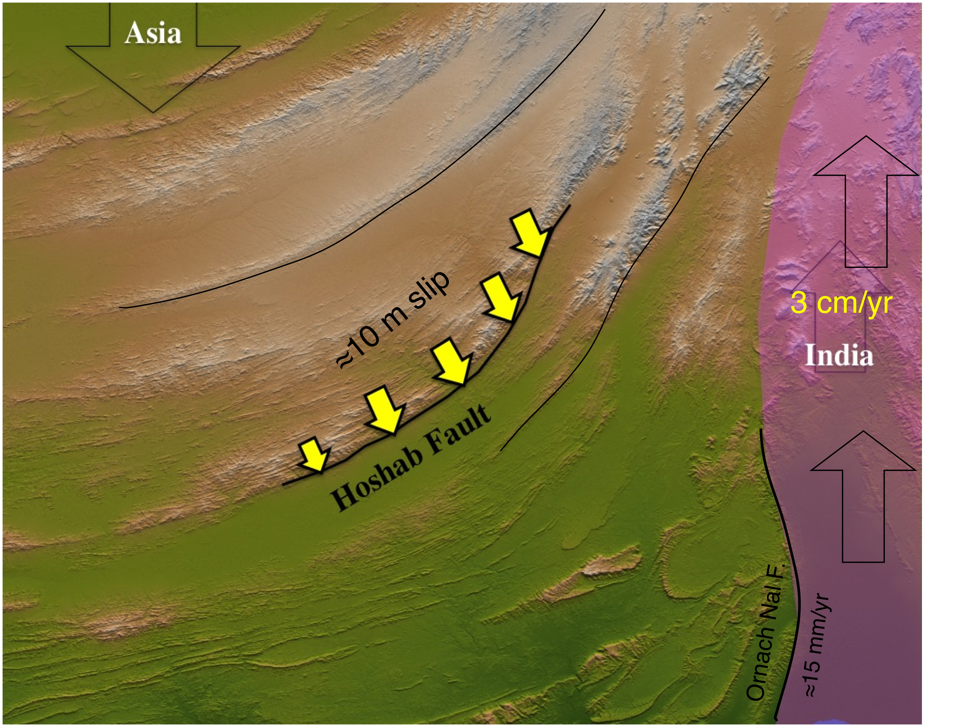
The figure below illustrates our current understanding of the velocity field from west to east (Panjgur to Karachi). The question mark indicates the unconstrained pre-seismic velocity field west of Awaran. The southernmost Ornach Nal fault near Bela is considered to be creeping quite close to the surface at 15 mm/yr (Szeliga et al., 2012)
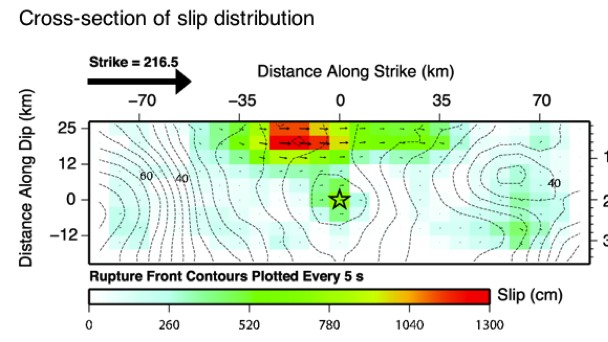
The USGS slip v. distance solution for the earthquake (version 1 Gavin Hayes) shows that the central 70 km the Hoshab fault slipped approximately 5-6 m in about 30 s with localized slip in the central 20 km exceeding 12 m. The Hoshab fault is mapped as a thrust with numerous splays and it is probable that a more complex model including several fault splays may be required to characterize slip in the earthquake.
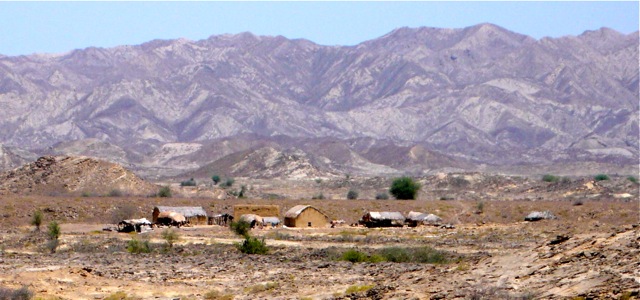
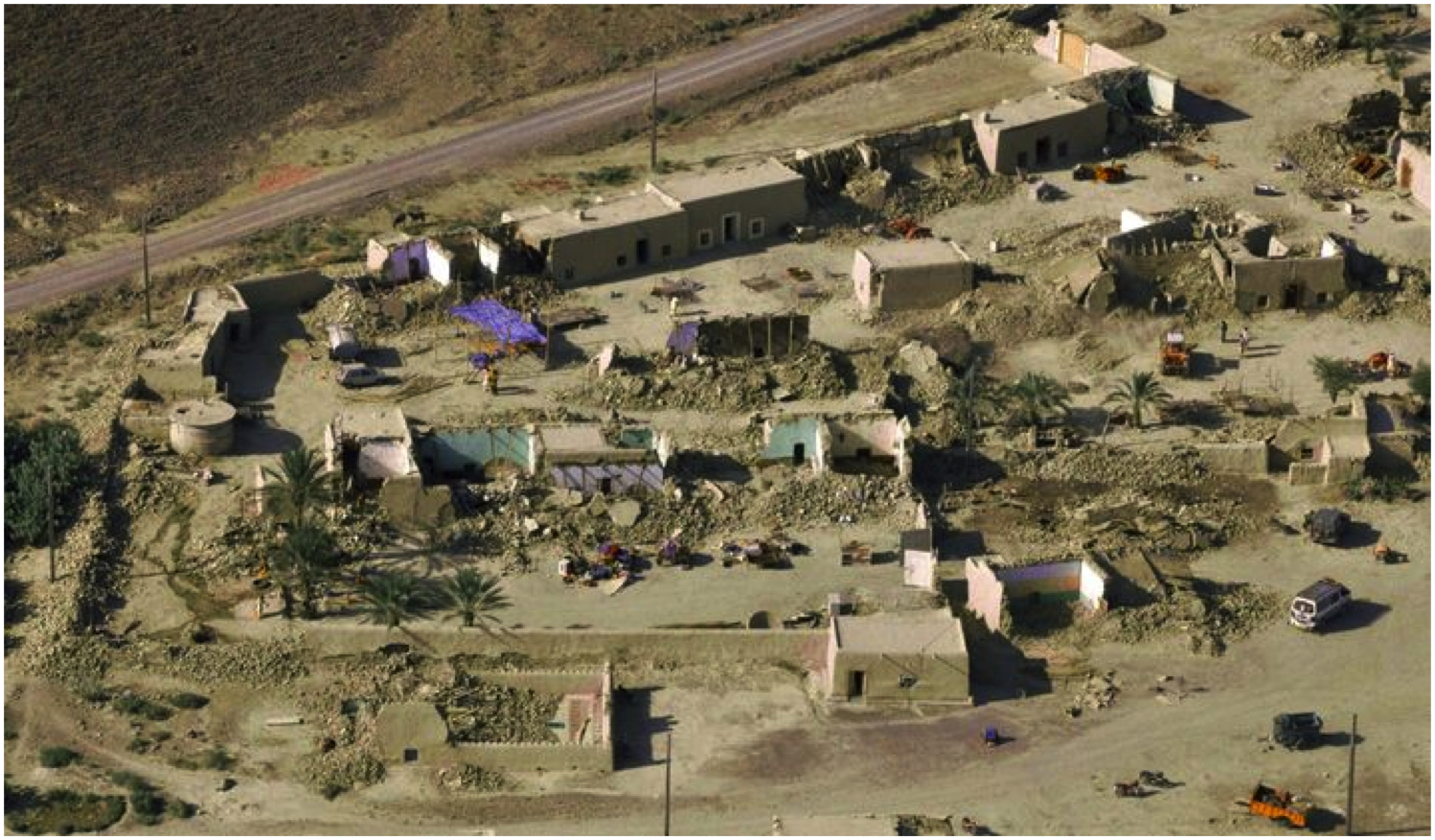
The region near Awaran is arid and sparsely populated, but because adobe house construction is common, especially in the villages near the epicenter, the initial death toll grew by about 200/day (515 on 28 Sept ) as rescue missions reportd epedcentral damage. 30% of the houses in Awaran are reported to have been damaged. The photo of a hamlet near Awaran below was taken in June 2008.
Below- view from the air showing 70% collapse of adobe structures in a walled compound near Awaran. Click to enlarge.
On 26 Sept the Pakistan National Disaster Management Authority estimated 21,000 dwellings had collapsed with a deathtoll of 355.
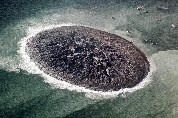
Shaking in the earthquake de-stabilized offshore mud volcanoes that commonly form temporary islands along the Makran coast. A new island formed 24 Sept, and additional islands were noted 25 Sept in approximately the locations of islands that emerged following the 1945 earthquake. Dimensions of the first of these islands are estimated as 200 m diameter and 10 m above sea level.
The offshore mud volcanoes arise from a similar mechanism that drives the numerous mud volcanoes inland along the Makran coast. See clathrate refutation. A few of these rise to several hundred meters but their eruptions (also triggered by earthquakes) tend to be less prolific than implied by the substantial volumes needed to form offshore islands. The volume of the new islands must exceed 1,000,000 cubic meters if they lie in water depths exceeding 40 m. The several islands that have formed all follow the crest of an inferred offshore anticline and show the same shear planes and wave like structure as islands that formed in 1945.
Compare the remarkable shear strength of the mud in the above photo taken 2 days after the Sept 2013 earthquake with its slip planes and rough boulders, with the air view of the Ormara west Bay west island in 1945 showing similar features.. Sondhi (1947) shows close up views of the shear planes taken during his visit to Gwadar Island 1945.
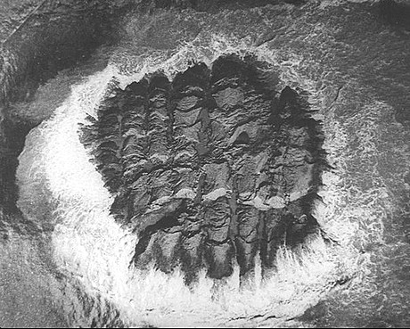
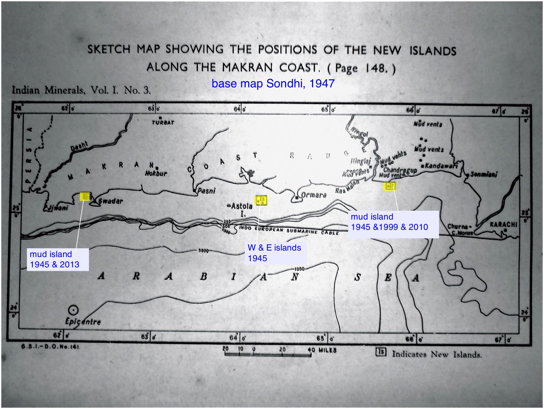
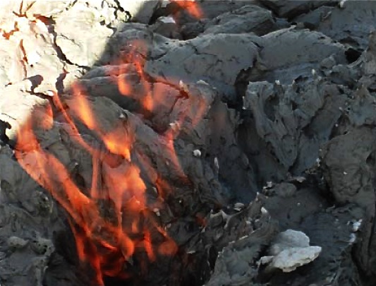
New islands (image above from Sondhi, 1947-(click for enlarged views) were first recognised in 1945 accompanying the Mw=8.2 Makran earthquake, but they also occur spontaneously, as occurred in 1999 (Malan Island; Delisle,2004) and 7 Nov 2010 when Sapt Island (below) was created . Soon after its formation Sapt Island measured about 200 m x 30 m and rose about 7 m above sea level with ten circular vents erupting dark wet mud and methane. The methane does not spontaneously combust, and requires independent ignition (below). The 1945 observation by villagers in Ormara that "the sea caught fire" may have been an observation of methane ignited by lightning.
References
Bilham, R. S. Lodi, S. Hough, S. Bukhary, Abid Murtaza Khan, and S.F.A. Rafeeqi, (2007) Seismic Hazard in Karachi, Pakistan: Uncertain Past, Uncertain Future, Seism. Res. Lett. 78(6), 601-631.
Deslisle, G., 2004, The mud volcanoes of Pakistan, Environmental Geology 46:1024–1029
Delisle, G., U. von Rad ́ H. Andruleit C.H. von Danielś A.R. Tabrez A. Inam, (2002) Active mud volcanoes on- and offshore eastern Makran, Pakistan, Int J Earth Sciences, Geol Rundsch, 9, 93-110
D.M. Kakar, (2013) Preliminary report on the birth of newly emerged Island and the nearby Chandragupta Mud Volcano, District Lasbella, Balochistan, Pakistan, University of Quetta.
Khan, M. A. R. Bendick, I.M. Bhat, R. Bilham, D.M. Kakar. S. F. Khan, S. H. Lodi, M. S. Qazi, B. Singh, W. Szeliga amd A. Wahab, (2008) Preliminary geodetic constraints on plate boundary deformation on the western edge of the Indian Plate from TriGGNnet, J. Himalayan Earth Sciences, 41 (2008), 71-87).
Martin S.S. and D. M. Kakar (2012), The 19 January 2011 Mw 7.2 Dalbandin Earthquake, Balochistan, Bull. Seism. Soc. Amer., 102(4), 1810-1819.
Szeliga, W., R. Bilham, D. M. Kakar, and S. H. Lodi (2012), Interseismic strain accumulation along the western boundary of the Indian subcontinent, J. Geophys. Res., 117, B08404, doi:10.1029/2011JB008822.