Burnes, A., (1828) A Memoir and Supplementary Memoir of a map of the Eastern Branch of the Indus. Fol., Bombay. (The original document is listed by T.H. D. LaTouche on page 73 of his 1917 Bibliography of Indian Geology and Physical Geography, Geol. Surv. India, Calcutta pp 571. The number of pages of the original folio and its location, are not given, but it is probable that the ms. lies in the Asiatic Society of Bengal and was borrowed and transcribed at Oldham's request in 1924, by Alexander Heron, who was then Director of the Geological Survey of India.
The following is transcribed from a typescript copy of Burnes (1828) with an explanatory handwritten note from R.D. Oldham (1924) deposited by Oldham in 1924
in the Archive of the Geological
Society of London
The typescript copy consists of four
parts: an explanatory handwritten
note (in italics below) from R.D. Oldham, a 28 page manuscript dated March 1827
including a 6 page preamble, a supplementary manuscript completed in August 1828 (pages
29-65) with a 5 page postscript, and a map of the Rann of Kachchh dated Bombay April
1828 (pdf please acknowledge the Geological Society of London archive LDGSL 767 if you use this copy). The March 1827 and August 1828
accounts give information on the Allah Bund, and changes in the Rann to its
south not found in Burnes' Travels into Bockara Part III. Highlighted items in red below are references to the Allah Bund, Fort Sindri and to the nulla termed
"Kaera" which was a branch of the Puran (Phuraun) river just north of
the entrance of the Allah Bund. The
significance of this nulla and the old dam labelled across it SW of Vigakot, is
that its existence implies minor topography near here prior to the 1819
earthquake.
For readers who wish to avoid reading Burnes' general (and verbose) observations in the Kachchh region, the 1819 earthquake items are extracted in a Summary pdf here. and in an abbreviated .html view here.
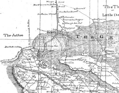
The simplified map redrawn by
Oldham in his 1926 account (1926pdf )
is dated March 1827, whereas the map accompanying Oldham's 1924 transcript here
is dated April 1828 (1828pdf). A view of the
NW corner this is shown below. Burnes' quote is from Horace.
Burnes (1828) Memoir
R.D.
Oldham
A Memoir and Supplementary
Memoir of a Map of the eastern Branch of the Indus giving an account of the
alterations in it from the bursting of the dams in 1826,
and the changes brought about thereby in the Runn of
Cutch, with a theory of the Runn's formation, proofs of its having been once a
navigable sea, etc. and some remarks on the route of Alexander the Great.
by
Lieutenant Burnes,
Deputy Asst. Qr. Mr. General in Cutch
Lambit
Hydaspes
Presented by Command of the Governor in Council
to the Literary Society of Bombay
Camp at Lucput
28 March 1827
13 August 1828
Gov. Lith. Press. Bombay
Memoir
Cutch
is a country so peculiarly situated with an inconstant stream like the
Indus in the West, the Runn on the North and East, and a receding sea on the South
that it is ever likely to undergo alterations and besides, it has lately become
subject to earthquakes and been visited by famine; but the object I have in
view in drawing up the present memoir has not been so much to explain the
alterations throughout, as to point out the changes of the Eastern branch of
the Indus, and the country bordering on it, from the bursting of one of the
bunds of the Indus, or of one of the Punjab rivers, in last November, and
which has already produced so great an alteration that the whole face of nature
near Lucput may now be changed.
The
disadvantages which Cutch labours under are not altogether natural but
have originated from the jealousy of a neighbouring power which has been
evinced in a most cruel degree by depriving it of the freshwater of the Indus
and thereby destroying a large tract of irrigated land, and converting a
productive rice country into a
sandy desert.
The
Raos of Cutch had at no distant period three tannas in the dominions of Sind
viz., Ballyaree, Raoma Ka Bazar and Budeena, their right to which was indisputed. The year 1762
gave however a new era to both nations and it was the beginning of a calamitous
one for Cutch. Ghoolam Shah Kalora, after bringing an army of eighty thousand
men into Cutch, and meeting with a warm reception above the small village of
Jarra, returned full of vengeance to Sind, and threw a bund across the Phurram
River at Mora, which although it did not entirely prevent the water of the
Indus passing to Lucput, so impeded the progress of the main stream that all
agriculture depending on irrigation from it ceased. Since then the successors of the Kaloras, and even the
reigning dynasty of Talpor, by name Ali Moradi, put a finishing blow by
throwing up the bund of Ali Bunder
about 25 years ago. Previous to this latter circumstance the water at Lucput became rather fresh
for four months annually, that is during the swell in the Indus, and there was
even a "wand" or shepherds settlement, at Chungasir near Syra, but since the battle of Jharra all attempts at
cultivating rice in the lower part of this branch of the Indus have been
fruitless, for the little fresh water which did come down was merely a scanty supply which either forced itself
over, or through the different bunds.
Cutch
having thus been deprived against all the laws of nations. of the advantages of
a River which contributed so much towards the support of its people used no
exertions to regain what nature had granted it, and while in this state of
apathy and indifference the earthquake of l819 threw up a natural mound
five miles above Sindree, called
by the natives "ullah bund" or the "bund of God" (in
allusion to its not being the work of men) which actually dried up the channel
between Ali Bunder and it, a distance of nearly fourteen miles, so that
all communication between the Phurraum River and the sea was thus stopped.
The
original injuries inflicted by the Kaloras had so completely destroyed this
part of Cutch that such a wonderful event excited but little remark. This earthquake also overthrew the
"tanna" of Sindree on
the banks of the river and surrounded it by water, blocking up at the same time
the road to Sind from Cutch which passed it, and rendered it a convenient place
to collect customs. The Rao's
Government made a feeble attempt to establish a collector of Revenue on the
newly raised bund, but although it was within their own boundaries and the Amirs of Sind did not refuse
permission, still Meer Tharra, or rather his son, a subordinate chieftain,
opposed it as would have diminished his revenue. The loss of this Tanna was
regarded as a misfortune from the loss of revenue to the state, but the people
in 1819 were not aware that at so early
period as 1826 the circumstances should prove more destructive than all
the bunds both natural and artificial had ever been thrown up by their most
bitter enemies.
The
country about Sindree although it had lately yielded not a blade of vegetation
was dry and hard for half the year, and the road to it was open for commercial
purposes equally long. The
shortness of the route made it the frequented one into Cutch, but the
earthquake, while it raised the Ullah Bund, must have lowered it near Sindree
which was immediately overflowed from the sea and continues so to this day, the
water extending sixteen miles to each side of it. The place is now abandoned since then and it is only
now marked by the ruins of a small brick fort. The earthquake, however, although it was the immediate, was
certainly not the primary cause of this event as will be hereafter shewn.
Previous
to the battle of Jharra in 1762 the Eastern branch of the Indus or Phurraun
emptied itself into the sea by passing Lucput and Kotasir, and the country on its banks participated of the
advantages which this River bestowed
throughout its course. Its annual inundations watered the soil and
afforded the Natives of Cutch a plentiful supply of rice to the whole country
between Sindree and Lucput, then known by the name of "Sayra" being
cultivated; and so fertile was it that it yielded an annual revenue to the Government
of from seven to eight lacs of corries,
upwards of two lacs of Rupees. The bunds thrown across deprived it of
this advantage and the channel which had been before deep and navigable became
now quite shallow and filled with mud there being no running stream to carry it
off. So much indeed was this the case that before 1819 bullocks and even carts
could cross at Lucput without much inconvenience, and the stream was so narrowed that a
part of the bed became the beaten foot path of the inhabitants from Lucput
to Sindri.
It
is more than probable that if the water had been allowed to flow no alteration
would have taken place at Sindree as the channel of the River near it would
have been quite deep enough to contain any influx from the ocean. Not so after
Ullah bund had been thrown up for the water thus excluded from its usual
channel, and rushing with the
greatest violence from the sea overwhelmed the neighbourhood of Sindree with
salt water which has ever since continued. The inundation of November 1826
has burst every bund in this branch of the Indus, and cut through the Ullah
Bund itself but although the cause of the original evil has been thus removed,
its effects have remained and there is little chance of their soon being
obliterated.
The
river from Lucput to Sindree become much deeper within these few months and
with the exception of one place "Sundo", where it is two miles
broad, varies from two to three
fathoms deep. At Sindree is nearly
three, and on Ullah Bund itself it is very little less. At the former place
(Sindree) the water is drinkable and at the latter quite good while the
beneficial effects are not felt so low as Lucput, except at the lowest tides,
which would favour an inference that the column of water is not great enough to
make any impression on a creek which is daily affected by the tides and had
already overflowed its banks for many miles with salt water.
The
conclusion then must be that until the Phurraun River disembogues a sufficient
quantity of fresh water to dislodge the salt about Sindree, there can be little
prospect of the people of Cutch regaining their fertile pergunna of
"Sayra" but, even allowing such a circumstances to take place, and
judging from the lowness of the country, I have very many doubts if much
advantage would be derived from such an influx of fresh water, for water (when
beyond a certain quantity) whether salt, or fresh, is hostile to the
purposes of agriculture, and there is no reason to believe that, as the present
tract continues flooded with salt, it should become dry, with fresh water.
Further the banks of the Phurraun although they never, from the nature of the
country, could have been very high, have once been overflown and the strong southwesterly winds which blow so
violently would mix a quantity of salt water with the fresh, for the velocity
of the River (allowing it to run at all times) would be greatly diminished by
the supply of water which it would require to impart to the immense sheet
of water below Ullah bund. It is needless to urge that the floods in the Indus
and the South Westerly winds prevail at the same time and that the one is
equally strong as the other, for the wind is much more powerful; but surely it
does not require much of it to impede the progress of a stream which has very
low banks and which are in many places under water.
The
floods in the Indus commence in April from the melting of the snow in the
mountains of Himalaya, and an opportunity will be early afforded of discovering
how far the above is correct. It must always be kept in recollection that the
overflow of salt water near Sindree originated, not either from winds or rain,
but from an earthquake, which I have every reason to believe rather lowered the
tract than forced an influx of water from the sea.
While
we discuss the chances against Cutch regaining its former wealth we must not
omit to mention the probability of a very considerable change taking place. The
many different mouths of the Indus would appear to be sufficient for the egress
of its waters but the bursting of the bunds in the most paltry branch shows
that they have a tendency to escape by Lucput, and this the more remarkable as
this passage has been shut against them for a period of sixty five years,
during a part of which there has actually been no water in its channel.
The
period too at which this unexpected circumstance took place was unusual. and
having thus regained its passage to the ocean it will have the full advantage
of this ensuing swell to open the bunds and deepen its channel. I am not aware
of the breadth of the channel at Ullah bund previous to 1819 but it is at
present only 120 feet, and this, with only a depth of 15 feet, is not
calculated to bring about any great alteration but its having been once opened
gives hope of further change.
If
the late influx could change the water from salt to fresh at Sindree and even
make its effects felt so low as Lucput, every hope is to be entertained for the
body of salt water which it passed through extended for a distance of fifty
three miles. i.e. from Ullah bund to Lucput, and it had tides (certainly not
strong ones) also to contend with. The
result of one or two inundations for as many years is likely to bring
about an increase of depth to the channel of the River, and were this secured,
the sheet of water about Sindree could drained and adapted to its former
purposes. I do not consider the
late overflow as any proof to the contrary for it only points out that the
quantity of salt so much predominated over the fresh that no material
alteration has been produced , but is this at all remarkable when we consider
the influence the sea has been allowed to have for years past over the tract?
The
continued alterations of the Indus ought not to produce feelings of
despair on the part of Cutch, and, as there is a distant hope of restoring the
country to what it was in the Reign of Rao Lucput, no exertion should be
wanting. The Ameers of Sind acknowledge the right of
the Cutch Government to a nulla called "Kaeera", which is above Ullah bund, and the place where they
collected taxes to the very day of the earthquake in 1819 [Note: It is a singular fact that the
boat belonging to the Tanna at Sindree was left dry in this nulla the day after
the earthquake and, from their being no water to float it out, has been broken
up and sold]. No delay therefore should be made in again possessing
themselves of the place, as it may very materially contribute to the interest
of their country and will give them full possession of the grand natural Bund,
by far the most formidable in the river,
The
various reports of the natives on the alterations which the earthquake had
brought about in the northwest frontier of Cutch, both as regards the River and
the Runn, first induced me to turn my attention to this part of the country ,
and
it
may be of importance at a future period to know the state I found it in March
1827. and I shall therefore, for the sake of perspicacity, describe it under
the different heads of 1st.
"The Indus" and 2nd
"The Runn".
The Indus
[Page 6 of the GSI London transcription]
The rivers in a country subject to periodical rains,
necessarily undergo many alterations, chiefly from the greater velocity and
quantity of the waters at different seasons of the year. This has been the case
in a most striking manner with regard to the delta of the Indus, so much so,
that neither a harbour nor the course of any particular branch, can be
depended on for a longer period than a season. The eastern mouth of it had been
so much altered both by natural and artificia1 means that it had even lost the
name of the parent stream, and was known, on one side of Ali Bunder by the
designation of Koree, while it was called Phurraun on the other, but the Koree for
25 years past could no longer be termed a River, and was only a creek of the
Sea affected by the tides. The bursting of the Alor bund has, however, changed
the face of things, and the waters of the Indus once more wash the North West
shores of Cutch.
The water at Lucput is not yet fresh except at the lowest tides, but a
reference to the map will point out that there is nothing remarkable in such a circumstance,
when the extent of salt water which it passes through is considered. Moreover,
the tide affects the stream as high up as Ibrahim Shah Peer, though it does not rise many inches, and the country
on both banks is a salt marshy desert likely to impart its predominating
quality to the waters which pass over it. The classic name of Indus sounds
pleasing to the ear, but no beauty whatever must be looked for on its eastern
branch. The greater influx of fresh water will no doubt make considerable
alterations, but at present there is not a single object on its banks to rest
the eye on except a dreary desert.
It would be needless to enter into any proofs of the Koree having been previous to the battle of Jharra the most
eastern channel of the Indus, as it is a notorious fact in the history of
Cutch, has been remarked on by every writer concerning Sind, and the country,
as it is at present opposes no obstacle to our belief of the fact but on the
contrary favours it very materially. Ghoolam Shah's bund and those which were
thrown up after it, were then the only cause of the change, and by 1819
previous to the earthquake almost all appearance of the channel of the Indus
had disappeared, and, from having been a navigable stream, the smallest
flat-bottomed boats could with difficulty reach Sindree, and below Ali Bunder
it had actually become dry. While things were in this state the earthquake of 1819
occurred and threw up Ullah Bund
five miles above Sindree so that
every chance of the channel between it and Ali Bunder being again filled with
water was removed by an artificial barrier on the North and a natural one on
the South. The impulse given to the waters in the Koree creek by this concussion
of nature was great and as the water of the sea could not find entrance into
the former channel of the river it spread on all sides near Sindree and brought
the country to its present state, whereby commerce has been greatly impeded.
This last bund tho' it appeared more formidable than all that had preceded it,
has been like them overwhelmed by the late inundation and there is again an open
passage between the Lucput River and the main stream of the Indus.
The
distance from Lucput to Ullah bund
is by water upwards of fifty miles, though it is much less in a straight line. The river is, at the narrowest part about 100 yards wide and at
the widest, which is Sundo about two miles;
opposite Lucput it is nor more than 250
yards and at Ullah Bund it is only 40
yards. Its depth varies from two
to three fathoms of water in all places except Sundo where it is only two feet
at low, and three, at high tide. Its banks throughout are low and muddy
and above the Misree Peer (which
is about ten miles from Lucput) intersected by numerous nullahs some of which
are from six to eight feet deep. The two principal ones are Kotro on the South
side and Chungasir on the North, both within two miles of each other and
remarkable as being close to what formerly was a ford across this branch of the
Indus.
Sundo
extends up and down the River for a distance of two miles and lies a little
higher up than Chungasir. The River is here about two miles broad,
that is the channel, for the water expands on both directions and the appearance
is no longer that of a River, but of a sea and instead of nullas to impede the
approach to the banks we have a sheet of water on both sides about half a foot
deep, covering a clayey soil and extending many miles both to the East and
West. The earthquake is also said to have made this alteration as it was
before it equally deep and no wider than other parts of the River. Two miles
farther up there is a celebrated Peers place on the West bank of the River
called Ibrahim Shah Peer, and hold
in much veneration by the Sailors.
It consists merely of a few bricks and bamboos with flags, but it is
particularly useful as it serves to point to the entrance to the Meetra "nar"
a channel leading to a landing place called Dingro, six coss from whence goods are conveyed to the small
village of Pallia five coss off.
This channel is navigable and I met five boats in one morning sailing up
it. It is as deep as the main
stream. Here it is quite
impossible to imagine being in a river as there is nothing but a wide expanse
of water on all sides. At a distance to the Eastward and elevated a little
above the horizon the hills of the Puchum Island may be distinguished and those at Nurra in Cutch are distinctly visible. Lucput is also in sight.
 The ancient Tannah of the Raos of Sindree which is
only 12 or 13 miles distant from the Peer is not visible from it though it
comes into sight a few miles beyond.
The ancient Tannah of the Raos of Sindree which is
only 12 or 13 miles distant from the Peer is not visible from it though it
comes into sight a few miles beyond.
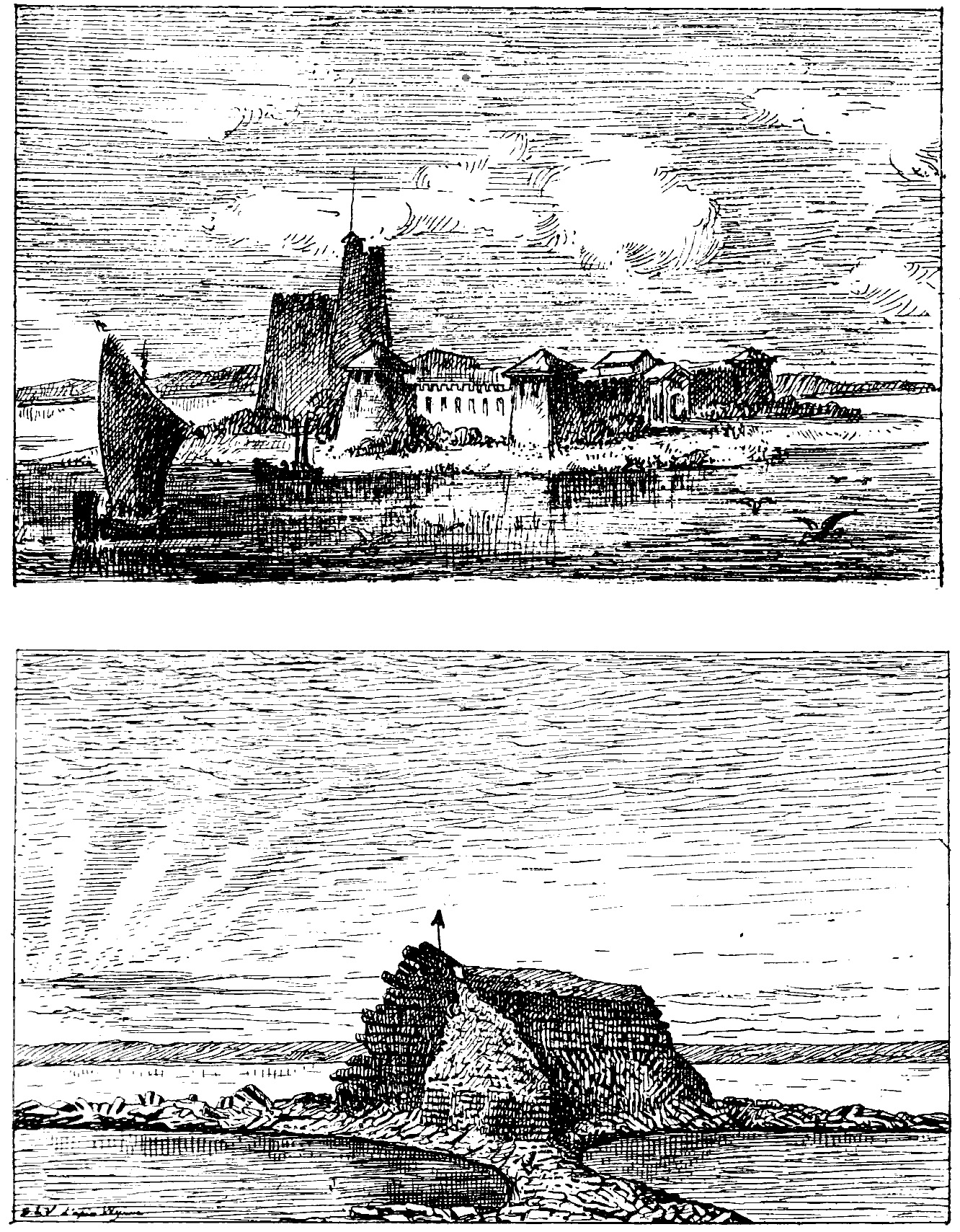
The two figures of Fort Sindri are
reproduced from the posthumous book by Montessus de Ballore (1924) who
redrafted them from earlier materials. The upper figure is from Grindlay's
painting of Fort Sindri omitting foreground materials but including the
ficticious skyline hills. It shows
the square masted boats that were unable to tack on the river. The lower figure is from Wynne' s
memoir on Cutch. An elevated
perpective is chosen to illustrate the distant Allah Bund.
Sindree is situated on the Eastern Bank of the river and is a ruined
fort of 150 feet square with four towers and built of burnt bricks. Three of the towers had fallen down and
the only one now standing (and it is in a precarious way) is the northwestern
on which there is a flag staff.
The walls have been two feet thick but this is impossible to say how
now. The tower that stands is
about 18 feet high and is near the gateway which was on the west side. There is not a vestige of a house
remaining and the interior of the fort has become a tank and is filled with
salt water, in which there are fish. The only dry spot near the place is where
the walls actually stand and which is kept so by the bricks being piled on one
another. The river runs close under its
walls and it must have been a very valuable position for the government to
collect its taxes when the road between it and Cutch, as well as Sind, was
open.
A
black speck on the horizon to the northeast at about a distance of 5 miles,
points out the position of Ullah Bund,
the embankment thrown up by nature in the earthquake of 1819, previous to which
period there was not a single trace of it. It runs due
East and West and is said to extend twelve miles eastward and about two
westward. It is about 10 feet above the level of the River which is at present
from 12-15 feet deep and; is composed of soft clay and covered all over with
shells and has quite the appearance of having been broken through by some
torrent. At present the opening is only from 30-40 yards wide but there are
marks of the current having extended during the swell some 200-300 yards to the
Westward, while the Eastern side now presents a bank of ten perpendicular feet
and looks as if it had been cut by manual labour. The bed of the River is the
same as the banks, clay, and the whole soil around appears to be a mixture of
it and sand.
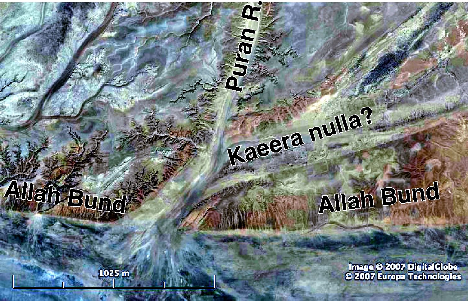
This 2007 GoogleEarth Image of the Allah Bund shows an abandoned
nulla trending ENE from the 250-m-wide entrance of the Puran (Phurraun) river.
Could this be the Kaeera Nulla where the custom's boat was left stranded in
1819? The Puran narrows to <40 m some 60 m from the southern edge of the
Bund. The Puran channel is now
choked with sediment and the western bank rises less than 2 m above the channel.
A short distance
above bund is Kaera nulla, a
position where the Cutch Government collected taxes before the earthquake and
the extremity of their territory on the North. The merchandise was crossed over
it in small boats and the beasts of burden that carried it to the nulla, swam
across and, being again laden, proceeded to Sindree. At this (from the dry land
on both sides of it) the stream again resumes the appearance of a river and
though narrow is quite navigable even at this late season of the year (March).
I here met several boats coming down from Wunga so that there can be no doubt of the fact that all the bunds in this branch are broken down. There is no village at the place and the Sind government have their tanna at Raoma Ka bazaar, a small place five miles from the river, and twelve from the bund. I shall not venture tom give further account of the River to the northward as it has not to come under my personal observation. Be it sufficient to remark that the walls of Omercote are said to have been partially thrown down by the bursting of the Aror bund, and some reports have even gone so far to say that the water made its escape into the Runn near Parkur, by passing though the Nueyer country, but this, I hope to determine at no distant period.
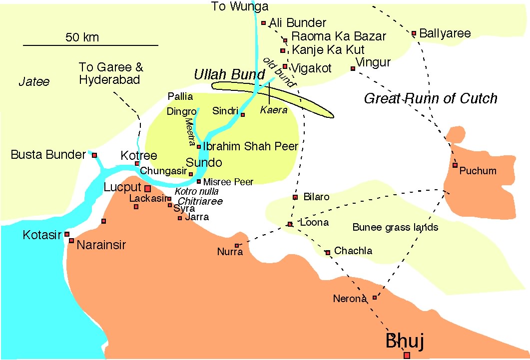 A simplified version of Burnes April
1828 map showing the Allah Bund concave south, with a nulla named Kaera in
which the customs officials docked their boat. The boat was left high and dry in the earthquake and had to
be dismantled. Lake Sindri shown as yellow; rock as brown.
A simplified version of Burnes April
1828 map showing the Allah Bund concave south, with a nulla named Kaera in
which the customs officials docked their boat. The boat was left high and dry in the earthquake and had to
be dismantled. Lake Sindri shown as yellow; rock as brown.
Having
described the appearance above Lucput we shall now mention the part below
it. At Lucput it runs northwest for six miles to a place called Kotree where although there is no drinking water there is a
halting place and it is the high
road to and from Sind, for all merchandise (there being a good Camel road to Garee and Hyderabad) is now brought by this route and the
horses which come from Khorasan and Candahar annually are crossed over from
this place, indeed all the supplies, excepting those that pass by the Runn
routes, are transported to and from Kotree. The reason is obvious viz. that it can be crossed at all times
of the tide and boats of two hundred candies can be used instead of the flat
bottomed ones of 15 and 20 that ply above Lucput. Eight miles farther to the
westward, on the west of a small creek, lies Busta Bunder a small fort in ruins and celebrated
as being the harbour at no distant period where all merchandise was
landed. It, like Kotree, is
ill-supplied with water and, being at a greater distance from Lucput than that
place, and having become a subject of dispute between Cutch and Sind, and even
of open warfare, it has been abandoned.
The fort has been nearly thrown down and Kotree answers all the purposes
of it. It had also the
disadvantage if being up a creek while Kotree is on the bank of the river.
At a distance of about 15 miles south of Busta Bander
on the Cutch side lies the bunder of Kotasir which boats of four hundred and even five hundred
Candies can approach. They ship their cargoes into smaller boats and send them
up to Lucput. The landing place at
it is very much exposed but large boats can come close enough to be left dry at
low water. The Koree is about five miles broad at Kotasir but a little below it
loses all appearance of a River.
This
state of things presents a very different aspect from the time in which Captain
Wilson visited the Indus
in 1820, but it becomes a duty in justice to the officer to state what appears
to have brought about this change. At the time the earthquake happened the
Koree, from four miles below Lucput
to a short distance higher up than Chungasir, contained only one foot of water at
low tides and varied from two to three at high. but since then the channel has
continued to deepen annually and Captain Wilson's ford at Chungasir (to which I
was directed by the very guide he himself had employed) I found to be covered by
fifteen feet water at low tide,
and, instead of being five hundred yards wide was only three hundred feet.
Had
the Ullah bund never come into existence the alteration would likely never have
taken place for the water in the Koree had ever since the erection of Ali Bunder
bund begun to recede, though it had not entirely left the channel. The
earthquake happening at the time the strong South West winds blew up the water
towards Sindree. and as it met with a resistance from Ullah bund which it never
before experienced, it would naturally deepen the channel through which it
passed and finding no egress, lodge some way near the bund which it did. The
introduction of such a body of water as had logged at Sindree kept the
communication between Lucput and Sindree open to the tide when the South
Westerly winds had subsided for the North West winds have never since 1819. been
able to dry up the Runn at Sindree and thus the present state of things has been gradually brought
about.
It is, however necessary to state that this great
alteration has not taken glace from the late overflow of the Indus, as I have
it from undoubted authority that the River was as deep at Chungaseer three years ago as it is now, and it is therefore to
be looked on as the effect of the earthquake, though it occurred three years
after.
I proceeded with a copy of Captain Wilson's
reconnaissance to examine the ford at Chungaseer. I started from Syra at about 8A.M. and found the Runn to commence at one
full mile from the village. I proceeded
on expecting to fall in with the nulla of Kotro, but my progress was arrested
four miles from the edge of the Runn before I reached it, by one formed about
three years ago, ago. and called by the natives "Chitriaree". It is about twenty feet wide and three deep at
low water with banks and bed of clay it but is affected by the tides. It runs
into the Koree close to the Misree Peer. From this nulla, I could see Kotro which is about 500 yards farther on, but on
encountering so formidable a barrier as this first nulla I deemed it useless to
prosecute my enquiries any further by land more particularly since my guide
(who is a fisherman and frequents the place daily) told me that Kotro had five
feet of water in it at low tide. These difficulties are however not the only
ones to be encountered on the approach to Chungaseer for at two miles from the edge of the Runn the tides
overflow the road, and I was several times in danger and compelled to dismount
and walk through the water and mud, so that the road which is only a footpath
for fishermen could never be adapted to military purposes, were there no river to cross.
On
reaching the Misree Peer by boat
from Lucput, I found the breadth of the channel to be two 260 feet and
that at Chungaseer as before mentioned 300 feet. At both places the depth
varied from 12-15 feet. The nulla of Kotro I found to contain the (5 feet) depth which my guide had
represented. I looked in vain for the bushes of Chungaseer, and found the name
applied to two nullas deeper than Kotro running through a soil so clayey that it
was with difficulty the boatmen could drag the boat along it. A reference to
the map will point out that the existence of such a ford would now be of no use
as the tract to the North is covered with water, but the nature of the country
is such that, even were there no water, no advantage ever could be taken or it
by an invading army for besides there being no pasture nor cattle there is no fresh
water, and it is too near the delta of the Indus ever to be sufficiently
consistent even to bear infantry. Myannas and fishermen, synonymous terms by the by, who are a sort
of Amphibious beings, pass daily
between Syra and Chungaseer, but
it is quite a matter of indifference to them whether they swim the nullas of
Chitriaree and Kotro or even the main stream. So little do they think of this
mode of life that a fisherman's hut is actually built between the Koree and
Kotro, and if the water overflows it (which it sometimes does) the native sites
upon the roof till it subsides , or swims across it till he reaches dry land.
and this life he leads both during the rains and dry season. There is another
circumstance which, though trifling greatly deserves remark in this route. I mean
that mosquitoes on the Runn which are so numerous that it is impossible almost
to breathe without swallowing them and which although they do not bite, so
torment the horses that it is with difficulty they can be forced on. These
insects continue throughout the year and are numerous beyond all conception.
They appear to live upon the salt encrusted on the sand and are always found
where the soil is a little muddy.
The greatest proof of the
wonderful alteration which the river had undergone is the
difference of its breadth from the time when Captain Wilson visited it. He mentions its breadth at the fishing place
of Bitaree to be
only thirty yards, whereas it is now much wider than Chungaseer and its depth
at four fathoms, when it is now only two.
That the river has been generally deepened is quite
beyond doubt, for even after the earthquake, boats of more than fifty Candies
could not reach Lucput Bunder and it is not unusual now to see two hundred
Candy boats sailing up the River. The Natives even assert that it had become so
shallow in 1818 that bullocks, carts and camels used to cross it at low tides,
and that there was a road to Sind directly across from the bunder, nor did the
earthquake immediately deepen it, and it was not till 2 or 3 years after that it
was navigable for so large vessels.
The
craft which is and always has been used up the River to Pallia, Sindree etc.,
consists of flat bottomed boats called Doondee which are square rigged, with one mast, and carry
from twenty to thirty candies. They
can only go before the wind, and so little idea have the people of tacking that
the boat in which I went up was dragged down from Ullah bund to Lucput through
the shallow water by manual labour and when the water became too deep it was
impelled on by oars and bamboos. On getting so low as Ibrahim Shah Peer the
boatmen went on shore and tracked the Doondee along the bank, but the operation
was so tedious that we did not reach the bunder for fifty four hours, a strong Southwesterly wind being
against us.
By far the most frequented part of the River above
Lucput is the Meetra naar leading
to the landing place ten miles from Pallia, and were there any great alteration to take place in the depth of it,
it would be more frequented than Kotree for there is not much more trouble in conveying
goods once shipped thirty, as well
as ten miles. w. The traffic between the Thurr [the tract of the country from
the Indus eastward to Ballyree and
towards Parkur is so called] and Lucput by the River has existed for so very
few months that it is difficult to tell how it is likely to turn out.
About twenty five boats have passed up and down, since the bunds have burst, laden
with rice and ghee. All the exports however go to Kotree as I believe there is
some objection on account of this being the place where the Rao collects his
taxes, through the hands of the farmer who pays two lacs and thirty thousand carries,
annually for the bunder.
I met several Natives who had sailed for a considerable
distance up this river, and one who had been twenty four miles beyond Wunga, thus passing through several of the bunds but as
there are only ten or twelve boats on the whole of this branch it is not likely
under present circumstances to supersede Kotree.
The
Koree produces abundance of fish, and of very different sorts, some of which are
remarkably good. Since the late inundation fresh water fish have been caught
in great abundance. Porpoises even are found above Lucput. The birds, however, that frequent
it are beyond all description numerous. There are flamingos, cranes, ducks,
gulls etc. with a long list of others the names of which I never heard and many
of which 1 never saw before. The most singular of the whole is a bird something
larger than a goose with an immense yellow coloured beak called by the
Natives "Paynee", a Pelikan I believe, which is a favorite food with
the Lohanns, the prevailing caste in Sind.
The Runn
In describing this tract of Runn near the Kotree, in elucidation of what has
been advanced in the preceding pages, there is a wide field for remark, as it
is beyond a doubt that this tract was, at no distant period, cultivated which
must ever remain dubious with regard to the other parts at least as far as I
have been able to discover.
The cultivated
part of it was known by the name of "Sayra" which is indeed the modern title but it is no
longer the productive pergunna which it was. It included the country
between Lucput, Syra and Moondan
and extended a few miles North of Sindree, but did not cross the River in any
place. The whole of it was a soil of the most productive description, and while
it is said to have yielded a better sort of rice than is produced anywhere else
on the banks of the Indus, it enriched the inhabitants of Cutch by three
successive crops annually viz. rice, barley and chara ( a sort of moong). But
this was not the only advantage derivable from the river for although it did
not admit of cultivation lower down than Lucput or as far East as Loona, still it fertilized the soil so much that the pasture all about
the latter place and even as low down as Narainseer was very favourable for rearing cattle, and large
herds were kept in the neighbourhood, on that account. Nor were the Outchees
confined at this time within their own narrow limits, for they had also sway
over part of the province province of Jattee, on the western side of the River for a considerable way up. There was even at a very late period ie. 20 years ago, the remains of an extensive "wand" at Chungaseer and the natives still point out the site
of a village on Sundo which they pretend to know by the remains of some trees.
These advantages perished through the revengeful
disposition of Meea Ghoolam Shah Kalora after the battle of Jharra, and so dependent
was the country on the River that its productiveness ceased the very year the
first bund was thrown up, and there was never enough fresh water to raise the most trifling crop
after 1762.
The state which the river was in previous to the
earthquake of 1819 prepared the surrounding country for the change which it has
since undergone. The water which overflowed the country at Sindree came
immediately from the West, but a reference to the Map will shew that this is
not impossible, though it must have come first from the South.
A very
few hours brought it to its present depth. and thus the road, which, by its
shortness served to expedite the arrival of grain into the country, and in a
degree compensated for the loss of Sayra, was rendered useless and impassable
for both men and animals, and in this state has it continued to the present
date March 1827.
Nurra,
the town first approached in Cutch by the Sindree route lies thirty two miles
from it and the water now covers the twenty Northern miles leaving only a dry
tract of twelve. This is, however, only the state to which it has relapsed
for two months after the
earthquake of 1819 it had attained such a height from the mass of water, that
the guns of Sindree were conveyed by boat from that place to Nurra or rather
within two miles of it. It was four or five [feet?] and the Natives had hoped
that a free navigation would have assisted them when the road had been
overflowed, but this only continued for a season and the late swell in the
Indus has left it in statu quo without
any increase whatsoever. Some pools of water have been left between Jarra and
Moondar while the tract between Syra and the Indus has been left comparatively
dry, but this will be easily accounted for as the river, instead of turning due
north as in most of our maps, runs in some degree parallel with Cutch, and the
water would overflow the river due opposite Nurra or Moonda sooner than
opposite Syra, and it is, therefore, not a difficult matter to solve why the
water between the Nurra and Sindree was so deep after the earthquake.
If,
however, the different overflows to which the River is subject sooner
flood the country about Nurra and Jarra, that between Syra and Chungaseer is subject to the tides which pass over it far 3 miles south of the
river a circumstance which renders the road to what was formerly the ford both
dangerous and difficult. Those alterations have now reduced the Cutch people to
the necessity of following a more circuitous route by Loona to Raoma Ka bazaar. Loona is situated in the Bunnee, or grass lands, ten
miles ENE of Nurra but the more usual road to it from Bhooj, is by Nerona to
Chachla.
This
road however has undergone some trifling alteration and has become more
circuitous that it formerly was from the Sindree water extending so far to
eastward. It like all roads across
the Runn, is shut up from April or May to October. The traffic across it is very considerable though the
distance from Raoma Ka Bazar when
at Loona even is forty eight miles
across a Runn without a drop of fresh water.
The
natives even say that the tide crosses this road but this is evidently a
mistake as it is hardly felt at Ibrahim Shah Peer. They mistake the force of the southwesterly winds for tides
as they really, by their force, impel the water up. Indeed a very intelligent
man at Syra in describing to me the circumstances of the filling of the Runn
said "the more wind the more water", which so completely corresponds with what I have seen that I hold
it to be a fact.
It must
not be imagined that, because the country about Sindree is under water, it is at
all navigable, for it is in most places not a foot deep. Local rain, as may be supposed, has a
very considerable effect on such a tract, as from its being already saturated
with water, every drop that falls adds very considerably to its depth.
The
Wand of Loona is very extensive as may be seen from the accompanying statement.
Loona on the Bunee
total 250 people, 80 cutcha wells, & 1 shop. The Rao is the named proprietor
|
Castes |
Houses |
M |
F |
boys |
girls |
Bullocks |
cows |
buffaloes |
Horses |
Asses |
Camels |
Goats |
|
Lohannu |
1 |
1 |
|
|
|
|
|
|
|
|
|
sheep |
|
Megwar |
2 |
5 |
3 |
2 |
2 |
|
|
|
|
|
|
|
|
Jet |
30 |
40 |
35 |
20 |
10 |
30 |
400 |
600 |
10 |
|
|
350 |
|
Loonye |
16 |
16 |
16 |
10 |
7 |
|
|
|
|
4 |
|
80 |
|
Suma |
28 |
28 |
28 |
10 |
5 |
40 |
450 |
|
|
8 |
|
|
|
Hindoos |
3 |
6 |
3 |
2 |
2 |
|
|
|
|
|
|
|
|
Mussalman |
74 |
96 |
79 |
40 |
22 |
70 |
850 |
680 |
12 |
12 |
10 |
430 |
|
Total |
77 |
102 |
82 |
42 |
24 |
70 |
850 |
680 |
12 |
12 |
10 |
430 |
Remarks: the tank only contains rain water. Ten of the
wells are drinkable but they are merely dug in the sand and fall in
annually. The inhabitants evacuate
the place during the monsoon. The produce of ghee varies from two to four
maunds daily according to the season. The vicinity yields firewood though the
forage is very indifferent. The road to Nerona is impassable from June to November for carts though foot
passenger go all the year. There are 29 soldiers of the Rao's and ten of the
Poona Auxiliary Horse stationed at this place it being the high road into Sind
and a good lookout position.
It
seems to be a matter of doubt whether the Ameers of Sind have it in
contemplation to throw up the bunds in the Phurraun once more. Their feelings at
present on the subject are said to be dread of a similar inundation, and when it
is mentioned that the late overflow, so far from injuring them, has actually
produced a crop in places where grain was never before cultivated, and thus
quadrupled the crop of 1827 they may feel no immediate inducement, as
there will be no object to gain. This fortunate occurrence was accidental for
the column of water was so great that had it met with very great resistance
from the bunds it must have been attended with consequences similar to those
that sometimes happen in the low countries of Europe. But it is beyond a doubt
that the irrigated lands which formerly produced so much will not now yield an
equal quantity without these bunds, for, however much a river' running through a
country may fertilize it, still it stands to reason that it must be more
productive when that country is intersected by canals and dams are thrown up to
extend the water.
While I am thus enlarging upon the advantages likely to
accrue to Cutch in a commercial point of view from the late bursting of the dams,
I beg distinctly to point out that the river in its present state, is but ill adapted
for military operations and indeed the approach to the country of the Ameers
from Cutch to be more difficult than ever, for we
could formerly have transported. our Artillery across the bunds,, and thus
saved the trouble and expense of a large pontoon train, for I never could believe
judging from the character of the Sind nation that they would be enlightened enough,
of their own accord, to throw down bunds which had been the result of so many
years' labour.
I
only mean to impress on the mind the alteration to which the river is subject
and which I have great hopes will at no distant period lead to its being particularly
useful both in a military and commercial point of view.
The town of Lucput which has a bunder on
the banks of the river is well known as a large mercantile place. It lies upwards
of a mile and a half from the Koree from which it is separated by a low tract flooded
in high tide. The fort
was built not
 many years back by Futtih Mahommed who
took eight years in completing it. It is the largest in Cutch being two and half
miles in circumference. The position is its greatest advantage and the ruins of
a very ancient city, called Wagum Chaora Ka Gud, about six miles east of it, proves that the
former rulers of the country were not ignorant of this.
many years back by Futtih Mahommed who
took eight years in completing it. It is the largest in Cutch being two and half
miles in circumference. The position is its greatest advantage and the ruins of
a very ancient city, called Wagum Chaora Ka Gud, about six miles east of it, proves that the
former rulers of the country were not ignorant of this.
The town is built entirely within the walls and there is sufficient vacant
space to admit of the population being doubled or even trebled, but this is not
likely to occur as the only people who would take up their residence would be
merchants (for there is no agriculture in the neighbourhood) and there is
already a population of 5839 souls who are either of that description, or
others who administer to their wants. The walls of the town are well built
though in some places rather low.
Both the gateways are unfinished and so is the ditch. Although it could
not stand against our system of
 warfare it would be a very formidable barrier to a
native army.
warfare it would be a very formidable barrier to a
native army.
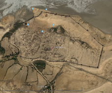
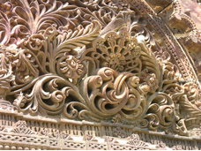
The GoogleMap view of the 18th century fort and a view of its 3
m high northern gate in 2007. The
village inside its walls was damaged slightly by the 2001 Bhuj earthquake, but
the elegant stone carving on the Hatkeshwar temple survived.
 I must not omit to mention the great difficulties
which I have had to encounter in drawing up this short memoir from the
singularly vague and confused names which make their appearance in our maps. I
have enquired in vain for the branch
of the Indus called Loonee and have not even been able to fall in with a native who knew its
name. The Goonnee alone is known to them and the Phurraun is said to be a
branch of it, and the Loonee must either have crept into our maps from an idea
that the river of that name which passes through the Jhoodpoor territory to the
Parkur Runn, flowed into tho sea at Lucput, or the Lucput creek, from its vicinity
to the extensive wand of that name [Loona?] on the Bunee, must have received the
appellation of Loonee, from some of our travellers.
I must not omit to mention the great difficulties
which I have had to encounter in drawing up this short memoir from the
singularly vague and confused names which make their appearance in our maps. I
have enquired in vain for the branch
of the Indus called Loonee and have not even been able to fall in with a native who knew its
name. The Goonnee alone is known to them and the Phurraun is said to be a
branch of it, and the Loonee must either have crept into our maps from an idea
that the river of that name which passes through the Jhoodpoor territory to the
Parkur Runn, flowed into tho sea at Lucput, or the Lucput creek, from its vicinity
to the extensive wand of that name [Loona?] on the Bunee, must have received the
appellation of Loonee, from some of our travellers.
Signed: Alexander Burnes Dept.
Asst. Qr. Mr. Genl. in Cutch.
Camp at Lucput 20th Mrch 1827
-------------------------------------------
The
supplement was written after recess in the winter of 1827/8 during which Burnes
prepared several maps of Kachchh.
His supplement is dated Lucput 13 August 1828 (pages 29-65) and has a 5 page appendix on
Alexander's route.