Locations of Creepmeters

Three creepmeters operate across the southernmost San Andreas Fault on Durmid Hill over a total distance of 6.95 km.

The distance between Ferrum (coFE) and Salt Creek (coSC) is 1.37 km, and between Salt Creek and Durmid (coDU map) is 5.58 km.

Discussion

Creep on the southernmost San Andreas in this period of time is the same at all three sites - roughly 1.2 mm, consistent with the 2 mm/year that has been recorded for the past several years here.

At coDU the slip is roughly linear, accelerated 20% by shaking in the Mw6.9 event and terminated by softening of the surface muds after heavy rain. The second earthquake occurs in the period of time when the surface fault is weakened by moisture, and no slip is observed (less than 10 microns).

At coFE and coSC 80% of the creep occurs during the two triggered slip events, with possibly 10% caused by steady creep, and an additional 10% occurring at the time of precipitation.

A 50 micron triggered slip event occurred simultaneously on the Superstion Hills fault.

Hypothesis

We conjecture that softening of the surface fault following heavy rain decouples the surface soils from underlying fault-zone shear. That is, the surface may be briefly converted to a viscous fluid. During this time no creep displacements are imprinted in the surface layers. Creep offsets are resumed when the clays revert to their dry solid condition. If true, the slip amplitude of paleoseismically recorded earthquakes may be underestimated in transiently saturated surface muds. Sag ponds and peat deposits are a favoured location for paleoseismic trenching.

Dextral slip vs fault expansion

The three creepmeters are installed obliquely to the fault with the assumption that slip is purely strike-slip. An experiment is underway to determine whether the width of the fault zone varies during creep events, and whether local rainfall causes expansion of the fault gouge, or differential expansion of the fault flanks. Sensors are arranged to monitor soil moisture, fault and flank expansion with a 3 m +3 m aperture and a resolution of 10 microns.


Triggered Slip Durmid Hill

August 2009 -January 2010

click here for Slip triggered by the Baja 4 April Mw=7.2 earthquake

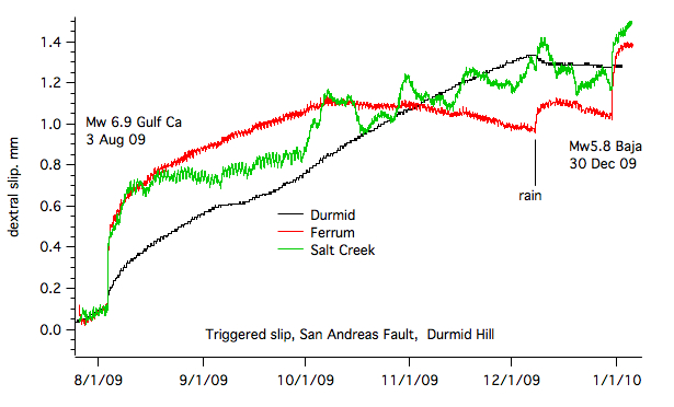
Two earthquakes resulted in an incremental offset of the surface San Andreas fault in 2009. The slip events were superficial and, unlike the spontaneous slip events of previous years, were not observed on the nearby laser strainmeters on Durmid Hill. The Mw6.9 Gulf of California earthquake on 3 August 2009 resulted in 0.7 mm of slip, and a M5.8 earthquake in Baja California on 30 Dec 2009 resulted 0.4 mm of slip. Background creep on the fault at all three locations during the period August 2009 to January 2010 amounted to 1.2mm-1.4 mm. The data have been partly corrected for thermoelastic effects, which are small on the graphite rods, but significant on the stainless steel instrument at Salt Creek. pdf

3 Aug 2009

Slip on the fault was impulsive at all three creepmeters and decayed with an initial time constant of roughly 2 hours. Amplitudes were similar at Salt Creek and Ferrum but were reduced by an order of magnitude on the southernmost site on the crest of the Hill south of Bat Cave Buttes. pdf
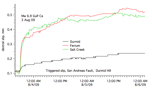
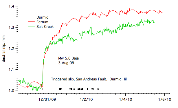
30 Dec 2009

Slip on the fault was was impulsive at Salt Creek and Ferrum decaying with an initial time constant of roughly 2 hours. No synchronous slip occurred at the southernmost site on the crest of the Hill south of Bat Cave Buttes.pdf
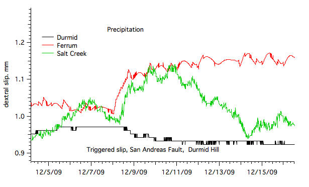
Precipitation

Rain moistened the surface of the hill starting 8 December 2009. Runoff was considerable and ponding in the fault zone (mud cracks visible in early January) was observed near the crest of the Hill. The effects of the rain (which propagated southwards) were to facilitate additional slip of 0.1 mm at Ferrum and Salt Creek, and to cause apparent left lateral slip of 0.05 mm at Durmid followed by zero slip on the fault for the following month.pdf