REFUTATION of Rajendran et al's two articles on the imaginary Brahamaputra fault.
Bilham and England (2001) processed four sets of geodetic data and concluded that the 1897 earthquake beneath the Shillong Plateau was caused by 15 m of reverse slip on a 110 km long, south-dipping reverse fault, 9-35 km below the surface. Concerned for the absence of surface faulting Rajendran et al. (2004) proposed a fault near the Brahamputra river. Bilham (2006) protested this absurd location for active faulting, but in a rebuttal Rajendran et al. 2006 present further spurious arguments. Their proposals are not supported by the data they cite, and published data are distorted to fit their claims. In conrast numerical data that refute their claims are dismissed without quantitative justification. They cite scientific publications out of context, and in some cases incorrectly. Rajendran et al'.s errors are addressed below.
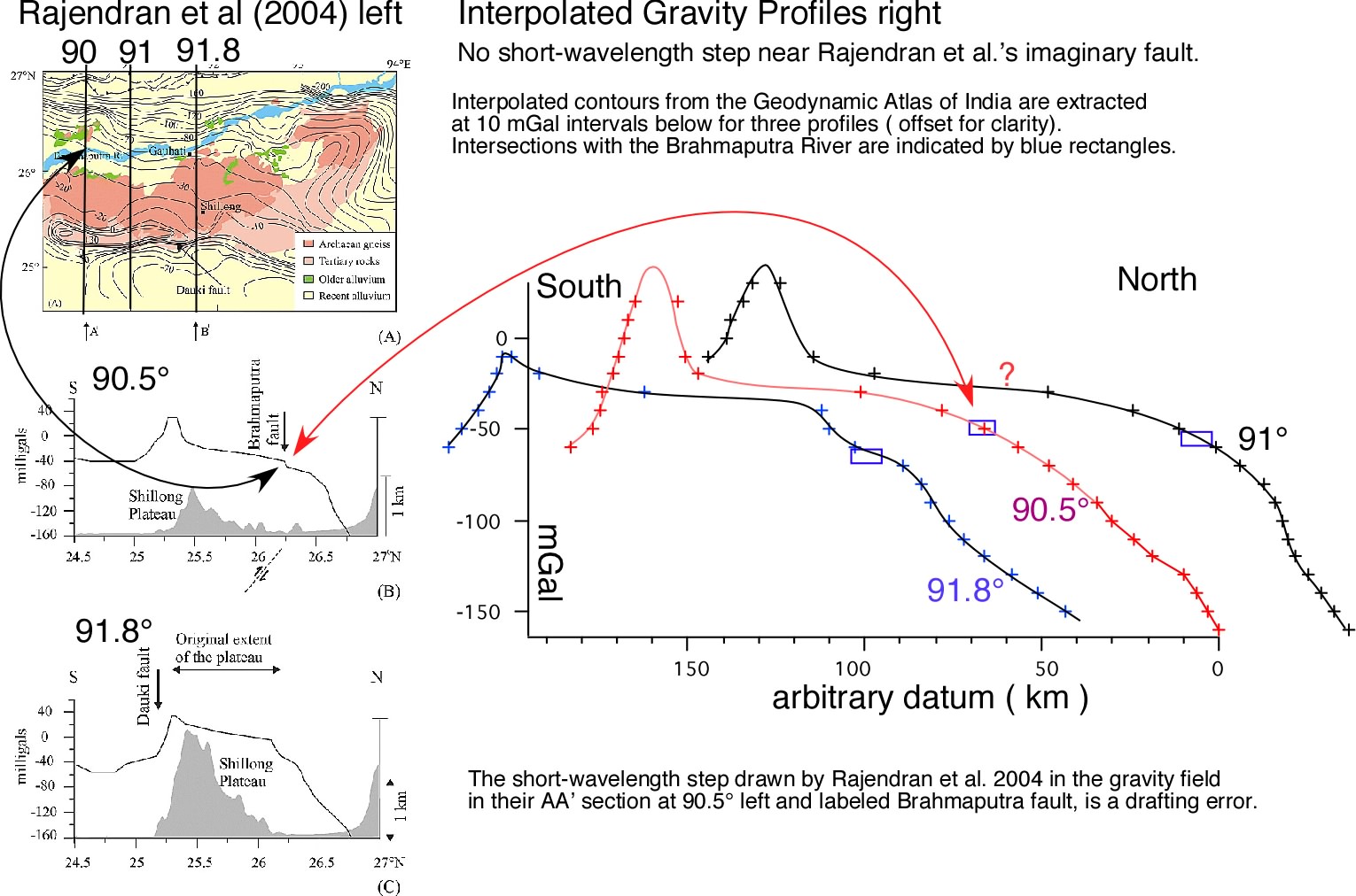
1.They introduce a drafting error in gravity data and label it "Brahmaputra fault" (see data).
2. They do not calculate the morphological consequences of faulting ( a large lake north of the Brahmaputra and high ground south of the river) (see models) .
3. They do not examine the geodetic data, but dismiss it with the phrase "of doubful accuracy". Yet the geodetic signal is 3-10 larger than the noise and has exemplary spatial coherence.
4. They agree with Bilham and England (2001) that no surface faulting occurred near the surface projection of the Oldham reverse fault, but then propose that faulting should have occurred, a proposition that we and they are naturally unable to support.
Extracts from Rajendran et al 2006 left, discussion right (in red). Section 1 is omitted.
Rajendran et al (2006)
|
commentary
|
|---|---|
[2] The model of Bilham and England [2001] is based on two sets of triangulation data of doubtful accuracy.
|
Four sets of data are involved, each with precisely known observational errors. These original observations and their corrections are described triangle by triangle in Walker 1882, Strahan 1891, Bond, 1899 and Wilson 1939). The accuracy of each angle measurement is 3-10 µrad, verified by triangle closures based on the average of ten observations. The accuracy of each group of three angles is verified by misclosure after spherical excess adjustment. These angular errors correspond to displacement uncertainties of 20-50 cm in 10-25 km line lengths (including post-seismic misclosure errors). In contrast, displacements observed in 1897 were ten times larger. Damage to the subsurface marks of control points is recorded for only 5 of the 35 points used.
|
The 1898 trigonometrical survey south of the hypothetical Oldham fault, across the Shillong Plateau, failed to meet the triangle closure standards of the Survey of India [Oldham, 1899].
|
The reason for triangular misclosure is attributed to afterslip beneath the plateau during the meaurements. This can be inferred not only from the 3 years of observed aftershocks (Oldham, 1900; 1903;1904), but from warping of the surface, evidence for which is recorded by Oldham (1899, see below). This may have substantially increased coseismic slip, but it clearly had no effect on shallowing the depth of active slip, since the geodetic solution constrains cumulative slip to be deeper than 9 km. Oldham (1899) reports that vertical displacements were so large that they could be observed (and in one location quantified) without instruments. A very readable contextual discussion of this evidence can be found in Wood (1911). The continuing deformation of the triangles on the plateau during measurement was responsible for misclosure of some of the triangles. For this reason Burrard (1899) at first rejected Bond's 1897 survey of the southern plateau as inferior, but later used it to illustrate the deleterious effects of earthquakes on primary triangulation, and to the probable contribution of earthquakes to mountain building (Burrard, 1906).
|
Problems also plagued the post-earthquake Assam Valley Triangulation Series, north of the hypothetical fault.
|
I am unable to find evidence for problems alluded to in this sentence. A plague of malaria certainly claimed many lives in the 1850 survey which due to bad weather took 4 years. Walker relates that tower instability was detected to have introduced an error of 7 mm/km between surveys in 1848 and 1850 so that the entire previous year's survey was repeated. No problems are recorded for the second measurement. Interestingly, polygons 24-28 of the Assam Longitudinal Series c.1860 (Walker, 1882; Strahan, 1891) were undertaken using the same 24 inch theodolite that was used to first measure the height of Everest in the preceding few years. As the survey progressed eastward, propagating errors were not constrained by intersections with latidudinal series since the Burma lines had not yet been constructed. Closure errors were typical of a GTS Primary Triangulation data. Its re-survey almost 8 decades later had the usual recovery problems since even by 1880 some tower points had collapsed. The lower markstones, however, remained preserved enabling reconstruction. Certainly the survey east of 92°15' was a secondary series of poor quality, but the measurements to the west, north of the plateau, were surveyed to normal survey standards. Wilson (1936) reports that some of the trigonometrical points had been destroyed and that they were re-established using clues from remaining masonry, or from undisturbed subsurface markers. For this reason two sites are assigned a recovery uncertainty of 30 cm, and two others an uncertainty of 1 m. Of importance to the interpretation of the geodetic data in terms of crustal deformation is that all but one of the 22 recovered Assam points indicate systematic and coherent deformation. Displacements in 1897 exceeded 3 m and although the points lay in a region of MSK Intensity VII shaking, the absence of random angular strain changes suggests that their relative displacements are tectonic in origin. A very unusual conspiracy of random motions would need to be invoked to explain the observed systematic geodetic angle changes. |
Writing for the survey as its superintendent, Bomford [1939, p. 32] of the Royal Engineers stated that the triangulation data from Assam (1859 – 1937) is suitable for nongeodetic purposes only, provided that ‘‘pairs of stations can be found whose mark-stones can be trusted to have undergone no relative movement.’’
|
I presume that this sentence is cited to illustrate the potential for control point instability, however, attributing Bomford's statement to "non-geodetic purposes" is a falsification of his intentions. He is examining the utility of using contiguous GTS points for controlling propagating geodetic errors.
In his readjustment of the Indian triangulation, Bomford describes the constraint of cumulative errors in azimuth and scale between baselines and Laplace stations stations separated by several hundred km. Following a review of worst case errors, what Bomford actually says is: The largest possible error quoted above amounts to 1:20,000 and both primary and secondary triangulation can be regarded as providing values of scale and azimuth which are errorless from the point of view topographical and cadastral work, provided pairs of stations can be found whose mark stones can be trusted to have undergone no relative movement of this amount. See para 27. Paragraph 27 on page 48 describes control point stability, including subsidence in alluvium, and disturbance by earthquakes. Bomford's worst case inaccuracy of 1 in 20,000 corresponds to a displacement accuracy of 1 m in 20-km-long lines. Horizontal displacements in the 1897 earthquake exceeded 3 m in the Brahmaputra valley.
|
Oldham [1899] speculatively ascribed these errors to postseismic crustal movement. Bilham and England [2001] praised this idea as ‘‘ahead of its time’’ without addressing Bomford’s concerns.
|
I confess to being uncertain about the motivation for this sentence. Bomford was of course not at all concerned about the 1897 deformation field of the Shillong plateau and his full text (cited above) demonstrates that he was addressing other matters. The implication appears to be that errors in the geodetic data sufficiently polluted the data as to cast doubt on the precise deformation field applied to the plateau. The interpretation of the data includes the observed measurement uncertainties with the exception of random control point instability. Yet here again the displacements are significantly larger than the errors. As mentioned above, deformation of the plateau resulted in vertical movements (>8 m) so large that they resulted in changes of line of sight of the plateau. It is unclear, however, whether the authors wish to argue that post-seismic deformation constitutes a measurement error - or whether they are ascribing observed deformation to have resulted from errors in control point stability. As discussed above Oldham had good evidence for warping of the plateau in the months following the earthquake, and we would in fact be surprised nowadays if a three year aftershock sequence following a Mw>8.0 earthquake was not accompanied by post-seismic deformation. Oldham ventilated a second opinion in 1898 concerned the ambiguity inherent in relying on scale to determine displacements. He suggested this could be resolved by measuring the northern deformation line, which was completed by Wilson only in the year in which Oldham died. The importance of using angular strain changes rather than linear strain changes in triangulation analysis was only articulated some 60 years later by Frank (1966). |
[3] If, despite these geodetic uncertainties, the Oldham fault is real, one would expect to see it in the geology and geomorphology of the Shillong Plateau [Rajendran et al., 2004]. To explain the fault’s apparent lack of expression, Bilham proposes that as in the case of the 2001 Bhuj earthquake, the faulting in the 1897 earthquake was blind. The thick sediment- fill in the Kachchh rift favored folding and flexuring above the upper part of the fault rupture in 2001, which occurred on an imbricate thrust fault within the rift [Rajendran et al., 2001]. By contrast, the Precambrian
|
In this section Rajendran et al (2006) describe the absence of geological evidence for surface faulting at N110°E. The geodetic solution indicates that none occurred so I cannot but agree with their findings.
Specifically, Bilham and England, (2001) present evidence for subsurface faulting between 9 and >30 km depth. The geodetic data require that the 1897 fault did not rupture closer than 9 km to the surface- remarkably similar to the Bhuj event. The observed deformation field demands this depth since its half-width is approximately 40 km. Consistent with this finding Oldham (1899) estimates the hypocenter of aftershocks at 15 km. Maximum surface strains and tilts can be calculated to be 250 µstrain or 0.2 degrees respectively, sufficient to tilt stream beds. Back-tilted ponding was reported throughout the northern plateau by Oldham. Although surface strains were sufficient to produce tensile cracks - none were reported although it must be recalled that access was limited to a sparse road system, and that no thorough search was undertaken through the forests of the plateau or the silts of the Brahmaputra. Surface fissuring (recall that no faulting is permitted by the geodesy) would have been poorly preserved after a few weeks due to heavy rain, and Oldham’s travels to the north of the epicenter occurred many months after the earthquake.
|
crystalline rocks of the Shillong Plateau are unlikely to inhibit surface rupture, especially on a steep dipping fault (50°)as proposed by Bilham and England [2001]. Even the small-scale structures that would be expected of a major fault are absent in this region. A recent study by Srinivasan [2003], suggests that only 6– 7% of the fractures on the Shillong Plateau strike E-W or ENE-WNW, the direction of the hypothesized Oldham fault. Although the proposed Oldham fault coincides with a change in relief, this change need not represent any faulting. The Shillong Plateau slices across granitic plutons, some of which are evident by remote sensing. Differential erosion along their contacts with the host rocks is known to produce high relief. Bilham’s comment does not acknowledge such geological complexities. Fieldwork by a team including Bilham and two of us (B. P. Duarah and C. P. Rajendran), subsequent to the publication of the papers being discussed here, uncovered no evidence for the Oldham fault.
|
The approximately N/S Chedrang Fault did indeed rupture 10m in the north tapering to less than 10 cm 35 km to the south.
Despite its mention in our original article and again in the refutation to which Rajendran et al. (2006) purportedly respond, they ignore the implications of the deformation field responsible for slip on the Chedrang fault.
Photos in 1897 show waterfalls, surface tilt and local ponding. When this fault is modeled as a vertical freely-slipping dislocation driven by the Oldham fault it generates the observed surface slip ONLY when the northwest tip of the Oldham fault lies 9 km below the northernmost mapped location of the Chedrang fault. This constitutes an UNIQUE and independent test of the sense of slip, location, depth and dip of the Oldham fault. It is unclear how the imaginary Brahmaputra fault could have caused the observed slip distribution on the Chedrang fault. Slip on the Chedrang fault terminates precisely at the transition from hanging wall to footwall strain-fields. If no geological discontinuity exists here ( the northern edge of the plateau), and if a fault was activated in the Brahmaputra valley, one should imagine that the Chedrang fault would continue into the Brahmaputra valley with growing offset, possibly with a broadened surface expression if its rupture did not penetrate the surface. Here the authors are attacking the notion of surface rupture of the Oldham fault, an issue that they propose ought to have occurred. The absence of faulting is not an issue that I contest since it is refuted by the geodetic data in the interval 1850-1937. It was regrettable that no opportunity to vist the Chedrang fault was possible during the fieldwork. It was this region that was of most interest to me since it records several uplift events.
|
[4] Like the geodetic evidence used by Bilham and England [2001], gravity and seismic data in this region do not point to a unique tectonic explanation for the 1897 earthquake [Rajendran et al., 2004]. However, while
the gravity data do not suggest anything anomalous where the Oldham fault is projected, they give a weak signal farther north [see Rajendran et al., 2004, Figure 4]. The Oldham fault is not apparent, either in our compilation of microseismic data or in a recent larger and better data set (J. R. Kayal et al., Shillong Plateau earthquakes in northeast
India region: Complex tectonic model, unpublished manuscript, 2005). As proposed in our paper, this recent compilation reiterates a south dipping fault that projects to the ground surface in the Brahmaputra Valley.
|
their "weak signal" is a drafting errorRajendran et al. (2004) introduce an artificial offset in the data that is quite unjustifiable. They label this offset the Brahmaputra fault. (Large Figure) No linear feature is visible in the microseismic data presented by Rajendran et al. (2006). The section has a vertical exaggeration of 20, and hypocenters are presented without location errors.
Unique geodetic solutionsIn several locations the word non-unique is invoked to characterize our geodetic interpretation. However, the solution is non-unique only within the quantified uncertainties assigned to the various solution parameters. In fact the solution is remarkably well-constrained. The dip to+-10, and strike to better than ±5°, the upper depth to ±1 km, the slip to 30%, and the latitudinal location to ±5 km. Only the base of the dislocation is poorly controlled by the geodesy, but this is not contested by Rajendran et al. The modeled planar dislocation with uniform slip is probably unrealistic but variable slip would do little to shift the other parameters given the large amount of slip involved.
Models show that the latitude, and longitude of the NW tip of the subsurface Oldham fault cannot be shifted more than 5 km in the geodetic solution (1 sigma). This is independently confirmed by the slip distribution on the Chedrang Fault. Most investigators would find such agreement qualifies the solution as unique.
Alternative solutions?Rajendran et al propose no alternative mathematical solution to contest the above interpretation. Qualitative non-uniqueness arguments are unsatisfactory. Using even conservative large errors faulting cannot emerge (or be projected to emerge) >25 km north of the northern edge of the plateau.
|
[5] Landforms of the Brahmaputra Valley are consistent with faulting in 1897 beneath the alluvium.
In his comment, Bilham ignores the possibility that such faulting could have been largely blind. He therefore predicts a 10-m-high >100-km-long scarp, a large region of uplift south of the river and a lake to its north.
|
It was not clear in their original article that blind faulting near the Brahmaputra was admitted. Blind faulting broadens the scale and the location of the proposed regions of uplift and subsidence making it less likely to be recognized morphologically. A series of models are presented in cross-section with 10 m of slip, the minimum consistent with a moment magnitude of Mw=8.0 quantified from Ms (Bilham and Ambraseys, 2003). The models embrace the region 100 km north and 200 km south of their proposed fault, and are for 30 and 45 degree south-dipping reverse faults, terminating at 1 , 5 and 10 km depth. Rajendran et al. specify neither a dip nor a subsurface termination depth for their imaginary fault (nor uncertainties for these), although a 45° south dipping fault is sketched in their gravity figure. The models show that a hill would have formed south of the Brahmaputra with a width of 20-60 km and an elevation of 2-6 m, and a lake would have formed north of of the Brahmaputra with a depth of up to 1 m and a width of 20-40 km, had faulting occurred 1850-1937 where Rajendran et al suggest it occurred. Although a 4 m elevation change may sound not very much it would be sufficient to change substantially the drainage of the rivers south of the Brahmaputra. In contrast, the model of Bilham and England, 2001 minor subsidence occurs in this region .
|
References
Ambraseys, N., and R. Bilham, MSK Isoseismal intensities evaluated for the 1897 Great Assam Earthquake, Bull. Seism Soc. Am.93(2) 655-673, 2003
Bilham, R. and P. England, Plateau pop-up during the great 1897 Assam earthquake. Nature,410, 806 - 809 (2001)
Bilham, R. (2006), Comment on “Interpreting the style of faulting and paleoseismicity associated with the 1897 Shillong, northeast India, earthquake” by C. P. Rajendran et al., Tectonics, 25, TC2001, doi:10.1029/2005TC001893.
Bond, J., Lateral displacement of G.T. Stations of the Assam Longitudinal Series and Assam Revisionary Triangulation, Season 1897-1898. Great Trigonometrical Survey of India, Dehra Dun, 1898, 6 Volumes.
Burrard, S.G. (1906) Geodesy, in Annual Report Board of Scientific Advice for India for
the Year 1904-5, pp. 42-52, Government Central Press, Calcutta
Burrard, S. G. in Annual Report of the Board of Scientific Advice for India for the year 1904-05, General Gevernment Press, Calcutta, 1906.
Frank F.C. (1966) Deduction of earth strains from survey data, Bull. Seismol. Soc. Amer., 56, 35-42
Oldham, R.D. (1899) Report on the great earthquake of 12th June 1897 (incl. the reports by P. Bose, G. Grimes, H.Hayden, T. LaTouche and E. Vredenburg) , Mem. Geol. Surv. India,29, pp.1379, Calcutta
Oldham R.D. (1900). List of aftershocks of the great earthquake of 12th June 1897 , Mem. Geol. Surv. India,30(1), 1-102, Calcutta
Oldham R.D. (1903) Diurnal variation in frequency of the aftershocks of the great earthquake of 12th June 1897, Mem. Geol. Surv. India,35(2), 117-155, Calcutta
Oldham R.D. (1904) Aftershocks of the great earthquake of 12th June 1897, Mem. Geol. Surv. India,35(3), 1-23, Calcutta
Rajendran C. P., K. Rajendran, B. P. Duarah, S. Baruah, A. Earnest (2004), Interpreting the style of faulting and paleoseismicity associated with the 1897 Shillong, northeast India, earthquake: Implications for regional tectonism, Tectonics, 23, TC4009, doi:10.1029/2003TC001605.
Rajendran, C. P.; Rajendran, Kusala; Duarah, B. P.; Baruah, S.; Earnest, Anil, Reply to comment by R. Bilham on “Interpreting the style of faulting and paleoseismicity associated with the 1897 Shillong, northeast India, earthquake: Implications for regional tectonism” Tectonics, Vol. 25, No. 2, TC200210.1029/2005TC001902 07 March 2006
Nagar, V. K., Singh, A. N. & Prakesh, A. Strain pattern in N. E. India inferred from geodetic triangulation data. Mem. Geol. Soc. India23, 265-273 (1992).
Strahan, G. Great Trigonometrical Survey of India, Assam Valley Triangulation, Synoptical Volume 32 (Survey of India, Calcutta, 1891).
Walker, J.T. (1873) Account of the Operations of the Great Trigonometral Survey of India, Principal Triangulation III, 1873, Survey of India, Calcutta
Wilson, C. A. K. Triangulation of the Assam Valley Series, Geodetic Report 1938, 10-22 (Survey of India, Dehra Dun, 1939).Wood, H. O., (1911) Bull. Seism. Soc. Amer. 1(1), 48-87