
A handful of photographs of Shillong from before and after the earthquake may be accessed here and an illustrated epicentral study by LaTouche may be found here. The mechanism and magnitude of the Great Assam earthquake remained in doubt for more than a century, but we now know that it was caused by about 15 m of slip on a south-dipping reverse fault. Oldham (1899) described the earthquake (he calculated its depth as 9 miles) in a famous report, that for the first time, hinted at accelerations exceeding 1 g. Seismograms, triangulation and intensity data for the earthquake have been re-evaluated between 1999 and 2001 leading to the following conclusions.
1) Ms magnitude 8.0 (Ambraseys)
2) Reverse faulting occurred between ≈30 km and 9 km depth, raising a 110 km segment of the northern edge of the Shillong plateau approximately 10 m. (Bilham and England, 2001. pdf) ( html).
3) Re-evaluated MSK Intensities for the earthquake from India, Bhutan, and Tibet reveal maximum intensities that correspond to the region of maximum uplift. Isoseismal areas for intensities>VII are considerably reduced compared to those of Oldham, (1899). (Ambraseys and Bilham, 2001, pdf)
4) Amplified intensities occurred throughout the thick sediments surrounding the plateau, and liquefaction processes followed most of the rivers in the region. (Hough et al. 2004 pdf )
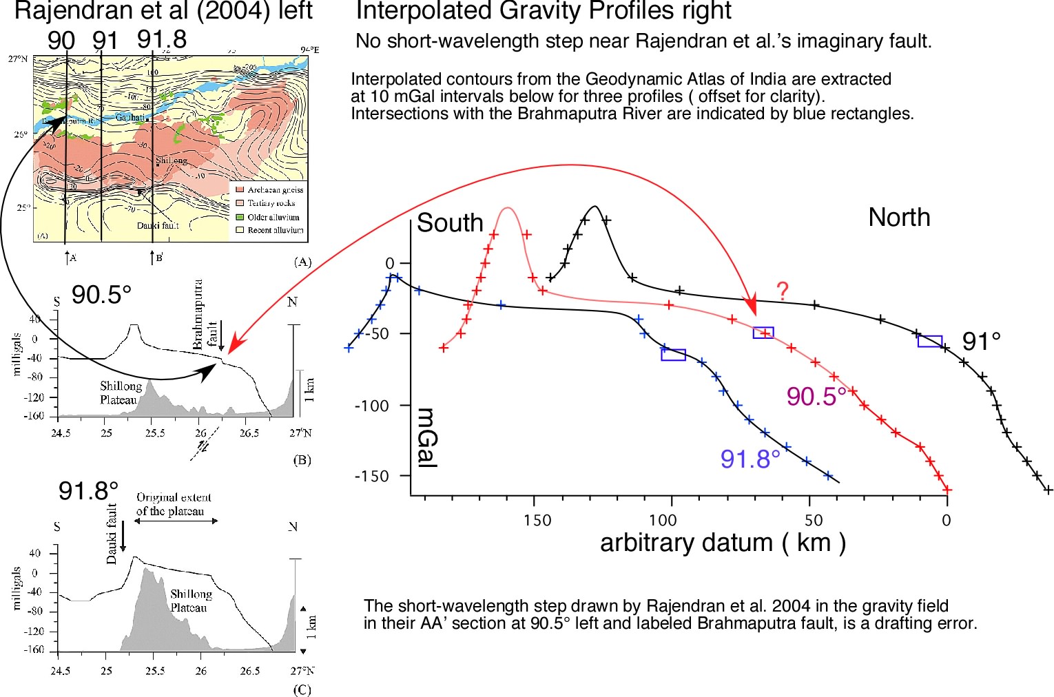
Articles by Rajendran et al. (Tectonics, 2004 & 2006) ignore the inferred rupture parameters, and newly evaluated MSK intensity data for the earthquake [refs 3&4]. Their articles are marred by faulty logic and errors in drafting and interpretation. One of their published profiles for gravity for example has been distorted to emphasize their case for a fault near the Brahmaputra river. Their hypothesis is not supported by SRTM digital elevation data, nor by any concentration of microearthquakes, nor by post-seismic vertical elevation changes [Fig3, ref 3], nor by gravity data when these are represented correctly. Moreover, had the Oldham fault ruptured to the surface it would have intersected the northern edge of the plateau at its western end, and have emerged some 20 km south of its northern edge at its eastern end. Thus their conjectured fault near the Brahmaputra, for which there is no geophysical support even in their article, has the wrong strike and is 50-70 km too far north. See critical discussion of these articles.
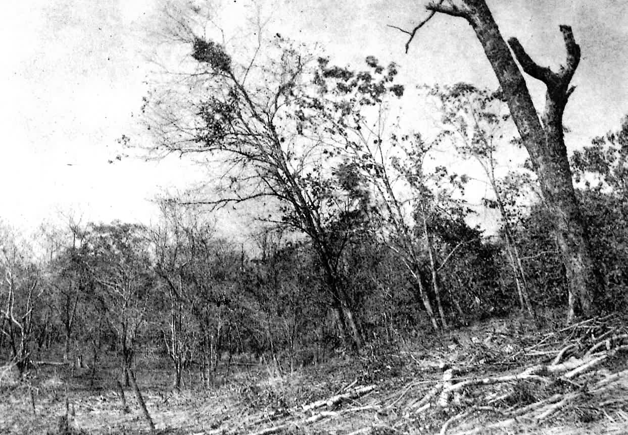
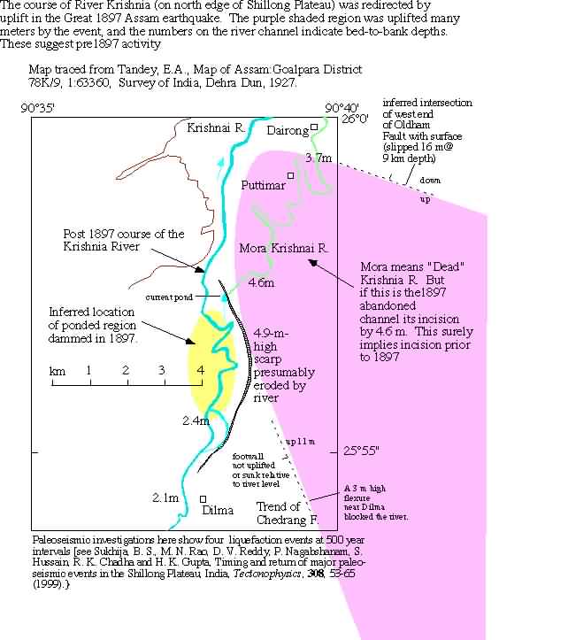
Rupture of the Oldham fault stopped, like the Bhuj 2001 rupture, 9 km below the surface. There is no evidence that primary surface faulting in 1897 ruptured to the surface even in distributed afterslip or folding, since this would have been manifest in the geodetic data.. Numerical analysis of slip on the Chedrang fault, a NNW trending normal fault at the western edge of the subsurface Oldham fault, confirms that its slip of 10 m is consistent with slip on the Oldham fault. The photo below from Oldham (1899) shows surface folding (tilted trees) above the northern end of the Chedrang fault where it crosses the surface projection of the footwall of the Oldham fault.
|
||||