Ancestral Cascades
Paleocanyon estimates of deposition history
Work has been done in the southern end of the arc to date and analyze the volcanic deposits that erupted from the Cascades in the area. Several studies looked at deposits in paleocanyons near the Carson Pass area just south of Lake Tahoe and examined the depositional relationships between the various layers. Previous mapping surveys had grouped all of these volcanic units into a general, undifferentiated group. Using 40Ar/39Ar dating, Busby et al. (2008a) were able to better resolve the different age groups that these rocks belonged to, and distinguish between two distinct periods of eruption.
The first eruptions were from central Nevada as part of an ignimbrite flare up around 31-23 Ma. These rhyolite tuffs filled existing canyons near the modern Sierra Nevada, and some of those deposits still exist at the surface today. The second phase of eruptions occurred from 22-5 Ma and is thought to be from the Ancestral Cascades that were located east of the Sierra Nevada. These units are further split into three main eruptive events that lasted from 15-14 Ma, 10-9 Ma, and 7-6 Ma.
These layers overlap each other in a very particular way, and by looking at the deposits in the paleocanyon, these researchers (Busby et al 2008a, Hagan et al. 2009) have unraveled the history and timing of deposition and erosion in this area (Figure 2, in Methodology), and they were able to infer something about the changing tectonics in this area over that time. They argue that each episode of incision marks a period of range-front faulting combined with the onset of uplift caused by the Ancestral Cascades themselves.
Major oxide and rare-earth geochemistry
Other studies of the southern extent of the Ancestral Cascades rely on geochemistry to understand the tectonics that were at play in the last 25 million years. By analyzing the abundance or depletion of certain elements in the rock, it is possible to determine the melt source material and say something about how these volcanoes formed. Furthermore, by comparing these element abundances to samples of the modern arc, it is possible to see how things have changed since the ancestral arc was created.
A paper by Cousens et al. (2008) studied the area just north of Lake Tahoe using dozens of samples of volcanic outcrops. They compared the geochemical makeup of their samples to samples from the southern modern Cascades and saw that while certain elemental signatures were similar, others showed significant differences. Looking at the rare-earth elements in the lava showed that they were enriched in incompatible elements compared to the modern arc (Figure 3, green area vs. blue area). This indicates that something happened to the initial melt before reaching the surface. The authors argue that this could be either a mixing of the primary melt from the slab with other mantle melts, or melting of mantle peridotite from fluids coming off the slab.
Busby et al. (2008b) also examined major oxides from the volcanics in the area and they found an interesting spatial pattern emerge. If these lavas were derived from a simple slab moving eastward, there should be relatively uniform chemistry along the arc. However by looking at potassium oxide concentrations at three sites along the arc they find significant abundances in the southern Sierra Nevada and depleted rocks toward the north (Figure 4). While K2O is often an indicator of slab depth and dip angle, they argue that this spatial pattern requires a different explanation. Their model invokes changes in crustal thickness that lead to differences in clinopyroxene, which in turn causes the potassium to become more incompatible. They argue for a thicker crust below the southern Sierra Nevada and a thinner crust near Lassen Peak (Figure 5). This argument is an interesting way to explain why the chemical signature is so different over a relatively small area.
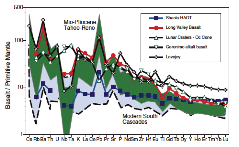
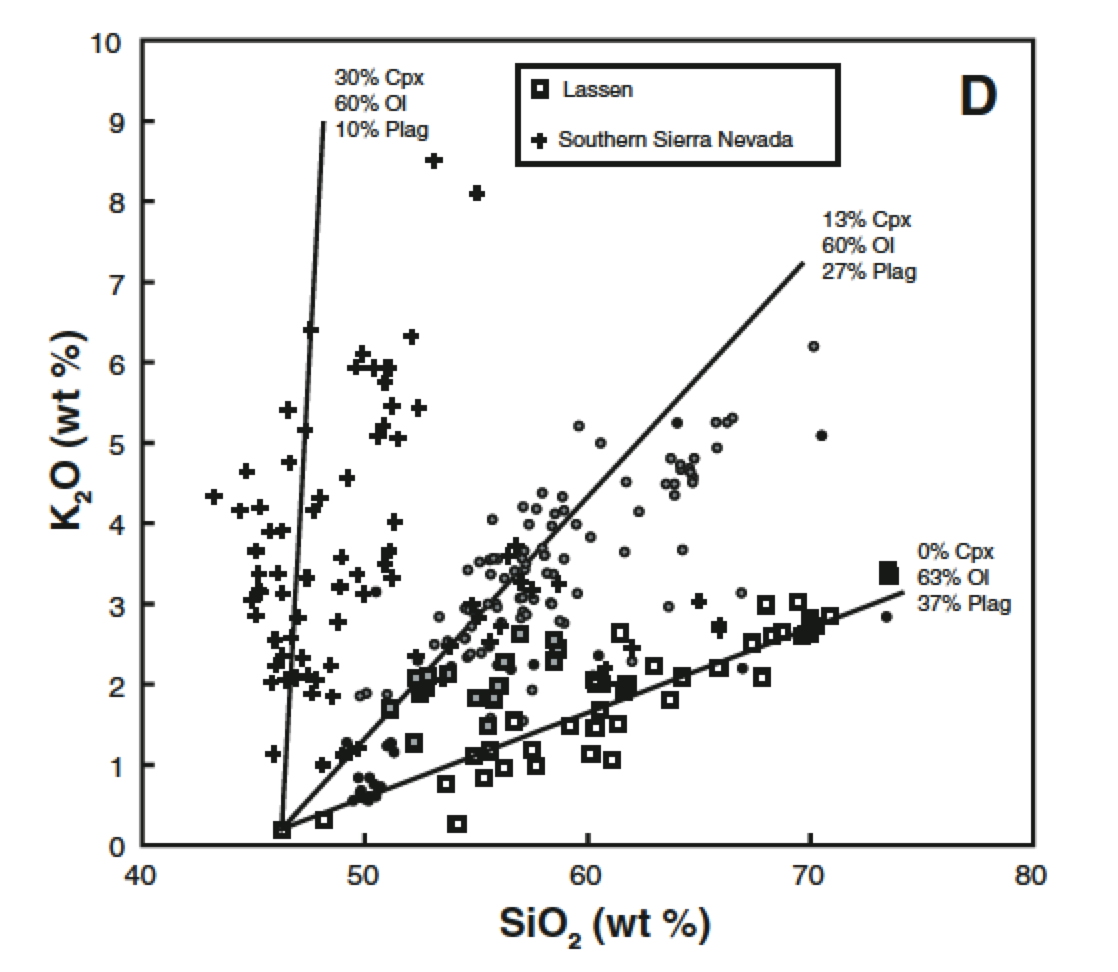
Figure 3 (left). Rare Earth Elements for the Ancestral (green) and Modern (blue) Cascades showing the relative abundance of incompatible elements in the Ancestral arc. From Cousens et al. 2008.
Figure 4(right). K2O vs SiO2 for three locations along the arc. Samples near Lassen Peak in the north show low K2O values while samples from the Southern Sierra Nevada show very high concentrations. From Busby et al. 2008b.
Geochemistry of the Western Cascades
Work has also been done in the Western Cascades, which parallel the modern arc in Washington, Oregon and northern California (Figure 1, in Introduction). A study from 2011 by DuBray and John compiled a massive 4000-sample database of geochemical analyses and age constraints up and down the arc. From this database they were able to distinguish several temporal patterns that might have escaped more traditional analyses. They plot the major oxide concentrations for Ti, Al, Fe, Mg, Ca, Na, K, and P with different markers for different time periods, which allows for easy identification of the time shift in concentrations. They then take a closer look at some of these elements and plot concentration vs. time, which reveals a surprising result (Figure 5). Looking at mean values for K2O and MgO, there appears to be a dramatic change in the trend at ~20 Ma.
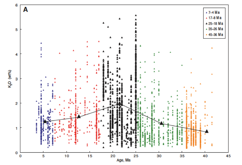
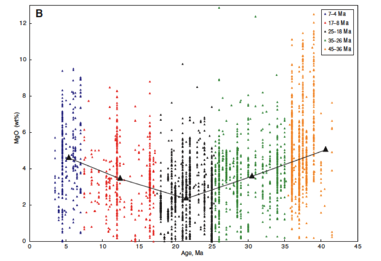
Figure 5. K2O (left) and MgO (right) concentrations over time. The average value (black line) shows a clear reversal of the trend, indicating some sort of change in melt source.
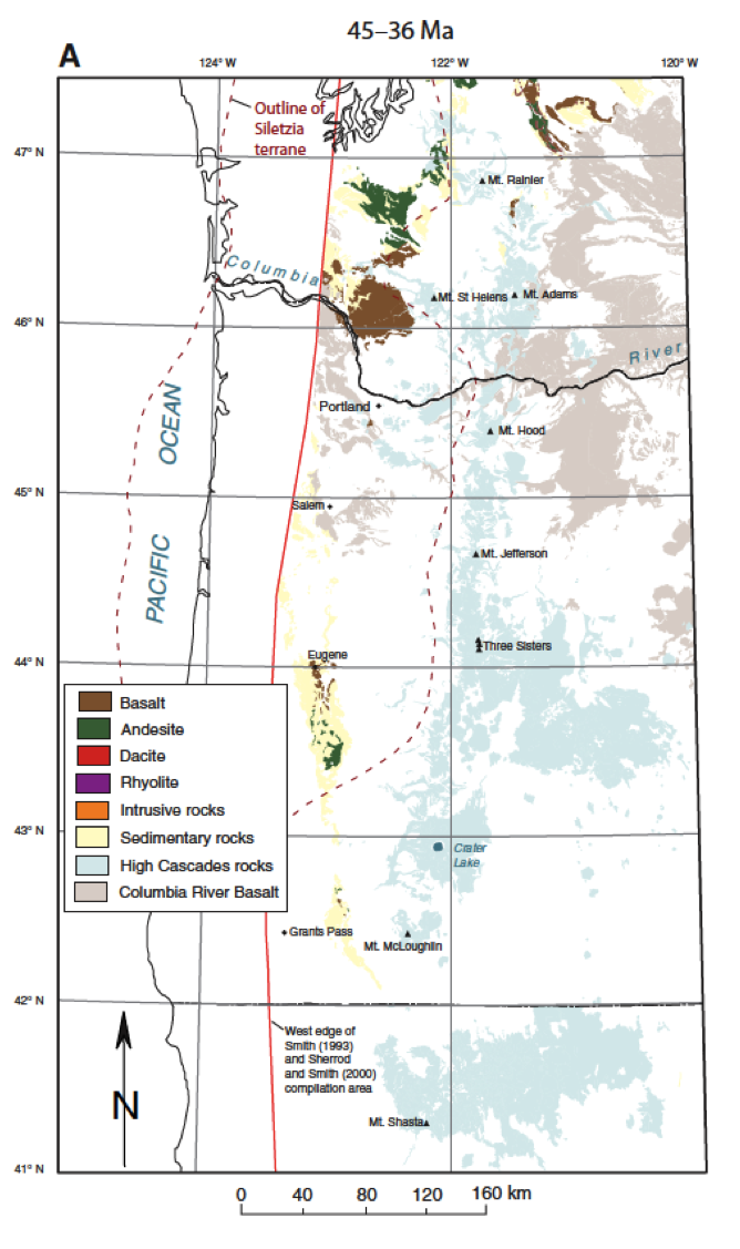
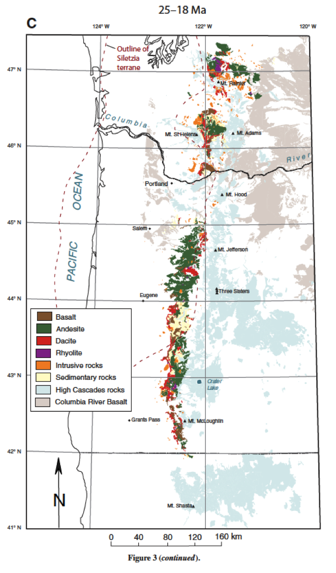
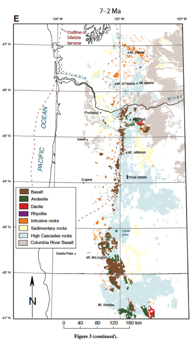
This trend also appears when they map the changes in composition of volcanics over time. The early rocks are mostly basaltic, and as time goes on the composition becomes more andesitic and dacitic until 20 Ma when most of the deposits are dacite. After 20 Ma this trend reverses and the rocks become more basaltic again (Figure 6). These observations, along with the trend of volcanic vents moving steadily eastward, indicates that the subducting slab was slowly flattening, until it reached the current position.
Conclusions
While these studies use different methods and study different locations, they all use volcanic deposits from the Ancestral Cascades to determine the tectonic history of the west coast of North America during the Cenozoic. They show that there was steep slab subduction in the Pacific Northwest that then became shallow, and that there may have been steeper subduction below the Sierra Nevada but that the crustal signature may be influencing the data. The deposits near Lake Tahoe revealed several distinct episodes of eruptions and helped constrain the timing of faulting along the western edge of the Basin and Range. What may have seemed like a semantic distinction between the modern Cascades in location and age has turned out to offer significant insights into the past 45 million years along the entire coast.
Figure 6. Maps of Washington and Oregon showing volcanic composition at different times, showing the shift from basaltic eruptions at 45-36 Ma to more dacitic rocks at 25-18 Ma, then shifting back toward basalt at 7-2 Ma.