Methodology - Paleocanyon analysis to derive tectonic history
One of the methods to study the Ancestral Cascades uses exposed paleocanyon deposits to back out the tectonic history of the area. Two such studies were published recently that examine paleocanyons near the Carson Pass area just south of Lake Tahoe (Busby et al. 2008, Hagan et al. 2009). Initial field work is essential in a study like this, and Busby et al. made an extensive review of the lithofacies and unconformities in the area. They found significant erosional unconformities throughout the area that break the units into six unconformity-bounded sequences. These sequences consist of volcanic intrusions, block and ash flow tuffs caused by lava-dome collapse, thick debris flow deposits, lava flows, and peperites which form by magma interacting with wet sediment.
In addition to the mapping, dates were obtained using 40Ar/39Ar radioisotopes. This allowed the mapped units to be grouped into separate eruptive events or episodes. In the Carson Pass area, there seem to be several periods of volcanism - an early ignimbrite flare up around 31-23 Ma, then Ancestral Cascade volcanism from 22-5 Ma that is further differentiated into groups clustered at 15-14 Ma, 10-9 Ma, and 7-6 Ma.
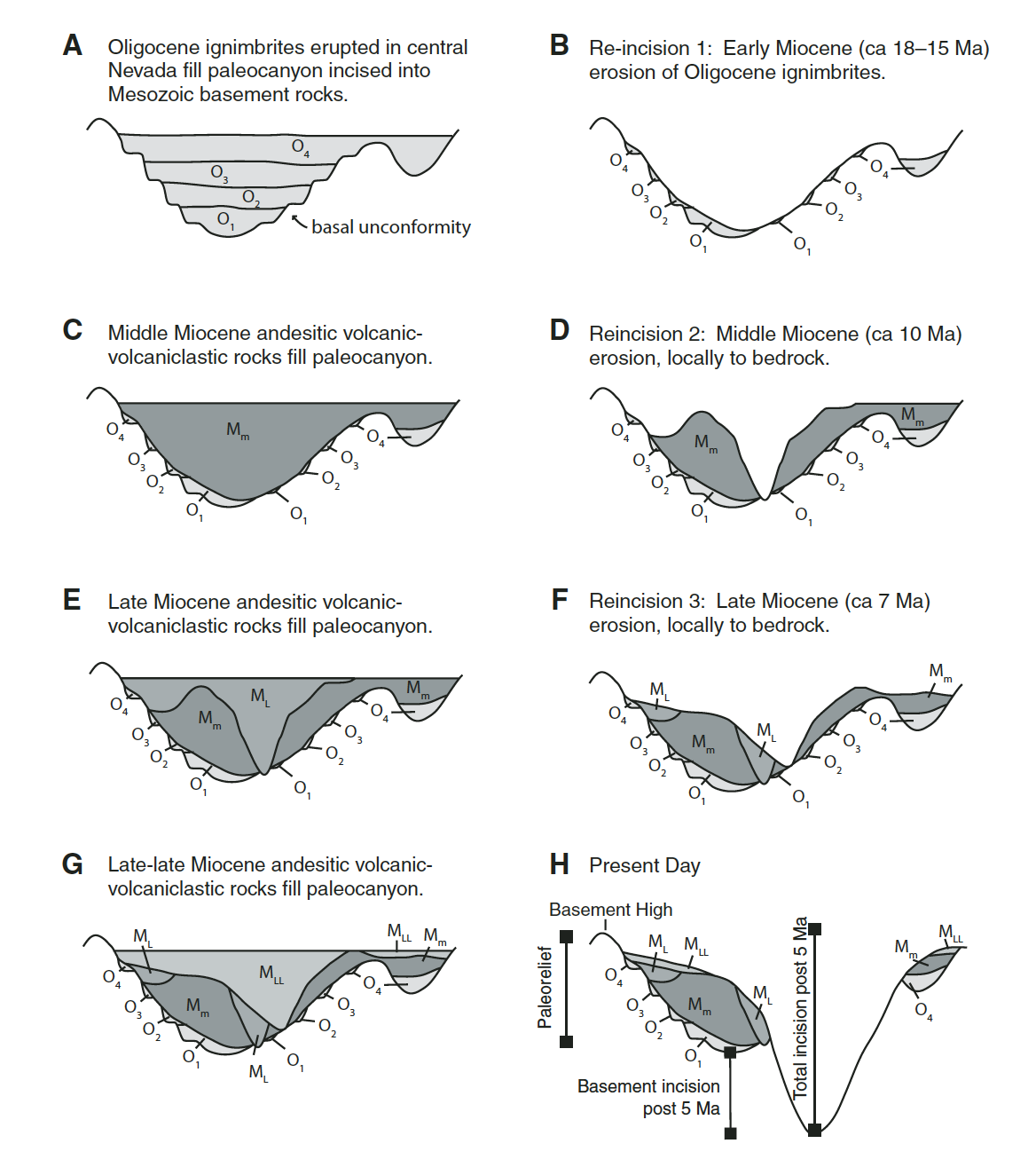
The last step is to examine the unconformities and make a history of the deposition vs erosion events that had to have happened. Assuming horizontal deposition, there must have been significant erosion in these units to expose them back to the surface and allow the next lava flow to cover the area. This cycle of deposition and erosion appears to have been repeated at least four times in the last 30 Ma (Figure 2).
From this deposition/incision history it is possible to infer tectonic events that may have caused such dramatic changes. A dramatic increase in incision most likely indicates an increase in topography and river slope. Hagan et al. argue that the incision events from 23-16, 13.5-11 and 10-7 Ma are related to range-front faulting and formation of what they term the Hope Valley graben. Busby et al. infer uplift caused by the Ancestral Cascades themselves, and/or movement of the triple junction through the area.
Figure 2. Model for the topographic evolution of the central Sierra Nevada from Busby et al. 2008 showing the major incision events.
